It looks like you're using an Ad Blocker.
Please white-list or disable AboveTopSecret.com in your ad-blocking tool.
Thank you.
Some features of ATS will be disabled while you continue to use an ad-blocker.

Historical Storm unfolding in Texas and Oklahoma
page: 5share:
a reply to: TechniXcality
Don't go outside, are you mad? Just be careful, for goodness sake. Even if you don't get swooped up, you could get hit with storm debris.
Don't take any chances, this thing looks a bit wild.
Don't go outside, are you mad? Just be careful, for goodness sake. Even if you don't get swooped up, you could get hit with storm debris.
Don't take any chances, this thing looks a bit wild.
Holy smokes. That's a rather large system. Is it modeled to continue moving East, SouthEast?? I was BBQ today and actually had to use the AC in my
car it was so warm yesterday. Perhaps this front will bring us actual cold weather to Florida, not that I want it.
In any case may good fortune be upon you during this event, and hopefully you are well insured against the worst case scenario. If you see anything interesting, bust out the phone and get some footage (non vertical please)
In any case may good fortune be upon you during this event, and hopefully you are well insured against the worst case scenario. If you see anything interesting, bust out the phone and get some footage (non vertical please)
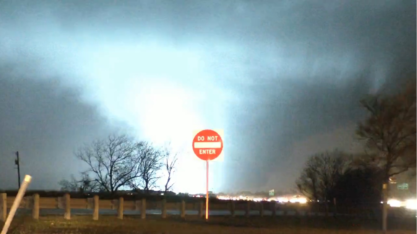
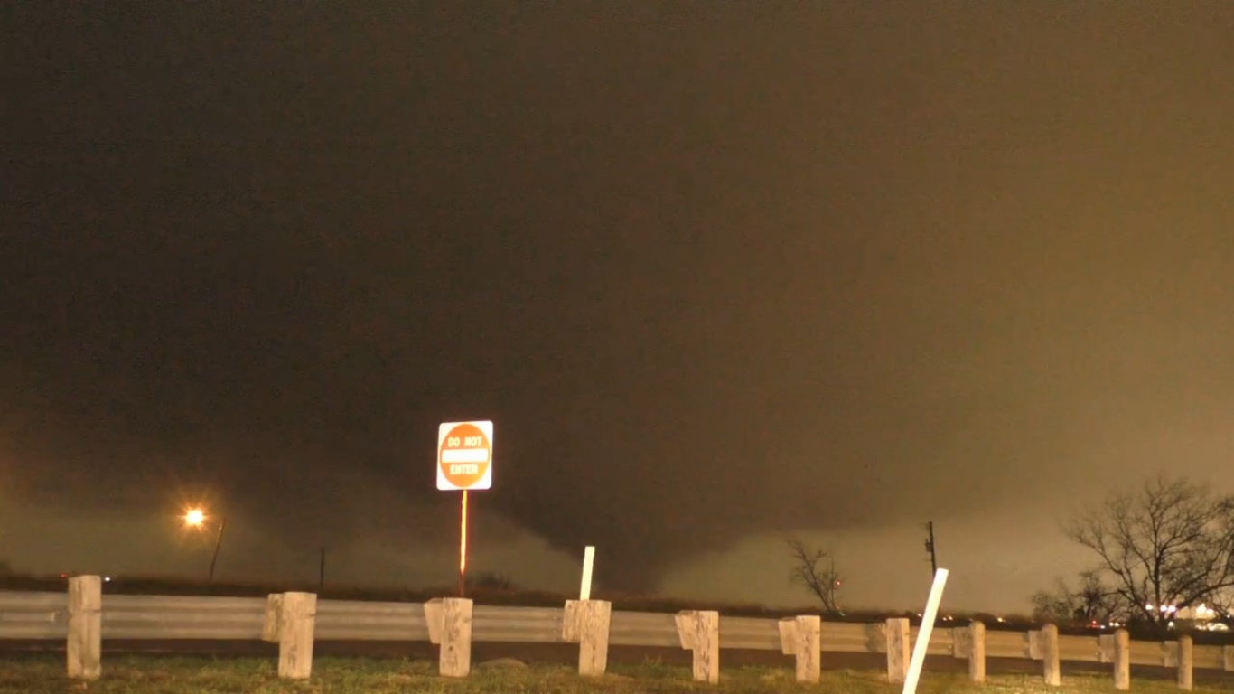
Watching one of the chasers at the moment he said the twister is at least a mile wide going through Garland on the way to Mobile City
Even with it being night it looks pretty nasty
Even with it being night it looks pretty nasty
That walley in Bolivar lost power 3 more times today, kind of odd, we are way east of you and all the extreme weather, just the foot knocking thunder
and lightning. Cant imagine what it must feel like where you are.
Stay safe.
Stay safe.
a reply to: ketsuko
I am taking shelter, the tornado has been lifting And completely destroy homes and launching things a mile in the air!
I am taking shelter, the tornado has been lifting And completely destroy homes and launching things a mile in the air!
Tornado Warning SEVERE WEATHER STATEMENT NATIONAL WEATHER SERVICE FORT WORTH TX 655 PM CST SAT DEC 26 2015 TXC085-113-397-270130- /O.CON.KFWD.TO.W.0148.000000T0000Z-151227T0130Z/ COLLIN TX-DALLAS TX-ROCKWALL TX- 655 PM CST SAT DEC 26 2015 ...A TORNADO WARNING REMAINS IN EFFECT UNTIL 730 PM CST FOR SOUTHERN COLLIN...NORTHEASTERN DALLAS AND WESTERN ROCKWALL COUNTIES... AT 654 PM CST...A CONFIRMED LARGE AND EXTREMELY DANGEROUS TORNADO WAS LOCATED OVER ROWLETT...MOVING NORTHEAST AT 40 MPH. THIS IS A PARTICULARLY DANGEROUS SITUATION. HAZARD...DAMAGING TORNADO. SOURCE...RADAR CONFIRMED TORNADO. IMPACT...YOU ARE IN A LIFE THREATENING SITUATION. FLYING DEBRIS MAY BE DEADLY TO THOSE CAUGHT WITHOUT SHELTER. MOBILE HOMES WILL BE DESTROYED. CONSIDERABLE DAMAGE TO HOMES...BUSINESSES AND VEHICLES IS LIKELY AND COMPLETE DESTRUCTION IS POSSIBLE. RADAR CONFIRMED DEBRIS WAS BEING LOFTED OVER 1 MILE IN THE AIR. THIS IS AN EXTREMELY DANGEROUS SITUATION. IF YOU ARE NEAR ROWLETT...TAKE COVER IMMEDIATELY TO PROTECT YOUR LIFE! THE TORNADO WILL BE NEAR... ROCKWALL AROUND 705 PM CST. WYLIE AROUND 715 PM CST. FARMERSVILLE AROUND 730 PM CST. OTHER LOCATIONS IMPACTED BY THIS TORNADIC THUNDERSTORM INCLUDE ST. PAUL...BUCKINGHAM...NEVADA AND LAVON. THIS INCLUDES THE FOLLOWING INTERSTATES... INTERSTATE 35E BETWEEN MILE MARKERS 425 AND 435. INTERSTATE 30 BETWEEN MILE MARKERS 41 AND 69. INTERSTATE 45 BETWEEN MILE MARKERS 280 AND 284. PRECAUTIONARY/PREPAREDNESS ACTIONS... A LARGE AND EXTREMELY DANGEROUS TORNADO IS ON THE GROUND. TAKE IMMEDIATE TORNADO PRECAUTIONS. THIS IS AN EMERGENCY SITUATION. && LAT...LON 3313 9632 3281 9649 3281 9652 3270 9674 3277 9689 3293 9689 3299 9684 3316 9684 TIME...MOT...LOC 0054Z 208DEG 33KT 3289 9654 TORNADO...OBSERVED TORNADO DAMAGE THREAT...CONSIDERABLE HAIL...1.00IN $$ CAVANAUGH
That is horrible to hear. It is just the nightmare scenario there. They'll get blasted today and then get the extreme cold tomorrow when they are all
without shelter and trying to find and help everyone. With a tornado that large, it's going to be a terrible, terrible time.
Thoughts and prayers to the people dealing with this one. They're going to need every pair of hands that make a difference for them, and the best I can do from here is send them my wishes right now.
Thoughts and prayers to the people dealing with this one. They're going to need every pair of hands that make a difference for them, and the best I can do from here is send them my wishes right now.
Power is out here...we just lost an 80-year old Burr Oak. sounds like some of it may have landed on my roof and/or in my attic. will continue to post
as long as my cell phone hot spot lasts. Stay safe!
Reporting temp has dropped in FW to 56 so maybe this will be over soon for Dallas area.
To the person who had tree fall...stay safe. Hope your roof is okay so no water damage.
To the person who had tree fall...stay safe. Hope your roof is okay so no water damage.
This sounds intimidating and scary. Please stay safe all our Texas friends.
It's horrible where I am in the SE-US. The temp is staying in high 70's and up to 80 yesterday. Last night it was 80 at 10:00 p.m. The humidity is probably 100% even if it's not actively raining. Even things in my house are wet. If I get a bottle of water out of the frig within a minute it has condensation pouring down the sides of the bottle. It's kinda miserable. People are turning their AC on to try to get rid of some of the humidity. So far I have refused to switch over to AC, but I might have to -- also my roses are still blooming. : o
We are under a constant warning of some kind or another. Floods, tornados, straight damaging winds; gusty winds. Miserable weather. I'm so afraid it will all culminate in giant tornados.
Keep us posted on how you are. I'll be checking in with the weather channel.
There are reports coming in of injuries homes completely destroy and even fatalities, this situation and storm are far from over, after tonight we
will have flooding rains tomorrow and then snow tomorrow night, i wouldn't be surprised if a state of emergency is declared. All prayers are with
those who have been directly effected.
new topics
-
God's Righteousness is Greater than Our Wrath
Religion, Faith, And Theology: 1 hours ago -
Electrical tricks for saving money
Education and Media: 4 hours ago -
VP's Secret Service agent brawls with other agents at Andrews
Mainstream News: 5 hours ago -
Sunak spinning the sickness figures
Other Current Events: 6 hours ago -
Nearly 70% Of Americans Want Talks To End War In Ukraine
Political Issues: 6 hours ago -
Late Night with the Devil - a really good unusual modern horror film.
Movies: 8 hours ago -
Cats Used as Live Bait to Train Ferocious Pitbulls in Illegal NYC Dogfighting
Social Issues and Civil Unrest: 9 hours ago -
The Good News According to Jesus - Episode 1
Religion, Faith, And Theology: 11 hours ago
top topics
-
Florida man's trip overseas ends in shock over $143,000 T-Mobile phone bill
Social Issues and Civil Unrest: 16 hours ago, 8 flags -
Cats Used as Live Bait to Train Ferocious Pitbulls in Illegal NYC Dogfighting
Social Issues and Civil Unrest: 9 hours ago, 8 flags -
VP's Secret Service agent brawls with other agents at Andrews
Mainstream News: 5 hours ago, 8 flags -
Bobiverse
Fantasy & Science Fiction: 16 hours ago, 3 flags -
HORRIBLE !! Russian Soldier Drinking Own Urine To Survive In Battle
World War Three: 14 hours ago, 3 flags -
Electrical tricks for saving money
Education and Media: 4 hours ago, 3 flags -
Nearly 70% Of Americans Want Talks To End War In Ukraine
Political Issues: 6 hours ago, 3 flags -
Sunak spinning the sickness figures
Other Current Events: 6 hours ago, 3 flags -
Late Night with the Devil - a really good unusual modern horror film.
Movies: 8 hours ago, 2 flags -
The Good News According to Jesus - Episode 1
Religion, Faith, And Theology: 11 hours ago, 1 flags
active topics
-
Electrical tricks for saving money
Education and Media • 4 • : Lumenari -
Cats Used as Live Bait to Train Ferocious Pitbulls in Illegal NYC Dogfighting
Social Issues and Civil Unrest • 19 • : WeMustCare -
VP's Secret Service agent brawls with other agents at Andrews
Mainstream News • 38 • : SchrodingersRat -
New whistleblower Jason Sands speaks on Twitter Spaces last night.
Aliens and UFOs • 54 • : Ophiuchus1 -
DONALD J. TRUMP - 2024 Candidate for President - His Communications to Americans and the World.
2024 Elections • 514 • : WeMustCare -
The Acronym Game .. Pt.3
General Chit Chat • 7744 • : bally001 -
Truth Social goes public, be careful not to lose your money
Mainstream News • 128 • : Astyanax -
Sunak spinning the sickness figures
Other Current Events • 5 • : glen200376 -
SETI chief says US has no evidence for alien technology. 'And we never have'
Aliens and UFOs • 44 • : MikeDeGrasseTyson -
HORRIBLE !! Russian Soldier Drinking Own Urine To Survive In Battle
World War Three • 31 • : budzprime69