It looks like you're using an Ad Blocker.
Please white-list or disable AboveTopSecret.com in your ad-blocking tool.
Thank you.
Some features of ATS will be disabled while you continue to use an ad-blocker.

Potential: Major winter storm Thanksgiving weekend effecting the southern plains/Texas!
page: 111
share:
Hey ATS I thought I would give you all an advanced look on a potential major winter storm effecting the southern plains starting Saturday, likely
local Mets have not said much if at all, as this is a week out and there is a potential for large variance, but if the model output of today is any
indicator, we could be talking about a major winter storm effecting the southern plains and possibly shutting down travel.
A word from NWS (national weather service) FT.Worth in their forecast discussion:
As indicated this is a week away and latching onto this scenario is not prudent yet, but it is a possibility and bears watching and since its the holiday weekend i figured i would give ATS the news first, now being a weather guy i can be wrong and i still don't get my lunch eat but I've been watching model trends, and believe the ugly head of El nino and a strong STJ (sub tropical jet) mixed with a arctic front may come to fruition, i primarily am going to speak about Texas because that is the state i live in, but all of the southern plains potentially could be under the gun, i cant stress enough things will change but lets look at some model data from today.
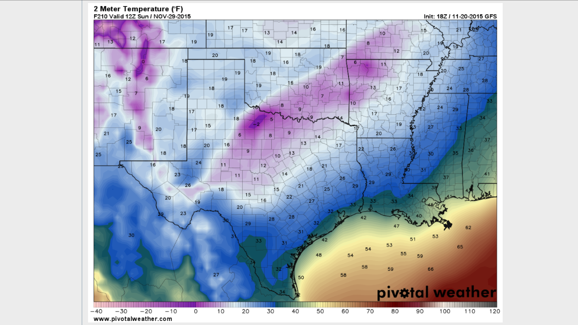
This model picture is showing the forecast 2meter temps (six feet above ground) in Texas on Sunday the 29th, temperatures in the single digits and teen! even the golf near freezing! This is a powerful arctic front if this were to verify it would be record breaking, only time will tell.
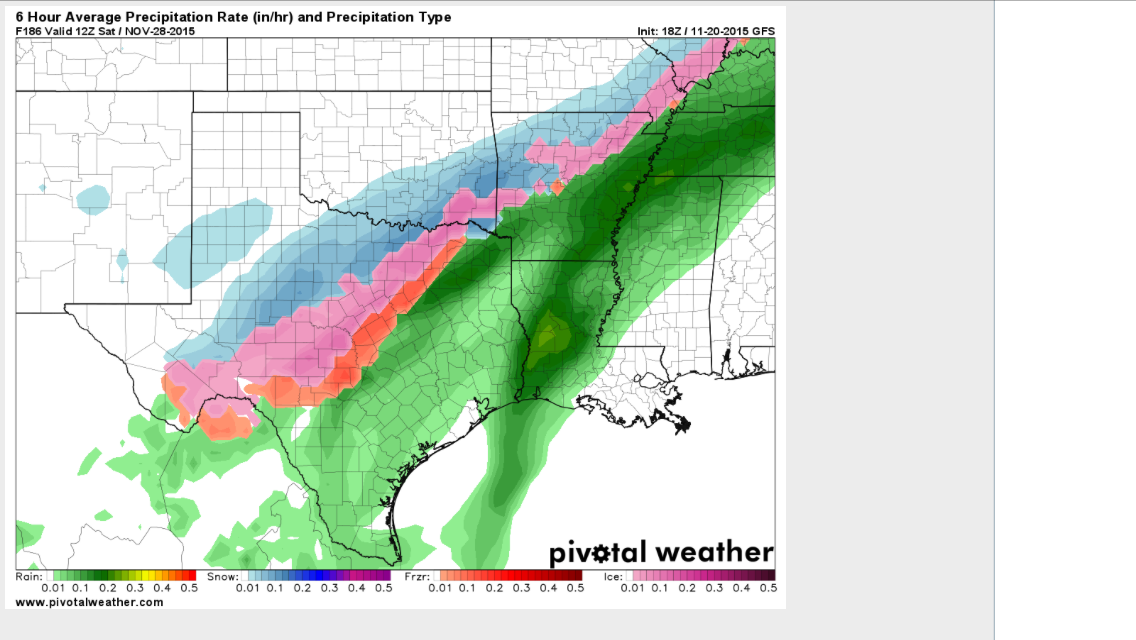
This model picture is showing the precip falling on Saturday the 28th, the freezing precip starts in the orange shades which is freezing rain, and the violet shades are sleet and the blue snow. This is a dangerous idea because the precip would start as rain,change to freezing rain, then sleet and then snow, and the driving conditions would become near impossible. here is another picture of the projected snow totals in Texas.
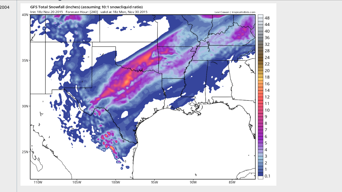
This model is showing huge swaths of over a foot of snow, in Texas and Oklahoma, its a winter wonderland lovers wet dream, i do not believe that this will be the case as this would such a rare event in Texas, however it is possible and so i am giving you the data.
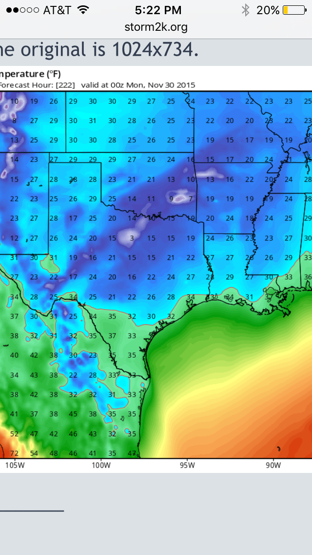
and another model showing the 2 meter temps on Monday the 30th after the major winter storm notice, the tempature where heavy snow is to fall are still in the single digits!
Everyone i will update this thread as we near closer to the event, there is a potential for a major winter storm including large amounts of ice/snow hopefully more snow than ice, however it could just be a cold rain event or even nothing at all. It is becoming more likely that a winter storm somewhere in the southern planes will come to fruition by thanksgiving weekend, just a heads up everyone be safe!
A word from NWS (national weather service) FT.Worth in their forecast discussion:
SATURDAY AND SUNDAY...FOR THOSE WATCHING RAW MODEL OUTPUT THIS FAR
OUT...IT IS EASY TO NOTICE THAT TEMPERATURES IN FORECAST SOUNDINGS
DROP BELOW FREEZING WHILE STILL INDICATING GOOD CHANCES FOR
PRECIPITATION DURING THE DAY ON SATURDAY. THINK THAT OUR CHANCES
OF FROZEN PRECIPITATION ARE NOT QUITE AS GOOD AS RAW MODEL
GUIDANCE IS ADVERTISING BECAUSE OF THE PROGGED POSITION OF THE
UPPER TROUGH ON THE DYNAMIC TROPOPAUSE MAPS DURING THIS TIME. THE
DYNAMIC TROPOPAUSE MAPS KEEP THE UPPER LEVEL POTENTIAL VORTICITY
RESERVOIR OVER THE CENTRAL PLAINS. WHILE SHALLOW COLD AIR CAN
CERTAINLY "OUT RUN" THE POTENTIAL VORTICITY RESERVOIR ALOFT...DEEP
COLD AIR WILL REMAIN TIED TO THIS RESERVOIR. THE DYNAMIC
TROPOPAUSE HELPS DETERMINE THE DEPTH OF THE TROPOSPHERE...WHICH IS
MINIMIZED UNDER THE PV RESERVOIR ALOFT. A LOW THICKNESS
TROPOSPHERE DIRECTLY CORRELATES TO A COLDER AIRMASS ON
AVERAGE...MEANING THAT COLD AIR WILL GENERALLY REMAIN TIED TO THIS
FEATURE ALOFT. WITH NORTH CENTRAL TEXAS REMAINING SOUTH OF THIS
RESERVOIR ALOFT...THINK THAT THE POTENTIAL FOR US TO RECEIVE DEEP
COLD AIR IS LOW...MAKING A COLD RAIN MORE LIKELY THAN A FROZEN
PRECIPITATION EVENT AT THIS TIME. WILL KEEP A CLOSE EYE ON THIS
SYSTEM IN THE COMING DAYS.
CAVANAUGH
As indicated this is a week away and latching onto this scenario is not prudent yet, but it is a possibility and bears watching and since its the holiday weekend i figured i would give ATS the news first, now being a weather guy i can be wrong and i still don't get my lunch eat but I've been watching model trends, and believe the ugly head of El nino and a strong STJ (sub tropical jet) mixed with a arctic front may come to fruition, i primarily am going to speak about Texas because that is the state i live in, but all of the southern plains potentially could be under the gun, i cant stress enough things will change but lets look at some model data from today.
This model picture is showing the forecast 2meter temps (six feet above ground) in Texas on Sunday the 29th, temperatures in the single digits and teen! even the golf near freezing! This is a powerful arctic front if this were to verify it would be record breaking, only time will tell.
This model picture is showing the precip falling on Saturday the 28th, the freezing precip starts in the orange shades which is freezing rain, and the violet shades are sleet and the blue snow. This is a dangerous idea because the precip would start as rain,change to freezing rain, then sleet and then snow, and the driving conditions would become near impossible. here is another picture of the projected snow totals in Texas.
This model is showing huge swaths of over a foot of snow, in Texas and Oklahoma, its a winter wonderland lovers wet dream, i do not believe that this will be the case as this would such a rare event in Texas, however it is possible and so i am giving you the data.
and another model showing the 2 meter temps on Monday the 30th after the major winter storm notice, the tempature where heavy snow is to fall are still in the single digits!
Everyone i will update this thread as we near closer to the event, there is a potential for a major winter storm including large amounts of ice/snow hopefully more snow than ice, however it could just be a cold rain event or even nothing at all. It is becoming more likely that a winter storm somewhere in the southern planes will come to fruition by thanksgiving weekend, just a heads up everyone be safe!
Thank you!
I am hoping the models are wrong as I do NOT want to go through another ice storm like we had in February.
Not as if I can stop it if it's coming LOL, need cheap flights out!
It was horrendous!
I now am going to look up our forecast models for our local weather.
It certainly was beautiful but scary too!
Thank Tech!
a reply to: TNMockingbird
ill take a look at TN a little later, im just making preliminary statements now, don't want to hype up to much. You are welcome just doing my due-diligence ma'am
ill take a look at TN a little later, im just making preliminary statements now, don't want to hype up to much. You are welcome just doing my due-diligence ma'am
I love your ATS weather reports Thank you.
Send some snow south to GA!
Send some snow south to GA!
a reply to: ~Lucidity
Thanks the potential is there that even Georgia could get in on the action will update further. I get all giddy inside when models start producing feet of snow over Texas and the southern planes makes me feel like a kid again, and what a perfect time for the holiday weekend.
Thanks the potential is there that even Georgia could get in on the action will update further. I get all giddy inside when models start producing feet of snow over Texas and the southern planes makes me feel like a kid again, and what a perfect time for the holiday weekend.
a reply to: TNMockingbird
I'm guessing, as usual, no snow for us. I love the snow and always watch these forecasts like a little kid waiting to open Christmas presents.
I'm (secretly) hoping that our area gets dumped on this year. I'll take a couple feet for a day or two.
I'm guessing, as usual, no snow for us. I love the snow and always watch these forecasts like a little kid waiting to open Christmas presents.
I'm (secretly) hoping that our area gets dumped on this year. I'll take a couple feet for a day or two.
a reply to: Doodle19815
According to this model run TN is getting anywhere between 1-4 inches not so fast hold out hope! We will be building snowman, I feel the same way which is part of my passion for weather. Cheers I'll update soon
According to this model run TN is getting anywhere between 1-4 inches not so fast hold out hope! We will be building snowman, I feel the same way which is part of my passion for weather. Cheers I'll update soon
This is a great read. I loled. And I'm hoping you get something exciting coming(but nothing too dangerous, ok?!).
Fingers crossed,
Louise!
Fingers crossed,
Louise!
a reply to: Doodle19815
I understand exactly how you feel LOL!
Weather reports call for snow and we get stuck with freezing rain or ice...
Up here on the mountain it usually turns to snow though
Just enough to muck everything up!
I understand exactly how you feel LOL!
Weather reports call for snow and we get stuck with freezing rain or ice...
Up here on the mountain it usually turns to snow though
Just enough to muck everything up!
Great.....I hope not. I'm really pulling for global warming. I hate the cold and rising sea levels could make new beaches.
I drive a firetruck in one of "the big" cities, and running hot on black ice is no bueno.
I drive a firetruck in one of "the big" cities, and running hot on black ice is no bueno.
a reply to: TechniXcality
I secretly hope the most exciting thing will be seeing one another's faces, and not some crazy storm!
But I still got my fingers crossed for you,
love,
Louise.
I secretly hope the most exciting thing will be seeing one another's faces, and not some crazy storm!
But I still got my fingers crossed for you,
love,
Louise.
Long Range for Sat 11/28/2015 here in Chicago is Chance of Rain..48 degrees. But the NWS says that the models are "all over the place" this far out.
I guess we'll need to get closer to that weekend to be certain if Texas will be cold enough to snow. But with the Globe WARMING, anything is
possible!
a reply to: carewemust
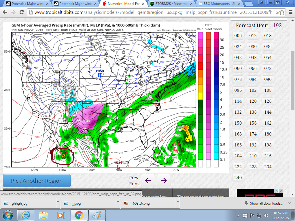
The 0z GFS model is still calling for a major winter storm, however this is an extreme ice event on this run. I however do not believe it will all be ice because such dense shallow arctic air-masses tend to out run the deterministic model predictions, they tend to struggle with such cold air, also notice the red circle in the bottom left hand corner, i circled that because the GFS is indicating a major EPAC hurricane, which will feed moisture directly into Texas over mexico, this situation could get very serious if models continue to trend this direction, and also mexico may be under threat of a major hurricane. more to come ..

I hope that this is not indicating a major ice storm and that instead the arctic air will out run and thus producing more snow than ice, time will tell

The 0z GFS model is still calling for a major winter storm, however this is an extreme ice event on this run. I however do not believe it will all be ice because such dense shallow arctic air-masses tend to out run the deterministic model predictions, they tend to struggle with such cold air, also notice the red circle in the bottom left hand corner, i circled that because the GFS is indicating a major EPAC hurricane, which will feed moisture directly into Texas over mexico, this situation could get very serious if models continue to trend this direction, and also mexico may be under threat of a major hurricane. more to come ..
I hope that this is not indicating a major ice storm and that instead the arctic air will out run and thus producing more snow than ice, time will tell
And the CMC (Canadian) 00z forecast model also going for a major ice storm in the great state of Texas, more to come..
Notice the EPAC hurricane circled, also the CMC is much wetter and probably more realistic considering the STJ and convection and moisture feed coming off of soon to be "Sandra" if she materializes.
Notice the EPAC hurricane circled, also the CMC is much wetter and probably more realistic considering the STJ and convection and moisture feed coming off of soon to be "Sandra" if she materializes.
edit on 20-11-2015 by TechniXcality because: (no reason given)
I have found climate change in the Bible and it was foretold before it happened. Seems there were seven years of good perfect weather for growing and
then followed by global warming that caused severe weather conditions for the whole world. There is no link though to it being man made or not but it
was known as said to be of God. God brought this severe weather about and foretold it to a man to preserve his people, Israel.
So if God controls the weather why would we think any different today and just say it is man made or just nature?
Why would God allow the severe weather today to affect so many in the way it does?
see underlined text. This is more than just misguided superstitious shepherds that made this claim.
So if God controls the weather why would we think any different today and just say it is man made or just nature?
Why would God allow the severe weather today to affect so many in the way it does?
see underlined text. This is more than just misguided superstitious shepherds that made this claim.
Gen 41:17-32 ¶ And Pharaoh said unto Joseph, In my dream, behold, I stood upon the bank of the river: And, behold, there came up out of the river seven kine, fatfleshed and well favoured; and they fed in a meadow: And, behold, seven other kine came up after them, poor and very ill favoured and leanfleshed, such as I never saw in all the land of Egypt for badness: And the lean and the ill favoured kine did eat up the first seven fat kine: And when they had eaten them up, it could not be known that they had eaten them; but they were still ill favoured, as at the beginning. So I awoke. And I saw in my dream, and, behold, seven ears came up in one stalk, full and good: And, behold, seven ears, withered, thin, and blasted with the east wind, sprung up after them: And the thin ears devoured the seven good ears: and I told this unto the magicians; but there was none that could declare it to me. And Joseph said unto Pharaoh, The dream of Pharaoh is one: God hath shewed Pharaoh what he is about to do. The seven good kine are seven years; and the seven good ears are seven years: the dream is one. And the seven thin and ill favoured kine that came up after them are seven years; and the seven empty ears blasted with the east wind shall be seven years of famine. This is the thing which I have spoken unto Pharaoh: What God is about to do he sheweth unto Pharaoh. Behold, there come seven years of great plenty throughout all the land of Egypt: And there shall arise after them seven years of famine; and all the plenty shall be forgotten in the land of Egypt; and the famine shall consume the land; And the plenty shall not be known in the land by reason of that famine following; for it shall be very grievous. And for that the dream was doubled unto Pharaoh twice; it is because the thing is established by God, and God will shortly bring it to pass.
edit on 21-11-2015 by ChesterJohn because: (no reason given)
a reply to: TNMockingbird
here's what we got so far, we shall see what happens im optimistic

ill post more model data including TN forecast
here's what we got so far, we shall see what happens im optimistic
ill post more model data including TN forecast
a reply to: TechniXcality
From NWS for west Texas and panhandle
From NWS for west Texas and panhandle
Ice Storm Warning
URGENT - WINTER WEATHER MESSAGE
NATIONAL WEATHER SERVICE AMARILLO TX
329 PM CST WED NOV 25 2015
...SIGNIFICANT WINTER STORM EXPECTED THURSDAY NIGHT THROUGH
SATURDAY...
OKZ003-TXZ003>005-007>020-260530-
/O.UPG.KAMA.WS.A.0003.151127T0000Z-151128T1800Z/
/O.NEW.KAMA.IS.W.0001.151127T0600Z-151128T1800Z/
BEAVER-HANSFORD-OCHILTREE-LIPSCOMB-MOORE-HUTCHINSON-ROBERTS-
HEMPHILL-OLDHAM-POTTER-CARSON-GRAY-WHEELER-DEAF SMITH-RANDALL-
ARMSTRONG-DONLEY-COLLINGSWORTH-
INCLUDING THE CITIES OF...BEAVER...FORGAN...SPEARMAN...GRUVER...
PERRYTON...BOOKER...HIGGINS...FOLLETT...DUMAS...BORGER...MIAMI...
CANADIAN...VEGA...AMARILLO...PANHANDLE...WHITE DEER...PAMPA...
SHAMROCK...WHEELER...HEREFORD...CANYON...CLAUDE...CLARENDON...
WELLINGTON
329 PM CST WED NOV 25 2015
...ICE STORM WARNING IN EFFECT FROM MIDNIGHT THURSDAY NIGHT TO
NOON CST SATURDAY...
THE NATIONAL WEATHER SERVICE IN AMARILLO HAS ISSUED AN ICE STORM
WARNING...WHICH IS IN EFFECT FROM MIDNIGHT THURSDAY NIGHT TO NOON
CST SATURDAY. THE WINTER STORM WATCH IS NO LONGER IN EFFECT.
* EVENT...RAIN SHOWERS WILL TRANSITION TO FREEZING RAIN THURSDAY
NIGHT WITH PERIODS OF FREEZING RAIN EXPECTED THROUGH MIDDAY
SATURDAY ACROSS THE MAJORITY OF THE TEXAS PANHANDLE AND EASTERN
OKLAHOMA PANHANDLE. ICE ACCUMULATIONS OF ONE QUARTER TO ONE HALF
INCH ARE EXPECTED WITH LOCALLY HIGHER AMOUNTS POSSIBLE. SLEET WILL
LIKELY MIX IN FROM TIME TO TIME.
* TIMING...RAIN WILL CHANGE OVER TO FREEZING RAIN THURSDAY NIGHT AND
PERSIST THROUGH SATURDAY.
* IMPACTS...ROADS...BRIDGES...AND OVERPASSES IN THE WATCH AREA WILL
LIKELY BECOME SLICK AND HAZARDOUS DUE TO ACCUMULATING ICE.
EXERCISE CAUTION AND BE PREPARED FOR ROAD CLOSURES IF TRAVEL IS
NECESSARY.
PRECAUTIONARY/PREPAREDNESS ACTIONS...
AN ICE STORM WARNING MEANS SEVERE WINTER WEATHER CONDITIONS ARE
EXPECTED. SIGNIFICANT AMOUNTS OF ICE ACCUMULATIONS WILL MAKE
TRAVEL DANGEROUS OR IMPOSSIBLE. TRAVEL IS STRONGLY DISCOURAGED
THURSDAY NIGHT THROUGH SATURDAY. COMMERCE WILL LIKELY BE SEVERELY
IMPACTED. IF YOU MUST TRAVEL...KEEP AN EXTRA FLASHLIGHT...FOOD...AND
WATER IN YOUR VEHICLE IN CASE OF AN EMERGENCY. ICE ACCUMULATIONS AND
WINDS WILL LIKELY LEAD TO SNAPPED POWER LINES AND FALLING TREE
BRANCHES THAT ADD TO THE DANGER.
new topics
-
Intro once again
Introductions: 10 minutes ago -
University student disciplined after saying veganism is wrong and gender fluidity is stupid
Education and Media: 1 hours ago -
Geddy Lee in Conversation with Alex Lifeson - My Effin’ Life
People: 2 hours ago -
God lived as a Devil Dog.
Short Stories: 2 hours ago -
Police clash with St George’s Day protesters at central London rally
Social Issues and Civil Unrest: 4 hours ago -
TLDR post about ATS and why I love it and hope we all stay together somewhere
General Chit Chat: 5 hours ago -
Hate makes for strange bedfellows
US Political Madness: 7 hours ago -
Who guards the guards
US Political Madness: 9 hours ago -
Has Tesla manipulated data logs to cover up auto pilot crash?
Automotive Discussion: 11 hours ago
top topics
-
Hate makes for strange bedfellows
US Political Madness: 7 hours ago, 14 flags -
Who guards the guards
US Political Madness: 9 hours ago, 13 flags -
whistleblower Captain Bill Uhouse on the Kingman UFO recovery
Aliens and UFOs: 16 hours ago, 11 flags -
Police clash with St George’s Day protesters at central London rally
Social Issues and Civil Unrest: 4 hours ago, 7 flags -
TLDR post about ATS and why I love it and hope we all stay together somewhere
General Chit Chat: 5 hours ago, 5 flags -
University student disciplined after saying veganism is wrong and gender fluidity is stupid
Education and Media: 1 hours ago, 3 flags -
Has Tesla manipulated data logs to cover up auto pilot crash?
Automotive Discussion: 11 hours ago, 2 flags -
God lived as a Devil Dog.
Short Stories: 2 hours ago, 2 flags -
Geddy Lee in Conversation with Alex Lifeson - My Effin’ Life
People: 2 hours ago, 2 flags -
Intro once again
Introductions: 10 minutes ago, 1 flags
active topics
-
Mandela Effect - It Happened to Me!
The Gray Area • 114 • : ArMaP -
Silent Moments --In Memory of Beloved Member TDDA
Short Stories • 69 • : Naftalin -
Hate makes for strange bedfellows
US Political Madness • 32 • : theatreboy -
Police clash with St George’s Day protesters at central London rally
Social Issues and Civil Unrest • 36 • : FlyersFan -
"We're All Hamas" Heard at Columbia University Protests
Social Issues and Civil Unrest • 249 • : marg6043 -
Europe declares war on Russia?
World War Three • 66 • : Consvoli -
Candidate TRUMP Now Has Crazy Judge JUAN MERCHAN After Him - The Stormy Daniels Hush-Money Case.
Political Conspiracies • 732 • : matafuchs -
Spectrophilia - Women Who Have Had Affairs With Ghosts Say Spooks Are Better Lovers Than Real Men
Paranormal Studies • 28 • : FlyersFan -
Intro once again
Introductions • 0 • : Angrybrewer2 -
University student disciplined after saying veganism is wrong and gender fluidity is stupid
Education and Media • 6 • : Consvoli
11