It looks like you're using an Ad Blocker.
Please white-list or disable AboveTopSecret.com in your ad-blocking tool.
Thank you.
Some features of ATS will be disabled while you continue to use an ad-blocker.

'Tanks' at Antarctic 'UFO Crash Site' Found in Previous Satellite Images?
page: 1share:
Remember the alleged 'UFO crash site' photo from a 2012 Google Earth image that made the rounds back around July after being discovered by Russian UFO
researcher, Valentin Degterev? The image made it into the mainstream (albeit tabloid-y) news outlets such as
The Daily Mail:
Well it seems that somebody has found an image purporting to be from the same site and taken a year earlier. If this information is accurate (and I'm looking for some to substantiate this) then there's something more than a simple crevice going on here.
From Mysterious Universe - Strange Vehicles Found at UFO Landing Site in Antarctica
If anyone has links to the source of the image or links to the original appearance of this image, please post. I'll see what I can find.
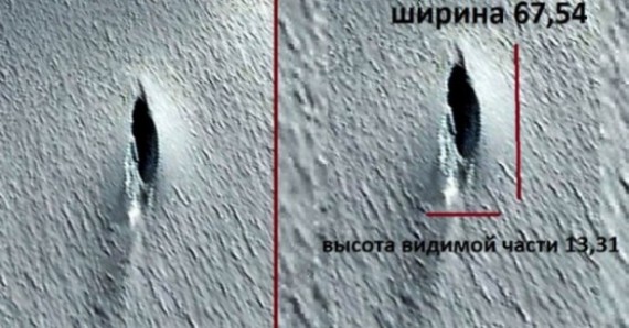
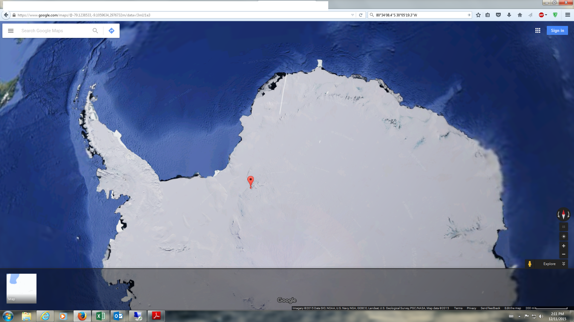
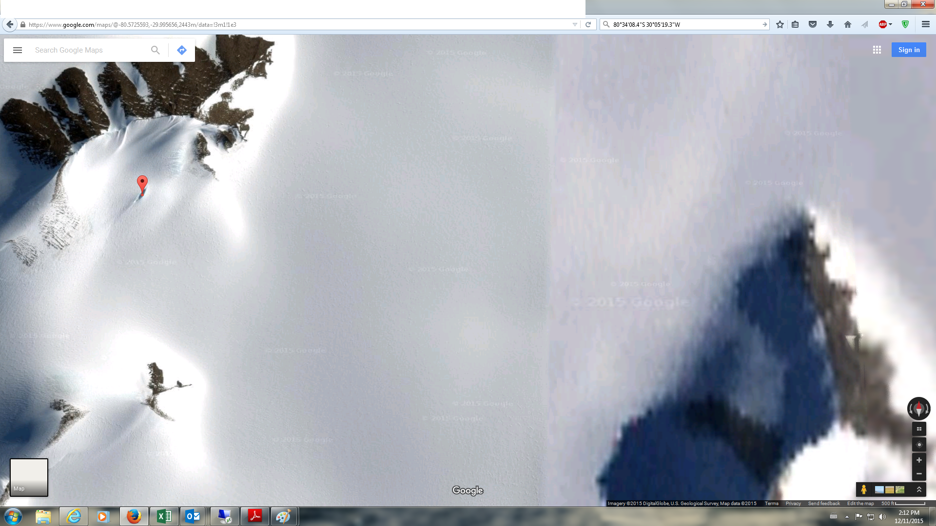
Anyone can view the object by inputting the coordinates 80°34'08.4"S 30°05'19.3"W into Google Maps.
‘I found the unique object using the online service of Google Earth in Antarctica,’ said Mr Degterev.
‘In amongst the endless ice desert, it is the most genuine UFO in its most classic shape.’
Tellingly, the object of interest is among many other cliffs and shadows, and doesn't particularly look like anything out of this world.
But Andrew Fleming from the British Antarctic Survey, told MailOnline that the object was quite clearly simply a crevasse in the ground.
'A crevasse is a lot of ice formed by differential movement of the ice,' he said.
'They can be tens of metres deep. It's one large slot, nothing unusual, but they are spectacular. It's certainly not a UFO, though.'
Well it seems that somebody has found an image purporting to be from the same site and taken a year earlier. If this information is accurate (and I'm looking for some to substantiate this) then there's something more than a simple crevice going on here.
From Mysterious Universe - Strange Vehicles Found at UFO Landing Site in Antarctica
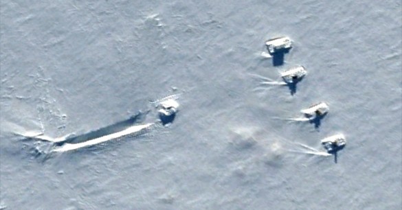
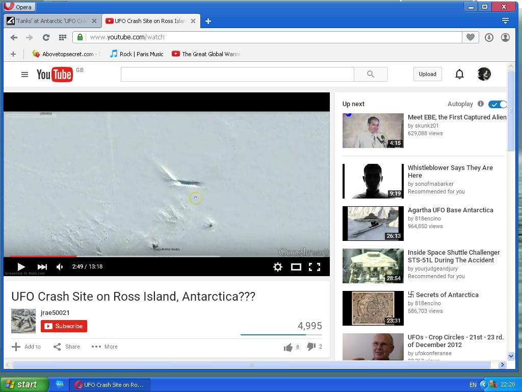
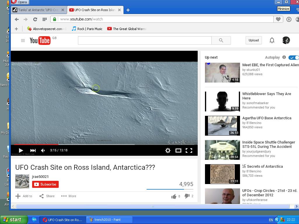
Researchers looking at previous satellite images of the same site taken in April 2011 and December 2011 found what appear to be four massive vehicles parked in the snow and pointed at the crack. In addition, these prior images show what could be the actual flying saucer with a skid mark in the snow making it look like the craft landed, possibly in an emergency.
What should we make of these earlier satellite images? While some reports identify the shapes as “tanks,” if they really are vehicles, they’re massive in size, probably around 70 feet in length. There are no tire tracks, but they could have been covered by snow or blown away.
If anyone has links to the source of the image or links to the original appearance of this image, please post. I'll see what I can find.
edit
on 2015-11-12 by theantediluvian because: (no reason given)
Did a reverse image search on my Veracity App and this is the earliest result I could find for the photo.
15th Aug 2012.
Haven't watched the video though.
Wasn't this posted a few years back?
I think they just turned out to be weather stations or something.
I think they just turned out to be weather stations or something.
edit on 12-11-2015 by MrMasterMinder because: (no reason given)
They are not 'tanks' they are stacked storage containers. There is probably a thread here somewhere about the same subject.
edit on 12-11-2015
by smurfy because: Text.
a reply to: theantediluvian
Just found a 'MaxRes' version.
The 'tank' objects remind me of buildings seen from above. The length and contrast of the shadows suggest buildings that are similar in design to churches with tall towers. At the same time, those shadows seem out of place and it's hard to work out what exactly could be casting a long shadow.
You have to query why there is no link to these alleged satellite images, and why there is no wider context of the images to show similar scenery to
the one in the previous image of the hole in the ice (which is all it is).
Until then: photoshop
Until then: photoshop
They are not tanks however tracked vehicles...I was informed by a family member whom use to fly down to Antarctica for Operation Deep Freeze...He
stated that tracked construction equipment such as excavators and dozers make a hole/pit so they can collect their drinking water and that the photo
you are seeing are those vehicles covered in snow and the pit they dug
As Far as UFOs down their most definitely here is same family member as above describe such personal account Here:
US Navy Engineer
P.S. this is also where sometimes they land the C-130 that has ski's for resupply to the various stations close to Murdoch station I believe depending on weather conditions...The heavy equipment also clears makeshift runways as well
edit on 12-11-2015 by Raven1354 because: (no reason
given)
edit on 12-11-2015 by Raven1354 because: (no reason given)
They are all different in size and detail and none have tracks leading up to them, so I'll guess they are not tanks, but rather a science station, and
the "skid mark" is a trench dug for some purpose.
Calling an obvious crevasse a UFO does not help the credibility of Valentin Degterev by any stretch of the imagination.
All I see is click bait and yet another person destroying this subject for people who are serious about the topic. Valentin Degterev wants attention seems to be the answer to this one IMO.
All I see is click bait and yet another person destroying this subject for people who are serious about the topic. Valentin Degterev wants attention seems to be the answer to this one IMO.
I'd suggest looking for Willy Fields Road on Google Earth and reading this:
en.wikipedia.org...
It's nowhere near that first 'crash site' and is full of buildings and other structures.
en.wikipedia.org...
It's nowhere near that first 'crash site' and is full of buildings and other structures.
a reply to: onebigmonkey
Nice link should put to rest the tanks and crashed ufo on satellite pic to rest
Nice link should put to rest the tanks and crashed ufo on satellite pic to rest
originally posted by: CharlieSpeirs
Did a reverse image search on my Veracity App and this is the earliest result I could find for the photo.
15th Aug 2012.
Haven't watched the video though.
Sequence of stills showing a weather balloon launch from an arctic station.
ok
there is a large rectangle that is image is in and for some reason ATS wont let me add that one picture but this close up you can see the smooth HD and the old NON HD line in the picutre
its the only area anywhere close that this image is added too
and it says GOOGLE 2015 all throughout it lol
seems this was just an added HD slide
Well just going to throw this out there...
This story run in 2013 by our good friends at Before It's News, so I would have to believe this with a grain of salt, as they aren't the most credible site for actual news.
This story run in 2013 by our good friends at Before It's News, so I would have to believe this with a grain of salt, as they aren't the most credible site for actual news.
OK go here in google earth 77°49'46.88"S 166°50'42.43"E and use the history slider to go back to Feb 2011 - the structures appear, so no photoshop
- fair enough.
However make sure you look at the other years around that date - the trench feature is there for a good while, and zooming in close reveals pretty clearly that like other structures in the area they are huts built on a mound of snow.
However make sure you look at the other years around that date - the trench feature is there for a good while, and zooming in close reveals pretty clearly that like other structures in the area they are huts built on a mound of snow.
UFO insurance must be literally sky-high due to all of the crashes.

coul be an agient german VRIL craft...
from the polar base of the nazi's
from the polar base of the nazi's
originally posted by: onebigmonkey
OK go here in google earth 77°49'46.88"S 166°50'42.43"E and use the history slider to go back to Feb 2011 - the structures appear, so no photoshop - fair enough.
However make sure you look at the other years around that date - the trench feature is there for a good while, and zooming in close reveals pretty clearly that like other structures in the area they are huts built on a mound of snow.
In other words 'The slash crevasse' gets obviously changed from time to time..well in the second picture it does. One thing to note, in the Op's link is says it was first discovered this year, that may be the case I don't know, but it has no bearing on the picture with the containers which goes back some years, and even that area has pictures that are variable.
One other thing that goes on there is crevasse rescue exercises, that could be a reason for the latter hole in the ground, they simply dig a trench and put dummies in it. The first, 'UFO' image then, is likely an actual crevasse.
Water used around those parts is desalinated water, and needs to be conserved much of the time.
I'll look and see if there are any pictures handy from the same area that have differences.
Here's the same area, as the OP's second picture, (which was from 2011) in 2010,
files.abovetopsecret.com...
Here's the same area again in 2012,
files.abovetopsecret.com...
It's the same spot, and enough to show activity on an annual basis.
edit on 12-11-2015 by smurfy because: Pictures.
originally posted by: onebigmonkey
OK go here in google earth 77°49'46.88"S 166°50'42.43"E and use the history slider to go back to Feb 2011 - the structures appear, so no photoshop - fair enough.
However make sure you look at the other years around that date - the trench feature is there for a good while, and zooming in close reveals pretty clearly that like other structures in the area they are huts built on a mound of snow.
Well the feature from the first photo is at 80°34'08.4"S 30°05'19.3"W according to Daily Mail so the second image isn't from the same location which pretty much makes the rest of it rather moot.
EDIT:
Yep, I checked the coordinates and the crevice from the original story is just about as far away from the second image as you can get and still be in Antarctica. Damn you UM!
Thanks for the coordinates onebigmonkey!
edit on 2015-11-12 by theantediluvian because: (no reason given)
new topics
-
Bobiverse
Fantasy & Science Fiction: 1 hours ago -
Florida man's trip overseas ends in shock over $143,000 T-Mobile phone bill
Social Issues and Civil Unrest: 1 hours ago -
Former Labour minister Frank Field dies aged 81
People: 4 hours ago -
SETI chief says US has no evidence for alien technology. 'And we never have'
Aliens and UFOs: 5 hours ago -
This is our Story
General Entertainment: 8 hours ago -
President BIDEN Vows to Make Americans Pay More Federal Taxes in 2025 - Political Suicide.
2024 Elections: 10 hours ago -
Ode to Artemis
General Chit Chat: 11 hours ago
top topics
-
President BIDEN Vows to Make Americans Pay More Federal Taxes in 2025 - Political Suicide.
2024 Elections: 10 hours ago, 14 flags -
Should Biden Replace Harris With AOC On the 2024 Democrat Ticket?
2024 Elections: 16 hours ago, 6 flags -
One Flame Throwing Robot Dog for Christmas Please!
Weaponry: 15 hours ago, 6 flags -
Don't take advantage of people just because it seems easy it will backfire
Rant: 15 hours ago, 4 flags -
Ditching physical money
History: 14 hours ago, 4 flags -
SETI chief says US has no evidence for alien technology. 'And we never have'
Aliens and UFOs: 5 hours ago, 4 flags -
Former Labour minister Frank Field dies aged 81
People: 4 hours ago, 4 flags -
Florida man's trip overseas ends in shock over $143,000 T-Mobile phone bill
Social Issues and Civil Unrest: 1 hours ago, 4 flags -
Ode to Artemis
General Chit Chat: 11 hours ago, 3 flags -
This is our Story
General Entertainment: 8 hours ago, 3 flags
active topics
-
President BIDEN Vows to Make Americans Pay More Federal Taxes in 2025 - Political Suicide.
2024 Elections • 50 • : TheMichiganSwampBuck -
SETI chief says US has no evidence for alien technology. 'And we never have'
Aliens and UFOs • 23 • : Justoneman -
Thousands Of Young Ukrainian Men Trying To Flee The Country To Avoid Conscription And The War
Other Current Events • 128 • : twistedpuppy -
The Reality of the Laser
Military Projects • 37 • : DronesandUFOs -
Breaking Baltimore, ship brings down bridge, mass casualties
Other Current Events • 476 • : IndieA -
So this is what Hamas considers 'freedom fighting' ...
War On Terrorism • 257 • : TheWoker -
Marjorie Taylor Greene Files Motion to Vacate Speaker Mike Johnson
US Political Madness • 65 • : WeMustCare -
Election Year 2024 - Interesting Election-Related Tidbits as They Happen.
2024 Elections • 71 • : WeMustCare -
Bobiverse
Fantasy & Science Fiction • 1 • : TzarChasm -
Police clash with St George’s Day protesters at central London rally
Social Issues and Civil Unrest • 43 • : SprocketUK