It looks like you're using an Ad Blocker.
Please white-list or disable AboveTopSecret.com in your ad-blocking tool.
Thank you.
Some features of ATS will be disabled while you continue to use an ad-blocker.

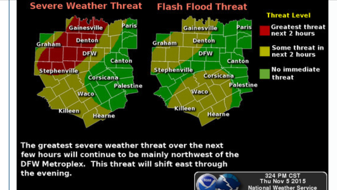
North Texas Tornado watch issued: Increasing likely-hood of a severe weather outbreak
page: 2share:
a reply to: TechniXcality
I'm only a little further east on I20 from liveandlearn - any idea when the squall line will be past? I'm going out to my buddys land for some hunting tomorrow through the weekend and my wife wants a date night tonight...
I'm wondering if it will be a go out or order in type of night?
Cheers for your informative / helpful thread!
a reply to: SonOfThor
Yes no problem, the line is still developing and we can give a round about time based on model data between 6pm - 9pm ft.worth should be on the western periphery. So by 9pm according to data you will be clear, but that is not absolute as radar trends are ever evolving.
To answer your question, i would stay in with the Mrs. tonight stay safe brother
edit on 5-11-2015 by TechniXcality because: (no reason
given)
a reply to: TechniXcality
As i expected earlier the cell that was in southwest Ft. Worth which is now in north east Ft. Worth is now Tornado warned! THATS YOU GRAPEVINE moving north east towards south east Denton county NWS is preparing statement TAKE COVER !
As i expected earlier the cell that was in southwest Ft. Worth which is now in north east Ft. Worth is now Tornado warned! THATS YOU GRAPEVINE moving north east towards south east Denton county NWS is preparing statement TAKE COVER !
edit on 5-11-2015 by TechniXcality because: (no reason given)
Funnel cloud North east F W with brief touchdown. moving toward Colleyville and southlake. Daughter is in Colleyville
originally posted by: iunlimited491
S&F, OP.
I'm posting the TVN (LiveStormChasing) Link,
if anybody would like to follow these storms visually.
^^ I definitely recommend checking it out.
I guess we'll have to wait and see what happens.
All the Best to those in it's path.
I will be following.
S&F to the OP too.
Dude, you are like my hero for posting this live link url, I didn't even know it existed! (Weather dumb Brit here)
Fyi Doug Drace seems to be closest to the main system atm.
Stay safe y'all!
Ps I did live in Dallas for a year
a reply to: liveandlearn
the center of circulation appears to be to the north west(moving north east) of her she needs to take cover, but i do believe she is safe.
the center of circulation appears to be to the north west(moving north east) of her she needs to take cover, but i do believe she is safe.
edit
on 5-11-2015 by TechniXcality because: (no reason given)
a reply to: liveandlearn
From NWS:
From NWS:
Tornado Warning
TORNADO WARNING
TXC439-052245-
/O.NEW.KFWD.TO.W.0110.151105T2217Z-151105T2245Z/
BULLETIN - EAS ACTIVATION REQUESTED
TORNADO WARNING
NATIONAL WEATHER SERVICE FORT WORTH TX
417 PM CST THU NOV 5 2015
THE NATIONAL WEATHER SERVICE IN FORT WORTH HAS ISSUED A
* TORNADO WARNING FOR...
NORTHEASTERN TARRANT COUNTY IN NORTH CENTRAL TEXAS...
* UNTIL 445 PM CST
* AT 417 PM CST...A CONFIRMED TORNADO WAS LOCATED OVER NORTH RICHLAND
HILLS...OR OVER WATAUGA...MOVING NORTHEAST AT 40 MPH.
HAZARD...DAMAGING TORNADO.
SOURCE...WEATHER SPOTTERS CONFIRMED TORNADO.
IMPACT...FLYING DEBRIS WILL BE DANGEROUS TO THOSE CAUGHT WITHOUT
SHELTER. MOBILE HOMES WILL BE DAMAGED OR DESTROYED.
DAMAGE TO ROOFS...WINDOWS AND VEHICLES WILL OCCUR. TREE
DAMAGE IS LIKELY.
* THE TORNADO WILL BE NEAR...
SOUTHLAKE...TROPHY CLUB AND ROANOKE AROUND 430 PM CST.
GRAPEVINE AROUND 435 PM CST.
FLOWER MOUND AROUND 440 PM CST.
OTHER LOCATIONS IMPACTED BY THIS TORNADIC THUNDERSTORM INCLUDE
WESTLAKE.
THIS INCLUDES INTERSTATE 820 BETWEEN MILE MARKERS 21 AND 22.
PRECAUTIONARY/PREPAREDNESS ACTIONS...
TO REPEAT...A TORNADO IS ON THE GROUND. TAKE COVER NOW! MOVE TO A
BASEMENT OR AN INTERIOR ROOM ON THE LOWEST FLOOR OF A STURDY
BUILDING. AVOID WINDOWS. IF YOU ARE OUTDOORS...IN A MOBILE HOME...OR
IN A VEHICLE...MOVE TO THE CLOSEST SUBSTANTIAL SHELTER AND PROTECT
YOURSELF FROM FLYING DEBRIS.
&&
LAT...LON 3298 9703 3289 9706 3284 9712 3284 9725
3289 9731 3299 9726
TIME...MOT...LOC 2217Z 223DEG 37KT 3288 9723
TORNADO...OBSERVED
HAIL...0.00IN
$$
CAVANAUGH
a reply to: TechniXcality
Thanks brother, you too. She called me freaking out while she was driving home from work cause she heard Tarrant county getting tornado warned, but thanks to your quick updates I was able to tell her it is well north of her.
Hopefully it isn't too bad out there in about an hour when I head home.
Thanks brother, you too. She called me freaking out while she was driving home from work cause she heard Tarrant county getting tornado warned, but thanks to your quick updates I was able to tell her it is well north of her.
Hopefully it isn't too bad out there in about an hour when I head home.
a reply to: Rexamus
Hey man if you are near Decatur it is now tornado warned! TAKE COVER
NWS warning
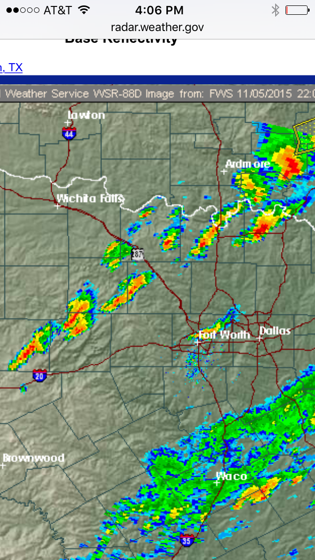
RADAR PICTURE:
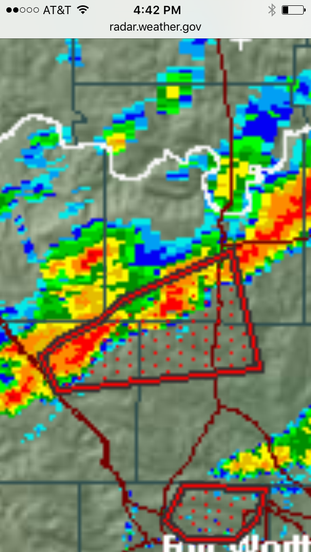
Everyone in north Texas needs to be prepared as stated earlier the atmosphere is very unstable and high wind shear is creating an extremely favorable environment for tornadoes. Stay tuned be safe
Hey man if you are near Decatur it is now tornado warned! TAKE COVER
NWS warning
Tornado Warning
TORNADO WARNING
TXC097-121-497-052300-
/O.NEW.KFWD.TO.W.0111.151105T2233Z-151105T2300Z/
BULLETIN - EAS ACTIVATION REQUESTED
TORNADO WARNING
NATIONAL WEATHER SERVICE FORT WORTH TX
433 PM CST THU NOV 5 2015
THE NATIONAL WEATHER SERVICE IN FORT WORTH HAS ISSUED A
* TORNADO WARNING FOR...
NORTHEASTERN WISE COUNTY IN NORTH CENTRAL TEXAS...
NORTHWESTERN DENTON COUNTY IN NORTH CENTRAL TEXAS...
SOUTHWESTERN COOKE COUNTY IN NORTH CENTRAL TEXAS...
* UNTIL 500 PM CST
* AT 433 PM CST...A SEVERE THUNDERSTORM CAPABLE OF PRODUCING A
TORNADO WAS LOCATED 7 MILES NORTHEAST OF DECATUR...MOVING NORTHEAST
AT 45 MPH.
HAZARD...TORNADO AND QUARTER SIZE HAIL.
SOURCE...RADAR INDICATED ROTATION.
IMPACT...FLYING DEBRIS WILL BE DANGEROUS TO THOSE CAUGHT WITHOUT
SHELTER. MOBILE HOMES WILL BE DAMAGED OR DESTROYED.
DAMAGE TO ROOFS...WINDOWS AND VEHICLES WILL OCCUR. TREE
DAMAGE IS LIKELY.
* THIS DANGEROUS STORM WILL BE NEAR...
SANGER AROUND 500 PM CST.
OTHER LOCATIONS IMPACTED BY THIS TORNADIC THUNDERSTORM INCLUDE VALLEY
VIEW.
THIS INCLUDES THE FOLLOWING INTERSTATES...
INTERSTATE 35 BETWEEN MILE MARKERS 473 AND 495.
INTERSTATE 30 BETWEEN MILE MARKERS 473 AND 495.
PRECAUTIONARY/PREPAREDNESS ACTIONS...
TAKE COVER NOW! MOVE TO A BASEMENT OR AN INTERIOR ROOM ON THE LOWEST
FLOOR OF A STURDY BUILDING. AVOID WINDOWS. IF YOU ARE OUTDOORS...IN A
MOBILE HOME...OR IN A VEHICLE...MOVE TO THE CLOSEST SUBSTANTIAL
SHELTER AND PROTECT YOURSELF FROM FLYING DEBRIS.
&&
LAT...LON 3330 9705 3324 9760 3334 9764 3338 9759
3343 9749 3349 9742 3362 9713
TIME...MOT...LOC 2233Z 246DEG 39KT 3333 9753
TORNADO...RADAR INDICATED
HAIL...1.00IN
$$
CAVANAUGH
RADAR PICTURE:
Everyone in north Texas needs to be prepared as stated earlier the atmosphere is very unstable and high wind shear is creating an extremely favorable environment for tornadoes. Stay tuned be safe
edit on 5-11-2015 by TechniXcality because: (no reason given)
a reply to: liveandlearn
Pictures out of Northeast Tarrant county near north Richland hills .
Please update us on her safety.
thoughts and prayers need to go out to the southern plains tonight.
Pictures out of Northeast Tarrant county near north Richland hills .
Please update us on her safety.
thoughts and prayers need to go out to the southern plains tonight.
edit on 5-11-2015 by TechniXcality because: (no reason given)
a reply to: TechniXcality
My DFW Scanner app is reporting major damage and a roof blown off of a 3 story building at 4500 Mercantile Dr. in Ft. Worth...
Also - based on the radar anyone up near Decatur needs to take cover IMMEDIATELY.
Please everyone keep us posted on your safety and take care!
My DFW Scanner app is reporting major damage and a roof blown off of a 3 story building at 4500 Mercantile Dr. in Ft. Worth...
Also - based on the radar anyone up near Decatur needs to take cover IMMEDIATELY.
Please everyone keep us posted on your safety and take care!
a reply to: SonOfThor
If interested notice how the storm that produced the tornado in north east fort worth has fallen apart.
That is because as it got closer to the storms off to the west; the energy and instability in the atmosphere is being used by the storms to the west and it was sheared apart.
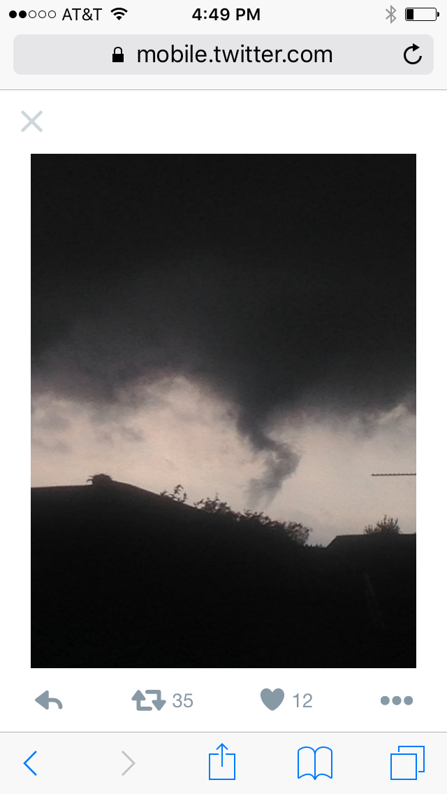
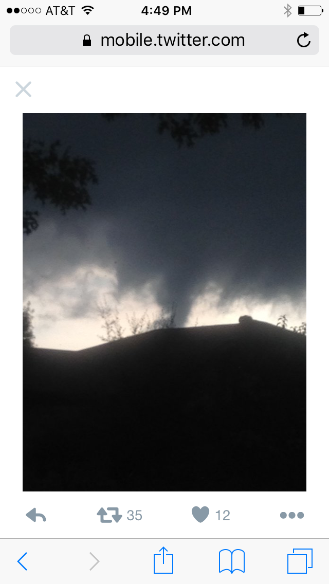
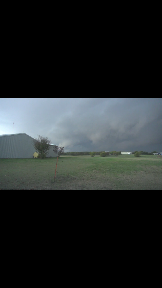
Now when we talk about a "wall cloud" this is a picture of one currently near Decatur, if you are anywhere near this please take cover!
Everyone else just because the sun is out and it seems fine we are NOT out from the gun do not be fooled this set up is not your typical fall severe weather outbreak.
Will continue to update..
If interested notice how the storm that produced the tornado in north east fort worth has fallen apart.
That is because as it got closer to the storms off to the west; the energy and instability in the atmosphere is being used by the storms to the west and it was sheared apart.
Now when we talk about a "wall cloud" this is a picture of one currently near Decatur, if you are anywhere near this please take cover!
Everyone else just because the sun is out and it seems fine we are NOT out from the gun do not be fooled this set up is not your typical fall severe weather outbreak.
Will continue to update..
a reply to: TechniXcality
I left a message when original notification included her area. She hasn't returned the call but not unusual for her.
I will check again in a bit.
Really appreciate your updates. Channel hopping right now. Really wasn't expecting this tonight. Looks like northern areas right now.
Just heard one injured at gas station at I 35w and 28th in north Tarrant.
a reply to: TechniXcality
foul language but this is video of the tornado in north east fort worth earlier
foul language but this is video of the tornado in north east fort worth earlier
a reply to: liveandlearn
These storms will effect all of us, as they congeal a little later, Please be safe, the reason i made this thread is because the weather services and channels were not advertising what i was seeing in the models, and current conditions its better to be right and safe, than wrong and dead. Anyway keep us updated
These storms will effect all of us, as they congeal a little later, Please be safe, the reason i made this thread is because the weather services and channels were not advertising what i was seeing in the models, and current conditions its better to be right and safe, than wrong and dead. Anyway keep us updated
Brandon Clements stream is crystal clear, and a vortex looks imminent
Edit : well his side cams are jittery, he's finding a place to turn into and face the storm now
Edit : well his side cams are jittery, he's finding a place to turn into and face the storm now
edit on 5/11/15 by OpenEars123 because: (no
reason given)
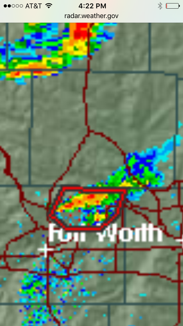
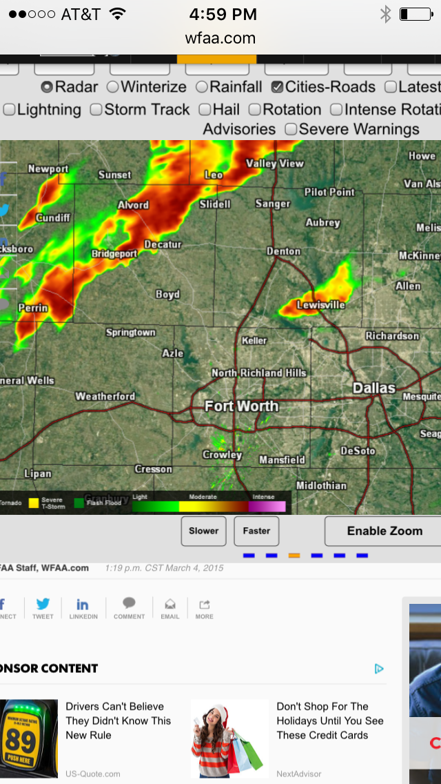
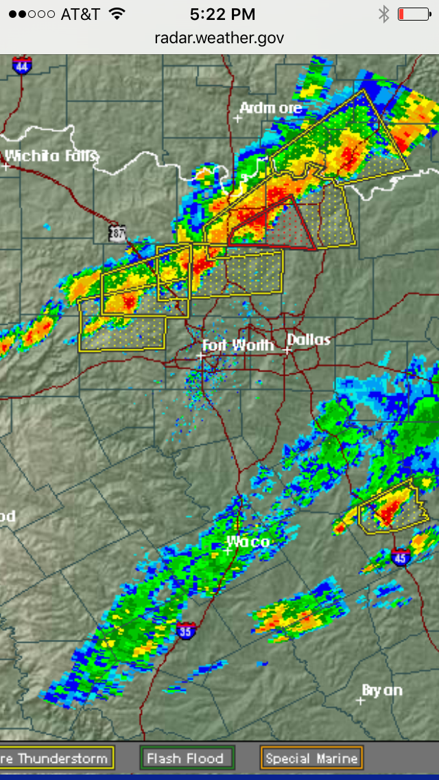
Also something to note these storms are now taking a more eastward direction this typical of "right turning super-cells" when super cells starting
rotating they tend to take a right turn. here's the current radar picture showing that turn.
a reply to: OpenEars123
Brandon is located in Denton Texas
Everyone needs to watch this, if you are in Denton TAKE cover as stated these storms are taking a right turn collin county which is me is next this is a deadly situation the sirens are going off everyone stay safe..
NWS Tornado Warning Denton Texas:
Brandon is located in Denton Texas
Everyone needs to watch this, if you are in Denton TAKE cover as stated these storms are taking a right turn collin county which is me is next this is a deadly situation the sirens are going off everyone stay safe..
NWS Tornado Warning Denton Texas:
Tornado Warning
TORNADO WARNING
TXC121-052345-
/O.NEW.KFWD.TO.W.0113.151105T2321Z-151105T2345Z/
BULLETIN - EAS ACTIVATION REQUESTED
TORNADO WARNING
NATIONAL WEATHER SERVICE FORT WORTH TX
521 PM CST THU NOV 5 2015
THE NATIONAL WEATHER SERVICE IN FORT WORTH HAS ISSUED A
* TORNADO WARNING FOR...
CENTRAL DENTON COUNTY IN NORTH CENTRAL TEXAS...
* UNTIL 545 PM CST
* AT 521 PM CST...A SEVERE THUNDERSTORM CAPABLE OF PRODUCING A
TORNADO WAS LOCATED NEAR KRUM...OR 10 MILES WEST OF DENTON...MOVING
EAST AT 45 MPH.
HAZARD...TORNADO AND GOLF BALL SIZE HAIL.
SOURCE...RADAR INDICATED ROTATION.
IMPACT...FLYING DEBRIS WILL BE DANGEROUS TO THOSE CAUGHT WITHOUT
SHELTER. MOBILE HOMES WILL BE DAMAGED OR DESTROYED.
DAMAGE TO ROOFS...WINDOWS AND VEHICLES WILL OCCUR. TREE
DAMAGE IS LIKELY.
* THIS DANGEROUS STORM WILL BE NEAR...
KRUM AND ARGYLE AROUND 530 PM CST.
CORINTH AROUND 535 PM CST.
SHADY SHORES AROUND 540 PM CST.
FRISCO...DENTON...AUBREY...KRUGERVILLE...CROSS ROADS AND RAY
ROBERTS PARK ISLE DU BOIS AROUND 545 PM CST.
OTHER LOCATIONS IMPACTED BY THIS TORNADIC THUNDERSTORM INCLUDE
PONDER...OAK POINT AND LINCOLN PARK.
THIS INCLUDES THE FOLLOWING INTERSTATES...
INTERSTATE 35 BETWEEN MILE MARKERS 468 AND 476.
INTERSTATE 35W BETWEEN MILE MARKERS 78 AND 85.
INTERSTATE 35E BETWEEN MILE MARKERS 458 AND 466.
INTERSTATE 30 BETWEEN MILE MARKERS 468 AND 476.
PRECAUTIONARY/PREPAREDNESS ACTIONS...
TAKE COVER NOW! MOVE TO A BASEMENT OR AN INTERIOR ROOM ON THE LOWEST
FLOOR OF A STURDY BUILDING. AVOID WINDOWS. IF YOU ARE OUTDOORS...IN A
MOBILE HOME...OR IN A VEHICLE...MOVE TO THE CLOSEST SUBSTANTIAL
SHELTER AND PROTECT YOURSELF FROM FLYING DEBRIS.
&&
LAT...LON 3341 9691 3342 9686 3340 9684 3316 9684
3310 9737 3318 9740 3328 9739 3342 9692
TIME...MOT...LOC 2321Z 256DEG 41KT 3321 9731
TORNADO...RADAR INDICATED
HAIL...1.75IN
$$
AJS
Live feed from the areas under the tornado warning
KHOU Live Helicopter footage
Great thread BTW
S&F
KHOU Live Helicopter footage
Great thread BTW
S&F
edit on 11/5/2015 by Neysa because: (no reason given)
new topics
-
Ditching physical money
History: 1 hours ago -
One Flame Throwing Robot Dog for Christmas Please!
Weaponry: 1 hours ago -
Don't take advantage of people just because it seems easy it will backfire
Rant: 2 hours ago -
VirginOfGrand says hello
Introductions: 2 hours ago -
Should Biden Replace Harris With AOC On the 2024 Democrat Ticket?
2024 Elections: 3 hours ago -
University student disciplined after saying veganism is wrong and gender fluidity is stupid
Education and Media: 5 hours ago -
Geddy Lee in Conversation with Alex Lifeson - My Effin’ Life
People: 7 hours ago -
God lived as a Devil Dog.
Short Stories: 7 hours ago -
Police clash with St George’s Day protesters at central London rally
Social Issues and Civil Unrest: 8 hours ago -
TLDR post about ATS and why I love it and hope we all stay together somewhere
General Chit Chat: 9 hours ago
top topics
-
Hate makes for strange bedfellows
US Political Madness: 11 hours ago, 18 flags -
Who guards the guards
US Political Madness: 14 hours ago, 13 flags -
University student disciplined after saying veganism is wrong and gender fluidity is stupid
Education and Media: 5 hours ago, 11 flags -
Police clash with St George’s Day protesters at central London rally
Social Issues and Civil Unrest: 8 hours ago, 8 flags -
TLDR post about ATS and why I love it and hope we all stay together somewhere
General Chit Chat: 9 hours ago, 7 flags -
Should Biden Replace Harris With AOC On the 2024 Democrat Ticket?
2024 Elections: 3 hours ago, 5 flags -
Has Tesla manipulated data logs to cover up auto pilot crash?
Automotive Discussion: 16 hours ago, 3 flags -
One Flame Throwing Robot Dog for Christmas Please!
Weaponry: 1 hours ago, 2 flags -
Don't take advantage of people just because it seems easy it will backfire
Rant: 2 hours ago, 2 flags -
Geddy Lee in Conversation with Alex Lifeson - My Effin’ Life
People: 7 hours ago, 2 flags
active topics
-
VirginOfGrand says hello
Introductions • 1 • : VirginOfGrand -
Candidate TRUMP Now Has Crazy Judge JUAN MERCHAN After Him - The Stormy Daniels Hush-Money Case.
Political Conspiracies • 740 • : matafuchs -
Should Biden Replace Harris With AOC On the 2024 Democrat Ticket?
2024 Elections • 33 • : BernnieJGato -
Gold and silver prices....woo hoo
History • 84 • : annonentity -
The Democrats Take Control the House - Look what happened while you were sleeping
US Political Madness • 108 • : Zanti Misfit -
Ditching physical money
History • 7 • : TheMisguidedAngel -
BREAKING! Another Bridge Hit by a barge #3 this week.
Mainstream News • 110 • : RookQueen2 -
One Flame Throwing Robot Dog for Christmas Please!
Weaponry • 4 • : Dalamax -
15 Unhealthiest Sodas On The Market
Health & Wellness • 40 • : Freeborn -
Remember These Attacks When President Trump 2.0 Retribution-Justice Commences.
2024 Elections • 47 • : Zanti Misfit