It looks like you're using an Ad Blocker.
Please white-list or disable AboveTopSecret.com in your ad-blocking tool.
Thank you.
Some features of ATS will be disabled while you continue to use an ad-blocker.

Louisiana Slipping Away
page: 114
share:
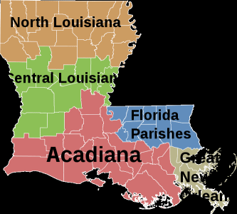
If you've looked at a map of the United States, you might have noticed a boot-shaped state by the name of Louisiana. This is where New Orleans is
located, as well as the delta of the mighty Mississippi River. It looks something like this:
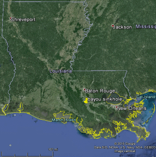
Now, a lot of this land is swampy. It's still counted as 'land' by the USGS and even Google:
The problem?
It doesn't look like that anymore (***A note on this source, there's a questionable image further on - a piece of artwork nearer the bottom that is obscene***):
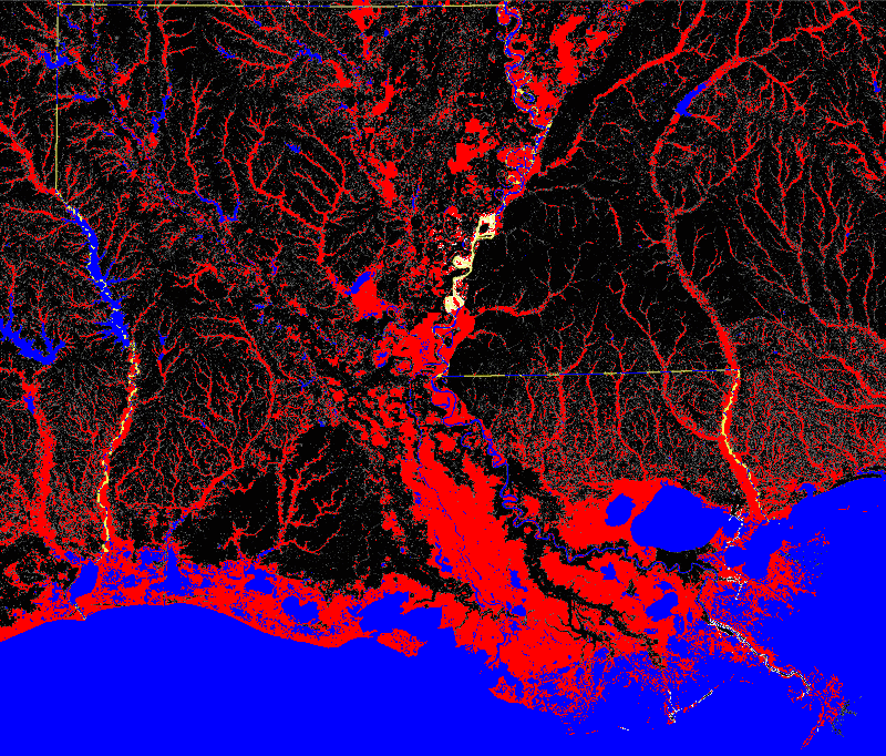
Red is 'land' that isn't walkable (also not known as 'land'). Black is walkable. Blue is recognized as water.
So, what's caused this loss? Well, there are a number of reasons. One is that the Mississippi isn't silting up the area as much as it used to - in large part due to human engineering. Another is the inundation by the rising sea levels and weather events like hurricanes Katrina and Rita.
However, a large culprit is the oil & gas industry - the extraction of these resources contributes to land subsidence, along with the multitude of canals, chemical spills, etc.
Yet, why hasn't the map changed, when we have better and more accurate detail now than ever before?
Another individual said of a Louisiana map change:
Scare people, huh?
Why indeed might such a thing scare people.
Now, a lot of this land is swampy. It's still counted as 'land' by the USGS and even Google:
The problem?
It doesn't look like that anymore (***A note on this source, there's a questionable image further on - a piece of artwork nearer the bottom that is obscene***):
According to the U.S.G.S., the state lost just under 1,900 square miles of land between 1932 and 2000.
Red is 'land' that isn't walkable (also not known as 'land'). Black is walkable. Blue is recognized as water.
So, what's caused this loss? Well, there are a number of reasons. One is that the Mississippi isn't silting up the area as much as it used to - in large part due to human engineering. Another is the inundation by the rising sea levels and weather events like hurricanes Katrina and Rita.
However, a large culprit is the oil & gas industry - the extraction of these resources contributes to land subsidence, along with the multitude of canals, chemical spills, etc.
“It’s crystal clear, according to every single scientific study, including studies done by the [oil and gas] industry itself, that industry activities are responsible for a substantial part of the land loss,” said John M. Barry ... former vice president of the Southeast Louisiana Flood Protection Authority-East (SLFPA-E), the government body charged with overseeing the flood protection system covering most of metro New Orleans.
Yet, why hasn't the map changed, when we have better and more accurate detail now than ever before?
I called both D. Phil Turnipseed of the National Wetlands Research Center, and Jerome Zeringue, the chair of the C.P.R.A. board and Jindal’s executive assistant for coastal activities, who acknowledged that the state’s current map is deceptive. Of the existing map, Zeringue told me, “People get a false sense of security, they see these topographic maps, they see these solid platforms of marsh that aren’t there… it’s a false reality.” But both officials declined to publicly advocate for a change, which may be legally impossible. Eighty percent of Louisiana’s coast is privately owned.
Another individual said of a Louisiana map change:
John Barry, the author and instigator of the lawsuit against the oil companies, he was quick to say, “It will never happen.”
He recalled a meeting he attended when he was still on the levee board. It was considering a proposal to install markers around New Orleans showing how high the floodwaters rose during Katrina. Some of the markers would go on levees.
“They came to us because you can’t do anything on the levee without our permission,” recalled Barry, who said the board was supportive of the plan. “There was a guy there from the Business Council [of New Orleans]. He said, ‘This is a bad idea whose time should never come.’ He was worried you were going to scare people.”
Scare people, huh?
Why indeed might such a thing scare people.
a reply to: Greven
They absolutely should do this. Having just been in the middle of the South Carolina flooding, I think we all could have used a reminder of how high the water can go in certain areas. The last flood here was in 1973, and a lot had been forgotten in that time.
Our situation was bizarre and unusual. Louisiana is a whole different situation and they should be doing everything they can to keep their population aware of what can happen under the right circumstances.
The power of water is scary, that's why!
originally posted by: Marionette
a reply to: Greven
They absolutely should do this. Having just been in the middle of the South Carolina flooding, I think we all could have used a reminder of how high the water can go in certain areas. The last flood here was in 1973, and a lot had been forgotten in that time.
Our situation was bizarre and unusual. Louisiana is a whole different situation and they should be doing everything they can to keep their population aware of what can happen under the right circumstances.
The power of water is scary, that's why!
In other parts of the USA, there were home owners who were taken to court simply because they put up a sign on their front lawn saying "flood plain begins 40 meters along this road --->"
The property developers were furious that the one sign would cost them sales
a reply to: Greven
Can someone explain to me how the sea level rises only in certain areas of the world, but not most areas? Thanks.
That was a rhetorical question. I skimmed the site, and I think it is a load of BS. The black and white maps are clearly adulterated. Funny how there are rivers and estuaries all over the place where there once were none at all. Looks like some photoshop work occurred.
Also, the article says the land is sinking, not that the ocean is rising. I'm sure the global climate warming change alarmists are exploiting this BS to the hilt.
edit on 15-10-2015 by HighDesertPatriot because: give me a break
a reply to: HighDesertPatriot
The emphasis was not only on sea level rise - in either my post or the article.
It seems like you need to work on your skimming skills, because it doesn't look like you read my post or the article at all and simply jumped to a conclusion along with a rant.
Also, while you might think it is a rhetorical question - it isn't. Sea levels are relative - they are literally defined as the mean level of the ocean at a place. Therefore, if one place is subsiding and another is rising, they have vastly different rates of sea level change.
Consider the Gulf Stream - it naturally reduces the sea level on the East Coast of the U.S. by feet in some areas. If that current were to stall out, then sea levels would rise rapidly, there.
Further, there are various gravitational anomalies around the world that pull water down or let it rise. Also, because the Earth rotates, water accumulates near the equator more than near the poles.
e: One other thing - go look at Google Earth, which has satellite imagery of the state. Take a tour. Look at elevation data, while you're at it. Red does not indicate lost to sea, but land that isn't walkable. You could infer that coastal areas are basically lost to the sea, but more interior areas are swampland.
edit on 17Thu, 15 Oct 2015 17:44:43 -0500America/ChicagovAmerica/Chicago10 by Greven because: (no reason
given)
new topics
-
VirginOfGrand says hello
Introductions: 37 minutes ago -
Should Biden Replace Harris With AOC On the 2024 Democrat Ticket?
2024 Elections: 1 hours ago -
University student disciplined after saying veganism is wrong and gender fluidity is stupid
Education and Media: 3 hours ago -
Geddy Lee in Conversation with Alex Lifeson - My Effin’ Life
People: 4 hours ago -
God lived as a Devil Dog.
Short Stories: 5 hours ago -
Police clash with St George’s Day protesters at central London rally
Social Issues and Civil Unrest: 6 hours ago -
TLDR post about ATS and why I love it and hope we all stay together somewhere
General Chit Chat: 7 hours ago -
Hate makes for strange bedfellows
US Political Madness: 9 hours ago
top topics
-
Hate makes for strange bedfellows
US Political Madness: 9 hours ago, 17 flags -
Who guards the guards
US Political Madness: 12 hours ago, 13 flags -
Police clash with St George’s Day protesters at central London rally
Social Issues and Civil Unrest: 6 hours ago, 8 flags -
TLDR post about ATS and why I love it and hope we all stay together somewhere
General Chit Chat: 7 hours ago, 6 flags -
University student disciplined after saying veganism is wrong and gender fluidity is stupid
Education and Media: 3 hours ago, 5 flags -
Should Biden Replace Harris With AOC On the 2024 Democrat Ticket?
2024 Elections: 1 hours ago, 4 flags -
Has Tesla manipulated data logs to cover up auto pilot crash?
Automotive Discussion: 14 hours ago, 2 flags -
Geddy Lee in Conversation with Alex Lifeson - My Effin’ Life
People: 4 hours ago, 2 flags -
God lived as a Devil Dog.
Short Stories: 5 hours ago, 2 flags -
VirginOfGrand says hello
Introductions: 37 minutes ago, 0 flags
14