It looks like you're using an Ad Blocker.
Please white-list or disable AboveTopSecret.com in your ad-blocking tool.
Thank you.
Some features of ATS will be disabled while you continue to use an ad-blocker.

911myths.com : WHY FAKING >73° BANK-ANGLES for a NoC FLYING PLANE.?
page: 33share:
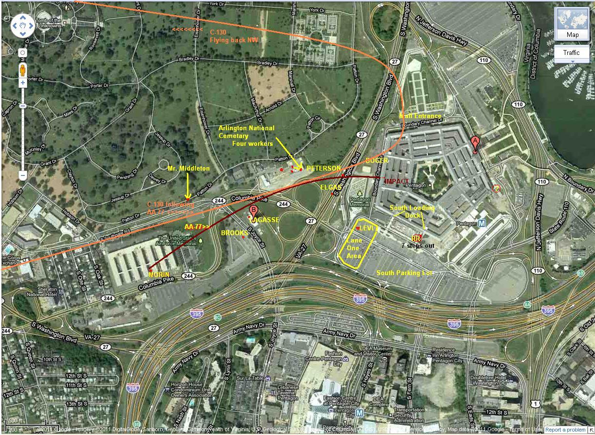
A quick reminder : The official story's flight path is promoted as flying South of the CITGO gas station in a straight line to the impact point at
column 14, by all those Institutes and Agencies, and
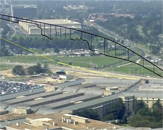
That's from the moment Flight 77 reached the western corner of the first of the Navy Annex its eight Wings buildings, just after it passed the south side of the Sheraton Hotel and passed with its left wing tip over Edward Paik's car repair shop its front office, where through its window Edward was looking up over Columbia Pike.
And there the VDOT radio mast on the right side of the Pike was in the way, so the plane veered slightly to the left to avoid flying into the high steel construction of that radio mast. And had to bank around the north side of the CITGO gas station, and banked back to the right to State Route 27, where it leveled off just right of the two low trees along its northbound lane, and flew into column 14 of the Pentagon west wall under a few degrees right wing tip-up angle. Its fuselage hit thus under a lot bigger angle than the officially proposed angle. More like 80 to 85 degrees to the wall. And the plane debris did not penetrate further than the back of Ring E of Wedge 1. The exact same portion that later (around 10 o'clock) caved in on all the plane debris that laid there.
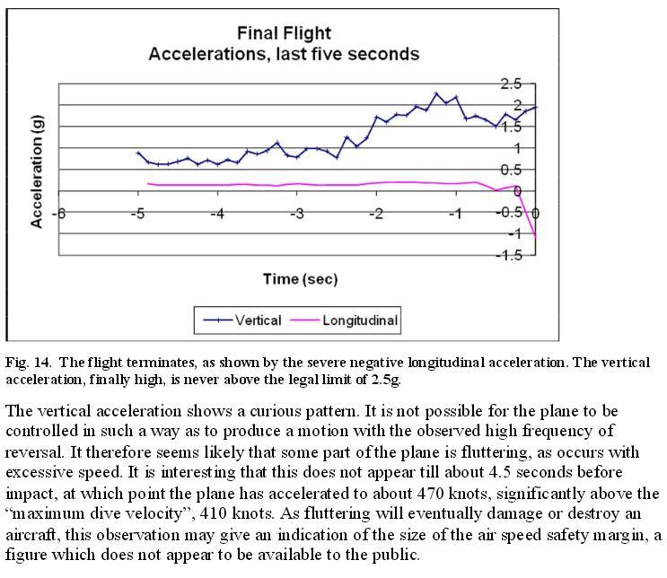
The plane flew much slower than the official speed as extracted from the altered last 5 seconds of flight time, since we have now about 11 eyewitnesses who all say that the plane veered, or i.o.w. banked. Four of them say at an angle of no more than 35 degrees. Which, combined with the calculated turn radius, can only result in a very small couple of airspeeds, all around circa 230 mph and not the 500 to 530 mph end speed as deducted from the recovered FDR (which was lost for a few days from the FBI office, and then turned up miraculously in another FBI office, they lost track of it for a few days only, that's enough however to alter the last 5 flight seconds digital recorded data. That's not a difficult job at all, it's an argument that is used too much without solid evidence that it can't be done. Because it can be done easily, especially if you have it laying dormant for a long time already, waiting to be inserted or even switched or swapped.
When I compare what is quoted in the article, as his own description of his position at the CITGO gas station on 9/11 at 10:37 a.m., and the text lines under the photo of the two troopers, there's something important to discover.
The one spot shown in the photo, and the one quoted, are mutually exclusive.
Their descriptions and positions do not fit each other, it's a discrepancy of about 250 meters.
has in its recovered Flight Data Recorder (FDR)
NO BANK AT ALL
showing up in the last 5 data-seconds.
That's from the moment Flight 77 reached the western corner of the first of the Navy Annex its eight Wings buildings, just after it passed the south side of the Sheraton Hotel and passed with its left wing tip over Edward Paik's car repair shop its front office, where through its window Edward was looking up over Columbia Pike.
And there the VDOT radio mast on the right side of the Pike was in the way, so the plane veered slightly to the left to avoid flying into the high steel construction of that radio mast. And had to bank around the north side of the CITGO gas station, and banked back to the right to State Route 27, where it leveled off just right of the two low trees along its northbound lane, and flew into column 14 of the Pentagon west wall under a few degrees right wing tip-up angle. Its fuselage hit thus under a lot bigger angle than the officially proposed angle. More like 80 to 85 degrees to the wall. And the plane debris did not penetrate further than the back of Ring E of Wedge 1. The exact same portion that later (around 10 o'clock) caved in on all the plane debris that laid there.
The plane flew much slower than the official speed as extracted from the altered last 5 seconds of flight time, since we have now about 11 eyewitnesses who all say that the plane veered, or i.o.w. banked. Four of them say at an angle of no more than 35 degrees. Which, combined with the calculated turn radius, can only result in a very small couple of airspeeds, all around circa 230 mph and not the 500 to 530 mph end speed as deducted from the recovered FDR (which was lost for a few days from the FBI office, and then turned up miraculously in another FBI office, they lost track of it for a few days only, that's enough however to alter the last 5 flight seconds digital recorded data. That's not a difficult job at all, it's an argument that is used too much without solid evidence that it can't be done. Because it can be done easily, especially if you have it laying dormant for a long time already, waiting to be inserted or even switched or swapped.
When I compare what is quoted in the article, as his own description of his position at the CITGO gas station on 9/11 at 10:37 a.m., and the text lines under the photo of the two troopers, there's something important to discover.
The one spot shown in the photo, and the one quoted, are mutually exclusive.
Their descriptions and positions do not fit each other, it's a discrepancy of about 250 meters.
The 10 years later shot photo shows the two uniformed men standing along Columbia Pike's right-side grassy roadside, about 100 meters south of the new
erected 9/11-Airforce Memorial.
The CITGO however, is to that newly erected Air Force Memorial's north side, as seen from its photo position.
Thus, the photo is so to see shot by an official flight path believing reporter, in such a spot that it would identify where the SoC official flight path was.
Which is in TOTAL contradiction with where Wimbish said he was, when the plane its passage rocked his car, namely in front of the gas pumps.
We suppose at CITGO gas station. Because that's the only spot NEAR any Flight 77 flight path, that had GAS PUMPS on its property, AND where Wimbish his car could have been rocked by the wing vortexes of Flight 77.
I thought that by now about everyone and their mothers knew that a few witnesses (Terry Morin, Sean Boger) said that the plane flew about right through where now that memorial is situated, on the former parking behind the last Annex building.
In front of the former position of "the radio antenna" at top-center of the then Wing 8 roof, which Boger described as the point where he saw Flight 77 passing over when he first saw it).
Deb Anlauf was in her hotel room at the Annex side of the Sheraton Hotel, in one of the top floors of the Sheraton Hotel, and had this view of the plane flying right into her field of view :
Terry Morin : I was in between the 4th and the 5th Annex Wings and walked just out on the parking.
Sean Boger : it flew over the antenna situated in the middle of the 8th Wing roof.
Albert Hemphill : it flew over my right shoulder - - the east viewing conference room he was in was near the very north side of that 8th Wing top floor.
Flight 77 was flying at a 30 to 50 feet altitude above the 8th Annex Wing its H-shaped radio antenna, which was in 2001 situated about halfway the length of the back-facade of the former 8th Wing, the last, most eastern Wing from the now demolished, 8 Navy Annex buildings.
The spot where the two troopers are standing in that 10th anniversary photo, is at least 250 meters south of the southern canopy of the CITGO gas station.
If we belief the video interviews with Pentagon Police Sgt. Lagasse and Brooks, videotaped in 2006 by the CIT team (I still firmly do), where they both said that they are 100 % sure ( "bet my life on it" ) that the plane they saw pass them in front of their northerly looking eyes, flew north of the northern CITGO canopy.
Thus trooper Myrlin Wimbish Jr. stood, (just as we can check in the FOIA freed CITGO video, the same video in which we checked where Sgt Lagasse stood), in the parking spaces to the north, or eastern side of the northern CITGO canopy, with the hood of his police car pointing to the pumps there, when the plane flew nearly right over him. I remember a few cars seen standing there east and also north of the pumps in a few parking spaces there.
www.abovetopsecret.com...
Someone has to get that FOIA freed CITGO video up again from the original Judicial Watch source, that's the sharpest version, and check it for a parked Virginia State trooper car, parked in the vicinity of those northern pumps. Search for a VS Trooper car around the last seconds before you see that intense long thin flash reflected on the white surface of the Northern canopy ceiling.
Collect some ATS 9/11 forum fame...on the way in.
Thus, he could not have been where that reporter had let him been photographed for his 2011 10th anniversary article, and then that reporter himself added that they stood UNDER the flightpath. We call that a framed photo.
Meant to sow doubt.? But why then mention also the position near the pumps (plural) of trooper Myrlin Wimbish Jr (thus in the CITGO grounds), in the same article written by him.?
It seems more of a case of imprinted indoctrinated acceptance of the OS flight path, so many times repeated in those 10 years, that the reporter either didn't dare to go off the Official Story flight path positions, or he genuinely believed the OS explained flight path.
I contemplated on the only other solution, that Wimbish car stood on that same side of Columbia Pike where he and Middleton were photographed in 2011, with its hood pointing to the CITGO gas station 250 meters northwards situated.
But then Wimbish would NOT have used the words "gas pumpS" (the plural form); but "gas station" or "CITGO gas station" instead.
However, his printed words were :
So, if he really stood on 9/11 beside the Pike where he was photographed 10 years later together with trooper Middleton, he would have mentioned that he had to look sideways to see the plane coming at him, like this :
"and I'm looking SIDEWAYS at the plane coming toward me" or :
"and I'm looking to my left at the plane coming toward me" or :
"and I'm looking through my driver side window at the plane coming toward me".
REFERENCES
* American Society of Civil Engineers. The Pentagon Building Performance Report. Reston, Va.: ASCE, January 2003. [cited as ASCE Report],
911research.wtc7.net...
* Department of Defense, Office of the Inspector General. Health Care: DoD Medical Support to the Federal Response Plan. Report No. D-2002-087. 10 May 2002,
www.dodig.mil...
* The 9/11 Commission Report: Final Report of the National Commission on Terrorist Attacks upon the United States. New York: W, W. Norton & Company, 2004,
www.9-11commission.gov...
www.cfr.org...
Someone has to get that FOIA freed CITGO video up again from the original Judicial Watch source, that's the sharpest version, and check it for a parked Virginia State trooper car, parked in the vicinity of those northern pumps. Search for a VS Trooper car around the last seconds before you see that intense long thin flash reflected on the white surface of the Northern canopy ceiling.
Collect some ATS 9/11 forum fame...on the way in.
Thus, he could not have been where that reporter had let him been photographed for his 2011 10th anniversary article, and then that reporter himself added that they stood UNDER the flightpath. We call that a framed photo.
Meant to sow doubt.? But why then mention also the position near the pumps (plural) of trooper Myrlin Wimbish Jr (thus in the CITGO grounds), in the same article written by him.?
It seems more of a case of imprinted indoctrinated acceptance of the OS flight path, so many times repeated in those 10 years, that the reporter either didn't dare to go off the Official Story flight path positions, or he genuinely believed the OS explained flight path.
I contemplated on the only other solution, that Wimbish car stood on that same side of Columbia Pike where he and Middleton were photographed in 2011, with its hood pointing to the CITGO gas station 250 meters northwards situated.
But then Wimbish would NOT have used the words "gas pumpS" (the plural form); but "gas station" or "CITGO gas station" instead.
However, his printed words were :
]"My car was facing toward the gas pumpS and I'm looking at the plane coming toward me
So, if he really stood on 9/11 beside the Pike where he was photographed 10 years later together with trooper Middleton, he would have mentioned that he had to look sideways to see the plane coming at him, like this :
"and I'm looking SIDEWAYS at the plane coming toward me" or :
"and I'm looking to my left at the plane coming toward me" or :
"and I'm looking through my driver side window at the plane coming toward me".
REFERENCES
* American Society of Civil Engineers. The Pentagon Building Performance Report. Reston, Va.: ASCE, January 2003. [cited as ASCE Report],
911research.wtc7.net...
* Department of Defense, Office of the Inspector General. Health Care: DoD Medical Support to the Federal Response Plan. Report No. D-2002-087. 10 May 2002,
www.dodig.mil...
* The 9/11 Commission Report: Final Report of the National Commission on Terrorist Attacks upon the United States. New York: W, W. Norton & Company, 2004,
www.9-11commission.gov...
www.cfr.org...
2. www.washingtontimes.com...
That "driving by the Pentagon on patrol" activity description", that's quite different from the 10 years later interview, where he said he stood in his parked car, facing toward the gas pumps.
We assume of the CITGO gas station. Since there was no other one near that flight path.
3. A book by the Department of Defense : PENTAGON 9/11
By Alfred Goldberg et al.
Defense Studies Series
Historical Office
Office of the Secretary of Defense
Washington, D.C. * 2007
Search in books.google... with terms : Trooper Myrlin Wimbish :
www.google.com...
You find two links to this same above book, and two Congressional Record links, with no more than 18 words, non indicative of a veering or banking maneuver, about him in it.
Only one small note.
By - The Washington Times - Thursday, September 13, 2001
Virginia State Trooper Merlin Wimbish was driving by the Pentagon on patrol when he heard the explosion.
He was among the first to see an image now etched in the national consciousness: A commercial airplane in the control of terrorists had crashed into the west side of the Pentagon.
That "driving by the Pentagon on patrol" activity description", that's quite different from the 10 years later interview, where he said he stood in his parked car, facing toward the gas pumps.
We assume of the CITGO gas station. Since there was no other one near that flight path.
3. A book by the Department of Defense : PENTAGON 9/11
By Alfred Goldberg et al.
Defense Studies Series
Historical Office
Office of the Secretary of Defense
Washington, D.C. * 2007
Search in books.google... with terms : Trooper Myrlin Wimbish :
www.google.com...
You find two links to this same above book, and two Congressional Record links, with no more than 18 words, non indicative of a veering or banking maneuver, about him in it.
PENTAGON 9/11 : Notes to Pages 151 - 156
17. - - For rescue accounts by two Virginia state troopers see memos Trooper Myrlin Wimbish for 1st Sgt Richard S. Keevill, 23 Nov 01, Trooper Michael S. Middleton for Keevill, nd, Virginia State Police.
Only one small note.
I found the direct link to this 320 pages thick Defense Studies Series book online :
www.dtic.mil...
Pages 151-156 (PDF 177- /320)
Anybody who remembers how security cameras and their video-recorders worked in 2001 at important facilities such as the Pentagon, realizes that of course you could rewind the tape from that destroyed camera and view what had happened.
Not a word about such logical reaction.....
I posted once about a then still online report from a lieutenant-colonel who also ran to that CC video-room, and that he had re-winded that tape to check what had happened, then we never heard anything further from that colonel, pfttt, lost in, of course already in place, damage-control space.
www.dtic.mil...
Pages 151-156 (PDF 177- /320)
Defense Protective Service
The DPS, led by Chief John Jester, had responsibility for security and law enforcement on the Pentagon Reservation. - - snip - -
In his office about 600 feet from the crash site Jester thought the shaking and loud noise was caused by a heavy load of furniture on a pallet rolling over an uneven expansion joint. He heard someone yell, "We've been hit!" His first thought was "No, not here. It can't happen here". He looked out the window, saw
page 152
smoke, ran down the stairs to the Communications Center, and shouted, "Get a camera up there!" Some of the center's eight monitor screens mounted on a wall remained blank because the crash had destroyed the camera nearest the impact site and cut connectivity to others.(ref.11) One monitor came on automatically, showing debris and doors blown off their hinges in Corridor 5. Officer Jesse DeVaughn brought up an image from a camera at the Navy Annex that had zoomed in on the roiling red flames and smoke. Nesbitt thought he was looking at the nearby gas station on South Joyce Street (LT : CITGO), so when he called to notify the Arlington County Fire Department of reports that a plane had hit the Pentagon, he also reported a fire at the gas station. Nesbitt then refocused the Annex camera to clearly show a normal gas station scene and the blaze at the Pentagon.12
Anybody who remembers how security cameras and their video-recorders worked in 2001 at important facilities such as the Pentagon, realizes that of course you could rewind the tape from that destroyed camera and view what had happened.
Not a word about such logical reaction.....
I posted once about a then still online report from a lieutenant-colonel who also ran to that CC video-room, and that he had re-winded that tape to check what had happened, then we never heard anything further from that colonel, pfttt, lost in, of course already in place, damage-control space.
Page 159 (PDF 186/320) excerpt :
I would really like to see the photos made by Navy Petty Officer Kevin Rimrodt, and the aerial ones made from the helicopters. Why do we have the photo series of Ingersoll already from very early on, online, but I never heard about the Rimrodt photo series, nor his name.
Btw, you should also use the "ASCE Report" besides this above 320 page Defense Study :
American Society of Civil Engineers. The Pentagon Building Performance Report.
Reston, Va.:ASCE, January 2003. [cited as ASCE Report] :
ascelibrary.org...
Complete Book PDF (2,775 KB) , PAY only :
ascelibrary.org...
For FREE : 911research.wtc7.net...
The Pentagon building performance report. Includes bibliographical references.
ISBN 0-7844-0638-3. 1. Buildings—Blast effects. 2. Building, Bombproof.
This is a critique on said ASCE Report :
www.bibliotecapleyades.net...
Seeking to collect lasting visual evidence, an FBI agent asked for assistance from two combat photographers, Marine Corporal Jason Ingersoll and Navy Petty Officer Kevin Rimrodt, who took photographs of the damaged building, the debris field, the path of the plane, and also the crowds of people who gathered to watch, among whom it was thought there might be terrorists. When another hijacked airliner was thought to be on its way, the agent asked Ingersoll and Rimrodt to stand where they could photograph the incoming aircraft if it smashed into the building. The photographers watched as everyone fled, leaving them behind at an exposed site to wait for the next catastrophic strike. The all clear signal brought them special relief. Other photographers boarded helicopters to take aerial shots of the Pentagon.(ref.30)
I would really like to see the photos made by Navy Petty Officer Kevin Rimrodt, and the aerial ones made from the helicopters. Why do we have the photo series of Ingersoll already from very early on, online, but I never heard about the Rimrodt photo series, nor his name.
Btw, you should also use the "ASCE Report" besides this above 320 page Defense Study :
American Society of Civil Engineers. The Pentagon Building Performance Report.
Reston, Va.:ASCE, January 2003. [cited as ASCE Report] :
ascelibrary.org...
Complete Book PDF (2,775 KB) , PAY only :
ascelibrary.org...
For FREE : 911research.wtc7.net...
The Pentagon building performance report. Includes bibliographical references.
ISBN 0-7844-0638-3. 1. Buildings—Blast effects. 2. Building, Bombproof.
This is a critique on said ASCE Report :
www.bibliotecapleyades.net...
4. timesdispatch.mycapture.com...
Two photos that are the same as in the nr 1. article above, from the Sept, 2011 Richmond Times-Dispatch, but smaller :
photos.mycapture.com...
photos.mycapture.com...
I found a 760px X 525px, scaled to 600px X 414px, of the above last small photo :
Mike Middleton & Myrlin Wimbish standing south of the Air Force 9/11 Memorial.
They clearly stand under the official SoC flight path, even too far south to that proposed SoC-path.
Again, Myrlin's 2011 remark is VERY STRANGE INDEED when you look at this photo its accompanying text.
In 2011 Myrlin clearly explained he was at a gas station, with his car's hood towards the pumps, while watching the plane coming at him, and its wing vortexes rocked his car.
That's 250 meters further in the background, and 60 meter to the right, where the CITGO gas station is situated at Joyce Street.
It seems as if the 9/11 Damage Control Task Force already had passed before 2011.
And oversaw the implication of Myrlin Wimbish his two remarks (VEERED and IN FRONT OF THE PUMPS).
Two photos that are the same as in the nr 1. article above, from the Sept, 2011 Richmond Times-Dispatch, but smaller :
photos.mycapture.com...
Virginia State Trooper Mike Middleton (left), and Myrlin Wimbish (right) were among the first responders to the Pentagon on 9/11. They stand here along Columbia Pike in Arlington, just under the flight path of the plane that struck the Pentagon on 9/11. The Pentagon is visible behind them; just beyond is the US Capitol. Middleton was on I-66 and arrived 6 minutes after the crash, Wimbish was in his car on Columbia Pike when the jet flew directly over him, so close that his cruiser shook from the jet's shock wave.
photos.mycapture.com...
Virginia State Trooper Mike Middleton, and Myrlin Wimbish were among the first responders to the Pentagon on 9/11. They stand here along Columbia Pike in Arlington, just under the flight path of the plane that struck the Pentagon on 9/11. The Pentagon slightly visible behind them; at left is the Air Force memorial.
I found a 760px X 525px, scaled to 600px X 414px, of the above last small photo :
Mike Middleton & Myrlin Wimbish standing south of the Air Force 9/11 Memorial.
They clearly stand under the official SoC flight path, even too far south to that proposed SoC-path.
Again, Myrlin's 2011 remark is VERY STRANGE INDEED when you look at this photo its accompanying text.
In 2011 Myrlin clearly explained he was at a gas station, with his car's hood towards the pumps, while watching the plane coming at him, and its wing vortexes rocked his car.
That's 250 meters further in the background, and 60 meter to the right, where the CITGO gas station is situated at Joyce Street.
It seems as if the 9/11 Damage Control Task Force already had passed before 2011.
And oversaw the implication of Myrlin Wimbish his two remarks (VEERED and IN FRONT OF THE PUMPS).
Thus it's very strange indeed, that on the 14th memorial year, month and day, this SAME explicit description, as from the 2011 article in the Richmond
Times-Dispatch by Master Trooper Myrlin Wimbish is written down again, in an official Defense Magazine article in 2015 :
The Pentagon's Sept. 11 First Responder stories (page 1), written and published on Sept. 11, 2015 :
www.defensemedianetwork.com...
That's strange, in the 2015 article for a DEPARTMENT of DEFENSE MAGAZINE, Myrlin completely contradicts his 2011 photographed position under the official flight path. Now he comes damn close to Sgt Lagasse and Brooks their North of CITGO flight path as seen from the northern pumps at the CITGO.
The Pentagon's Sept. 11 First Responder stories (page 1), written and published on Sept. 11, 2015 :
www.defensemedianetwork.com...
In Arlington County Fire Department’s Engine 101, Fire Capt. Steve McCoy and his crew, traveling north on Interstate 395 for a training exercise in Crystal City, saw the plane bank sharply before disappearing over the horizon. As soon as they heard the explosion and saw the massive plume of smoke and fire, McCoy radioed the Arlington County Emergency Communications Center (ECC) and – already thinking of the World Trade Center attacks – advised that the FBI be notified of a possible terrorist attack.
A few miles to the west, on Route 267, Virginia State Trooper Mike Middleton, who had just pulled over a motorist to issue a citation, heard his colleague, Trooper Myrlin Wimbish, shouting excitedly over the radio that a plane had just crashed into the Pentagon. Wimbish had been refueling his patrol car within view of the Pentagon when Flight 77 hurtled overhead, so close that his car rocked in the turbulence of the plane its wake. Wimbish, like many other witnesses, later observed that the plane was accelerating as it struck the building.
That's strange, in the 2015 article for a DEPARTMENT of DEFENSE MAGAZINE, Myrlin completely contradicts his 2011 photographed position under the official flight path. Now he comes damn close to Sgt Lagasse and Brooks their North of CITGO flight path as seen from the northern pumps at the CITGO.
a reply to: LaBTop
Yea but the plane hit the Pentagon,
That's strange, in the 2015 article for a DEPARTMENT of DEFENSE MAGAZINE, Myrlin completely contradicts his 2011 photographed position under the official flight path. Now he comes damn close to Sgt Lagasse and Brooks their North of CITGO flight path as seen from the northern pumps at the CITGO.
Yea but the plane hit the Pentagon,
From the same article :
Middleton thus heard a second TREMENDOUS explosion when he was about 1 to 2 minutes or one mile away from the entry hole at Wedge-I its E-Ring outer facade column 15, in the west wall.
That's 4 to 5 minutes after Wimbish had shouted over the radio, that the plane had hit the Pentagon....STRANGE, I never read about such a tremendous SECOND explosion, but we have the photo of combat photographer, Marine Corporal Jason Ingersoll, who also photographed a second explosion just minutes after the plane impact, where we see a huge red and white hot explosion spitting out of the west wall its entry hole....which must be the one Middleton describes above. Perhaps a pair of welding or steel cutting gas tanks, one with Acetylene gas, one with oxygen gas.? But the renovation of Wedge-1 was completed, and Wedge-2 should start weeks later. All building materials were already taken outside. Such as the cable spools. That explosion came however from the inside.
The Jason Ingersoll photo :

IMPORTANT NOTE : DO you, the reader, think that the front of the MAXIMUM FLEXED UP wing-TIP of a B757 flying over 500 mph at about one meter above the grass, could have cut that light pole laying there on that guardrail.? When the distance from that max flexed-up wingtip front to the bottom of the jet engine nacelles is 5.5 meter , see my extensive post about it on the previous page 32 :
www.abovetopsecret.com... :
Well, I have to disappoint you, in fact, that cut light pole nr 4 lays not -on- that guardrail, but -behind- it, and its cut top points away from the photographer, thus that fact works out disproportional on its real length, it looks short, about 4 meters, but it is quite longer, see pole nr 4 in the below collage of 5 cut light poles.
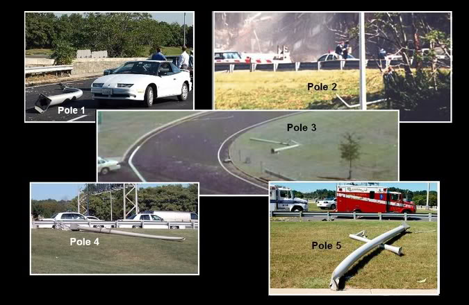
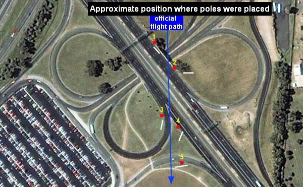
These are the 5 positions of the cut light poles, as seen from above :
However, when we look especially at pole nr 3 in that collage, it seems not cut at a higher height than about 4 meter from its base.
So, we must believe that that light pole nr 3 is at about a height of 4 meter high, cut by a 530 mph speeding wing tip of a B757-200, flexed upwards to its maximum.?
While its jet engine nacelles bottoms in such a situation then were used as plowshares, to plow through the Pentagon lawn at ONE AND A HALF METER DEEP. ???
Are there anywhere precise measurements registered about where exactly on their heights, these 5 light poles were cut by that B757 its wing tips.? I once saw an online calculation based on such values, to diagram the last part of the SoC flightpath, but how to find it back.?
Middleton set out immediately for the Pentagon. When he turned south onto Route 110, he heard another tremendous explosion, followed by a roiling column of smoke.
Middleton thus heard a second TREMENDOUS explosion when he was about 1 to 2 minutes or one mile away from the entry hole at Wedge-I its E-Ring outer facade column 15, in the west wall.
That's 4 to 5 minutes after Wimbish had shouted over the radio, that the plane had hit the Pentagon....STRANGE, I never read about such a tremendous SECOND explosion, but we have the photo of combat photographer, Marine Corporal Jason Ingersoll, who also photographed a second explosion just minutes after the plane impact, where we see a huge red and white hot explosion spitting out of the west wall its entry hole....which must be the one Middleton describes above. Perhaps a pair of welding or steel cutting gas tanks, one with Acetylene gas, one with oxygen gas.? But the renovation of Wedge-1 was completed, and Wedge-2 should start weeks later. All building materials were already taken outside. Such as the cable spools. That explosion came however from the inside.
The Jason Ingersoll photo :
IMPORTANT NOTE : DO you, the reader, think that the front of the MAXIMUM FLEXED UP wing-TIP of a B757 flying over 500 mph at about one meter above the grass, could have cut that light pole laying there on that guardrail.? When the distance from that max flexed-up wingtip front to the bottom of the jet engine nacelles is 5.5 meter , see my extensive post about it on the previous page 32 :
www.abovetopsecret.com... :
Fuselage diameter is 4.01m. Belly to ground 2.5m. Nacelle-bottom to belly 2m. Wheels on ground to belly bottom 2m.
Jet engine nacelle-bottom to wing TIP front line is about 4m when parked.
At 500+ mph another 1.5m on top of that is 5.5 meter. That's still 1.5m room under the nacelle-bottoms, to clear the 0.5 to 0.8 m high entrance-ramp guard rails under light pole 2, when that pole would have been cut at 7 m height.
The only trouble I see, is that the grassy area behind that guard rail, raised quite some meters up over that short distance of about 100 meters, towards the Pentagon's west wall.
And could a B757, even WITH autopilot functions on, be able to compensate those mere 1.5 meters left under its engine nacelles bottoms that fast, to clear that elevation difference.?
I really really doubt it.
Well, I have to disappoint you, in fact, that cut light pole nr 4 lays not -on- that guardrail, but -behind- it, and its cut top points away from the photographer, thus that fact works out disproportional on its real length, it looks short, about 4 meters, but it is quite longer, see pole nr 4 in the below collage of 5 cut light poles.
These are the 5 positions of the cut light poles, as seen from above :
However, when we look especially at pole nr 3 in that collage, it seems not cut at a higher height than about 4 meter from its base.
So, we must believe that that light pole nr 3 is at about a height of 4 meter high, cut by a 530 mph speeding wing tip of a B757-200, flexed upwards to its maximum.?
While its jet engine nacelles bottoms in such a situation then were used as plowshares, to plow through the Pentagon lawn at ONE AND A HALF METER DEEP. ???
Are there anywhere precise measurements registered about where exactly on their heights, these 5 light poles were cut by that B757 its wing tips.? I once saw an online calculation based on such values, to diagram the last part of the SoC flightpath, but how to find it back.?
Under one of the two 2011 photos is written that it took Middleton 6 minutes to reach the entry hole :
Are there any real Americans who are willing to phone Craig Collins, who wrote the Sept.11, 2015 article in that Defense Media Network its website. And ask him about the remarks from Wimbish and Middleton, if he got them from THEIR mouths. And if so, if he still has the tapes from those conversations.
EVEN more important, ask him if he still has the tapes from the interview(s) with Fire Capt. Steve McCoy and his crew.! In which they made the "sharp bank" remark regarding Flight 77.
Middleton was on I-66 and arrived 6 minutes after the crash, Wimbish was in his car on Columbia Pike when the jet flew directly over him,
Arlington County Police Department (ACPD) Cpl. Barry Foust, stopped at a traffic light less than two miles west of the Pentagon, saw the aircraft through his windshield. Three blocks away, at the intersection of Columbia Pike and South Wayne Street, ACPD Motorcycle Officer Richard Cox looked up to see, in the polished underside of the plane’s fuselage, the reflection of the buildings over which it was passing. Both officers then heard an explosion and saw a towering plume of smoke. Foust radioed: “We just had an airplane crash.” Cox was able to specify the Pentagon as the site of impact.
Are there any real Americans who are willing to phone Craig Collins, who wrote the Sept.11, 2015 article in that Defense Media Network its website. And ask him about the remarks from Wimbish and Middleton, if he got them from THEIR mouths. And if so, if he still has the tapes from those conversations.
EVEN more important, ask him if he still has the tapes from the interview(s) with Fire Capt. Steve McCoy and his crew.! In which they made the "sharp bank" remark regarding Flight 77.
I am really confused here, the military clearly gives food to the NoC flight path...in 2015.
Half a year ago. WHY.? Is there at last a turf war going on in some insider-circles in the Pentagon.?
5. Link 5-1.
Link 5-2.
6. Link 6.
7. urbanlegends.about.com...
Flight 77: Some Eyewitness Accounts :
Beside Myrlin Wimbish, they also offer this near-hit eyewitness account of a NoC-Flight 77 :
At THAT spot, walking beside Route 27 on the then existing foot path adjacent to it there, he can't be in the same time under the official SoC flightpath, that was explained as coming from beside the Navy Annex over the Pike there, diving down the ridge there towards the overpass bridge its northwestern concrete corner where it clipped light pole nr1, then flew over some grass and crossed the circle of the Columbia-Pike-exit ramp that lead from Route 27 its northbound lane to the last exit part of the Pike leading out of the huge Pentagon South Parking, and the SoC plane crossed next the directly beside that exit ramp situated entry ramp to the northbound lanes of Route 27 (a.k.a. Washington Boulevard).
Thus, a SoC official flight path could have never crossed that footpath adjacent to Route 27 its northbound lanes. Only the part of that foot path that laid beside that entry ramp to the northbound lanes of Route 27.
HOWEVER, Probst words are : Walking north beside Route 27.
He did NOT say : Walking westwards on the footpath adjacent to the entry ramp to the northbound lanes of Route 27.
Half a year ago. WHY.? Is there at last a turf war going on in some insider-circles in the Pentagon.?
5. Link 5-1.
Link 5-2.
"My car was facing toward the gas pumps and I'm looking at the plane coming toward me," says trooper Myrlin Wimbish Jr., who was near the Arlington County barracks within view of the Pentagon. His car started to rock as hijacked American Airlines Flight 77 veered and thrust toward its target.
6. Link 6.
7. urbanlegends.about.com...
Flight 77: Some Eyewitness Accounts :
Beside Myrlin Wimbish, they also offer this near-hit eyewitness account of a NoC-Flight 77 :
"Frank Probst, an information management specialist for the Pentagon Renovation Program, left his office trailer near the Pentagon's south parking lot at 9:36 a.m. Sept. 11. Walking north beside Route 27, he suddenly saw a commercial airliner crest the hilltop Navy Annex. American Airlines Flight 77 reached him so fast and flew so low that Probst dropped to the ground, fearing he'd lose his head to its right engine."
- "A Defiant Recovery." The Retired Officer Magazine, January 2002
At THAT spot, walking beside Route 27 on the then existing foot path adjacent to it there, he can't be in the same time under the official SoC flightpath, that was explained as coming from beside the Navy Annex over the Pike there, diving down the ridge there towards the overpass bridge its northwestern concrete corner where it clipped light pole nr1, then flew over some grass and crossed the circle of the Columbia-Pike-exit ramp that lead from Route 27 its northbound lane to the last exit part of the Pike leading out of the huge Pentagon South Parking, and the SoC plane crossed next the directly beside that exit ramp situated entry ramp to the northbound lanes of Route 27 (a.k.a. Washington Boulevard).
Thus, a SoC official flight path could have never crossed that footpath adjacent to Route 27 its northbound lanes. Only the part of that foot path that laid beside that entry ramp to the northbound lanes of Route 27.
HOWEVER, Probst words are : Walking north beside Route 27.
He did NOT say : Walking westwards on the footpath adjacent to the entry ramp to the northbound lanes of Route 27.
8. www.411.com...
His address, Phone, Email record, he seems not shy to advertise it all, so you can ask him about his experiences on 9/11 :
His address, Phone, Email record, he seems not shy to advertise it all, so you can ask him about his experiences on 9/11 :
We found 3 exact matches for Myrlin Wimbish, and 1 possible matches.
Myrlin J. Wimbish Age: 66
Lives at: 8210 Tory Rd, Springfield, VA 22152
www.classmates.com...
Carver High School, Class of '66 or '69
Newport News, VA.
www.intelius.com...
They have 1 tel. nr. of him.
www.linkedin.com...
www.whitepages.com...
www.spokeo.com...
myspace.com...
www.archives.com...
foursquare.com... Has recent nice photo.
www.ancientfaces.com...
nuwber.com...
Myrlin Wimbish Jr, Age: 41, Phone (703) 866-0643,
8210 Tory Road, West Springfield, VA 22152
My phone number has changed to 8902378965
arlington58.org...
Page 9 : Myrlin Wimbish, member Arlington Lodge #58 Free & Accepted MASONS.
These are two CIT pages, which can be of assistance in determining at what height those poles were cut :
www.citizeninvestigationteam.com...
www.citizeninvestigationteam.com...
To me, the clean cut bases are also very suspicious when compared to wind broken ones.
It is very difficult to measure the length of the 5 cut poles in those distorted photos.
Anyone having better ones, where we can compare their length to some known length of an object or person.?
Edit : Another page, this one at Loose Change :
s1.zetaboards.com...
www.citizeninvestigationteam.com...
www.citizeninvestigationteam.com...
To me, the clean cut bases are also very suspicious when compared to wind broken ones.
It is very difficult to measure the length of the 5 cut poles in those distorted photos.
Anyone having better ones, where we can compare their length to some known length of an object or person.?
Edit : Another page, this one at Loose Change :
s1.zetaboards.com...
edit on 24/6/16 by LaBTop because: See edit.
a reply to: LaBTop
I think you are clawing for minutia to support a perceived conspiracy.
A plane hit the light poles.
A plane hit the generator.
A plane hit the pentagon.
People saw it.
Done.
DO you, the reader, think that the front of the MAXIMUM FLEXED UP wing-TIP of a B757 flying over 500 mph at about one meter above the grass, could have cut that light pole laying there on that guardrail.?
I think you are clawing for minutia to support a perceived conspiracy.
A plane hit the light poles.
A plane hit the generator.
A plane hit the pentagon.
People saw it.
Done.
originally posted by: samkent
I think you are clawing for minutia to support a perceived conspiracy.
A plane hit the light poles.
A plane hit the generator.
A plane hit the pentagon.
People saw it.
Done.
Some truthers are so deep in the hole of denial and let's do a Gish Gallop of crap they have lost touch with reality!
originally posted by: hellobruce
originally posted by: samkent
I think you are clawing for minutia to support a perceived conspiracy.
A plane hit the light poles.
A plane hit the generator.
A plane hit the pentagon.
People saw it.
Done.
Some truthers are so deep in the hole of denial and let's do a Gish Gallop of crap they have lost touch with reality!
When you can't dispute the facts being shown, just say everyone involved is crazy? LOL okay.
originally posted by: NoCorruptionAllowed
When you can't dispute the facts being shown,
What facts are being shown? It is all made up conspiracy theory!
originally posted by: hellobruce
originally posted by: NoCorruptionAllowed
When you can't dispute the facts being shown,
What facts are being shown? It is all made up conspiracy theory!
The official story is? That's what I thought too. I'm glad you were here to point that out!
a reply to: NoCorruptionAllowed
By default you are saying that all the experts who graduated since 911 are in on the conspiracy too.
You just can't have that many people in on it and no one saying anything.
That's just the way of human nature.
The official story is? That's what I thought too.
By default you are saying that all the experts who graduated since 911 are in on the conspiracy too.
You just can't have that many people in on it and no one saying anything.
That's just the way of human nature.
new topics
-
Bobiverse
Fantasy & Science Fiction: 33 minutes ago -
Florida man's trip overseas ends in shock over $143,000 T-Mobile phone bill
Social Issues and Civil Unrest: 38 minutes ago -
Former Labour minister Frank Field dies aged 81
People: 2 hours ago -
SETI chief says US has no evidence for alien technology. 'And we never have'
Aliens and UFOs: 4 hours ago -
This is our Story
General Entertainment: 7 hours ago -
President BIDEN Vows to Make Americans Pay More Federal Taxes in 2025 - Political Suicide.
2024 Elections: 9 hours ago -
Ode to Artemis
General Chit Chat: 10 hours ago
top topics
-
President BIDEN Vows to Make Americans Pay More Federal Taxes in 2025 - Political Suicide.
2024 Elections: 9 hours ago, 13 flags -
Should Biden Replace Harris With AOC On the 2024 Democrat Ticket?
2024 Elections: 15 hours ago, 6 flags -
One Flame Throwing Robot Dog for Christmas Please!
Weaponry: 14 hours ago, 6 flags -
Don't take advantage of people just because it seems easy it will backfire
Rant: 14 hours ago, 4 flags -
Ditching physical money
History: 13 hours ago, 4 flags -
SETI chief says US has no evidence for alien technology. 'And we never have'
Aliens and UFOs: 4 hours ago, 4 flags -
Ode to Artemis
General Chit Chat: 10 hours ago, 3 flags -
Former Labour minister Frank Field dies aged 81
People: 2 hours ago, 3 flags -
VirginOfGrand says hello
Introductions: 15 hours ago, 2 flags -
This is our Story
General Entertainment: 7 hours ago, 2 flags
active topics
-
President BIDEN Vows to Make Americans Pay More Federal Taxes in 2025 - Political Suicide.
2024 Elections • 32 • : Annee -
Mood Music Part VI
Music • 3094 • : TheWoker -
Don't take advantage of people just because it seems easy it will backfire
Rant • 7 • : confuzedcitizen -
"We're All Hamas" Heard at Columbia University Protests
Social Issues and Civil Unrest • 270 • : TheWoker -
Post A Funny (T&C Friendly) Pic Part IV: The LOL awakens!
General Chit Chat • 7131 • : baddmove -
So this is what Hamas considers 'freedom fighting' ...
War On Terrorism • 250 • : FlyersFan -
Russia Ukraine Update Thread - part 3
World War Three • 5725 • : BernnieJGato -
NASA Researchers Discover a Parallel Universe That Runs Backwards through Time - Alongside Us
Space Exploration • 70 • : seekshelter -
SETI chief says US has no evidence for alien technology. 'And we never have'
Aliens and UFOs • 21 • : network dude -
IDF Intel Chief Resigns Over Hamas attack
Middle East Issues • 43 • : TheWoker