It looks like you're using an Ad Blocker.
Please white-list or disable AboveTopSecret.com in your ad-blocking tool.
Thank you.
Some features of ATS will be disabled while you continue to use an ad-blocker.

911myths.com : WHY FAKING >73° BANK-ANGLES for a NoC FLYING PLANE.?
page: 27share:
We GUESS that somewhere in front of the Sheraton Hotel, the remote controller of Flight 77 suddenly saw that high steel LDOT radio tower just beside
Columbia Pike and the Navy Annex, turning up on Flight 77 its secretly installed on board video-camera screens, which it seems that no one in their
planning circles had included in their straight as a ruler, end trajectory.
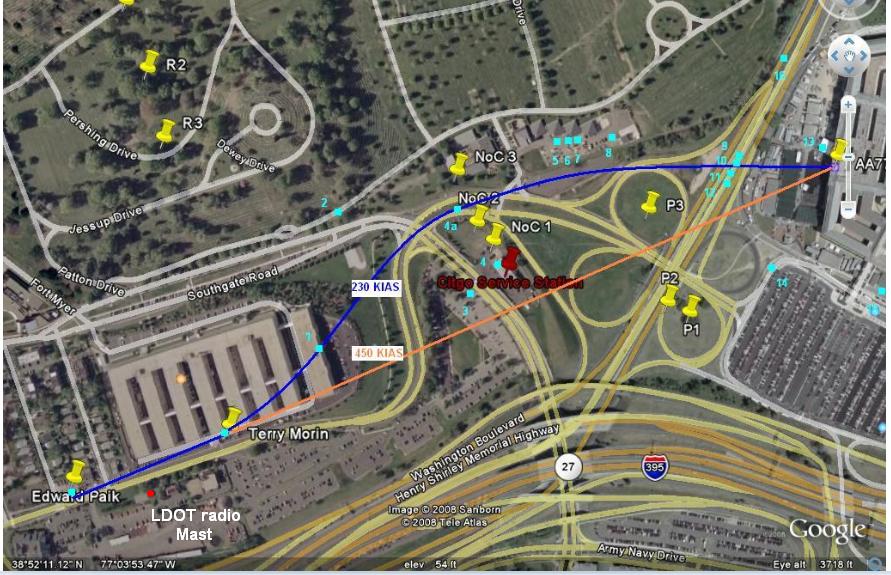
We KNOW however (see my aerial picture above with the blue squares picturing 18 NoC witnesses positions) that the plane was beginning to slightly curve to the left (North), from the lady in the room looking out her east-facade of the Sheraton hotel-window in front, and from Edward Paik sitting in front of his window looking out over the Pike, in his car repair shop which is 100 m past the Sheraton Hotel and 50 m ahead of the Navy Annex, along the Columbia Pike road, as also acknowledged by Terry Morin who said that the fuselage of the plane he saw was flying over the 4th and 5th Annex building, with only its right wing outside that building. Then Albert Hemphill (1) mentioned that the plane came over his left shoulder while he was standing near his office window overlooking the area in between the 8th Annex building and the Pentagon. You can online find out the exact position of Hemphill's office on 9/11. It's not in the south corner of the then 8th Annex Wing.
And William Middleton (2), who was working along Southgate Road on a cemetery path along that road, saw Flight 77 fly in front of him over the curve in Columbia Pike, just north of CITGO.
Which plane-position is strengthened by the reports of William Lagasse (4) and Chadwick Brooks (3), the two Pentagon Police men, one under the northern canopy and one on the parking on the other side of the road that runs along the west side of CITGO. They both say in their interview, that they bet their life on that NoC-position of the plane, when they saw it passing by.
They both are, after their CIT interview, placed under strict gag orders from the Pentagon, which fact really doesn't give the impression of an open, accountable society.
We also have Robert Turcios, a CITGO worker, who stood just outside the east side of the southern CITGO canopy, and said in his CIT interview, that he saw the right wing of the plane passing over the rim of the northern canopy and going over the tree just north of the eastern top of the northern canopy.
The 4 Cemetery workers (5, 6, 7 and 8) were also video interviewed in 2006 by CIT and all saw the plane first descending, coming down towards their positions, coming from over the center of the 8th Annex Wing, then turning away from them towards the Pentagon's west wall. One of them even details that the plane flew over the parking place along the south border of the Arlington National Cemetery border, when it slightly turned towards the Pentagon again.
Then the 4 car drivers (9=Christine Peterson, 10=Penny Elgas, 11=Vin Narayanan and 12=Don Mason) who stood in a traffic jam on Washington Boulevard, in front of the concrete helicopter landing pad. Who all 4 explained in all their main news reports that the plane flew straight over their heads.
Sean Boger (13), one of the two flight traffic operators in the Pentagon flight traffic tower just in front of the west wall, was also video interviewed by CIT in 2006, and said he definitely saw it flying low and in a slight bank towards him, to the right of the CITGO, on the north side of that gas station. And then it slammed just a few tens of meters on his left, on his south side, into the west wall of the Pentagon. At column 15, 3.3 meters high, with its nose cone smack right in the steel reinforced concrete second floor slab. Which was obliterated for just a few meters max. The plane was sliced open as a fish filet, the upper part continued to devastate the second floor area, the lower part did the same in the first floor area.
And the plane did not enter at the officially endorsed angle of around 50 degrees, but more like 80 to 85 degrees. And did not penetrate any further than the back of the later collapsed E-ring, the first ring in Wedge I, behind the outside wall.
Levi Stephens on the corner of South Parking (14) saw the plane coming over Washington Boulevard and going over the heli pad, then slamming in the west wall.
Roosevelt Roberts on the South Loading Dock (15) saw the plane flying low over the Annex, then turning while descending towards the Pentagon.
The photographer, Steve Riskus (16) who a few moments after impact took the first close up photos of the crash site, saw the plane flying perpendicular over Washington Boulevard, from his northern viewpoint, in front of the first huge overhead highway sign spanning only the south bound lanes just south of the two small trees in front of the heli pad. Thus coming from a clearly NoC path.
That's already 20 NoC witnesses.
Then we have Frank Probst walking on the footpath just about ten meters away from the first of the two trees beside Washington Boulevard and the south side of the heli pad, who had to dive to the ground to avoid being hit by the right jet engine of Flight 77.
And I found two other car drivers who said they stood very near to the helipad while the plane flew over their cars too. I mentioned them in this thread and other threads.
And one man looking out from his third floor window in the west wall and saw it coming straight over the Boulevard, not diagonal..
Another one in the South parking lot, who also saw the same behavior.
And I'm still searching all 9/11 Pentagon interviews to pinpoint keywords in all those reported interviews. Like heli pad, two trees, perpendicular, crossed, Boulevard, overhead, gas station, north, over my car, and so on.
Post by skyeagle409 at page 16, where he illogically concluded and
really thought that he effectively had proven my Opening Posts calculations wrong.
Well, just as a reminder to show where the official story followers all go wrong, like skyeagle409 again too :
He calculates with a ridiculous high speed of 400 KNOTS...! For a NoC trajectory, which is nowhere to be found in the official DFDR data, so, either the OS, based on that DFDR is right, or it is wrong and that DFDR is partly or totally falsified.
While I showed him already in my OP's that it should be about 230 KNOTS / 270 MPH, to fit all the known data described by the 25 NoC witnesses, and as used by me in the online turn and bank calculators.
Known data, like the turn radius, where my calculated turn radius and resulting curvature EXACTLY fits all 25 NoC flight path eyewitnesses their positional descriptions; where they themselves stood, and where the plane flew while they saw it pass them.
More known data, like the bank angles as reported by the bulk of the 25 NoC witnesses, only a few of them were never asked to describe that bank angle. Most of them showed with a model plane in hand, bank angles between 30 and 35 degrees, standard bank angles which are totally normal for passenger planes in a shallow turn.
Even more known data, like the turn curvature its starting point, just past the Sheraton Hotel, and the end point, the crash point at column 14 in the Pentagon West wall.
All these known NoC-flight data as all described by the witnesses, prescribe a very narrow group of air speeds, around that 230 KNOTS figure, when all small witness observation errors are taken in account and all these known data values are integrated in my online calculators. And correctly calculated by my OP's-posted online turn/bank angle calculators, to come up with an air speed within quite small speed value boundaries.
Resulting in speeds around 230 KNOTS, much slower than the officially endorsed last five seconds DFDR-air speeds of around 470 KNOTS. From the officially endorsed South of CITGO flight path.
That's a whopping 954 KMH SoC speed, near ground level, in dense air.
PS : I already showed skyeagle409 on page 17 which part of the data (the air speed) he took the wrong way, see my post on page 17.
PS 2 : These are the video interviews with the original 13 CIT eyewitnesses, who all saw a NoC flying plane, the 4 ANC workers interviews included, the guys who all 4 showed the 30 to 35 degrees bank angles with that model plane in hand :
www.youtube.com...
PS 3 : Its advisable to reread this mathematically IMPORTANT post of mine again, to see another mathematical proof, that what we see in the two shabby security-boot camera videos, is the perspective distortion of a NoC flying plane that was on a +/- 84 degree impact trajectory., and thus not on a 42 degree trajectory, as the SoC official theory endorses.....
Which proves that all the 5 light pole cuts, were STAGED.
The fact that not ONE mainstream news agency dares to pay intensive attention to a few of my hard evidence cases, like this one and like my WTC-7 seismic evidence, is showing the total supremacy of the global corporate-military complex over all truthful and honest news gathering and news spreading.
Those two mentioned cases are based by me on solely the information as offered by the government and its institutions, and then crosschecked by me, which shows clearly that their stories are false.
When we really had some honest, independent news companies left over, they would pull these two cases on their front pages, and rattle the chairs of Congress and the House.
Sadly enough, it will not happen in my lifetime anymore, I'm totally pessimistic about the coming decennium, strap yourself in, there's bad times ahead. Only the strong of heart and iron will owners, will survive.
Bill, aka Sceptic Overlord, owner of this website, seemingly out of some truly felt despair, you turned the evidence around, you wrote lately that since you saw no main network coverage of what the Truth movement has unearthed during the last decennium, it must have been not strong enough evidence, to be valuable enough, to be published outside "sinister" websites like ATS and a few others which have still existing 9/11 forums with participants that still keep digging up truly strong facts which prove the OS on basic points, wrong.
You make the logical error, to not see what really is going on, they are forbidden to pay attention.
You still have too much faith in the intrinsic honesty and steadfastness of the main networks, while you could know that they all have been paid and bought.
Or in a few stubborn cases, threatened to such end, that they don't dare to publish the truth anymore.
If some of the following posted Pentagon attack news-links in the coming years become broken, as I got used to so often in the last 15 years, use the
Internet Archive: the Wayback Machine :
archive.org...
Just copy and then paste the news link in their on-site link box, click enter and take your pick from one of the many possible retrieved dates, click first on the earliest date and see the link come to life again. Try then later dates for eventual updates for that article.
This is the very early, just one year after 9/11/2001 posted, original witness list from the day one, French internet poster "Barth".
It's his important and long, Pentagon Eyewitness List he gathered from multiple online news sources :
It means the plane came up along his left side (since he drove on the I-395 and thus not on Washington Boulevard) and he then saw it veering to the right. He thus describes the second half last part of the NoC curved flightpath. See my posted witness position aerial picture.
Note that the official DFDR shows no turning (veering) nor banking data in the last 10 seconds, just a straight flight path, with no horizontal left or right movements, only the fast "fluttering" up- and downwards results of the ground effect in the last 5 seconds (see my posted diagram, some posts ago).
The DFDR its last 10 seconds falsifier probably inserted his last 10 flight seconds of altered data, based on working autopilot corrections, while forgetting that all autopilot functions were switched off 10 minutes earlier, as can be seen in the probably still original preceding part of that DFDR.
I suppose only the last 10 seconds or so had to be altered, to mask the not planned NoC trajectory. Which left-right banking detour was probably caused by the neglected position of the VDOT radio mast, totally unexpected coming in sight of the remote controller, or the martyr pilot.
The DFDR alteration had to be done after those non-planned few seconds of NoC detour, since the physical enforcement for the SoC flight path had already taken place in the early morning darkness, namely the cutting of the 5 light poles.
The C-Ring exit hole, the cherry on the cake for the physical evidence for a SoC flight path, was cut out from the A-E drive with det cord or a Wall Breaching Unit, during the period just after 10:00 a.m., when all rescue workers were ordered out and to take shelter under the Route 27 overpass, because of a warning for a second plane on its way to the Pentagon (Flight 93).
Now a straight SoC flight path line could be proposed on internet forums, going through those 5 cut lamp poles, next the entrance hole at column 14 at the west wall's Wedge 1 and ending in the "exit" hole. Seemingly an abundance of physical evidence.
Read in the list another NoC witness report from Boger, Sean, Air Traffic Controller and Pentagon helipad tower chief.
archive.org...
Just copy and then paste the news link in their on-site link box, click enter and take your pick from one of the many possible retrieved dates, click first on the earliest date and see the link come to life again. Try then later dates for eventual updates for that article.
This is the very early, just one year after 9/11/2001 posted, original witness list from the day one, French internet poster "Barth".
It's his important and long, Pentagon Eyewitness List he gathered from multiple online news sources :
Bauer, Gary : "I was in a massive traffic jam, hadn't moved more than a hundred yards in twenty minutes. ... I had just passed the closest place the Pentagon is to the exit on 395 . . .-snip-
we realized the jet was coming up behind us on that major highway. And it veered to the right into the Pentagon.
-snip-
"...came from behind us and banked to the right and went into the Pentagon."Interview with Warren Smith.
www.massnews.com...
www.thecharlotteworld.com...
It means the plane came up along his left side (since he drove on the I-395 and thus not on Washington Boulevard) and he then saw it veering to the right. He thus describes the second half last part of the NoC curved flightpath. See my posted witness position aerial picture.
Note that the official DFDR shows no turning (veering) nor banking data in the last 10 seconds, just a straight flight path, with no horizontal left or right movements, only the fast "fluttering" up- and downwards results of the ground effect in the last 5 seconds (see my posted diagram, some posts ago).
The DFDR its last 10 seconds falsifier probably inserted his last 10 flight seconds of altered data, based on working autopilot corrections, while forgetting that all autopilot functions were switched off 10 minutes earlier, as can be seen in the probably still original preceding part of that DFDR.
I suppose only the last 10 seconds or so had to be altered, to mask the not planned NoC trajectory. Which left-right banking detour was probably caused by the neglected position of the VDOT radio mast, totally unexpected coming in sight of the remote controller, or the martyr pilot.
The DFDR alteration had to be done after those non-planned few seconds of NoC detour, since the physical enforcement for the SoC flight path had already taken place in the early morning darkness, namely the cutting of the 5 light poles.
The C-Ring exit hole, the cherry on the cake for the physical evidence for a SoC flight path, was cut out from the A-E drive with det cord or a Wall Breaching Unit, during the period just after 10:00 a.m., when all rescue workers were ordered out and to take shelter under the Route 27 overpass, because of a warning for a second plane on its way to the Pentagon (Flight 93).
Now a straight SoC flight path line could be proposed on internet forums, going through those 5 cut lamp poles, next the entrance hole at column 14 at the west wall's Wedge 1 and ending in the "exit" hole. Seemingly an abundance of physical evidence.
Read in the list another NoC witness report from Boger, Sean, Air Traffic Controller and Pentagon helipad tower chief.
Read also the report of Elgas, Penny. I commented extensively in other threads about her witness report (do an ATS search : LaBTop Elgas), and thus
post only her two most NoC indicating excerpts :
She stood thus a few cars behind the cars from Christine Peterson, Don Mason and Vin Narayanan, who explicitly told us that they stood in front of the Pentagon or even in front of the helipad (Christine Peterson) when the plane went right over their cars.
And she describes a slight last left bank which lifts the right wing (nearest to her car) upwards, and the left wing downwards, that's why she could see "the underside of the other wing as that other wing rocked slightly toward the ground".
Which makes it impossible for her to have witnessed a SoC flying plane, since the official SoC recovered DFDR does not show any left or right banking in the last 10 and more seconds of its data streams.
And a SoC flying plane can NEVER pass over a car halted in front of the Pentagon helipad.!
Look again at my aerial map, and realize that a SoC flying plane would come from BEHIND her, and not STRAIGHT at her as a NoC plane.
In case of a SoC plane, she would have stood traffic-jammed with her car just past the overpass bridge in Route 27, just behind a few cars in front of her, to be able to see the diagonal crossing of a SoC coming plane, as for an on my map drawn SoC flight path.
She would have needed to turn her head fully backwards, to even see a SoC flying plane coming from behind her.
But for the NoC plane's flight path I drew, she only needed to look sideways, to see the plane's nose coming STRAIGHT at her. And in the NoC flight path case, she described the part of the Pike that runs around the north part of the CITGO station. After that, the Pike indeed runs perpendicular on Route 27, where Penny indeed was on.
Note that Jeff Hill has about 10 phone interviews on his website (Search ATS : LaBTop Jeff Hill), with Pentagon attack witnesses.
Some of them, especially the Penny Elgas one, even more strengthens the NoC witness aspect for Penny.
I saw the plane coming in slow motion toward my car and then it banked in the slightest turn in front of me, toward the heliport. In the nano-second that the plane was directly over the cars in front of my car, the plane seemed to be not more than 80 feet off the ground and about 4-5 car lengths in front of me.was far enough in front of me that I saw the end of the wing closest to me and the underside of the other wing as that other wing rocked slightly toward the ground.
americanhistory.si.edu...
She stood thus a few cars behind the cars from Christine Peterson, Don Mason and Vin Narayanan, who explicitly told us that they stood in front of the Pentagon or even in front of the helipad (Christine Peterson) when the plane went right over their cars.
And she describes a slight last left bank which lifts the right wing (nearest to her car) upwards, and the left wing downwards, that's why she could see "the underside of the other wing as that other wing rocked slightly toward the ground".
Which makes it impossible for her to have witnessed a SoC flying plane, since the official SoC recovered DFDR does not show any left or right banking in the last 10 and more seconds of its data streams.
And a SoC flying plane can NEVER pass over a car halted in front of the Pentagon helipad.!
I was looking at the nose of an airplane coming straight at us from over the road (Columbia Pike) that runs perpendicular to the road I was on. The plane just appeared there- very low in the air, to the side of (and not much above) the CITGO gas station that I never knew was there.
Look again at my aerial map, and realize that a SoC flying plane would come from BEHIND her, and not STRAIGHT at her as a NoC plane.
In case of a SoC plane, she would have stood traffic-jammed with her car just past the overpass bridge in Route 27, just behind a few cars in front of her, to be able to see the diagonal crossing of a SoC coming plane, as for an on my map drawn SoC flight path.
She would have needed to turn her head fully backwards, to even see a SoC flying plane coming from behind her.
But for the NoC plane's flight path I drew, she only needed to look sideways, to see the plane's nose coming STRAIGHT at her. And in the NoC flight path case, she described the part of the Pike that runs around the north part of the CITGO station. After that, the Pike indeed runs perpendicular on Route 27, where Penny indeed was on.
Note that Jeff Hill has about 10 phone interviews on his website (Search ATS : LaBTop Jeff Hill), with Pentagon attack witnesses.
Some of them, especially the Penny Elgas one, even more strengthens the NoC witness aspect for Penny.
Col. Elliott, Bruce : Elliott, in a phone interview Wednesday, said he had just left the Pentagon and was about to board a shuttle van in a south parking lot when he saw the plane approach and slam into the west side of the structure. "I looked to my left and saw the plane coming in," said Elliott, who watched it for several seconds. "It was banking and garnering speed. I felt it was headed for the Pentagon." (...) "It was like a kamikaze pilot. I felt it was going to ram the Pentagon," he said. He said the craft clipped a utility pole guide wire, which may have slowed it down a bit before it crashed into the building and burst into flames
www.thehawkeye.com...
While he watched it for SEVERAL seconds, it was BANKING and garnering speed.
Exactly what the 4 ANC workers also explained to the CIT team of two.
Do now realize, that the officially endorsed, SoC flight path depicting DFDR, does not indicate ANY banking maneuver in those last 10 seconds, NONE.!
Do realize also, that one of the 4 ANC (Arlington National Cemetery) workers also said the same as Elliott, in his CIT video interview. That he saw the NoC plane clipping the top of a telephone/transformer pole on Columbia Pike, when it flew past him, over the long but narrow ANC south parking lot which lays beside the lane of the Pike, which runs from the Pentagon South parking lot, under the overpass in Route 27, including a sharp turn north of the CITGO
Hemphill, Albert : The aircraft was moving fast, at what I could only be estimate as between 250 to 300 knots. All in all, I probably only had the aircraft in my field of view for approximately 3 seconds. The aircraft was at a sharp downward angle of attack, on a direct course for the Pentagon. It was "clean", in as much as, there were no flaps applied and no apparent landing gear deployed. He was slightly left wing down as he appeared in my line of sight, as if he'd just "jinked" to avoid something. As he crossed Route 110 he appeared to level his wings, making a slight right wing slow adjustment as he impacted low on the West side of the building to the right of the heli tower and fire vehicle around corridor 5.
lists.travellercentral.com...
www.ournetfamily.com...
That estimated air speed is a much closer figure to my calculated NoC flying plane at 230 knots (270 MPH = 434 KMH), than the 473 KTS = 954 KMH from the recovered DFDR from Flight 77.
The plane was banking to the left, since it had to avoid a few hundred meters ago, the high steel beams of the LDOT radio tower. Route 110 is a misconception from the interviewer, that is Route 27, a.k.a. Washington Boulevard.
Thus, it first flew in a slight left bank, than it must have corrected that by a slight right bank, otherwise it could have never impacted at column 14 in the West wall. It would have missed the Pentagon, if it had not shifted to a slight right bank. The airspeed was low enough to be able to level off when crossing Route 27 (Route 110 in fact, runs at the back of the Pentagon, in between it and the Potomac river front there). Hemphill must mean a slow, slight right wing UP correction just before impact, since we have photos from a slightly tilted upwards imprint of the right wing on the west wall facade.
Btw, he saw the plane coming from over his right shoulder, not his left one as I wrote in my former post. His office was thus at the left wing side of the plane.
Lagasse, William : Sgt. William Lagasse, a Pentagon police dog handler, the son of an aviation instructor, was filling up his patrol car at a gas station near the Pentagon when he noticed a jet fly in low. He watched as the plane plowed into the Pentagon. Initially, he thought the plane was about to drop on top of him -- it was that close. -snip-
I saw the aircraft above my head about 80 feet above the ground, 400 miles an hour. The reason, I have some experience as a pilot and I looked at the plane. Didn't see any landing gear. Didn't see any flaps down. I realized it wasn't going to land. . . . It was close enough that I could see the windows and the blinds had been pulled down. I read American Airlines on it. . . .I got on the radio and broadcast. I said a plane is, is heading toward the heliport side of the building.
206.181.245.163...
Lexis-Nexis-link
www2.hawaii.edu...
Realize that we have Sgt. Lagasse standing at the northern gas pumps, under the northern CITGO canopy, filling up his Police cruiser's tank, while looking north.
He stands with his back to the south side of the gas station, so he could not see the official south of CITGO (SoC) flying plane, even if he had wanted to.
Leibner, Lincoln : Maj. Leibner drove in and made it as far as the south parking lot, where he got out on foot. "I heard the plane first," he said. "I thought it was a flyover Arlington cemetery." From his vantage point, Maj. Leibner looked up and saw the plane come in. "I was about 100 yards away," he said. "You could see through the windows of the aircraft. I saw it hit." The plane came in hard and level and was flown full throttle into the building, dead center mass, Maj. Leibner said. "The plane completely entered the building," he said.
www.smh.com.au...
www.theosuobserver.com...
www.usmedicine.com...
abc.net.au...
Seen from the south parking lot's northwestern point, my proposed NoC flight path looks far more as an Arlington Cemetery flyover than the straight line of the SoC official flight path.
Marra, David : David Marra, 23, an information-technology specialist, had turned his BMW off an I-395 exit to the highway just west of the Pentagon when he saw an American Airlines jet swooping in, its wings wobbly, looking like it was going to slam right into the Pentagon: "It was 50 ft. off the deck when he came in. It sounded like the pilot had the throttle completely floored.
The plane rolled left and then rolled right. Then he caught an edge of his wing on the ground." There is a helicopter pad right in front of the side of the Pentagon. The wing touched there, then the plane cartwheeled into the building.
www.time.com...
Marra clearly describes the left bank followed by the right bank, as in my above NoC flight path for Flight 77. The use of the term "rolled" means a relatively slow process. The words "tilted" or "wobbled" would have indicated a much faster process.
Mitchell, Terry : This is a hole in -- there was a punch-out. They suspect that this was where a part of the aircraft came through this hole, although I didn't see any evidence of the aircraft down there. (...) This pile here is all Pentagon metal. None of that is aircraft whatsoever. As you can see, they've punched a hole in here. This was punched by the rescue workers to clean it out. You can see this is the -- some of the unrenovated areas where the windows have blown out.
www.patriotresource.com...
One of the first on the scene with a camera, he was the chief Audiovisual Division, Office of ASD PA at the Pentagon.
And he didn't see any aircraft metal there.! At the so called "exit punch-out" hole in the brick wall of the outer C-ring wall. That was a punch-in hole.! He exactly called it so.!
The hole is far too big to be caused by still fast moving aircraft plus internal debris, a lot of it would have been ended up on the other B-wall. When something smashes such a huge hole in a double-stone brick wall, it will burst out, together with all those bricks. And just about 30 to 50 bricks maximum can be seen laying in the water in later shot photos. Just two meters outside the C-ring wall periphery.
And by the way, the whole outer rim of that C-ring hole shouts : Military Wall Breach Unit, or Mil-spec Detonation Cord. The bricks breakage pattern is exactly the same as when f.ex. a det-cord would have been glued to the outside (driveway side) of that C-ring outer wall and then had been detonated.
Another indication of the use of explosives to create an entrance hole in the outer C-Ring brick wall is this report :
Americanmemorials (end of list) : Other witnesses said the plane crash was followed by an explosion about 15 minutes later that could be heard miles away - apparently the sound of a large portion of the Pentagon collapsing.
www.americanmemorials.com...
That must have been the time around 10 o'clock, when all rescuers were ordered out and towards the overpass in Route 27. A perfect moment to create that later called "exit hole" in that C-Ring outer brick wall, from inside the A-E Drive that ran as a broad enough for cars, delivery path between Ring B and Ring C.
The roof of the damaged E-ring section of Wedge 1 gave way and crashed down at 10:10 a.m.
Morin, Terry. Study again this below aerial picture of the Navy Annex and the Pentagon and the CITGO gas station, and look at my drawn-in North and
South of CITGO flight paths, to see what Terry Morin in his first ever interview, in September 2001, was reporting from fresh memory, what he saw, and
WHERE he indeed saw all of it :
From September 2001 up to 2006 when the two from CIT came with their official story contradicting video interviews, and also their telephone one with Terry Morin, we only had this short text from the Barth List, which gave food to a lot of misunderstandings :
Where I placed that [X], a lot of Terry's original text was neglected by Barth.
The outer portion of the FOB is that 2/5th southern part of all 8 Wings of the Navy Annex FOB, to the south of all those small passage blocks between all 8 Wings, positioned at 2/5th of all 8 Wings. See my aerial picture above.
I positioned Terry, back in 2008, correctly near that outer southern Annex wall. About 6 steps out, on the parking lot there. Since I had not only read this too short Barth List text, but also read the full text of Terry himself, which placed him there.
The above text however, gave the impression that he stood just a few meters outside the Wing 5 building, near that small but high passages block that connected Wing 4 and 5, and thus seemed standing still in between those two high Wings building walls, only a few steps away from that passage block. Turns out not to be the case, he was 6 steps out, on the parking lot already, when he heard the plane coming towards him, over the outer southern portion of the first 4 Annex Wings.
And his below following description : "northern row of high trees", is a dead give away of the plane's exact position, which could not have been on the officially endorsed South of CITGO flight path, since he precisely described it as going over the row of northern trees, which were exactly under his view of the last part of the plane's North of CITGO flight path.
Study my above aerial picture again to see what I mean, for yourself. The plane was still quite high when Terry followed its first, left banking part of its curved around the CITGO, flight path.
But it was in a steep downwards trajectory, all the way to its crossing over Route 27.
Which means that Terry needed another 1 to 2 seconds to reach a viewing spot at the fence of that narrow southern side Annex parking, to have been able to see the body of the plane disappear behind/under the northern row of high trees, that stood along the back of the narrow Joyce street western parking, across the street opposite of the westerly situated entrance-side of the CITGO, exactly where Sgt. Chadwick Brooks stood, beside his Pentagon Police cruiser. And which appearance of that plane and at which exact spot, Chadwick described to the last letter exact.
See his and Lagasse's 2006 CIT video interview I posted in this thread.
From September 2001 up to 2006 when the two from CIT came with their official story contradicting video interviews, and also their telephone one with Terry Morin, we only had this short text from the Barth List, which gave food to a lot of misunderstandings :
Barth List, the far too short excerpt from Terry Morin's real words : Having just reached the elevator in the 5th Wing of BMDO Federal Office Building (FOB) #2. [X] He heard "an increasingly loud rumbling. One to two seconds later the airliner came into my field of view". By that time the noise was absolutely deafening. The aircraft was essentially right over the top of me and the outer portion of the FOB (flight path parallel the outer edge of the FOB).
Where I placed that [X], a lot of Terry's original text was neglected by Barth.
The outer portion of the FOB is that 2/5th southern part of all 8 Wings of the Navy Annex FOB, to the south of all those small passage blocks between all 8 Wings, positioned at 2/5th of all 8 Wings. See my aerial picture above.
I positioned Terry, back in 2008, correctly near that outer southern Annex wall. About 6 steps out, on the parking lot there. Since I had not only read this too short Barth List text, but also read the full text of Terry himself, which placed him there.
The above text however, gave the impression that he stood just a few meters outside the Wing 5 building, near that small but high passages block that connected Wing 4 and 5, and thus seemed standing still in between those two high Wings building walls, only a few steps away from that passage block. Turns out not to be the case, he was 6 steps out, on the parking lot already, when he heard the plane coming towards him, over the outer southern portion of the first 4 Annex Wings.
And his below following description : "northern row of high trees", is a dead give away of the plane's exact position, which could not have been on the officially endorsed South of CITGO flight path, since he precisely described it as going over the row of northern trees, which were exactly under his view of the last part of the plane's North of CITGO flight path.
Study my above aerial picture again to see what I mean, for yourself. The plane was still quite high when Terry followed its first, left banking part of its curved around the CITGO, flight path.
But it was in a steep downwards trajectory, all the way to its crossing over Route 27.
Which means that Terry needed another 1 to 2 seconds to reach a viewing spot at the fence of that narrow southern side Annex parking, to have been able to see the body of the plane disappear behind/under the northern row of high trees, that stood along the back of the narrow Joyce street western parking, across the street opposite of the westerly situated entrance-side of the CITGO, exactly where Sgt. Chadwick Brooks stood, beside his Pentagon Police cruiser. And which appearance of that plane and at which exact spot, Chadwick described to the last letter exact.
See his and Lagasse's 2006 CIT video interview I posted in this thread.
Terry Morin : As the aircraft flew ever lower I started to lose sight of the actual airframe as a row of trees to the Northeast of the FOB, blocked my view.
I could now only see the tail of the aircraft.
I believe I saw the tail dip slightly to the right indicating a minor turn in that direction. The tail was barely visible when I saw the flash and subsequent fireball rise approximately 200 feet above the Pentagon.
www.coping.org...
Use the WayBack machine website, paste the above link into it, to read the original text as saved by Archive.org on November 22, 2001.
I'll make it easy for the readers, here's the full Archive.org link to that 11/22/2001 publication at Coping.org by Terry himself :
Xweb.archive.org...(copy and paste this part first in your web browser's address line and remove the X )
Xwww.coping.org... (then copy and paste this part right behind the first part's last "/", and then remove also that X and then use Enter on your keyboard).
Choose the date of the earliest saved text, and press Enter again.
Then you read the real, FULL text by Terry.!
Which gives a totally different position for Terry, than the short cut-out Barth-excerpts insinuate.
The text below hold in bolded italic the only position-insinuating parts that Barth took out from Terry's own publication, and pasted them together, so it looked to the casual reader as if Terry was only 2 seconds out from his elevator position inside the Wing 5 building, which is NOT true at all, Terry was already ten steps out from between Wings 4 and 5 :
Terry Morin : I had just reached the elevator in the 5th Wing of BMDO/Federal Office Building (FOB) #2 – call it approximately 9:36 AM. I was already trying to make some sense out of the World Trade Tower attacks having heard about them on the radio. The news was sketchy, but the fact that it was a terrorist attack was already known. I then realized that I was wearing sunglasses and needed to go back to Lot 3 to retrieve my clear lenses. Since it was by no means a short walk to my car, I was upset with myself for being so distracted.
Approximately 10 steps out from between Wings 4 and 5, I was making a gentle right turn towards the security check-in building just above Wing 4 when I became aware of something unusual. I can’t remember exactly what I was thinking about at that moment, but I started to hear an increasingly loud rumbling behind me and to my left. As I turned to my left, I immediately realized the noise was bouncing off the 4-story structure that was Wing 5. One to two seconds later the airliner came into my field of view. By that time the noise was absolutely deafening. I instantly had a very bad feeling about this but things were happening very quickly. The aircraft was essentially right over the top of me and the outer portion of the FOB (flight path parallel the outer edge of the FOB).
I saw the tail dip slightly to the right indicating a minor turn in that direction.
He describes exactly the last part of the two-part banking maneuver, that last, slightly right-turning, right banking maneuver by the NoC flying plane, after it had passed north of the CITGO gas station, which last part made it possible to let the plane crash at column 14 of the Pentagon west wall. As can be seen in my aerial NoC drawing above.
Terry Morin's description also indicates more than a few seconds duration for the whole left and right banking maneuver towards CITGO and then back to
the Pentagon's west wall, after it came over his head at the 6th Annex Wing building :
Look at the aerial map I posted above, and imagine Terry standing at the parking along Columbia Pike, outside the Annex south side walls, a few seconds after the plane flew over him and the Annex.
In his own descriptive words, he was clearly describing a NoC flight path, because his words are logical for a NoC case, since the row of high trees NORTH-east of the Annex-FOB is EXACTLY under the LAST, now RIGHT banking turn part from my proposed NoC flight path, when seen from his higher up position beside that Annex parking fence on the Annex hill top. His explicit use of the word "northeast" indicates very strongly a northerly flight path for Flight 77, around the northern canopy of the CITGO gas station which is situated beside the eastern side of Joyce Street.
And realize that the plane was descending rapidly after it passed over the right shoulder of Albert Hemphill standing in his northerly office in the 8th Annex Wing building, and after it passed over the thick foliage of that northeastern row of high trees along the west side of Joyce Street, causing most of the lower parts of the plane to become nearly invisible to Terry Morin, only the tail was still vaguely seen by him. The main fuselage and its wings he couldn't see anymore during that last slight right bank part of the NoC trajectory, back towards the Pentagon's first floor slab in the west wall. As interpreted by him as a right bank, since he saw that tail dip slightly to the right.
Since there is also a physical imprint on the concrete of the west wall's first floor area, from a slightly upwards tilted right wing front area, which means a slightly left banking attitude of the plane at the moment of impact, we can conclude that the plane in the last 150 meters/yards came out of the right bank and corrected that by a slight last left banking maneuver, to try to level off again.
Note that the recovered DFDR does not show ANY sign of any banking maneuvers in the last ten seconds of its data streams.
And too many NoC witnesses all indicated left and right banking maneuvers and "wobbling" in those last ten seconds of AA-77 its flight path.
But not the DFDR.! Its digital data show us a straight, leveled off line of flight in those last ten seconds. No banking at all.
If Terry however had described a plane flying on a SoC flight path, he would have described the plane's actual airframe as being blocked from his view by either the CENTER of the row of trees to the EAST of the FOB, or as being blocked from his view by the SOUTH-east part of that same long row of high trees.! He would have used the words center, east or southeast, instead of his actual NORTHEAST positional description for that row of trees where the airframe disappeared behind, leaving only the tall tail visible to him.
However, he used explicitly these very specific words :
""a row of trees to the Northeast of the FOB, blocked my view"".
The northeastern part of that long row of trees you can easily find on my above posted aerial map, since it's the northern row of trees that is situated to the left of the, in bold red colored text, typed word "Citgo" from the red map-pin text "Citgo Service Station".
Terry Morin : Elapsed time from hearing the initial noise to when I saw the impact flash was between 12 and 15 seconds.
Look at the aerial map I posted above, and imagine Terry standing at the parking along Columbia Pike, outside the Annex south side walls, a few seconds after the plane flew over him and the Annex.
In his own descriptive words, he was clearly describing a NoC flight path, because his words are logical for a NoC case, since the row of high trees NORTH-east of the Annex-FOB is EXACTLY under the LAST, now RIGHT banking turn part from my proposed NoC flight path, when seen from his higher up position beside that Annex parking fence on the Annex hill top. His explicit use of the word "northeast" indicates very strongly a northerly flight path for Flight 77, around the northern canopy of the CITGO gas station which is situated beside the eastern side of Joyce Street.
And realize that the plane was descending rapidly after it passed over the right shoulder of Albert Hemphill standing in his northerly office in the 8th Annex Wing building, and after it passed over the thick foliage of that northeastern row of high trees along the west side of Joyce Street, causing most of the lower parts of the plane to become nearly invisible to Terry Morin, only the tail was still vaguely seen by him. The main fuselage and its wings he couldn't see anymore during that last slight right bank part of the NoC trajectory, back towards the Pentagon's first floor slab in the west wall. As interpreted by him as a right bank, since he saw that tail dip slightly to the right.
Since there is also a physical imprint on the concrete of the west wall's first floor area, from a slightly upwards tilted right wing front area, which means a slightly left banking attitude of the plane at the moment of impact, we can conclude that the plane in the last 150 meters/yards came out of the right bank and corrected that by a slight last left banking maneuver, to try to level off again.
Note that the recovered DFDR does not show ANY sign of any banking maneuvers in the last ten seconds of its data streams.
And too many NoC witnesses all indicated left and right banking maneuvers and "wobbling" in those last ten seconds of AA-77 its flight path.
But not the DFDR.! Its digital data show us a straight, leveled off line of flight in those last ten seconds. No banking at all.
If Terry however had described a plane flying on a SoC flight path, he would have described the plane's actual airframe as being blocked from his view by either the CENTER of the row of trees to the EAST of the FOB, or as being blocked from his view by the SOUTH-east part of that same long row of high trees.! He would have used the words center, east or southeast, instead of his actual NORTHEAST positional description for that row of trees where the airframe disappeared behind, leaving only the tall tail visible to him.
However, he used explicitly these very specific words :
""a row of trees to the Northeast of the FOB, blocked my view"".
The northeastern part of that long row of trees you can easily find on my above posted aerial map, since it's the northern row of trees that is situated to the left of the, in bold red colored text, typed word "Citgo" from the red map-pin text "Citgo Service Station".
Narayanan, Vin : At 9:35 a.m., I pulled alongside the Pentagon. With traffic at a standstill, my eyes wandered around the road, looking for the cause of the traffic jam. Then I looked up to my left and saw an American Airlines jet flying right at me. The jet roared over my head, clearing my car by about 25 feet. The tail of the plane clipped the overhanging exit sign above me as it headed straight at the Pentagon. The windows were dark on American Airlines Flight 77 as it streaked toward its target, only 50 yards away.
www.usatoday.com...
Vin, or the reporter, gave a good description of the position of Vin's car, somewhere alongside the west wall of the Pentagon, and it must have been in the HOV-lane going north, since Vin's USA Today offices were situated in Rosslyn, which lays just a few miles north of the Pentagon.
And as we can see in the earliest video of the Pentagon area I posted already in this thread, it were only the center HOV lanes of Route 27, that were jammed, not the far right northern going and Pentagon North-parking exit lane, nor the far left south going lanes, there we see still cars moving, in that first, aerial helicopter view, news video.
Since he looked "up to my left" to be able to see the plane as coming to him from over my blue NoC curved flight path line on my above posted aerial map,"flying right at me", he must have been at my witness positions 11 or 12 on my above aerial map (Mason or Narayanan), not 9 or 10, since that were Elgas and Peterson (she was 9, the furthest north), he could have never described a SoC flying plane (my orange straight line on my aerial map), since such a flight path MUST have been described by him as coming from BEHIND him. And surely not as "flying right at me". Study my aerial map again. If reporting a SoC plane, Vin had to turn his head nearly 180 degrees backwards, while for a NoC plane only 90 degrees sideways.
He said the impact target was only 25 yards away, it was in fact 110 yards away from under his NoC flight path position for his car. If his car would have been near the overpass bridge, the impact would have been 400 yards away.
25 Feet high is 8.2 meters high. A Route 27 lamp pole was 9 meters high. No lamp pole's top was clipped near the helipad.
The "clipped overhanging exit sign" was standing just beside the Route 27 its security rails, a few meters south of the two trees in front of the concrete of the helicopter landing pad. It was a small yellow sign and hung on a curved post. But it did not look to me as 25 feet/8 meters high. More like 5 meter high.
The plane must have passed him just in front of him, not over him, since he could see dark windows, which one can't see when a jet plane "roared over my head". Probably its right wing roared over him. And Christine Peterson was very distinct, she assured us the plane went right over her car (the blue square nr 9).
This eyewitness at my position number 9, Christine, is the strongest additional one on top of the 13 witnesses already video and telephone interviewed
by the two from CIT in 2006. And together with the positional description from Penny Elgas, we can easily place Penny at the number 10, 11 or 12
position on Route 27 a.k.a. Washington Boulevard, in my above aerial map picture.
Some 4 or 5 cars behind Christine, as Penny explained herself, by saying she stood a few cars behind the ones the plane flew straight over, while she saw the right wing tip fly past her, just in front of her car.
Look at my aerial map, the small blue square number 9 depicts Christine's car, about 10 meters ahead of the first of the two trees beside Route 27, and right in front of the white concrete square of the helipad. Right under the NoC flying plane.
Even if she would have been under the flight path of a SoC flying plane, she would have needed to turn her head 180 degrees to see the plane approaching, and would have reported it as coming from behind her, not from her left.
I also posted a few times already a photo by Steve Riskus, where you can see Christine (the tall, young African-american woman), standing beside her car, but on top of the concrete divider between the HOV and normal north going lanes, right in front of the helipad and just beside the most southern one of the two trees on the rim of the Pentagon lawn.
And you see in another Riskus photo, Penny standing outside her car, exactly where she said she stood in that traffic jam on 9/11 (A few cars behind Christine's, where the plane flew over). She's a short robust white woman, I posted a photo of her while she was handing over the small wing front part, she found under the side rail beside her car, to the curator of the 9/11 Smithsonian Institute's museum.
And I also posted a photo of Christine, while she gets her University diploma handed over by the Dean of her University.
www.naualumni.com...
Isn't it very indicative of the selective reading from all the official SoC flight path defenders, that they never ever tried to counter Christine and Penny's words, and their positional photographs , as such convincing, very strong evidence for the NoC flight path from above?
How is it possible at all, in a seemingly "open" society as the US one, that this kind of official story-shattering evidence is not attracting the certainly deserving attention by the main networks.???
I didn't make it up, it's all in the public domain, from day one on.!
Some 4 or 5 cars behind Christine, as Penny explained herself, by saying she stood a few cars behind the ones the plane flew straight over, while she saw the right wing tip fly past her, just in front of her car.
Peterson, Christine : October 18, 2001. I was at a complete stop on the road in front of the helipad at the Pentagon; what I had thought would be a shortcut was as slow as the other routes I had taken that morning. I looked idly out my window to the left -- and saw a plane flying so low I said, "holy cow, that plane is going to hit my car" (not my actual words). The car shook as the plane flew over. It was so close that I could read the numbers under the wing. And then the plane crashed.
Look at my aerial map, the small blue square number 9 depicts Christine's car, about 10 meters ahead of the first of the two trees beside Route 27, and right in front of the white concrete square of the helipad. Right under the NoC flying plane.
Even if she would have been under the flight path of a SoC flying plane, she would have needed to turn her head 180 degrees to see the plane approaching, and would have reported it as coming from behind her, not from her left.
I also posted a few times already a photo by Steve Riskus, where you can see Christine (the tall, young African-american woman), standing beside her car, but on top of the concrete divider between the HOV and normal north going lanes, right in front of the helipad and just beside the most southern one of the two trees on the rim of the Pentagon lawn.
And you see in another Riskus photo, Penny standing outside her car, exactly where she said she stood in that traffic jam on 9/11 (A few cars behind Christine's, where the plane flew over). She's a short robust white woman, I posted a photo of her while she was handing over the small wing front part, she found under the side rail beside her car, to the curator of the 9/11 Smithsonian Institute's museum.
And I also posted a photo of Christine, while she gets her University diploma handed over by the Dean of her University.
www.naualumni.com...
Isn't it very indicative of the selective reading from all the official SoC flight path defenders, that they never ever tried to counter Christine and Penny's words, and their positional photographs , as such convincing, very strong evidence for the NoC flight path from above?
How is it possible at all, in a seemingly "open" society as the US one, that this kind of official story-shattering evidence is not attracting the certainly deserving attention by the main networks.???
I didn't make it up, it's all in the public domain, from day one on.!
Probst, Frank : "I was standing on the sidewalk (parallel to the site of impact)...and I saw this plane coming right at me at what seemed like 300 miles an hour.
I dove towards the ground and watched this great big engine from this beautiful airplane just vaporize," said Frank Probst, a member of the Pentagon renovations crew.
www.dcmilitary.com...
So Frank stood somewhere between the car-witness positions 12 and 9 on my aerial map, since that is the only parallel part of that footpath, to the Pentagon west wall, the site of impact.
And there he saw the NoC plane "coming right at me ".
Not from BEHIND him, as he should have had to explain, if he would have stood UNDER a SoC flight path on that same sidewalk, but then on its southern part (see the aerial map), going to the South Parking lot.
The air speed is also spot-on, very near the by me in the online turn/bank calculator calculated 230 knots for a NoC turning and banking plane.
Impossible for him to describe a SoC flying plane, despite the clearly inserted last words by a news reporter in the other Barth-link about him.
About 9:25 a.m., he stopped by the renovation workers' trailer just south of the Pentagon heliport. -snip- The thought stuck with Probst as he picked up his notebook and walked to the North Parking Lot to attend his meeting. Probst took a sidewalk alongside Route 27, which runs near the Pentagon's western face.
There was a small gate-door in the fence around the trailers area, just beside that renovation workers' trailer. On aerial photos of the lawn from just a few days before 9/11, you can clearly see a worn out path made by human feet, through the grass of the lawn, leading from that gate-door, straight to the parallel part of the footpath along Route 27 which was running beside my witness positions 12 to 9 on my aerial map. And just a few meters short of those two trees there in front of the helipad, growing in between the footpath and the guide rails of Route 27.
Washington Post, the very last link from the above excerpts from the Barth List at :
www.911review.com...
READ it, and realize where we are heading into.
EDIT : Read the latest Supreme Court decision :
US Supreme Court Declines to Hear Petition on Internet Kill Switch.
www.911review.com...
READ it, and realize where we are heading into.
EDIT : Read the latest Supreme Court decision :
US Supreme Court Declines to Hear Petition on Internet Kill Switch.
edit on 1/2/16 by LaBTop because: (no reason given)
The last 21 posts were by labtop.
I'm sorry but that's just too much for me to read.
Two or three paragraphs is about all I can digest at one time.
I'm sorry but that's just too much for me to read.
Two or three paragraphs is about all I can digest at one time.
Penny Elgas drove a little Dodge Neon, search for her near that car in the Steve Riskus Pentagon attack photos. She's a small compact lady with short
cut hair, as seen when she presents the airplane wing-front fragment, she found just outside her car, to National Museum of American History curator
William Yeingst.
americanhistory.si.edu...
americanhistory.si.edu...
John Farmer's 9/11 Documents and Resources page.
John is still a member here, not active the last few years, under the ATS screen name 911files.
bluecollarrepublican.wordpress.com...
This REALLY HUGE repository from Erik Larson, who was very active at ATS in the first 8 years after 9/11 (under the screen name ??????? ), is Erik's 9/11 Document Archive, saving a huge 9/11 Commission collection of pages, and a lot of DFDR based pages from the recovered ones from Flight 77 at the Pentagon and Flight 93 at Shanksville.
www.scribd.com...
The problem with the AA-77 DFDR is obvious, this thread is all about the last 10 seconds of it, which seems to be falsified, after reviewing all those witness accounts I just posted.
It is the simplest form of influencing the global audience. You need just one man to falsify those last 10 seconds, and those two days that the AA-77 DFDR was "lost" from the official FBI hands is by far enough to easily alter those last 10 seconds of DFDR-data.
After that, thousands of would-be aeronautical hobbyist and seemingly professionals are busy analyzing the whole bulk of flight data, while not paying enough attention to the real culprit, those last 10 seconds of flight as observed by credible eyewitnesses, which indicate really clearly, a totally different NoC flight path, instead of the SoC flight path concluded from the DFDR, and the additional physical "evidence" concluded from the 5 cut lamp poles and the "exit" hole in the outer C-Ring brick wall.
That way, the seemingly overload of officially endorsed "evidence" is created by good willing participants in the enrolling online and offline discussions, many books are written, all based on one seemingly tiny discrepancy. They all unknowingly aided the 9/11 Planners, who were that way for free assisted by all those well intended, but very mislead participants in the ongoing discussions.
This is a page-link from the PumpItOut forum in one of my 2012 posts, filled with audio interviews by telephone (now audible again), made by Jeffrey
Hill, the owner of that forum, with 22 Pentagon-eyewitness telephone interviews with Jeff, about the Pentagon attack :
Thread title : NoC versus SoC issue. Let's set the facts straight, once and for all.
www.abovetopsecret.com...
Especially the spoken words from Penny Elgas, Vin Narayanan and Albert Hemphill should be compared with the written words from the Barth List in my above recent posts.
This is the phonecall from CIT with Hemphill, made just before Jeff Hill phoned him.
Jeff Hill phoned him later again to tell Hemphill that CIT and himself had recorded those calls, here is that last later call, Albert was very upset about that :
www.pumpitout.com...
Hemphill's line of sight from his office in the Annex Wing 8, in 2001:

Realize, that my NoC proposed flight path ALSO enters in his view, from over his RIGHT shoulder.
More recently joined ATS members or readers should read at least that whole page 10 of my NoC versus SoC thread, and I hope the whole thread, to get a good grip on the intensity with which good willing US citizens are defending a very simple lie ( those last 10 seconds of the AA-77 flight path).
It's obvious after reading that thread, that some deeply patriotic, well meaning Americans can't understand that it's not the WHOLE American government, that is guilty of misleading its citizens and the rest of the world.
On the contrary, it's a 9/11-complot of a compact group of influential and powerful participants in government and the military/industrial circles that planned this attack, to keep the multiple wars-based US economy going, to get massive votes for much more military spending again and to switch the focus from only a few local wars that the US was the last 55 years busy with, to wide spread global wars against terrorists.
Which planned wars on terrorism are from a military economy its spending viewpoint, far better in the long term, than inventing local wars every few years, to uphold this 70 years old US war economy.
The fast modernization of US warfare is based on 9/11, the personnel step-down to compactness of invading units, the rise of the weaponized drones equipped with anti personnel rockets and missiles, in totality it breaks down to a swift move to making wars possible, working from behind a keyboard and a screen.
Send in the drones against far less equipped adversaries, and the outcome is clear.
Starting a war against the rising new super powers is a whole other part of that tactical book.
Thread title : NoC versus SoC issue. Let's set the facts straight, once and for all.
www.abovetopsecret.com...
Especially the spoken words from Penny Elgas, Vin Narayanan and Albert Hemphill should be compared with the written words from the Barth List in my above recent posts.
This is the phonecall from CIT with Hemphill, made just before Jeff Hill phoned him.
Jeff Hill phoned him later again to tell Hemphill that CIT and himself had recorded those calls, here is that last later call, Albert was very upset about that :
www.pumpitout.com...
Hemphill's line of sight from his office in the Annex Wing 8, in 2001:
Realize, that my NoC proposed flight path ALSO enters in his view, from over his RIGHT shoulder.
Hemphill : The aircraft was moving fast, at what I could only estimate as between 250 to 300 knots, All in all, I probably only had the aircraft in my field of view for approximately 3 seconds.
More recently joined ATS members or readers should read at least that whole page 10 of my NoC versus SoC thread, and I hope the whole thread, to get a good grip on the intensity with which good willing US citizens are defending a very simple lie ( those last 10 seconds of the AA-77 flight path).
It's obvious after reading that thread, that some deeply patriotic, well meaning Americans can't understand that it's not the WHOLE American government, that is guilty of misleading its citizens and the rest of the world.
On the contrary, it's a 9/11-complot of a compact group of influential and powerful participants in government and the military/industrial circles that planned this attack, to keep the multiple wars-based US economy going, to get massive votes for much more military spending again and to switch the focus from only a few local wars that the US was the last 55 years busy with, to wide spread global wars against terrorists.
Which planned wars on terrorism are from a military economy its spending viewpoint, far better in the long term, than inventing local wars every few years, to uphold this 70 years old US war economy.
The fast modernization of US warfare is based on 9/11, the personnel step-down to compactness of invading units, the rise of the weaponized drones equipped with anti personnel rockets and missiles, in totality it breaks down to a swift move to making wars possible, working from behind a keyboard and a screen.
Send in the drones against far less equipped adversaries, and the outcome is clear.
Starting a war against the rising new super powers is a whole other part of that tactical book.
NoC path : The 234.109 KTS ( 269.4 MPH = 434 KMH) airspeed as witnessed by the NoC bystanders would have taken the plane around 7 seconds to
travel the 825 meters long slightly curved trajectory from the Annex 8th Wing roof to the impact point at column 14 in the west wall of the
Pentagon :
434000 meters/hr = 434000 m / 3600 secs = 120.55 meter ( ~ yards) per second.
SoC path : The 900 to 954 KMH (530 to 545 MPH = 473 knots) air speeds in the last 5 seconds of AA-77 its recovered DFDR would have taken AA-77 about 3 seconds to travel the straight as a ruler 780 meters of trajectory from the Annex its 8th Wing roof top to column 14 in the Pentagon's west wall.
954000 meters/hr = 954000 m / 3600 secs = 265 meter ( ~ yards) per second.
Sean Boger, an experienced air traffic controller in the Pentagon heliport Tower, guessed 10 to 12 seconds, to be the time it took the NoC plane to come from over the Annex 8th Wing to its impact point, some 40 meters to the left of him.
He was looking towards the CITGO gas station from inside his first floor's control room in that Pentagon air traffic control tower, standing with his back to the west wall.
He described the last half of the full flight path he saw, when he says he definitely saw it approaching in a slight right wing down attitude ( which is a slight right bank) from over the area NORTH of the CITGO gas station.
Albert Hemphill says he guessed it took the plane he saw about 3 seconds to cover the distance from when he saw it come into his view (passed the Navy Annex its 8th Wing roof? ) to impact.
But he also said :
""Terry : The aircraft was moving fast, at what I could only estimate as between 250 to 300 knots.""
Which points to my NoC curved trajectory airspeed (so not at all to the more than double as fast SoC, DFDR extracted air speed), and thus a time to cover his witnessed trajectory of about 7 seconds. So his descriptions are not conclusive. Together with the ones from Boger and Morin, one feels his speed description is perhaps better guessed than his elapsed time guess.
Terry Morin said he thought it took the plane about 12 to 15 seconds to cover the distance from when he first heard its engines noise up till impact.
And 1 to two seconds after he first heard it, it came into his view above him, standing just outside on the parking beside the Wing 4 area.
So he's guessing it took about 10 to 13 seconds from halfway the Annex up to the plane's impact point.
new topics
-
whistleblower Captain Bill Uhouse on the Kingman UFO recovery
Aliens and UFOs: 4 hours ago -
1980s Arcade
General Chit Chat: 6 hours ago -
Deadpool and Wolverine
Movies: 7 hours ago -
Teenager makes chess history becoming the youngest challenger for the world championship crown
Other Current Events: 8 hours ago -
CIA botched its handling of sexual assault allegations, House intel report says
Breaking Alternative News: 9 hours ago -
Lawsuit Seeks to ‘Ban the Jab’ in Florida
Diseases and Pandemics: 11 hours ago
top topics
-
Lawsuit Seeks to ‘Ban the Jab’ in Florida
Diseases and Pandemics: 11 hours ago, 20 flags -
Starburst galaxy M82 - Webb Vs Hubble
Space Exploration: 13 hours ago, 13 flags -
The Superstition of Full Moons Filling Hospitals Turns Out To Be True!
Medical Issues & Conspiracies: 15 hours ago, 8 flags -
CIA botched its handling of sexual assault allegations, House intel report says
Breaking Alternative News: 9 hours ago, 8 flags -
15 Unhealthiest Sodas On The Market
Health & Wellness: 14 hours ago, 6 flags -
whistleblower Captain Bill Uhouse on the Kingman UFO recovery
Aliens and UFOs: 4 hours ago, 6 flags -
Teenager makes chess history becoming the youngest challenger for the world championship crown
Other Current Events: 8 hours ago, 3 flags -
Deadpool and Wolverine
Movies: 7 hours ago, 3 flags -
1980s Arcade
General Chit Chat: 6 hours ago, 3 flags
active topics
-
1980s Arcade
General Chit Chat • 8 • : F2d5thCavv2 -
What is a dream
The Gray Area • 27 • : wrayth -
Europe declares war on Russia?
World War Three • 61 • : F2d5thCavv2 -
The Acronym Game .. Pt.3
General Chit Chat • 7741 • : F2d5thCavv2 -
Russia Ukraine Update Thread - part 3
World War Three • 5713 • : F2d5thCavv2 -
IDF Intel Chief Resigns Over Hamas attack
Middle East Issues • 32 • : Terpene -
15 Unhealthiest Sodas On The Market
Health & Wellness • 32 • : VariedcodeSole -
Fast Moving Disc Shaped UFO Captured on Camera During Flight from Florida to New York City
Aliens and UFOs • 18 • : inflaymes69 -
Definitive 9.11 Pentagon EVIDENCE.
9/11 Conspiracies • 419 • : SchrodingersRat -
They Killed Dr. Who for Good
Rant • 61 • : Cymru