It looks like you're using an Ad Blocker.
Please white-list or disable AboveTopSecret.com in your ad-blocking tool.
Thank you.
Some features of ATS will be disabled while you continue to use an ad-blocker.

Interstate 95 closed in SC from I20 in Florence SC to I26 due to flooding
page: 6share:
That doesn't sound a whole lot different from what a buddy of ours told us after Katrina. He said that every one of the levees had a political
committee body tasked to oversee it, and it was more or less just a posh place to park people you owed for helping you out. Then when the state or
federal funds came in for the maintenance, no one looked to awfully hard at where it actually wound up. So basically, they were corrupt as heck and
the levees were more or less ignored.
Dawg-- I smell a rat trying to CYA big time
Devil's Advocate - what I'm seeing here: yes it's very very busy, I understand, but honey those secretarys in DHEC's office are not out in the field in all that muck I can guarantee you. They just need permission of someone higher up to release the information. At this point I'm wondering if Journalists are going to have to resort to a FOIA request to get info --if so then someone is trying to cover up and CYA. That info should be readily available on their website and I know from experience it's not.
FYI - FOIA request is a Freedom Of Information Act request that Journalists can used to pry info from gov entities as long as said info is not of Nat Sec issues --which is what Corp of Eng is hiding behind as noted in an earlier post. Gov entities are of the people by the people so their information is suppose to be available to the people 'cause we're paying them with our tax $$. Doesn't always work out that way.
ok back to reading.
Oct 6 2015 State article
The S.C. Department of Health and Environmental Control said Tuesday it could not provide recent data about the dam safety program’s budget and staffing levels because of the ongoing crisis created by this past weekend’s floods.
Devil's Advocate - what I'm seeing here: yes it's very very busy, I understand, but honey those secretarys in DHEC's office are not out in the field in all that muck I can guarantee you. They just need permission of someone higher up to release the information. At this point I'm wondering if Journalists are going to have to resort to a FOIA request to get info --if so then someone is trying to cover up and CYA. That info should be readily available on their website and I know from experience it's not.
FYI - FOIA request is a Freedom Of Information Act request that Journalists can used to pry info from gov entities as long as said info is not of Nat Sec issues --which is what Corp of Eng is hiding behind as noted in an earlier post. Gov entities are of the people by the people so their information is suppose to be available to the people 'cause we're paying them with our tax $$. Doesn't always work out that way.
ok back to reading.
edit on 7-10-2015 by SCGrits because: (no reason given)
edit on 7-10-2015 by SCGrits because: (no reason
given)
a reply to: new_here
Man, one can only hope!!
Fortunately and cynically as the case may be, this has happened in neighborhoods where professional people like this live (the State 10/6 article)
Also the houses around the Beaver Creek Dam are very very high end--those ppl gots $$$$$$ and where there is $$$$$ there is clout. I can't see them taking this lying down.
Them, together with ppl like the Journalism Prof and the Science Prof calling them out and after that wonderful damning article from The State, Haley's & et al asses are gonna be ringing for a while, as well they should be.
I wonder if this will ever come up on mainstream news?
Man, one can only hope!!
Fortunately and cynically as the case may be, this has happened in neighborhoods where professional people like this live (the State 10/6 article)
“Water flows downhill – it’s not rocket science,” said Jim Knapp, a University of South Carolina earth sciences professor. Knapp said he was puzzled that no warning system was in place to alert people to dam breakages. He lives in a Forest Drive neighborhood adjacent to Gills Creek where it flows by Trenholm Plaza. He woke Sunday morning to see a river flowing across Forest Drive and was surprised that there had been no warning.
Also the houses around the Beaver Creek Dam are very very high end--those ppl gots $$$$$$ and where there is $$$$$ there is clout. I can't see them taking this lying down.
Them, together with ppl like the Journalism Prof and the Science Prof calling them out and after that wonderful damning article from The State, Haley's & et al asses are gonna be ringing for a while, as well they should be.
edit on 7-10-2015 by SCGrits because: (no reason given)
edit on 7-10-2015 by SCGrits because: (no reason given)
This warmed my heart. This is sportsmanship.
Since the college football game between University of South Carolina and LSU has been moved to Baton Rouge due to the destruction of infrastructure in Columbia...
and...
Source
However the game turns out, it's a win, regardless.
Since the college football game between University of South Carolina and LSU has been moved to Baton Rouge due to the destruction of infrastructure in Columbia...
LSU will accommodate the Gamecocks not only by sending the ticket proceeds back to South Carolina but also by learning the team's fight songs for the game.
and...
LSU's marching band director told WAFB in Baton Rouge that the band will learn South Carolina's alma mater and fight song for the pregame festivities.
Source
However the game turns out, it's a win, regardless.
edit on 10/8/2015 by new_here because: (no reason given)
a reply to: SCGrits
I posted earlier about
Funny how things work out...although this is not info directly relating to "budget and staffing levels" it is critical info that I had been trying to figure out how to get my hands on since March 2015....seems that the Investigative Reporters and Editors, Inc. , a "a grassroots nonprofit organization dedicated to improving the quality of investigative reporting" posted a NICAR makes data on South Carolina dams available for free Excel type chart with more data current to 2013 than you can shake a stick at! NICAR = The National Institute for Computer-Assisted Reporting and is an arm of IRE who's duties are to "maintains a library of federal databases, employs journalism students, and trains journalists in the practical skills of getting and analyzing electronic information." Access to their database cost $300 for non-members and $75 for members. They are posting the data sets for SC only for free to help any journalist investigating the safety of our dam system since so many have had catastrophic failures. Kudos for them!!!
Per their website:
I downloaded that sucker and have been having a field day!!! Some of that info is downright freaking scary!
For example --did you know our oldest dams date back to 1800??!! That's 215 years!!! That there are 67 dams that date back to prior to 1900?? The majority are earthen dams. And from what I can tell these are not small ponds either. Not all ponds in the state are listed either -- just those that I believe are supposed to be inspected -- a lot of small pond dams are exempt. For example -my neighbor's pond across the street is not listed, neither is my aunt's in Sumter; but the one that was giving us and DHEC fits last March was listed.
If you know any thing about Excel then when I say its 2440 line entries long by "AM" (ie double letter) cell letters wide you'll understand that this thing is huge! Once you get it into Excel you can sort the data by name of lake/pond; alternate name; county; river/tributary; lake size; lake capacity;when built; last inspected (very scary);inspection intervals; owner; length and width; surface area (acres); it even has longitude and latitude and more. It's a dataminer's dream come true!!
Any CPA or Engineer or math teacher will tell you --numbers will talk to you and tell you things if you just know how to read the correctly. Once I get it sorted out and tease out the dets I'll post them.
I posted earlier about
S.C. Department of Health and Environmental Control said Tuesday it could not provide recent data about the dam safety program’s budget and staffing levels ....and .....At this point I'm wondering if Journalists are going to have to resort to a FOIA request to get info
Funny how things work out...although this is not info directly relating to "budget and staffing levels" it is critical info that I had been trying to figure out how to get my hands on since March 2015....seems that the Investigative Reporters and Editors, Inc. , a "a grassroots nonprofit organization dedicated to improving the quality of investigative reporting" posted a NICAR makes data on South Carolina dams available for free Excel type chart with more data current to 2013 than you can shake a stick at! NICAR = The National Institute for Computer-Assisted Reporting and is an arm of IRE who's duties are to "maintains a library of federal databases, employs journalism students, and trains journalists in the practical skills of getting and analyzing electronic information." Access to their database cost $300 for non-members and $75 for members. They are posting the data sets for SC only for free to help any journalist investigating the safety of our dam system since so many have had catastrophic failures. Kudos for them!!!
Per their website:
Dams are critical pieces of infrastructure not often in the forefront of public attention or discussion, perhaps because so few of us interact with them on a regular basis, if at all. But when powerful storms – like those fueled by Hurricane Joaquin – occur, it’s easy to see the vital role dams play in public safety.
I downloaded that sucker and have been having a field day!!! Some of that info is downright freaking scary!
For example --did you know our oldest dams date back to 1800??!! That's 215 years!!! That there are 67 dams that date back to prior to 1900?? The majority are earthen dams. And from what I can tell these are not small ponds either. Not all ponds in the state are listed either -- just those that I believe are supposed to be inspected -- a lot of small pond dams are exempt. For example -my neighbor's pond across the street is not listed, neither is my aunt's in Sumter; but the one that was giving us and DHEC fits last March was listed.
If you know any thing about Excel then when I say its 2440 line entries long by "AM" (ie double letter) cell letters wide you'll understand that this thing is huge! Once you get it into Excel you can sort the data by name of lake/pond; alternate name; county; river/tributary; lake size; lake capacity;when built; last inspected (very scary);inspection intervals; owner; length and width; surface area (acres); it even has longitude and latitude and more. It's a dataminer's dream come true!!
Any CPA or Engineer or math teacher will tell you --numbers will talk to you and tell you things if you just know how to read the correctly. Once I get it sorted out and tease out the dets I'll post them.
I don't know how many of ya'll are familiar with the ESRI/ARCgis platforms for mapping data, but I worked with it some while in college and it's
sooo way cool! A lot of GIS property tax databases are set up with it; it's great for env issues like watershed maps etc. Anywho ..saw this
aerial maps ESRI feature before/after of aerials of the flooding/dam failures. Awesome. You can scroll in and get in tight or back out to get a wider
view. Who ever put this together did a great job!
just slide the middle bar to get the before/after pic
ESRI ARCGIS before/after flood aerials
Cary Lake Before
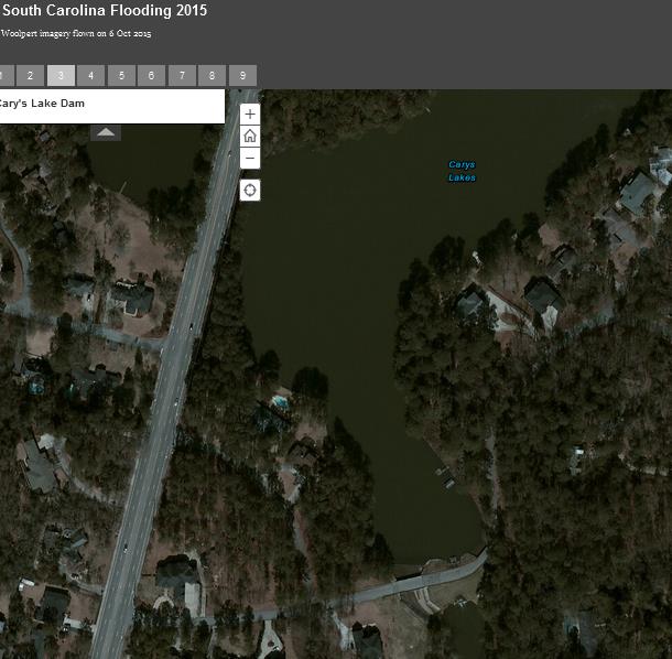
Cary Lake After
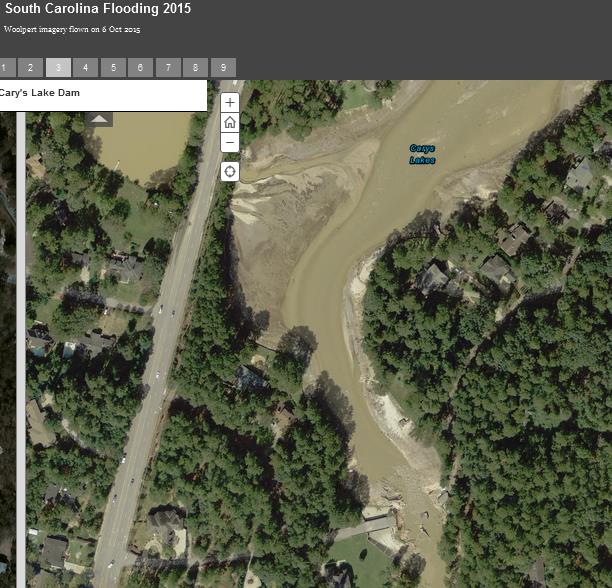
Pic sets include Cary Lake Dam failure; The water plant canal breach; the Beaver Dam one they're so worried about; the NorthLake/Rockyford Dam breach;Woodlake drive;Lake Katherine --they came real close to losing that one!!; Semmes Lake at Ft Jax and a quarry.
Another field day for a map geek like me!
just slide the middle bar to get the before/after pic
ESRI ARCGIS before/after flood aerials
Cary Lake Before
Cary Lake After
Pic sets include Cary Lake Dam failure; The water plant canal breach; the Beaver Dam one they're so worried about; the NorthLake/Rockyford Dam breach;Woodlake drive;Lake Katherine --they came real close to losing that one!!; Semmes Lake at Ft Jax and a quarry.
Another field day for a map geek like me!
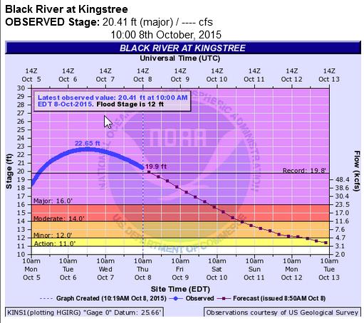
Good news is that the Black River in Kingstree has crested and is starting to go back down. Bad news it has broken the old record of 19.8 ft by
cresting 22.65 ft--close to a whopping 11 ft over flood stage. Pics I saw it was right under the HWY 52 bridge, and that was before it crested. This
Hwy is a Major trafic conduit in that area. My cuz said the other day that there was a huge propane tank that had come lose and floated downtream and
it was banging against the bridge!!! EM was hustling trying to figure out how to get it away from the bridge. And I'm not talking one of your
itty bitty camper tanks I'm talking about one like this: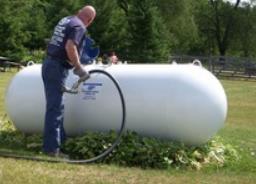
Still waiting at Santee--
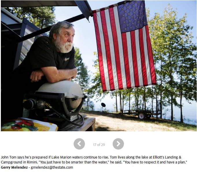
I like the way this guy thinks --gotta be smarter than the water!!
This where it's going to get interesting
Pissing contest between Haley' urging ppl to evac vs the Jamestown Fire Chief Schuler "Jamestown is safe"
Per Live 5 news
VS
THEY BOTH HAVE THEIR FACTS WRONG!!
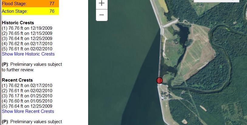
HALEY b/c: They are not going to allow the Lake Marion Santee dam to hit flood stage; they will keep it at just under at full pond like they always have, (just like they did for Lake Murray in Columbia)--it's already spilling over into the Santee River because the flood gates are open you ninny it has has 62 Tainter gates (wiki)
As you can see from the NWS Hydro page for Santee Dam with all the historic crests they have kept it just under flood stage of 77ft--They will open all those gates to preserve not only that dam infrastructure because that's the largest lake in SC but also the i95 bridge infrastructure crossing that lake -- that bridge goes out and SC is screwed. Most every thing down stream is swamp and a National forest preserve and it dumps into a coastal preserve area with little or no population--by design.
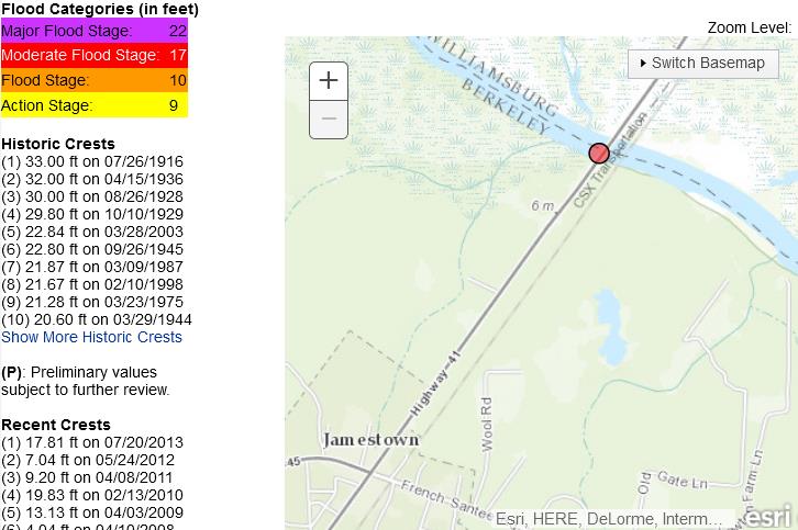
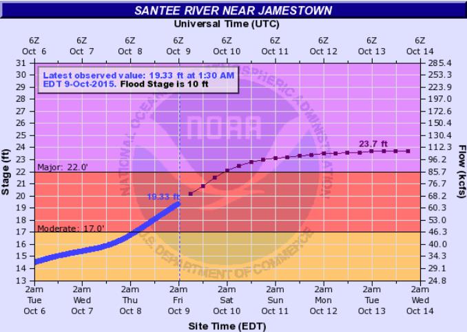
CHIEF SCHULER b/c: In the modern era after the dam was built in 1941/42 no you haven't had 24 ft and higher as evidence by the NWS Hydro page for the Jamestown gauge at Hwy 41. The top 4 crests were before the Santee Lakes & Dams were built, and prob before you were even born!! Max crest in modern era has been just under 23 ft. Santee is expected to crest just under 24 ft -- which will break the old modern era record by a foot or so.
Bottom line: these officials really need a crash course SC hydrology, history & geology!!!
I like the way this guy thinks --gotta be smarter than the water!!
This where it's going to get interesting
Pissing contest between Haley' urging ppl to evac vs the Jamestown Fire Chief Schuler "Jamestown is safe"
Per Live 5 news
[HALEY]"Flooding from the Santee is already an issue, but that's going to combine with Lake Marion hitting flood levels," Governor Hayley said. "If that spills over into the Santee that's going to be extremely problematic.
VS
"Jamestown is safe," Schuler said......We've had levels of 24 and above and we never had a situation where we had to leave Jamestown. The water has never come into Jamestown."
THEY BOTH HAVE THEIR FACTS WRONG!!
HALEY b/c: They are not going to allow the Lake Marion Santee dam to hit flood stage; they will keep it at just under at full pond like they always have, (just like they did for Lake Murray in Columbia)--it's already spilling over into the Santee River because the flood gates are open you ninny it has has 62 Tainter gates (wiki)
As you can see from the NWS Hydro page for Santee Dam with all the historic crests they have kept it just under flood stage of 77ft--They will open all those gates to preserve not only that dam infrastructure because that's the largest lake in SC but also the i95 bridge infrastructure crossing that lake -- that bridge goes out and SC is screwed. Most every thing down stream is swamp and a National forest preserve and it dumps into a coastal preserve area with little or no population--by design.
CHIEF SCHULER b/c: In the modern era after the dam was built in 1941/42 no you haven't had 24 ft and higher as evidence by the NWS Hydro page for the Jamestown gauge at Hwy 41. The top 4 crests were before the Santee Lakes & Dams were built, and prob before you were even born!! Max crest in modern era has been just under 23 ft. Santee is expected to crest just under 24 ft -- which will break the old modern era record by a foot or so.
Bottom line: these officials really need a crash course SC hydrology, history & geology!!!
WhoooHooo!!!!! ESRI ARCgis comes thru!!!!
Scalable SCDOT Detour map
Man this map is sooo cool.
I was thinking about this ALL day --Why hasn't some CPU genius programmer teamed up w/ARCgis and make a DECENT detour map??? We have the technology, just have to apply it!!
Scalable SCDOT Detour map
Man this map is sooo cool.
I was thinking about this ALL day --Why hasn't some CPU genius programmer teamed up w/ARCgis and make a DECENT detour map??? We have the technology, just have to apply it!!
edit on 9-10-2015 by SCGrits because: (no reason given)

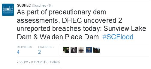
Two more dam breaches that were not reported earlier--Richland Co. New total dam failures = 16:
Gee ya think??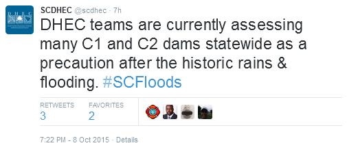
edit on 9-10-2015 by SCGrits because: (no reason given)
Gee ya think??
edit on 9-10-2015 by SCGrits because: (no reason given)
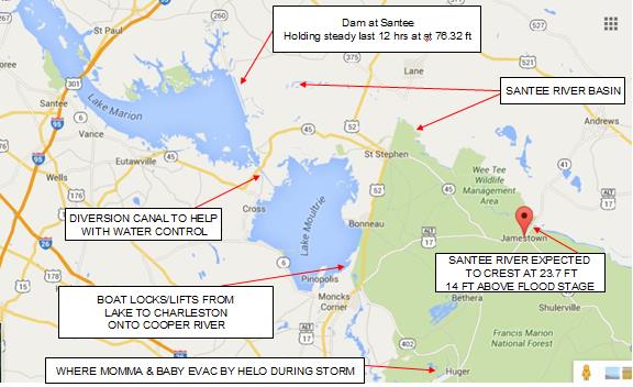
Just a little map I put together ref the Santee Lakes -Moultrie and Marion; Cooper and Santee Rivers. Any water higher than what the dam gates on
the Marion/Santee can handle will flow through the diversion canal into Lake Moultrie and on in through the locks to the Cooper on down into
Charleston. I suspect it will be high but manageable.
Via The State newspaper Q&A article 8 Oct
Extremely informative video clip from WLTX19 by Chad Silber in Lee Co on the anatomy of a dam failure
30 Acre Pond Washes Away Giant Patch of Road
Pond Dets:Name Clyburn Pond; Built in 1930; surface area - 2013 records say 24 acres - article says 30; Depth 15 ft; last inspection in 2008 (based on 2013 records); inspection frequency -every 3 yrs; private dam/pond; Rd/Hwy affected - Eddie Watkins Rd Lee Co
This is near the road I take down to my folks house. There are 2 large beaver ponds right up at the shoulder of the road on a curve on Hwy 341--I think this pond was just up stream. Fortunately this is area is ag fields and bottom land so not too much was affected other than crops and roadways.
The other pond he mentions they are watching is on Hwy 15 Ashwood Lake, in an area just North of Dalzel where I know they rec'd over 20 inches of rain.
Dets: Built in 1933; surface area 100 acres; depth 15 ft; last inspection in 2010 (based on 2013 records); inspection freq- 3 yrs; state owned -DNR; Hwy affected Hwy 15 Lee & Sumter Co.
Gotta go back to work -c ya
Are the area’s dams safe? It’s touch and go. Two more Richland County dams — one in the northeast and another in the southeast — were listed as breached Thursday. Nine neighborhood dams have failed in the Columbia area, more than half of the state total. About 70 dams are under observation, including at least three in Richland County. Good news? The damaged Beaver Dam Road and Spring Lake Dams are holding, according to the Gills Creek Watershed Association.
Extremely informative video clip from WLTX19 by Chad Silber in Lee Co on the anatomy of a dam failure
30 Acre Pond Washes Away Giant Patch of Road
Pond Dets:Name Clyburn Pond; Built in 1930; surface area - 2013 records say 24 acres - article says 30; Depth 15 ft; last inspection in 2008 (based on 2013 records); inspection frequency -every 3 yrs; private dam/pond; Rd/Hwy affected - Eddie Watkins Rd Lee Co
This is near the road I take down to my folks house. There are 2 large beaver ponds right up at the shoulder of the road on a curve on Hwy 341--I think this pond was just up stream. Fortunately this is area is ag fields and bottom land so not too much was affected other than crops and roadways.
The other pond he mentions they are watching is on Hwy 15 Ashwood Lake, in an area just North of Dalzel where I know they rec'd over 20 inches of rain.
Dets: Built in 1933; surface area 100 acres; depth 15 ft; last inspection in 2010 (based on 2013 records); inspection freq- 3 yrs; state owned -DNR; Hwy affected Hwy 15 Lee & Sumter Co.
Gotta go back to work -c ya
edit on 9-10-2015 by SCGrits because: (no reason given)
If ya'll are interested here's the thread I made in Board biz forum about the tech issue I'm having - I can't find my thread in the Fragile Earth
forum when I'm not logged in. Anyone else having that issue when they are not logged in?
ATS Link to Board Bussiness
I can't figure it out and I feel so dumb
ATS Link to Board Bussiness
I can't figure it out and I feel so dumb
originally posted by: SCGrits
a reply to: new_here
Thank you for that New Here.
It seems I'm having some tech issues posting and such, so I'm going to hold off posting till I figure out what's going on.
If you find anything new keep posting it!!
This website has today's flood news covering various topics, such as the I-95 closure...
ABC News
South Carolina officials say the foundations under some bridges on Interstate 95 have washed out, and they can't say when a 13-mile stretch of one of the most important highways on the East Coast will be open.
South Carolina Transportation Secretary Christy Hall said Friday that the problems are on 18 separate small bridges that go over the Black and Pocotaligo rivers and surrounding swampland in Clarendon County.
Hall says a contractor will begin to fix the foundations Saturday and work night and day. But she says she can't say how long that will take.
Other bridges in the area are also damaged, so travelers on I-95 that would normally drive 74 miles from Interstate 26 to Interstate 20 are having to take a 168-mile detour through Columbia.
edit on 10/9/2015 by new_here because: (no reason given)
a reply to: new_here
OMG!!!! I had not seen that!...Thanks you so very much for posting that!!!
That stretch is the Black River swamp ---home to my forefathers stretching all the way back to before the American Revolution so I know the area intimately.
This is bad...really really bad.
Makes me wonder how the i95 bridge over Lake Marion is doing?
South Carolina officials say the foundations under some bridges on Interstate 95 have washed out, and they can't say when a 13-mile stretch.......the problems are on 18 separate small bridges that go over the Black and Pocotaligo rivers and surrounding swampland in Clarendon County.
OMG!!!! I had not seen that!...Thanks you so very much for posting that!!!
That stretch is the Black River swamp ---home to my forefathers stretching all the way back to before the American Revolution so I know the area intimately.
This is bad...really really bad.
Makes me wonder how the i95 bridge over Lake Marion is doing?
new topics
-
In an Historic First, In N Out Burger Permanently Closes a Location
Mainstream News: 1 hours ago -
MH370 Again....
Disaster Conspiracies: 1 hours ago -
Are you ready for the return of Jesus Christ? Have you been cleansed by His blood?
Religion, Faith, And Theology: 4 hours ago -
Chronological time line of open source information
History: 5 hours ago -
A man of the people
Diseases and Pandemics: 6 hours ago -
Ramblings on DNA, blood, and Spirit.
Philosophy and Metaphysics: 7 hours ago -
4 plans of US elites to defeat Russia
New World Order: 8 hours ago -
Thousands Of Young Ukrainian Men Trying To Flee The Country To Avoid Conscription And The War
Other Current Events: 11 hours ago
top topics
-
Israeli Missile Strikes in Iran, Explosions in Syria + Iraq
World War Three: 15 hours ago, 17 flags -
In an Historic First, In N Out Burger Permanently Closes a Location
Mainstream News: 1 hours ago, 11 flags -
Thousands Of Young Ukrainian Men Trying To Flee The Country To Avoid Conscription And The War
Other Current Events: 11 hours ago, 7 flags -
Iran launches Retalliation Strike 4.18.24
World War Three: 14 hours ago, 6 flags -
12 jurors selected in Trump criminal trial
US Political Madness: 14 hours ago, 4 flags -
4 plans of US elites to defeat Russia
New World Order: 8 hours ago, 4 flags -
A man of the people
Diseases and Pandemics: 6 hours ago, 4 flags -
Chronological time line of open source information
History: 5 hours ago, 2 flags -
Are you ready for the return of Jesus Christ? Have you been cleansed by His blood?
Religion, Faith, And Theology: 4 hours ago, 2 flags -
MH370 Again....
Disaster Conspiracies: 1 hours ago, 1 flags
active topics
-
4 plans of US elites to defeat Russia
New World Order • 32 • : Oldcarpy2 -
12 jurors selected in Trump criminal trial
US Political Madness • 48 • : Xtrozero -
Thousands Of Young Ukrainian Men Trying To Flee The Country To Avoid Conscription And The War
Other Current Events • 22 • : Xtrozero -
Fossils in Greece Suggest Human Ancestors Evolved in Europe, Not Africa
Origins and Creationism • 69 • : Xtrozero -
In an Historic First, In N Out Burger Permanently Closes a Location
Mainstream News • 3 • : Bluntone22 -
George Knapp AMA on DI
Area 51 and other Facilities • 24 • : Raptured -
Marjorie Taylor Greene Files Motion to Vacate Speaker Mike Johnson
US Political Madness • 63 • : WeMustCare -
Do we live in a simulation similar to The Matrix 1999?
ATS Skunk Works • 23 • : JoelSnape -
Are you ready for the return of Jesus Christ? Have you been cleansed by His blood?
Religion, Faith, And Theology • 13 • : Cvastar -
MH370 Again....
Disaster Conspiracies • 4 • : Vermilion