It looks like you're using an Ad Blocker.
Please white-list or disable AboveTopSecret.com in your ad-blocking tool.
Thank you.
Some features of ATS will be disabled while you continue to use an ad-blocker.

Where did THAT come from?!?
page: 1share:
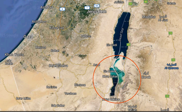
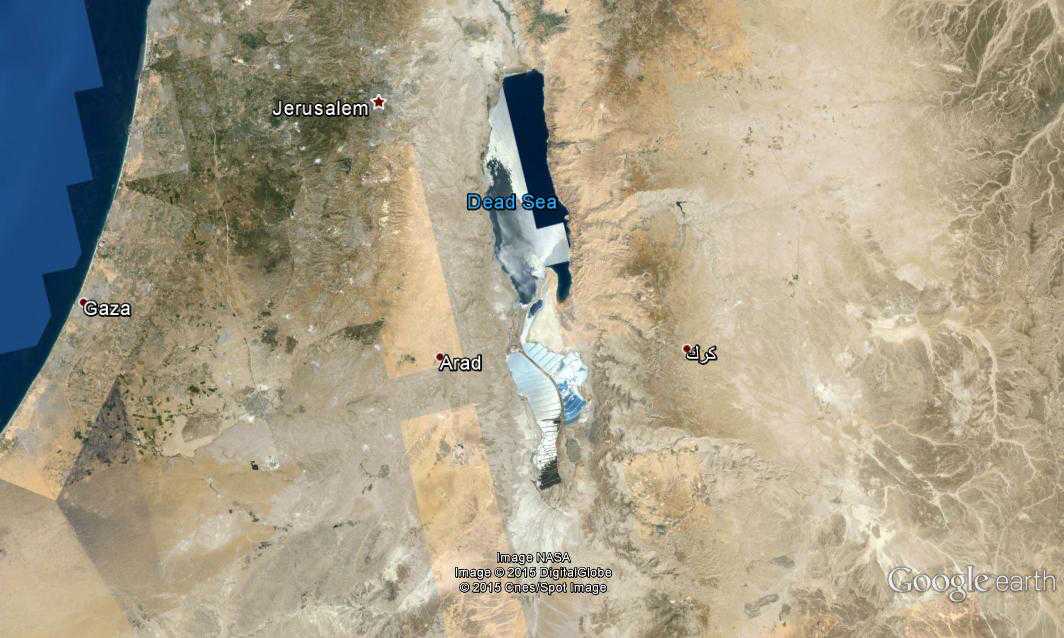
Anyone who knows how this obviously man-made sea made it into Google Maps? And what the bleep happened to the water level of the Dead Sea?
First image below is from Google Maps:
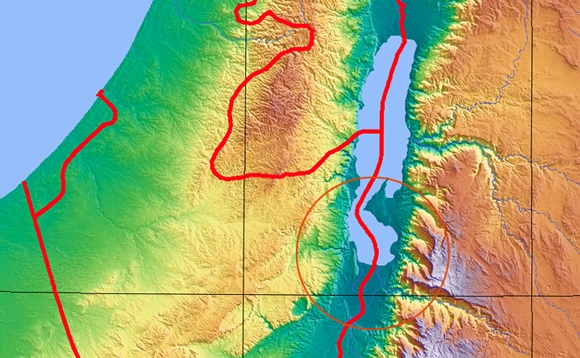
Compare to this map from 2007 (Wikipedia):
WTF?
First image below is from Google Maps:
Compare to this map from 2007 (Wikipedia):
WTF?
If your referring to the water drought and hot weather, than its water drought and hot weather. Many lakes/rivers/seas have "disappeared " cos of
over use/ climate changes throughout history. Nothing strange here. If you are referring to the multi layers of colours that tells me they are using
the local water source for agriculture / human consumption.
a reply to: Utnapisjtim
I have access to non-civilian satellite tech, below is a shot from within the last 6 hours in HD.
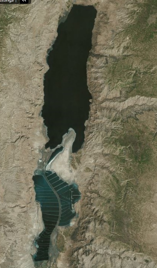
I have access to non-civilian satellite tech, below is a shot from within the last 6 hours in HD.
edit on 13-9-2015 by Sublimecraft because: (no reason given)
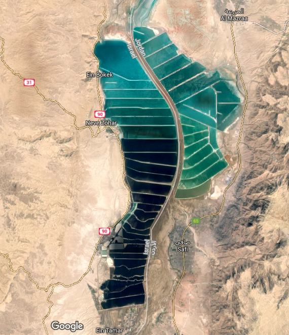
Saltworks. The flow into the Dead Sea has been trickling down for years, they predicted this would happen 20 years ago, it has been like this for a
while.
a reply to: Sublimecraft
Great. Thanks! Do you have access to pics of this same area in let's say 2007 (since the map in the OP is from '007)?
Great. Thanks! Do you have access to pics of this same area in let's say 2007 (since the map in the OP is from '007)?
a reply to: Utnapisjtim
That's the south part of the Dead Sea.
This is from Wikipedia:
Also from Wikipedia:
That's the south part of the Dead Sea.
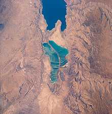
This is from Wikipedia:
View of salt evaporation pans on the Dead Sea, taken in 1989 from the Space Shuttle Columbia (STS-28). The southern half is separated from the northern half at what used to be the Lisan Peninsula because of the fall in level of the Dead Sea.
View of the mineral evaporation ponds almost 12 years later (STS-102). A northern and small southeastern extension were added and the large polygonal ponds subdivided.
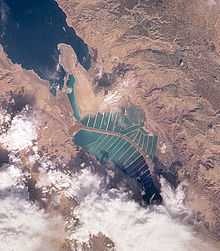
Also from Wikipedia:
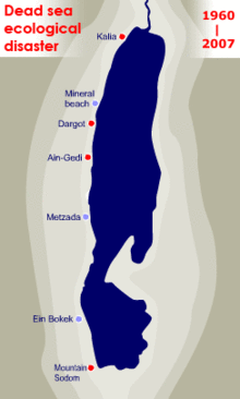
The dwindling water level of the Dead Sea
originally posted by: Utnapisjtim
a reply to: Sublimecraft
Great. Thanks! Do you have access to pics of this same area in let's say 2007 (since the map in the OP is from '007)?
Google Earth has.
This is from 14/06/2007
a reply to: Utnapisjtim
Download Google Earth, installed and then, when looking at it, just click the button with the clock
 and choose the date you want from the available dates that will appear.
Download Google Earth, installed and then, when looking at it, just click the button with the clock
a reply to: Sublimecraft
That is awesome. Not to derail, but i would love to see some of your satellite imagery of the area around Sandy Island. It was in between Australia and New Zealand, 23 km long and now it is gone from google maps and Earth.
Ill try and dig up coordinates..
Always good to see people pouring over satelitte imagery OP!
a reply to: NewzNose
Apparently it's a hi-res composite of what looks like thousands of pictures, I am unsure whether he means it can show 1:1 in HD, but that wouldn't amaze me. I would rise my brows though, possibly sigh and perhaps even shake my head slightly
Apparently it's a hi-res composite of what looks like thousands of pictures, I am unsure whether he means it can show 1:1 in HD, but that wouldn't amaze me. I would rise my brows though, possibly sigh and perhaps even shake my head slightly
a reply to: Utnapisjtim
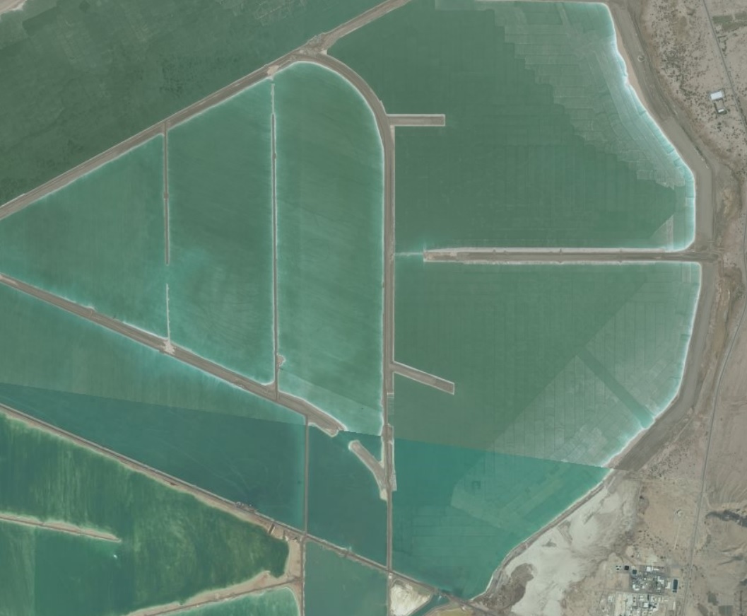
Hes talking about the one sublimecraft posted. The subdivided mineral evaporation ponds look like the water has been covered with parallel marker redactions. Especislly the top right section, where the beach dows not look like a natural water boundary. Of course this is just an optical illusion. It looks this way due to manmade steuctures and modifications.
Hes talking about the one sublimecraft posted. The subdivided mineral evaporation ponds look like the water has been covered with parallel marker redactions. Especislly the top right section, where the beach dows not look like a natural water boundary. Of course this is just an optical illusion. It looks this way due to manmade steuctures and modifications.
a reply to: 3n19m470
I said composite, I meant mosaic. The second pic there is made up of a giant mosaic, each tile showing hi-res pictures of the given area. Since they are taken at different times, the light appears to be different in every one, making the jig-saw zig-zag patterns. Am I correct or did I misunderstand completely?
I said composite, I meant mosaic. The second pic there is made up of a giant mosaic, each tile showing hi-res pictures of the given area. Since they are taken at different times, the light appears to be different in every one, making the jig-saw zig-zag patterns. Am I correct or did I misunderstand completely?
new topics
-
God's Righteousness is Greater than Our Wrath
Religion, Faith, And Theology: 5 minutes ago -
Electrical tricks for saving money
Education and Media: 3 hours ago -
VP's Secret Service agent brawls with other agents at Andrews
Mainstream News: 4 hours ago -
Sunak spinning the sickness figures
Other Current Events: 5 hours ago -
Nearly 70% Of Americans Want Talks To End War In Ukraine
Political Issues: 5 hours ago -
Late Night with the Devil - a really good unusual modern horror film.
Movies: 7 hours ago -
Cats Used as Live Bait to Train Ferocious Pitbulls in Illegal NYC Dogfighting
Social Issues and Civil Unrest: 8 hours ago -
The Good News According to Jesus - Episode 1
Religion, Faith, And Theology: 10 hours ago
top topics
-
Florida man's trip overseas ends in shock over $143,000 T-Mobile phone bill
Social Issues and Civil Unrest: 15 hours ago, 8 flags -
Cats Used as Live Bait to Train Ferocious Pitbulls in Illegal NYC Dogfighting
Social Issues and Civil Unrest: 8 hours ago, 8 flags -
VP's Secret Service agent brawls with other agents at Andrews
Mainstream News: 4 hours ago, 8 flags -
Former Labour minister Frank Field dies aged 81
People: 17 hours ago, 4 flags -
Bobiverse
Fantasy & Science Fiction: 15 hours ago, 3 flags -
HORRIBLE !! Russian Soldier Drinking Own Urine To Survive In Battle
World War Three: 12 hours ago, 3 flags -
Electrical tricks for saving money
Education and Media: 3 hours ago, 3 flags -
Nearly 70% Of Americans Want Talks To End War In Ukraine
Political Issues: 5 hours ago, 3 flags -
Sunak spinning the sickness figures
Other Current Events: 5 hours ago, 3 flags -
Late Night with the Devil - a really good unusual modern horror film.
Movies: 7 hours ago, 2 flags
active topics
-
VP's Secret Service agent brawls with other agents at Andrews
Mainstream News • 32 • : ThatSmellsStrange -
The Reality of the Laser
Military Projects • 46 • : Zaphod58 -
God's Righteousness is Greater than Our Wrath
Religion, Faith, And Theology • 0 • : randomuser2034 -
President BIDEN Vows to Make Americans Pay More Federal Taxes in 2025 - Political Suicide.
2024 Elections • 136 • : ImagoDei -
Electrical tricks for saving money
Education and Media • 3 • : Mike72 -
TLDR post about ATS and why I love it and hope we all stay together somewhere
General Chit Chat • 10 • : theshadowknows -
Why to avoid TikTok
Education and Media • 20 • : 5thHead -
How ageing is" immune deficiency"
Medical Issues & Conspiracies • 32 • : annonentity -
-@TH3WH17ERABB17- -Q- ---TIME TO SHOW THE WORLD--- -Part- --44--
Dissecting Disinformation • 657 • : daskakik -
HORRIBLE !! Russian Soldier Drinking Own Urine To Survive In Battle
World War Three • 30 • : DaRAGE