It looks like you're using an Ad Blocker.
Please white-list or disable AboveTopSecret.com in your ad-blocking tool.
Thank you.
Some features of ATS will be disabled while you continue to use an ad-blocker.

Extracting and animating data from the "UFO Video Captured By Homeland Security"
page: 10share:
originally posted by: raymundoko
I have about 4200 frames done so we have a good sample to pull from if we want to check it.
Sure. If you email me your work, I can just run a formula which takes your values from the values generated by WeAreOne's process - so any non-zero values will indicate differences for a quick check.
Thanks again for working on your column.
Thinking as I type here:
Having the whole path and every look at point is nice and all but it doesn't paint a complete picture. I'd still like to see which "look at" point corresponds with what plane location.
Having the whole path and every look at point is nice and all but it doesn't paint a complete picture. I'd still like to see which "look at" point corresponds with what plane location.
originally posted by: IsaacKoi
@WeAreOne : Could you briefly explain the "technique / program" you mention you developed. Apart from usefulness in relation to the remaining columns (some of which are unlikely to be essential), I'd be interested to learn any faster techniques since they potentially could be applied to other videos.
Sure! The technique / program is nothing too advanced, after all it really came down to manual entry and pressing buttons. The first thing I did was create a program that would load the spreadsheet for editing, and load the frame images in the same application, and any time I clicked on a specific row of that spreadsheet, or pressed the UP or DOWN keys on the keyboard, it would display the frame image corresponding to that row. On my quick computer I could hold the DOWN arrow and flip through the frames and the spreadsheet simultaneously almost as fast as the video, probably around 30 frames per second, with no lag.
After setting up the ideal environment I created two different tools. Since the coordinates of the aircraft are sequential, the first tool I developed simply stored the current value in a variable (in memory) and any time I pressed the NumPad5 button on my keyboard it would input that value into the correct column on the spreadsheet, and move to the next row (and load the next image). Any time the value increased or decreased (which on average was about every 10 frames) I would simply press either NumPad8, or NumPad2 to increase or decrease the value in memory, then again press NumPad5 to enter the new value. Using this technique was quite fast...
But I developed a faster way. Instead of inputting the value every frame, frame by frame, I created a tool that would "fill in the blanks" so to speak, and I would simply only input values when they visibly changed. So I would hold the down arrow key on my keyboard, and flip through the frames, and when I noticed the value changed I would press NumPad5 button to enter the new value in that row, and a function would go back and fill in the empty rows above with the previous value automatically , instantly. So for example, if I input the value 10 for frame 1, and by frame 25 the value changed to 11, I would enter the 11 in frame 25, and it automatically input value 10 in frame 2 through 24.
So essentially I was only inputting values when I noticed or detected a change, and the app would do the rest. Which was a much faster technique.
I can't imagine how you guys were doing it.
edit on 3-9-2015 by WeAre0ne because: (no reason given)
a reply to: WeAre0ne
I was doing something quite similar, though manual. My column was AD, the last in the top left co-ord line. I had the PDF open on one monitor, the spreadsheet on another. I hit or held "page down" until the number changed, holding that number and frame numbers in my mind. Then I'd go to the spreadsheet and copy and paste my answer while hitting the down arrow extremely rapidly.
And if you were wondering, I had YouTube open on my third monitor, LOL.
originally posted by: IsaacKoi
Challenge 2 : Plotting and animating some of that data (whether using After Effects, Cinem4D or otherwise) on a map or maps (whether sourced from Google Earth or otherwise).
Okay, just to get the ball rolling on Challenge 2, I have
(1) Updated and expanded the data spreadsheet, to incorporate the latest numbers provided by various people and to add columns which:
(a) include the time in seconds (including fractions of a second in relation to individual frames);
(b) the GPS coordinates for the aircraft and "target" (actually the ground seen behind the airborne aircraft) in digital format, i.e. converted from degrees/minutes/seconds.
The updated and expanded spreadsheet is at the usual link:
prrr.isaackoi.com...
(2) Created and started populating (by cutting and pasting from the above data spreadsheet) a spreadsheet to help convert the Excel spreadsheet data we have created so far to the KML file format used by Google Earth and other mapping software. This uses the spreadsheet tool created by "tek" that I referred to at the top of the previous page of this thread:
prrr.isaackoi.com...
(3) Used the spreadsheet in (2) above to create an initial KML file for use in Google Earth. This includes the coordinates for the aircraft and "target" for each frame, including the relevant frame numbers and timecodes in seconds. Obviously, this is just a first attempt at a KML file which needs to be checked for errors and probably have extra data added (e.g. to include the altitude of the aircraft and also to draw lines connecting the aircraft with the "target" for each frame) - but it should be enough to us all to start animating the data.
prrr.isaackoi.com...
Have fun with the above files (particularly the final one, i.e. the initial attempt at a KML file for animating in Google Earth or elsewhere). I'm off to bed.
More tomorrow.
edit on 3-9-2015 by IsaacKoi because: (no reason given)
originally posted by: IsaacKoi
prrr.isaackoi.com...
Have fun with the above files (particularly the final one, i.e. the initial attempt at a KML file for animating in Google Earth or elsewhere). I'm off to bed.
Dang! That .kml is bloated! It is setting a new Icon Style for every single placemark / frame! You only need to describe the Icon Style two times at the beginning of the file, one time for the Aircraft icons, and one time for the Target icons, and then simply refer to that style by name when creating a placemark. That .kml is describing the icon style 14 thousand + times. Eeek.
originally posted by: Ektar
I'm up to frame 1447 on the "AM" column.
I will wait ti hear from you in re to continuing.
Well, the data would still be useful. The only issue is whether we can implement WeAreOne's technique to speed things up. It may be that for us to implement that technique would take longer than simply finishing the job.
a reply to: IsaacKoi
Yeah, my app is not really in a state to share with others at the moment. It would be faster to just continue on without me. With that said I am going to do the AK column now. I can't wait for it.
Yeah, my app is not really in a state to share with others at the moment. It would be faster to just continue on without me. With that said I am going to do the AK column now. I can't wait for it.
edit on 3-9-2015 by WeAre0ne because: (no reason given)
Hey Isaac I stopped at after frame # 2073 at 9pm...needed a break.
I will try to do some more tomorrow.
Cheers
Ektar
I will try to do some more tomorrow.
Cheers
Ektar
Here is the completed AK column (aircraft altitude)...
files.abovetopsecret.com...
Right-click the link, click 'save link as', and when you save it, rename from .png to .txt or .csv
files.abovetopsecret.com...
Right-click the link, click 'save link as', and when you save it, rename from .png to .txt or .csv
edit on 4-9-2015 by WeAre0ne because: (no
reason given)
Here is the flight path with altitude factored in:
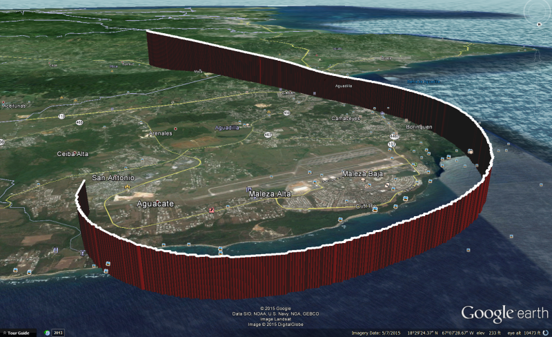
If you want to view this your self, here is a simple Google Earth KML file that utilizes a LineString:
files.abovetopsecret.com...
Right-click the link, click 'save link as', and when you save it, rename from .png to .kml and open in Google Earth.
If you want to view this your self, here is a simple Google Earth KML file that utilizes a LineString:
files.abovetopsecret.com...
Right-click the link, click 'save link as', and when you save it, rename from .png to .kml and open in Google Earth.
edit on 4-9-2015 by
WeAre0ne because: (no reason given)
a reply to: WeAre0ne
Just to make sure that we're not doing double work
I'm doing Column AK now and I'm pretty close to finish to be honest. ( Over 5800+ complete frames)
I believe it will be done by tomorrow or today after work.
But now im a bit confused...
If you done Column AK ? why I've been told to do so.
Anyways I'll be glad to have some explanation.
And should I finish Column AK or just give him up ?
The question referred to IsaacKoi or to anyone who can clarify the situation.
I've found that Column AL can be very useful and even necessary.
May I start complete it after AK ? or there is more important work to do by now ?
edit on 492015 by FederWBush because: (no reason
given)
a reply to: FederWBush
You do not need to do AK anymore. I started and finished AK today, and did it in about an hour of time using my program I developed. I provided the AK data a couple posts back.
I must apologize to you, Excallibacca, and raymundok for doing columns AD, AH, and AK in less time than it took for all 3 of you to do 1 column. lol.
edit on 4-9-2015 by WeAre0ne because: (no reason given)
I generated some more Google Earth KML. I have the aircraft placemarks, and the camera target placemarks, and a line connecting the two. I included
"TimeStamp" which embeds the date and time from the camera data. This causes Google Earth to display a time slider, and you can move the time slider
to animate the aircraft moving along its path through time.
Here are some screen shots of what it looks like as I move the time slider:
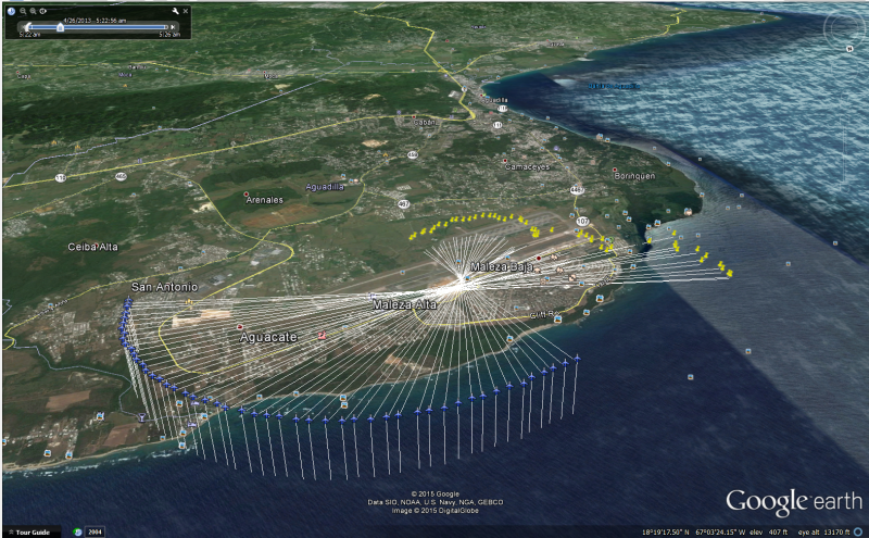
Looking at this closely, it really does seem the aircraft / camera was mainly focused on an area directly above the airfield the entire time. I don't think the UFO actually traveled anywhere far...
Well, take a look for your self. Here is the KML:
files.abovetopsecret.com...
Right-click the link above, click 'save link as', and when you save it, rename from .png to .kml and open in Google Earth.
NOTE: The KML above only includes snap shots of the aircraft and camera target from every second. It is not every frame.
-edit-
Quick video:
Here are some screen shots of what it looks like as I move the time slider:
Looking at this closely, it really does seem the aircraft / camera was mainly focused on an area directly above the airfield the entire time. I don't think the UFO actually traveled anywhere far...
Well, take a look for your self. Here is the KML:
files.abovetopsecret.com...
Right-click the link above, click 'save link as', and when you save it, rename from .png to .kml and open in Google Earth.
NOTE: The KML above only includes snap shots of the aircraft and camera target from every second. It is not every frame.
-edit-
Quick video:
edit on 4-9-2015 by WeAre0ne because: (no reason given)
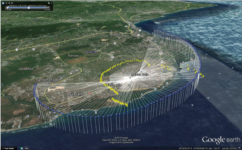
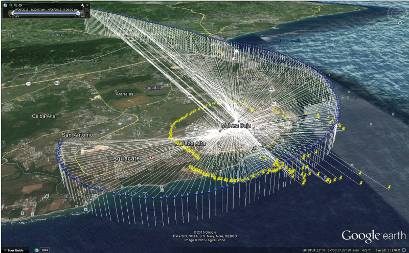
This is really good data! It shows exactly what part of the sky the camera was focused on. This is triangulation at its best. I am thinking that
the point where all the lines cross is where the UFO was floating.
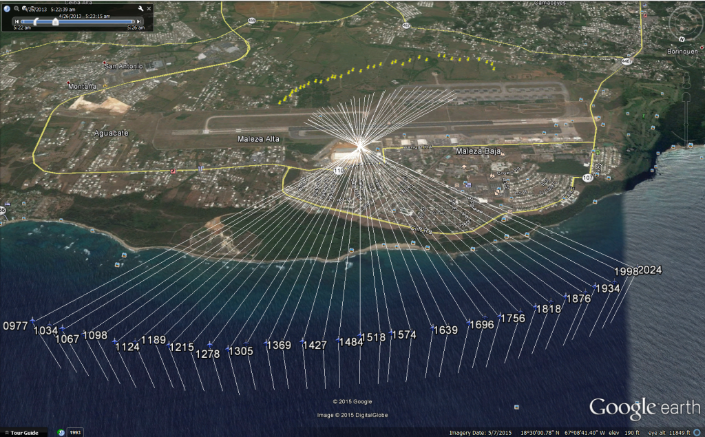
enlarge
enlarge
edit on 4-9-2015 by WeAre0ne because: (no reason given)
new topics
-
The good, the Bad and the Ugly!
Diseases and Pandemics: 40 minutes ago -
Russian intelligence officer: explosions at defense factories in the USA and Wales may be sabotage
Weaponry: 3 hours ago -
African "Newcomers" Tell NYC They Don't Like the Free Food or Shelter They've Been Given
Social Issues and Civil Unrest: 4 hours ago -
Russia Flooding
Other Current Events: 5 hours ago -
MULTIPLE SKYMASTER MESSAGES GOING OUT
World War Three: 6 hours ago -
Two Serious Crimes Committed by President JOE BIDEN that are Easy to Impeach Him For.
US Political Madness: 6 hours ago -
911 emergency lines are DOWN across multiple states
Breaking Alternative News: 6 hours ago -
Former NYT Reporter Attacks Scientists For Misleading Him Over COVID Lab-Leak Theory
Education and Media: 9 hours ago -
Why did Phizer team with nanobot maker
Medical Issues & Conspiracies: 9 hours ago -
Pro Hamas protesters at Columbia claim hit with chemical spray
World War Three: 9 hours ago
top topics
-
Go Woke, Go Broke--Forbes Confirms Disney Has Lost Money On Star Wars
Movies: 13 hours ago, 13 flags -
Pro Hamas protesters at Columbia claim hit with chemical spray
World War Three: 9 hours ago, 11 flags -
Elites disapearing
Political Conspiracies: 11 hours ago, 9 flags -
Freddie Mercury
Paranormal Studies: 14 hours ago, 7 flags -
African "Newcomers" Tell NYC They Don't Like the Free Food or Shelter They've Been Given
Social Issues and Civil Unrest: 4 hours ago, 6 flags -
A Personal Cigar UFO/UAP Video footage I have held onto and will release it here and now.
Aliens and UFOs: 11 hours ago, 5 flags -
Two Serious Crimes Committed by President JOE BIDEN that are Easy to Impeach Him For.
US Political Madness: 6 hours ago, 5 flags -
Russian intelligence officer: explosions at defense factories in the USA and Wales may be sabotage
Weaponry: 3 hours ago, 4 flags -
911 emergency lines are DOWN across multiple states
Breaking Alternative News: 6 hours ago, 4 flags -
Former NYT Reporter Attacks Scientists For Misleading Him Over COVID Lab-Leak Theory
Education and Media: 9 hours ago, 4 flags
active topics
-
Russian intelligence officer: explosions at defense factories in the USA and Wales may be sabotage
Weaponry • 35 • : Kurokage -
Elites disapearing
Political Conspiracies • 21 • : ntech620 -
-@TH3WH17ERABB17- -Q- ---TIME TO SHOW THE WORLD--- -Part- --44--
Dissecting Disinformation • 519 • : cherokeetroy -
Former NYT Reporter Attacks Scientists For Misleading Him Over COVID Lab-Leak Theory
Education and Media • 3 • : Hakaiju -
Two Serious Crimes Committed by President JOE BIDEN that are Easy to Impeach Him For.
US Political Madness • 9 • : Myhandle -
MULTIPLE SKYMASTER MESSAGES GOING OUT
World War Three • 15 • : cherokeetroy -
A Personal Cigar UFO/UAP Video footage I have held onto and will release it here and now.
Aliens and UFOs • 10 • : Hakaiju -
Revolution in advertising: the Russians launched a unique satellite
Science & Technology • 70 • : Kurokage -
The good, the Bad and the Ugly!
Diseases and Pandemics • 0 • : PrivateAngel -
African "Newcomers" Tell NYC They Don't Like the Free Food or Shelter They've Been Given
Social Issues and Civil Unrest • 5 • : sine.nomine