It looks like you're using an Ad Blocker.
Please white-list or disable AboveTopSecret.com in your ad-blocking tool.
Thank you.
Some features of ATS will be disabled while you continue to use an ad-blocker.

Tunnel , Appears Metal, On Mars North Pole
page: 1share:
This video has a lot of discussion of small surface impressions that could have been crafts landing and possible tracks in
the ground from these crafts. Wasn't very impressive. But, at about 5:53 in the video, something really jumped out. Looks like a tunnel. Then the view
pulls out and possibly this is part of a very large object buried not far under the ground. It was nice to see this after having just seen so many
videos of rocks that look like objects and are just, well, rocks. What do you think?
edit on 12-7-2015 by reldra because: (no reason
given)
Hm.m.m...That is very interesting..It just furthers the notion that we need to look underground on Mars if we want to find anything truly interesting.
Not just a couple of inches either but a couple of feet underground at the very least.
What you have in that video is someone's imagination running wild..
I think there are all sorts of odd things on Mars, mostly buried under the ground. Our past is always being dug up in deserts, forests and populated
areas that are being knocked down for various purposes.
Google Mars isn't really going to show anything that you could say with 100% certainty is alien. The same goes for the rovers they put up there. They're not going to show us anything that would be out of the ordinary for reasons unknown.
It's interesting to watch and it peaks your interest, but I wouldn't put much into it in terms of what's really up there.
a reply to: reldra
This?
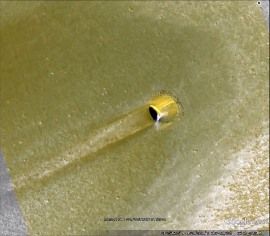
It looks like a small crater, with some wind created shapes making things look stranger.
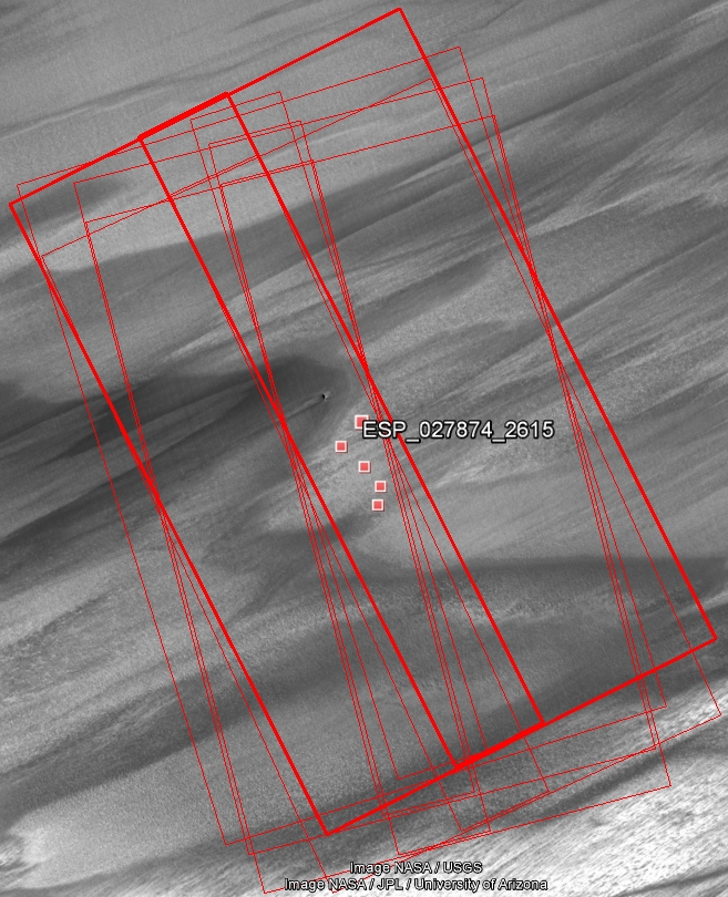
I found 5 HiRISE images of that crater, PSP_010086_2615, ESP_027492_2615, ESP_027874_2615, ESP_036485_2615 and ESP_036511_2615.
This?
It looks like a small crater, with some wind created shapes making things look stranger.
I found 5 HiRISE images of that crater, PSP_010086_2615, ESP_027492_2615, ESP_027874_2615, ESP_036485_2615 and ESP_036511_2615.
nope....the op is spot-on...
did you know we don't ever get to see anything as interesting and possibly surface passages to a lower level....admit that much or i'll be really suspicious .....already the suspicion runs strongly.
did you know we don't ever get to see anything as interesting and possibly surface passages to a lower level....admit that much or i'll be really suspicious .....already the suspicion runs strongly.
edit on 12-7-2015 by GBP/JPY because: our new King.....He comes right after a nicely done
fake one
originally posted by: reldra
a reply to: gortex Your picture looks nothing like a tunnel sticking out of something. Yours look like mounds or long rocks. Did you look at the time in the video posted?
Gortex's image are not mounds, but depressions...
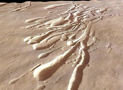
...i.e, they are "innies", not "outies". They are collapsed lava tubes. The lava tube was beneath, but the ceiling collapsed, creating a long depression/ravine.
It's a common optical illusion, such as when moon craters look like domes rather than craters.
edit on 7/12/2015 by Soylent Green Is People because: (no reason given)
a reply to: ArMaP
Thanks for linking the HiRISE imagery of that area. Their explanation is:
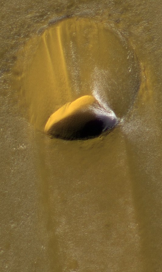
Here are the RGB (approximately true-colour) images taken through a span of several years, showing the wind-induced changes:
20 Sep 2008
07 June 2012
09 May 2014
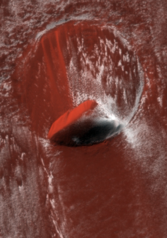
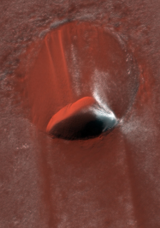
For the reference purposes, the image in the video is a false-colour Infrared/Red/Blue image, and here it is at the original resolution (and sharpened by me):
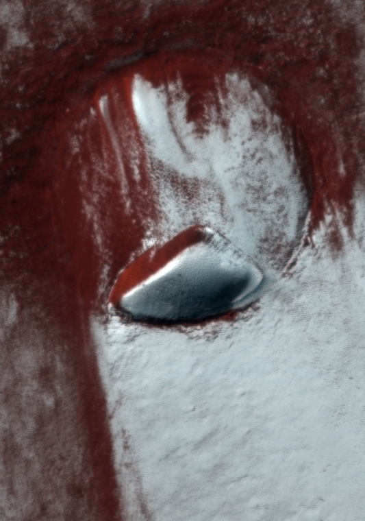
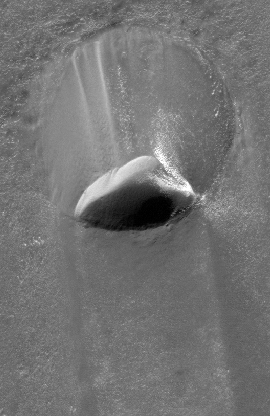
The black&white version (again sharpened by me) perhaps offers the clearest view:
(I rotated all these images to fit better in my post (as ATS only allows narrow but "tall" images)
Thanks for linking the HiRISE imagery of that area. Their explanation is:
In the center of the image lies an impact crater about 130 meters across (425 feet). Craters on the polar deposits are rare because the very active surface processes remove them quickly. This particular crater is likely to have been formed less than 100,000 years ago, which is very recent in geologic terms. Streaks of material emanating from the crater rim have been created as the ice and dust being transported across the surface by the wind encounters that obstacle.
Although its initial depth was probably about 25 m (80 ft), the crater has been infilled with ice and dust and is now quite shallow. However, in one portion of the crater (lower right), the fill material has been removed, creating a pit adjacent to the crater wall. This pit contains a fresh deposit of ice and may be in the beginning stages of being infilled again. These cycles of infilling and erosion will eventually erase the crater from the landscape.
Here are the RGB (approximately true-colour) images taken through a span of several years, showing the wind-induced changes:
20 Sep 2008
07 June 2012
09 May 2014
For the reference purposes, the image in the video is a false-colour Infrared/Red/Blue image, and here it is at the original resolution (and sharpened by me):
The black&white version (again sharpened by me) perhaps offers the clearest view:
(I rotated all these images to fit better in my post (as ATS only allows narrow but "tall" images)
edit on 12-7-2015 by wildespace because: (no
reason given)
originally posted by: gortex
Google Earth is not really a suitable tool for anomaly hunting.
Google Earth does have some usefulness, as it has HiRISE Image Browser under its Layers menu, which allows you to access the HiRISE images covering a partuclar area. This is how I believe ArMaP found them.
When someone posts about an "anomaly" and gives the coordinates, I use Google Earth to find the high-rez images (HiRISE for Mars, LROC for the Moon).
As the original high-rez imagery is complicated and sometimes difficult to access and browse through, Google Earth offers the simplest and quickest "first step" in finding something interesting. Too bad that the anomaly hunters don't go to the next step, which is accessing the high-rez imagery.
...which is what we're here for.
edit on 12-7-2015 by wildespace because: (no reason given)
a reply to: wildespace
I got the list of images from here, as I once saw that Google Earth didn't have all the images listed on their HiRISE layer.
I only use Google Earth to get the coordinates when I only have a photo and no coordinates.
I got the list of images from here, as I once saw that Google Earth didn't have all the images listed on their HiRISE layer.
I only use Google Earth to get the coordinates when I only have a photo and no coordinates.
originally posted by: ArMaP
a reply to: wildespace
I got the list of images from here, as I once saw that Google Earth didn't have all the images listed on their HiRISE layer.
I only use Google Earth to get the coordinates when I only have a photo and no coordinates.
I see all 5 images in Google Earth (see my screenshot above).
By the way, how do you get the coordinates when you only have a photo?
originally posted by: wildespace
I see all 5 images in Google Earth (see my screenshot above).
Yes, but as soon as I saw that there wasn't any image on Google Earth and there were two on the other site I start by going to that site.
By the way, how do you get the coordinates when you only have a photo?
It only works with photos that show a large area, I just look for a similar area. In the case of Mars, Viking photos, for example. I have done that mostly (or maybe only) with Moon photos.
new topics
-
University of Texas Instantly Shuts Down Anti Israel Protests
Education and Media: 51 minutes ago -
Any one suspicious of fever promotions events, major investor Goldman Sachs card only.
The Gray Area: 2 hours ago -
God's Righteousness is Greater than Our Wrath
Religion, Faith, And Theology: 7 hours ago -
Electrical tricks for saving money
Education and Media: 10 hours ago -
VP's Secret Service agent brawls with other agents at Andrews
Mainstream News: 11 hours ago
top topics
-
VP's Secret Service agent brawls with other agents at Andrews
Mainstream News: 11 hours ago, 10 flags -
Cats Used as Live Bait to Train Ferocious Pitbulls in Illegal NYC Dogfighting
Social Issues and Civil Unrest: 15 hours ago, 8 flags -
Nearly 70% Of Americans Want Talks To End War In Ukraine
Political Issues: 12 hours ago, 4 flags -
Electrical tricks for saving money
Education and Media: 10 hours ago, 4 flags -
Sunak spinning the sickness figures
Other Current Events: 12 hours ago, 3 flags -
Late Night with the Devil - a really good unusual modern horror film.
Movies: 14 hours ago, 2 flags -
Any one suspicious of fever promotions events, major investor Goldman Sachs card only.
The Gray Area: 2 hours ago, 2 flags -
The Good News According to Jesus - Episode 1
Religion, Faith, And Theology: 17 hours ago, 1 flags -
God's Righteousness is Greater than Our Wrath
Religion, Faith, And Theology: 7 hours ago, 0 flags -
University of Texas Instantly Shuts Down Anti Israel Protests
Education and Media: 51 minutes ago, 0 flags
active topics
-
Any one suspicious of fever promotions events, major investor Goldman Sachs card only.
The Gray Area • 6 • : ImagoDei -
Nearly 70% Of Americans Want Talks To End War In Ukraine
Political Issues • 30 • : Consvoli -
University of Texas Instantly Shuts Down Anti Israel Protests
Education and Media • 1 • : PorkChop96 -
Sunak spinning the sickness figures
Other Current Events • 10 • : crayzeed -
Reason of the Existence
The Gray Area • 20 • : belkide -
Black mirror, what happened.
Television • 20 • : seekshelter -
God's Righteousness is Greater than Our Wrath
Religion, Faith, And Theology • 25 • : andy06shake -
Russia Ukraine Update Thread - part 3
World War Three • 5730 • : Arbitrageur -
VP's Secret Service agent brawls with other agents at Andrews
Mainstream News • 43 • : Hakaiju -
Everest-sized ‘Devil comet’ Pons-Brooks Visible Now
Space Exploration • 17 • : Compendium