It looks like you're using an Ad Blocker.
Please white-list or disable AboveTopSecret.com in your ad-blocking tool.
Thank you.
Some features of ATS will be disabled while you continue to use an ad-blocker.

Guide to the FLAT EARTH
page: 23share:
originally posted by: Zaphod58
a reply to: NNN87
Because that line is the path that would be taken. If you were to try to go in a straight line from Florida to Japan, you couldn't do it without stopping for fuel. If you go in a circle route, you can make it.
That's why they take the circle route, i know, they have no option, read any journals from any explorer, north is the only thing and the only reference point one has, YES i know.
If it's a globe though, that distance is measured due to curvature, which i have not been able to locate since i set out to shut the door on this whole silly flat earth idea, and i have repeatedly failed.
originally posted by: ignorant_ape
a reply to: Zaphod58
actually - using the " flat earth map " its impossible to fly a commercial airliner with cargo and px between many destinations that in reality have non stop services
Below the equator, because that would be insane, on a globe they can do it, but i haven't seen one, north and south yes, maybe with some deviation east or west but below the equator no such flights, the distances are to great.
Now on a globe, there are so many shortcuts they could be taking but they don't for some reason, odd i think.
edit on 21-12-2016 by NNN87
because: (no reason given)
originally posted by: Zaphod58
a reply to: NNN87
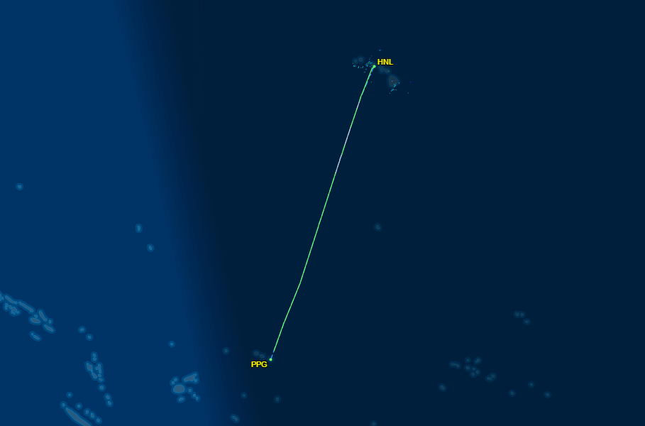
Then how do they fly to places like Pago Pago, or Sydney, or anywhere else South of the equator?
Well look at their routes, even trading ship routes, the never keep to the true east or west, they seem to constantly correct course more north, personal opinion, so they can see Polaris and shorten the gap, on a flat surface with an arrangement that of the equidistant projection it would make sense to do so, on a globe though, they could just go east straight or west, but they keep to the north and close to continents obviously.
edit on 21-12-2016 by NNN87 because: (no reason given)
NNN87 - WE HAVE ALREADY SHOWN THAT THE FLAT EARTH MAP IN IMPOSSIBLE SEVERAL DIFFERENT WAYS - IS IT DO WE HAVE TO KEEP BEATING THIS OBVIOUSLY DEAD
HORSE ?
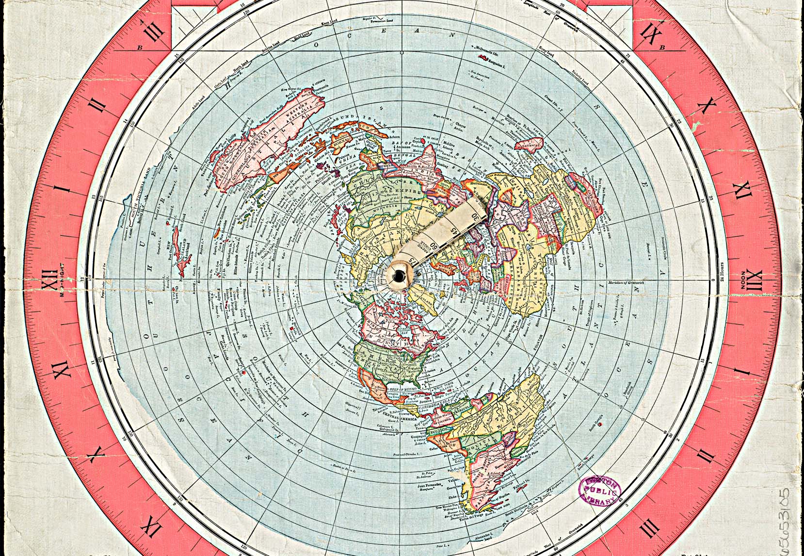
just for reference - this is a map that several previous flat eathers have claimed - as " accurate " :
a reply to: NNN87
Explain this then.
flightaware.com...
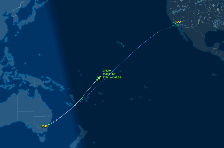
That sure looks like it's flying northeast, well away from any continents, in the southern hemisphere.
Nowhere near continents, to the Southern Hemisphere.
Explain this then.
flightaware.com...
That sure looks like it's flying northeast, well away from any continents, in the southern hemisphere.
Nowhere near continents, to the Southern Hemisphere.
a reply to: Zaphod58
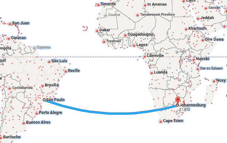
It also along with the image of the Sao Paulo to Jo'burg route demonstrates most easily why the idea of everything spreading out from North is silly. Notice that any great circle route in the southern hemisphere results in a vessel or aircraft travelling further SOUTH not further north. A great circle plotted in the Northern hemisphere will track further to the NORTH.
The image you posted shows the phenomena when you plot a great circle across both hemispheres which is essentially a wave shape on a mercator projection. The bit below the equator tends towards the south and the bit above tends towards the north.
All great circle routes will result in passing closer to what is known as the 'elevated pole' which is the pole nearest to you at any given time.
If the flat earth theory is to be believed then there isn't a specific point known as the south Pole. The presence of the constellation Crux Australis (The southern cross) which is analogous to the north star (Polaris) also disproves the theorem. There is no way that a fixed south Pole reference point works on a flat earth map.
originally posted by: NNN87
originally posted by: Zaphod58
a reply to: NNN87
Then how do they fly to places like Pago Pago, or Sydney, or anywhere else South of the equator?
Well look at their routes, even trading ship routes, the never keep to the true east or west, they seem to constantly correct course more north, personal opinion, so they can see Polaris and shorten the gap, on a flat surface with an arrangement that of the equidistant projection it would make sense to do so, on a globe though, they could just go east straight or west, but they keep to the north and close to continents obviously.
Cargo vessels don't always follow the shortest distance route particularly in the southern hemisphere. As has been told to you several times, the shortest distance between two points is the great circle route (which on a mercator chart is a curve and on a gnomonic projection is a straight line) results in an overall higher latitude (either to the north or to the south dependent upon hemisphere). The southern oceans are horrendous to sail in due to the wind and waves. They result in much greater fuel consumption, Greater mechanical wear, cargo damage and crew/passenger discomfort. The choice of route for a ship is generally made on the basis of economics and southern great circles just ain't economic (there is a compromise solution known as a composite great circle).
originally posted by: ignorant_ape
a reply to: NNN87
1 polaris cannot be observed from south of the equartor
2 - theres another flat earth impossible flight :
sao palo brazil to johanassburg RSA - non stop scheduled service
it cannot be done on the flat earth map
Huh, those flights are new, started in May 2016, but either way, those two locations on an equidistant projection are actually.not that far away from another, assuming that line that is drawn for the flights path is fake, and the plane instead will stay close to the equator and only after reaching Africa's continent it will make its way south. But we have to know the exact path it actually takes, but yeah its plausible.
originally posted by: ignorant_ape
just for reference - this is a map that several previous flat eathers have claimed - as " accurate " :
Its the equidistant projection, not a flat earth projection, but it's the most relative image we have for the earth being flat, if that is the case. And yes, i actually is a very precise map, it is one of the functions said map.
Now if we had a real picture of our home, yeah, we use that.
This is what i mean, you people are making things so complicated for no reason. Finding anything and i mean anything to keep your grip on what you believe to be the truth, EXPLAIN TO ME, why i can see objects beyond the supposed curvature??
originally posted by: NNN87
originally posted by: ignorant_ape
just for reference - this is a map that several previous flat eathers have claimed - as " accurate " :
Its the equidistant projection, not a flat earth projection, but it's the most relative image we have for the earth being flat, if that is the case. And yes, it is actually a very precise map, it is one of the functions of that map.
Now if we had a real picture of our home, yeah, we use that.
This is what i mean, you people are making things so complicated for no reason. Finding anything and i mean anything to keep your grip on what you believe to be the truth, EXPLAIN TO ME, why i can see objects beyond the supposed curvature??
??not sure what happened here. Sorry.
edit on 21-12-2016 by NNN87 because: (no reason given)
NVM. The headache is getting too bad.
edit on 12/21/2016 by Zaphod58 because: (no reason given)
a reply to: Zaphod58
The headache is strong because you are jot getting something, those flights do make sense on the equidistant projection, you keep showing me models which are known to be inaccurate in continent proportions.
Did you guys even read about the Equidistant projection, its purpose and all? Planes are irrelevant, they work on both models, since we don't really have, and i mean all of us here, don't have an accurate map, so you guys and anyone else can draw lines all day, there are things i am seeing, which i should not be able to. Anyone care to explain THAT to me.
There is no Flat Earth map, no one has a picture of it, the only reason i use the equidistant projection as reference, because it is the most accurate map for pin pointing your target locations with extremely good precision, where the globe projection or any other fails. (Sorry, for radios)
Lastly, the southern cross is known, and i mean KNOWN to travel along the horizon, it is a terrible reference point, it will still take you south, but you will end up at a different destination, that is known if you read on it.
:
edit on 21-12-2016 by NNN87 because: (no reason given)
edit on 21-12-2016 by NNN87 because: (no reason given)
a reply to: NNN87
why - explain why no one is able to make a flat earth map - it SHOULD be the easiest map projection to make - an alledged flat plne rendered at a useanle scale in 2d - nothing could be simpler
as for your other claims - not sure id dishonesty or delusion - can i opt for a mix of both
if you think sao paulo to johanasburg is a " short distance " you are either lying for your adjenda - or utterly mad
There is no Flat Earth map, no one has a picture of it,
why - explain why no one is able to make a flat earth map - it SHOULD be the easiest map projection to make - an alledged flat plne rendered at a useanle scale in 2d - nothing could be simpler
as for your other claims - not sure id dishonesty or delusion - can i opt for a mix of both
if you think sao paulo to johanasburg is a " short distance " you are either lying for your adjenda - or utterly mad
originally posted by: ignorant_ape
a reply to: NNN87
There is no Flat Earth map, no one has a picture of it,
why - explain why no one is able to make a flat earth map - it SHOULD be the easiest map projection to make - an alledged flat plne rendered at a useanle scale in 2d - nothing could be simpler
as for your other claims - not sure id dishonesty or delusion - can i opt for a mix of both
if you think sao paulo to johanasburg is a " short distance " you are either lying for your adjenda - or utterly mad
Again with the planes, its roughly an 8 hour flight, some booking flight say 9:30 some say 8:30 hour flight, i don't man, that's a lot of time difference, i seriously have no idea what that has to do with the shape of our beloved home.
That's why i use the equidistant projection, its the best reference I have, that's your answer, i dont have more then that when it comes to as to why there are no accurate maps, why no one made one, your asking the wrong person.
new topics
-
Why did Phizer team with nanobot maker
Medical Issues & Conspiracies: 1 minutes ago -
Pro Hamas protesters at Columbia claim hit with chemical spray
World War Three: 21 minutes ago -
Elites disapearing
Political Conspiracies: 2 hours ago -
A Personal Cigar UFO/UAP Video footage I have held onto and will release it here and now.
Aliens and UFOs: 2 hours ago -
Go Woke, Go Broke--Forbes Confirms Disney Has Lost Money On Star Wars
Movies: 4 hours ago -
Freddie Mercury
Paranormal Studies: 4 hours ago -
Nirvana - Immigrant Song
Music: 9 hours ago -
British TV Presenter Refuses To Use Guest's Preferred Pronouns
Education and Media: 10 hours ago
top topics
-
British TV Presenter Refuses To Use Guest's Preferred Pronouns
Education and Media: 10 hours ago, 16 flags -
Go Woke, Go Broke--Forbes Confirms Disney Has Lost Money On Star Wars
Movies: 4 hours ago, 11 flags -
Trump To Hold Dinner with President of Poland At Trump Tower Tonight
2024 Elections: 12 hours ago, 8 flags -
Tucker Carlson interviews Christian pastor from Bethlehem.
Middle East Issues: 12 hours ago, 7 flags -
Elites disapearing
Political Conspiracies: 2 hours ago, 7 flags -
A family from Kansas with six children moved to the Moscow region
Other Current Events: 15 hours ago, 6 flags -
Pro Hamas protesters at Columbia claim hit with chemical spray
World War Three: 21 minutes ago, 6 flags -
A Personal Cigar UFO/UAP Video footage I have held onto and will release it here and now.
Aliens and UFOs: 2 hours ago, 5 flags -
Freddie Mercury
Paranormal Studies: 4 hours ago, 5 flags -
Nirvana - Immigrant Song
Music: 9 hours ago, 4 flags
active topics
-
Pro Hamas protesters at Columbia claim hit with chemical spray
World War Three • 3 • : Lumenari -
Why did Phizer team with nanobot maker
Medical Issues & Conspiracies • 0 • : annonentity -
Go Woke, Go Broke--Forbes Confirms Disney Has Lost Money On Star Wars
Movies • 14 • : budzprime69 -
A family from Kansas with six children moved to the Moscow region
Other Current Events • 73 • : BernnieJGato -
-@TH3WH17ERABB17- -Q- ---TIME TO SHOW THE WORLD--- -Part- --44--
Dissecting Disinformation • 510 • : fringeofthefringe -
Candidate TRUMP Now Has Crazy Judge JUAN MERCHAN After Him - The Stormy Daniels Hush-Money Case.
Political Conspiracies • 317 • : Annee -
Abortions in first 12 weeks should be legalised in Germany, commission says
Medical Issues & Conspiracies • 26 • : Sookiechacha -
Nirvana - Immigrant Song
Music • 6 • : watchitburn -
Elites disapearing
Political Conspiracies • 11 • : nerbot -
Are the 'Abrahamic Religions' all Really the Worshipping the Same Abrahamic God?
Conspiracies in Religions • 190 • : Consvoli