It looks like you're using an Ad Blocker.
Please white-list or disable AboveTopSecret.com in your ad-blocking tool.
Thank you.
Some features of ATS will be disabled while you continue to use an ad-blocker.

The Phenomenon of Eagle, Alaska and a Look at the New Madrid
page: 115
share:
These are the next two chapters in my book, Fever Rising. The first one here takes a look at the phenomenon of Eagle, Alaska, volcanic area claimed
not to be volcanic, and the second one looks at the seismic activity of the New Madrid area over recent years. To read the first 26 chapters in a
series of threads, check out this link and then follow the links at the beginnings of the threads to go back
Extreme Weather Events just getting started
Or, here is the first thread in the series to start at the beginning. The Mystery of the Clintonville Booms
Chapter 27: The Phenomenon of Eagle, Alaska
It began with reports of a loud boom on September 7, 2012 heard throughout the small Alaskan village of Eagle. It took two weeks for the mystery of the boom to be solved when a fire was spotted 25 miles north east of Eagle at a small remote mountain top. That was on October 10. On October 15, the fire had spread to 15 acres and after a significant snowfall, the fire still burned. Furthermore, it started to emit steam and sulfur smells.
It took until the next spring for anyone to get on the ground at the sight. That was a geologist from the National Park Service, other than that, the government said because of sequester and budget cuts, it was unable to investigate the fire that had been burning ever since it was discovered.
Officials from the NPS and the United States Geological Service don’t believe that the mysterious slump is a volcano or any thermal event of any kind, although it appeared to be one from above. They suspect it’s a shale oil rock deposit.
In a news report a forest ranger described the event as possibly a thousand feet deep if it is indeed an oil shale. He said that it could have been burning for a long time under ground, possibly from a lightning strike years ago and finally burned enough to cause the crater.
There is an active fault in the area. Also, whenever the wind is right, the 100 residents of Eagle can smell noxious sulfuric smoke all over town. The residents are worried because they still haven’t been told exactly what the crater is. They are worried about the toxicity of the fumes they occasionally have to suffer through. The area is very remote. Eagle is so small and far removed that there is only one road in to the village and that road is closed off for the winter months. The 100 residents hunker down for the long cold winters.
The location of the mysterious slump is so remote that it will take a mission to examine the hole, thus the budget cuts and no money to investigate. Local geologists and rangers had been to the sight in the summer of 2013 to take measurements. Here is some information about the crater;
CBS News, Aug. 28, 2013
Pat Sanders, a ranger who works in the Yukon-Charley Rivers National Preserve, said measurements have been taken showing there's extreme heat coming out of fissures in the ground.
"[It's] 285 degrees Celsius and that one wasn't even smoking," Sanders said. "There's a lot of heat involved and it's still very, very active and we don't know [what] it's going to do or how far it extends but we've taken a progression of pictures throughout since October of last year and the changes in the landscape are just dramatic."
Environmental protection agencies have promised air monitors for people in Eagle. They say the sulphur dioxide gases that drift into town are raising health concerns.
Sanders said the fire started with an underground explosion last fall but the effects are visible on the surface. The fire zone used to cover about 5 acres, but it's grown to about 30 after burning all year, Sanders says.
"[There's] huge orange rocks steaming and smoking and some yellow sulphur rock. It actually looks like a bomb has gone off somewhere."
Aerial photos suggest a volcano forming but geologists say it's likely an underground shale gas fire. Sanders said the air monitors will be welcome, although there's no indication when they might be coming.
"We're happy for that because we don't know how much sulphur dioxide on windy days we are actually breathing.”
What perplexes me about this story is the amount of sulfur dioxide smells that may be drifting into this town. This is something that is emitted in great amounts from volcanoes, yet they deny that it’s a volcano in the forming stages. At the same time, they haven’t really given an answer to why they eliminate the volcano possibility and stick to the claim that it’s most positively an oil shale.
At any rate, an Alaskan environmental health official was giving the residents some advice on what to do to protect themselves from toxic gases. There are some precautions they should take on certain windy days and limit their outdoor exposure, especially asthmatics and elderly.
The Mayor of Eagle expressed his concern about the winter months when the residents have to hunker down and the temperatures occasionally drop down to 40 degrees below zero. He said that cold, often polluted, air gets trapped underneath warmer air in the winter months and this inversion will cause the residents to be stuck with the toxic fumes from the fire. He cited the city of Fairbanks as having a smog over it in the winter months because of this temperature inversion and that its one of the dirtiest cities in America.
In the summer months, the sulfuric air will continue to blow through but in the winter months it’s very possible that the toxic fumes will get trapped in the village and linger there for the residents to breathe in.
What’s most interesting about this phenomenon is that Eagle, Alaska isn’t alone in experiencing a mysterious slump. Another hole opened up in Rome overnight on August 24, 2013, with a cloud of smelly gas, but this one was confirmed to be volcanic in nature. Here is an article about the commonality of both craters. This article describes a bit more about the more likely idea that the Eagle, Alaska caldera is really volcanic in nature.
What do smoking geyser in Italy and smoldering mountain in Alaska have in common?
Examiner.com, Aug. 30, 2013
What do the mysterious smoking volcanic hole at Rome's Fiumicino Airport and the mysterious smoldering mountain top in Alaska have in common? For one thing, they both appeared suddenly – one overnight and the other with a loud boom.
Rome, Italy
On Aug 24, 2013, a volcanic geyser erupted overnight at Rome’s Fiumicino Airport, one of Europe’s busiest airports. A crater, measuring about 6 ft. wide by 3 ft. deep, formed in the middle of a roundabout, close to the perimeter fence -- less than 900 yards from the end of a runway. Hot clouds of smelly gas spewed 15 feet into the air from the hole.
Initial reports suggested the stench is from rotting organic matter trapped underground; however, one expert believes the stench is from a toxic mix of carbon dioxide, hydrogen sulfide, and methane.
Continued...
Eagle, Alaska
Late one Sept day last year, Pat Sanders, a ranger at Yukon-Charley Rivers National Preserve in Interior Alaska, heard a distant explosion. A few weeks later, a fire was spotted about 25 miles northeast of Eagle, a town of less than 100. An over flight of the area on Oct 15, revealed a jagged, black smoldering pit on a Windfall Mountain peak. The fire, which has burning ever since, has spread from 5 acres to about 30 acres.
Sanders has taken a progression of pictures since Oct, and she finds the changes in the landscape to be dramatic. The caldera, dubbed the “Tatonduk slump and fire,” has tripled in size since it was first photographed.
Aerial photos suggest that a volcano is forming. Huge orange rocks and yellow sulfur stream smoke, and extreme heat rises from fissures in the ground. National Park Service geologist Linda Stromquist, measured the temperature at one fissure at 545 deg F.
Both Italy and Alaska sit on tectonic plate boundaries, places of volcanic activity where plates are pushed together or pulled apart. Italy contends with the Eurasian and African Plate boundary, while Alaska is on the receiving end of the Pacific Plate as it slides laterally past southeast Alaska and collides with the North American Plate.
For how long this slump in Alaska could continue to burn remains a mystery. How long will the fire burn? No one seems to know. It could be that the small village may become uninhabitable if the fire grows. Eagle could become a small remote Alaskan ghost town.
Chapter 28: The Very Volatile New Madrid
I can remember through the years growing up in the Midwest, when you heard about an earthquake in our region, you were like, whoa, really? Now, not so much, they are happening more and more often in the New Madrid zone that it barely makes the news anymore. A small 2.7 quake hit near Benton, IL which is in the far southern part of the state in early March, 2013. The quake caused little to no damage and was in a very rural area.
Chicago Tribune, March 11, 2013
A small earthquake measuring 2.7 magnitude hit near Benton in southern Illinois this morning but appears to have done little, if any, damage in the rural area.
The Franklin County Sheriff’s office said it had gotten no reports of injuries or damages. The quake hit to the north and west of what is called the New Madrid seismic zone. The last strong quake to hit southern Illinois was in April 2008, when a 5.2 magnitude quake struck near West Salem, affecting areas including Mount Carmel, about 80 miles east of Benton.
A mild earthquake, with a 3.8 magnitude, hit the Chicago area on Feb. 10, 2010.
Over the past couple of years, there have been a string of these small tremors throughout the New Madrid region. Just a few months before this March quake in Benton, a 4.3 quake struck in Kentucky that was felt across 12 states. Two weeks after that, a 3.6 rattled Mt. Carmel, IL. The same night that the Illinois quake struck, a smaller 2.9 was felt in Edmond, OK. The Kentucky quake was felt in Knoxville where it even set off some panic as homes rattled and walls shook. All three of these quakes were shallow, Kentucky’s was just over 12 miles deep, and that’s why it was felt over such a wide area.
There have been a lot of tremors along the fault line recently, even two small 1.7 tremors in New Madrid, MO itself on March 9, 2013. Trumann, AR had a small 2.3 two days after that while it also felt a 3.6 in the same spot on February 23. In the same week that all these other tremors were cropping up, MO and AR had five small quakes along the New Madrid fault.
The map on the next page shows 309 earthquakes in the 6-month period prior to March 12, 2013 in the Central United States. That’s a lot of quakes. Some of these are surely hydraulic fracking quakes, while many are not and they are close to the New Madrid fault line.
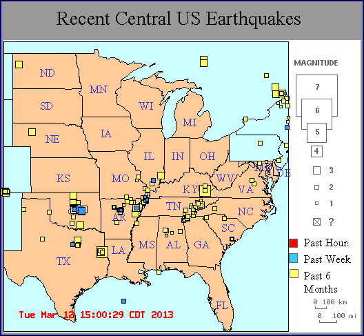
folkworm.ceri.memphis.edu...
So what exactly is the New Madrid fault? It’s a fault line that’s six times the size of the famed San Andreas Fault in California. The New Madrid covers parts of Illinois, Indiana, Missouri, Arkansas, Mississippi, Kentucky and Tennessee. Alabama and Oklahoma may also be a part of this according to FEMA.
The New Madrid experienced four large quakes in 1811-12 that were all 7.0 or larger, one of them caused the Mississippi River to run backwards, was felt as far away as Boston and each quake caused large fissures to open up in the earth. The New Madrid had another large quake in 1968 in Dale, IL that registered 5.4. Otherwise, it’s been quiet, until these past couple of years.
Many strange occurrences ensued lately through this region of the country, from as far south as Louisiana and its sinkholes up to Arkansas and their mass animal die-offs (we all remember Beebe, AR, and the birds falling from the sky) up into Tennessee where numerous reports of strange sky noises and sonic booms, not to mention animal die-offs were reported. Throughout the New Madrid area over the past few years, there have been constant reports of the strange sky noises and unexplained sonic booms. There were many fish and animal die-offs that made headlines including over 100,000 fish washing ashore along an Arkansas River and the 3,000 blackbirds in Beebe, and another 500 birds in Louisiana. In the period between September of 2012 and March of 2013, there were over 500 small earthquakes in central Arkansas alone.
Think about how many of these fissures from the tectonic movement are releasing methane gas in the central part of the US, which may be resulting in the strange sky noises, sonic booms, and mass animal die-offs. I might also note that the area from Oklahoma to Virginia, across the central part of the United States, is the most active part of the country for fireball sightings.
One geologist said that he believes the new activity along the New Madrid may be the direct result of the BP oil spill. He postulated the New Madrid is tied directly to deeply buried tectonics in the Gulf of Mexico.
This geologist, Jack Reed, is a retired Texaco geologist-geophysicist. He has been studying the geology of the Gulf of Mexico for over 40 years and said, “This entire zone through the United States is suffering some type of tectonic activity that I believe is tied to the deeply buried tectonics of the Gulf of Mexico.”
But could it have been the BP spill? It’s quite possible. Some also believe that this spill may also be indirectly tied to the Louisiana sinkhole in Assumption Parish. Then what about the Gulf of Mexico dead zone at the mouth of the Mississippi? You remember the dead zone that we discussed in an earlier chapter?
Continued...
Late one Sept day last year, Pat Sanders, a ranger at Yukon-Charley Rivers National Preserve in Interior Alaska, heard a distant explosion. A few weeks later, a fire was spotted about 25 miles northeast of Eagle, a town of less than 100. An over flight of the area on Oct 15, revealed a jagged, black smoldering pit on a Windfall Mountain peak. The fire, which has burning ever since, has spread from 5 acres to about 30 acres.
Sanders has taken a progression of pictures since Oct, and she finds the changes in the landscape to be dramatic. The caldera, dubbed the “Tatonduk slump and fire,” has tripled in size since it was first photographed.
Aerial photos suggest that a volcano is forming. Huge orange rocks and yellow sulfur stream smoke, and extreme heat rises from fissures in the ground. National Park Service geologist Linda Stromquist, measured the temperature at one fissure at 545 deg F.
Both Italy and Alaska sit on tectonic plate boundaries, places of volcanic activity where plates are pushed together or pulled apart. Italy contends with the Eurasian and African Plate boundary, while Alaska is on the receiving end of the Pacific Plate as it slides laterally past southeast Alaska and collides with the North American Plate.
For how long this slump in Alaska could continue to burn remains a mystery. How long will the fire burn? No one seems to know. It could be that the small village may become uninhabitable if the fire grows. Eagle could become a small remote Alaskan ghost town.
Chapter 28: The Very Volatile New Madrid
I can remember through the years growing up in the Midwest, when you heard about an earthquake in our region, you were like, whoa, really? Now, not so much, they are happening more and more often in the New Madrid zone that it barely makes the news anymore. A small 2.7 quake hit near Benton, IL which is in the far southern part of the state in early March, 2013. The quake caused little to no damage and was in a very rural area.
Chicago Tribune, March 11, 2013
A small earthquake measuring 2.7 magnitude hit near Benton in southern Illinois this morning but appears to have done little, if any, damage in the rural area.
The Franklin County Sheriff’s office said it had gotten no reports of injuries or damages. The quake hit to the north and west of what is called the New Madrid seismic zone. The last strong quake to hit southern Illinois was in April 2008, when a 5.2 magnitude quake struck near West Salem, affecting areas including Mount Carmel, about 80 miles east of Benton.
A mild earthquake, with a 3.8 magnitude, hit the Chicago area on Feb. 10, 2010.
Over the past couple of years, there have been a string of these small tremors throughout the New Madrid region. Just a few months before this March quake in Benton, a 4.3 quake struck in Kentucky that was felt across 12 states. Two weeks after that, a 3.6 rattled Mt. Carmel, IL. The same night that the Illinois quake struck, a smaller 2.9 was felt in Edmond, OK. The Kentucky quake was felt in Knoxville where it even set off some panic as homes rattled and walls shook. All three of these quakes were shallow, Kentucky’s was just over 12 miles deep, and that’s why it was felt over such a wide area.
There have been a lot of tremors along the fault line recently, even two small 1.7 tremors in New Madrid, MO itself on March 9, 2013. Trumann, AR had a small 2.3 two days after that while it also felt a 3.6 in the same spot on February 23. In the same week that all these other tremors were cropping up, MO and AR had five small quakes along the New Madrid fault.
The map on the next page shows 309 earthquakes in the 6-month period prior to March 12, 2013 in the Central United States. That’s a lot of quakes. Some of these are surely hydraulic fracking quakes, while many are not and they are close to the New Madrid fault line.
folkworm.ceri.memphis.edu...
So what exactly is the New Madrid fault? It’s a fault line that’s six times the size of the famed San Andreas Fault in California. The New Madrid covers parts of Illinois, Indiana, Missouri, Arkansas, Mississippi, Kentucky and Tennessee. Alabama and Oklahoma may also be a part of this according to FEMA.
The New Madrid experienced four large quakes in 1811-12 that were all 7.0 or larger, one of them caused the Mississippi River to run backwards, was felt as far away as Boston and each quake caused large fissures to open up in the earth. The New Madrid had another large quake in 1968 in Dale, IL that registered 5.4. Otherwise, it’s been quiet, until these past couple of years.
Many strange occurrences ensued lately through this region of the country, from as far south as Louisiana and its sinkholes up to Arkansas and their mass animal die-offs (we all remember Beebe, AR, and the birds falling from the sky) up into Tennessee where numerous reports of strange sky noises and sonic booms, not to mention animal die-offs were reported. Throughout the New Madrid area over the past few years, there have been constant reports of the strange sky noises and unexplained sonic booms. There were many fish and animal die-offs that made headlines including over 100,000 fish washing ashore along an Arkansas River and the 3,000 blackbirds in Beebe, and another 500 birds in Louisiana. In the period between September of 2012 and March of 2013, there were over 500 small earthquakes in central Arkansas alone.
Think about how many of these fissures from the tectonic movement are releasing methane gas in the central part of the US, which may be resulting in the strange sky noises, sonic booms, and mass animal die-offs. I might also note that the area from Oklahoma to Virginia, across the central part of the United States, is the most active part of the country for fireball sightings.
One geologist said that he believes the new activity along the New Madrid may be the direct result of the BP oil spill. He postulated the New Madrid is tied directly to deeply buried tectonics in the Gulf of Mexico.
This geologist, Jack Reed, is a retired Texaco geologist-geophysicist. He has been studying the geology of the Gulf of Mexico for over 40 years and said, “This entire zone through the United States is suffering some type of tectonic activity that I believe is tied to the deeply buried tectonics of the Gulf of Mexico.”
But could it have been the BP spill? It’s quite possible. Some also believe that this spill may also be indirectly tied to the Louisiana sinkhole in Assumption Parish. Then what about the Gulf of Mexico dead zone at the mouth of the Mississippi? You remember the dead zone that we discussed in an earlier chapter?
Continued...
edit on 27-3-2015 by Rezlooper because: (no reason given)
It’s an area where less oxygen is dissolved in the water creating an environment where sea life dies and most fish that can, will swim away. The
area becomes a biological wasteland. The dead zone that forms each year off the coast of Louisiana usually ranges from 1,500 square miles to 6,000
square miles. In 1988, it was only 15 square miles, but in 2002, it was over 8,000 square miles. Could it have been this year that started the
migration of warm ocean waters pushed around the Florida coastline and up the East Coast across to Europe that may have been the slow trigger to this
entire methane release mystery. Year after year, this dead zone is encompassing thousands of square miles.
So, could it have been the warm waters of the dead zone that affected the deeply buried tectonics of the Gulf of Mexico? Could the tectonics now be affecting the New Madrid Fault?
Well, whatever is causing it, there’s no denying that a sleeping giant may be awaking. Over the past two years these tremors have become all too common. People in these regions have always known a quake could hit, they just don’t remember them actually happening. As I said at the start of this chapter, when a quake occurred in the central parts of the US prior to the past few years, it made the nightly news. It doesn’t anymore.
Additionally, it might be noted that when looking at the quake map above for the central U.S., the East Tennessee fault looks pretty active as well. This shows that the methane gas theory may be plausible here.
If a quake of the same magnitude were to hit in the New Madrid zone and in California, it would be felt over an area 10 to 20 times larger in the New Madrid zone.
Here’s an article that talks a bit about the 1812 New Madrid quake, the largest quake to ever strike in the United States.
From WREG TV, Memphis, TN, Nov. 15, 2012
The 1812 quake was actually the third and final act in a trilogy of mega-quakes. The final earthquake had its epicenter in New Madrid, Missouri, a tiny town along the Mississippi River that inspired the name for the notorious fault line.
Accounts of the 1812 quake vary since there were no measuring instruments at the time, but most geologists say evidence shows it was at least a magnitude 8 earthquake, and possibly a 9 or higher.
The shaking was so intense that church bells started ringing as far away as Boston and New York.
Chimneys toppled from the Deep South to Canada, and President James Madison was awoken by the violent shaking as he slept in the White House.
Eyewitnesses said it even caused the Mississippi River to flow backwards for a time.
‘We know that in 1811, 1812, there was some damage in tall buildings and structures in Charleston, South Carolina, and that’s certainly farther away [from the epicenter] than Alabama,” said Patterson. “Earthquake energy spreads out very efficiently here.”
As devastating as the 1812 quake was, imagine one of this magnitude going off now in the New Madrid fault line. There are now tens of millions of people living throughout the area. Back in the early 1800’s it was scarcely populated. The devastation now would be unimaginable. FEMA has done some disaster preparedness drills throughout the region and they’ve done some recent estimating on what would happen if a large quake were to hit the New Madrid. Their scenario predicts that 86,000 people would be injured if a 7.7 magnitude quake were to strike. Over 3,500 of those casualties would result in death. This estimation is based on a 7.7, which would be far less powerful than the 1812 quake.
Geologists say that the odds of a megaquake hitting the region over the next 50 years, stands at 10 percent. That’s pretty good odds. They greatly increase for a quake of magnitude 6 or 7.
According to the article above, “The worst case scenario for earthquake hazard here in the Central United States is a sequence of earthquakes, not just one,” said Patterson. “It’s one thing to be prepared for a magnitude 7, but if you have three magnitude 7′s within a three month period, with twelve to fifteen magnitude 6′s on top of it, and thousands of magnitude 4′s and 5′s in between, that’s a whole different story. We’re talking cumulative damage from earthquake sequences.”
The damages wouldn’t only affect those states directly impacted by an earthquake, but also most of the county would be paralyzed by interruption of supply and communication lines. Experts suggest having a basic plan that family members and neighbors can agree on, which includes where to meet, how to communicate, having flashlights, tarps, clothing and other necessary means.
The experts believe that some time in our lifetimes, there will be a significant seismic event along the New Madrid fault.
There’s no denying that activity has stepped up a bit in the New Madrid zone so now the question remains, what caused it? And, more importantly, is this leading to something bigger or is it just a few hiccups in the natural order of things? Is it coincidence that this area has picked up in seismic activity right along with so many other areas?
www.adn.com...
Linda Stromquist, a geologist for the National Park Service, has been trying to untangle the mystery of the Windfall Mountain Fire that burns above the Tatonduk River. She is one of few people to set foot on the warm flank of the mountain.
Stromquist and other professionals looked at geologic maps of the area and guessed the mountain might have a base of flammable oil shale that would explain the smoking. She grabbed a few samples of rock during a two-hour trip to the mountain in a helicopter.
“The pilot was worried about clouds of sulfur dioxide, and so was I,” Stromquist said. “It was hot and steamy and smelly, kind of volcano-like.”
“Why is it continuing to burn when our samples show not-remarkable levels of organic carbon (like coal and peat)?” Stromquist said. “And there’s no obvious combustion mechanism, either.”
not sure if 'organic carbon' includes oil shale.
'Welcome to Alaska: Still Under Construction'
Glad that someone is talking about this. The New Madrid is an area which concerns me and has for a while. It's supposedly inactive but as you noted
it's getting more and more busy these days. I'd put my money on the recent surge in fracking around the Mid-West area. I gotta ask:
Is the New Madrid at a LEY Line intersection?
Is the New Madrid at a LEY Line intersection?
originally posted by: works4dhs
www.adn.com...
Linda Stromquist, a geologist for the National Park Service, has been trying to untangle the mystery of the Windfall Mountain Fire that burns above the Tatonduk River. She is one of few people to set foot on the warm flank of the mountain.
Stromquist and other professionals looked at geologic maps of the area and guessed the mountain might have a base of flammable oil shale that would explain the smoking. She grabbed a few samples of rock during a two-hour trip to the mountain in a helicopter.
“The pilot was worried about clouds of sulfur dioxide, and so was I,” Stromquist said. “It was hot and steamy and smelly, kind of volcano-like.”
“Why is it continuing to burn when our samples show not-remarkable levels of organic carbon (like coal and peat)?” Stromquist said. “And there’s no obvious combustion mechanism, either.”
not sure if 'organic carbon' includes oil shale.
'Welcome to Alaska: Still Under Construction'
Thanks for a more recent update. I wrote the chapter above in February of 2014.
originally posted by: lostbook
Glad that someone is talking about this. The New Madrid is an area which concerns me and has for a while. It's supposedly inactive but as you noted it's getting more and more busy these days. I'd put my money on the recent surge in fracking around the Mid-West area. I gotta ask:
Is the New Madrid at a LEY Line intersection?
And then there was this quake just a few days ago
2.9m quake shakes Chicago area
It says this was up in the northwest suburban area, close to Wisconsin. There was even reports of shaking as far away as Madison, Wis. Also, witness reports said they heard a big loud boom, like thunder.
a reply to: lostbook
I don't know anything about ley lines here in the US,but I remember back in I think '67 or '68 there was a quake that hit as far up as St.Louis where I was growing up at the time. Would have made me about 8 or 9 years old. Our street was rolling from it and I think it was only like a 4.0 quake if that.All our floors dropped about 1" down from their original position from it. I don't think I'd want to be in a really large quake. If anyone knows where there is a chart of ley lines for the US,please link,I have wondered in the past about how they run over here. Thanks.
I don't know anything about ley lines here in the US,but I remember back in I think '67 or '68 there was a quake that hit as far up as St.Louis where I was growing up at the time. Would have made me about 8 or 9 years old. Our street was rolling from it and I think it was only like a 4.0 quake if that.All our floors dropped about 1" down from their original position from it. I don't think I'd want to be in a really large quake. If anyone knows where there is a chart of ley lines for the US,please link,I have wondered in the past about how they run over here. Thanks.
Thanks for the recent chapters of your book REZ , as usual I am staying tuned.
I believe we are North of the New Madrid Fault but maybe not? We live right at the base of Lake Huron and if we start getting action here the water is going to be flying.
Your book is very mesmerizing and most assuredly an enjoyable and informative read.
Regards, Iwinder
I believe we are North of the New Madrid Fault but maybe not? We live right at the base of Lake Huron and if we start getting action here the water is going to be flying.
Your book is very mesmerizing and most assuredly an enjoyable and informative read.
Regards, Iwinder
I've lived in the New Madrid zone all my life. I remember the 1968 quake quite well because it was the first I'd ever experienced. My mother's
initial reaction when we heard rumbling and the house began to shake was a train had derailed on the tracks about a mile from our house. But when it
kept going, she yelled, "It must be an earthquake! Get out of the house!" and away we flew to the outdoors only to see the ground rolling like
ocean waves. Talk about suspended belief---trying to stand with the ground rolling under you is a real challenge!
That one caused a lot of minor damage in the area. Our chimney had a crack in it and one of the neighbors had an in-ground pool that developed a crack. Several older homes had bricks fall from the chimney and cause damages but I don't recall an injuries in our immediate area.
Since then we've experienced numerous and quite regular quakes. When I was working and spending summers along the river where the Ohio meets the Mississippi not a summer field school passed without experiencing a quake. Mostly they just walked coffee mugs across the table for a few seconds.
The last one that I recall that caused any minor damages was in the summer, June or July, 2006. We were working on a site on the Ohio river near Paducah, KY and had just all settled in on the ground under the trees to have our lunch. We heard a loud BOOM! The crew included a couple of locals who had just begun to speculate as whether a grain barge had hit a bridge----when the construction crew that had just retired indoors to a mobile home they used as an office came out of the trailer at a run---six big burly guys that appeared to being chased by demons. At first we thought they must have gotten into a bee or wasp nest but then they came running to where we were yelling, "Earthquake! Earthquake---get out from under those trees before they fall on you!" We hadn't felt a thing even though we were all sitting flat on the ground at the time!
Honestly, I've been watching the USGS site since it became available on the web and I've never seen a lot of change except for a few times when it goes really silent for a few weeks---that makes me nervous.
Reading the historic accounts of the time when the big ones hit is really fascinating. I had a friend who worked for several years at the old Capitol in St. Charles and spent many happy hours going over newspaper accounts from the days following the first big one.
The boot-heel of Missouri was pretty much deserted by the spring of 1812 according to reports. Hundreds of families just loaded up a wagon and left. They left behind anything that wouldn't fit into a wagon, including lots of livestock. It is said the the wild hogs in that area are descended from the pigs that were abandoned in the woods during the exodus after the quakes hit.
new topics
-
God's Righteousness is Greater than Our Wrath
Religion, Faith, And Theology: 4 hours ago -
Electrical tricks for saving money
Education and Media: 7 hours ago -
VP's Secret Service agent brawls with other agents at Andrews
Mainstream News: 8 hours ago -
Sunak spinning the sickness figures
Other Current Events: 9 hours ago -
Nearly 70% Of Americans Want Talks To End War In Ukraine
Political Issues: 9 hours ago -
Late Night with the Devil - a really good unusual modern horror film.
Movies: 11 hours ago
top topics
-
VP's Secret Service agent brawls with other agents at Andrews
Mainstream News: 8 hours ago, 9 flags -
Cats Used as Live Bait to Train Ferocious Pitbulls in Illegal NYC Dogfighting
Social Issues and Civil Unrest: 12 hours ago, 8 flags -
Electrical tricks for saving money
Education and Media: 7 hours ago, 4 flags -
HORRIBLE !! Russian Soldier Drinking Own Urine To Survive In Battle
World War Three: 16 hours ago, 3 flags -
Nearly 70% Of Americans Want Talks To End War In Ukraine
Political Issues: 9 hours ago, 3 flags -
Sunak spinning the sickness figures
Other Current Events: 9 hours ago, 3 flags -
Late Night with the Devil - a really good unusual modern horror film.
Movies: 11 hours ago, 2 flags -
The Good News According to Jesus - Episode 1
Religion, Faith, And Theology: 14 hours ago, 1 flags -
God's Righteousness is Greater than Our Wrath
Religion, Faith, And Theology: 4 hours ago, 0 flags
active topics
-
God's Righteousness is Greater than Our Wrath
Religion, Faith, And Theology • 1 • : andy06shake -
SETI chief says US has no evidence for alien technology. 'And we never have'
Aliens and UFOs • 45 • : andy06shake -
Sunak spinning the sickness figures
Other Current Events • 7 • : xWorldxGonexMadx -
HORRIBLE !! Russian Soldier Drinking Own Urine To Survive In Battle
World War Three • 33 • : Degradation33 -
How ageing is" immune deficiency"
Medical Issues & Conspiracies • 34 • : angelchemuel -
Nearly 70% Of Americans Want Talks To End War In Ukraine
Political Issues • 13 • : Freeborn -
Mood Music Part VI
Music • 3101 • : ThatSmellsStrange -
VP's Secret Service agent brawls with other agents at Andrews
Mainstream News • 41 • : ThatSmellsStrange -
New whistleblower Jason Sands speaks on Twitter Spaces last night.
Aliens and UFOs • 55 • : baablacksheep1 -
Cats Used as Live Bait to Train Ferocious Pitbulls in Illegal NYC Dogfighting
Social Issues and Civil Unrest • 20 • : Asher47
15