It looks like you're using an Ad Blocker.
Please white-list or disable AboveTopSecret.com in your ad-blocking tool.
Thank you.
Some features of ATS will be disabled while you continue to use an ad-blocker.

Temple of the Stars
page: 2share:
a reply to: Wifibrains
If my memory serves me well ... The author was in the forces doing ordinance and started to see a pattern of correlation occurring ... His conclusions on ancient civilisations forewarning of a Polar shift however are open to debate ... But the mapping and alignments are real as far as I know
Regarding the ancients ... Most all claim their knowledge of the movement of the heavens came from a prior highly advanced world civilisation ... I believe such a civilisation had the technology to space travel ... not the technology NASA uses but something far more efficient than rocket propulsion ... However I digress
I wonder what gave the author the initial idea.
If my memory serves me well ... The author was in the forces doing ordinance and started to see a pattern of correlation occurring ... His conclusions on ancient civilisations forewarning of a Polar shift however are open to debate ... But the mapping and alignments are real as far as I know
Regarding the ancients ... Most all claim their knowledge of the movement of the heavens came from a prior highly advanced world civilisation ... I believe such a civilisation had the technology to space travel ... not the technology NASA uses but something far more efficient than rocket propulsion ... However I digress
a reply to: artistpoet
I've started reading, but I think I deserves a thread of it's own (if one doesn't already exist). Thanks artistpoet, for the info!
I've started reading, but I think I deserves a thread of it's own (if one doesn't already exist). Thanks artistpoet, for the info!
a reply to: Wifibrains
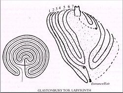
Glastonbury Tor Labyrinth
So if you consider the double snakes twisting up the hill to the spiral castle, which housed a magical cauldron...who is the cauldron/grail?
Wow...
Russell proposed to connect the Tor and its maze with early Welsh poetic allusions to Caer Sidi, the 'turning' or spiral castle. This was a place in pre-Christian mythology which housed a magic cauldron. Caer Sidi was a point of contact with Annwn, a Celtic Otherworld sometimes pictured as underground. Its wonder-working vessel may have been the same as a cauldron of inspiration that belonged to the goddess Ceridwen.
Certainly the legends of Glastonbury link up with these themes. The cauldron, in one guise or another, is a factor in the making of the Grail story, and a very early Welsh poem tells how Arthur and his men went in quest of it. A tale about a visiting saint, Collen, shows that the Tor was regarded as an entrance to Annwn. Russell suggests that the Quest of the Grail has pre-Christian roots in a Celtic ritual which involved threading the Tor maze to the summit and, presumably, attaining a real or symbolic sacred vessel of otherworldly character.
Glastonbury Tor Labyrinth
So if you consider the double snakes twisting up the hill to the spiral castle, which housed a magical cauldron...who is the cauldron/grail?
You can find the Goddess Queen-of-the-Great-Region and her two snakes in the night skies in summertime when you look up to the western edge of the Milky Way you’ll see the star groups of Scorpio and Sagittarius – She is just above them as She has always been and She will be wearing her 7 point crown.
Wow...
a reply to: beansidhe
Hmm... A cosmic avatar!
www.abovetopsecret.com...
A tale about a visiting saint, Collen, shows that the Tor was regarded as an entrance to Annwn. Russell suggests that the Quest of the Grail has pre-Christian roots in a Celtic ritual which involved threading the Tor maze to the summit and, presumably, attaining a real or symbolic sacred vessel of otherworldly character.
Hmm... A cosmic avatar!
www.abovetopsecret.com...
a reply to: Kratos40
Well it's quite an interesting area. There's a few!
You might find this site quite helpful, it has some good information.
ancient wisdom
Well it's quite an interesting area. There's a few!
You might find this site quite helpful, it has some good information.
ancient wisdom
a reply to: beansidhe
I've thought about doing a thread on this a few times and always got side tracked before i finish looking into it more deeply!
I'm gonna have to read this more later, and i'm really just bumping you as i would never had seen this if i hadn't come to the specific forum... it's really annoying how cool stuff can slide off the front page.
Overall though, i lean towards the Earth Zodiac as being a definite possibility... i never finished my own exploration of the ages of the various features that form the shapes (etc) but considering the various massive projects undertaken in antiquity i think it would be simply naive to just discount it out of hand.
Looks like you've collected some very interesting stuff here, i will return!
Incidentally, i first heard of the Earth Zodiac in the Slaine stories... 2000AD was just too cool
ETA: only scanned your OP but you seem to be asking if there were many ancient roads in Britain.... many Roman roads just got laid over the old British tracks made of Hazel or Willow hurdles (like woven fences laid on the ground) - after all you don't get hundreds of war chariots around the country without a decent road or you would be bogged down very quickly indeed, and Caesar notes how fast the Britons seemed to move and organise etc.
Traces of these have been found in various parts of Ireland and Britain... the Sweet Track in somerset is a well known example over marshland.
ETA: i knew i'd read a book on it:
The Sweet Track etc
I've thought about doing a thread on this a few times and always got side tracked before i finish looking into it more deeply!
I'm gonna have to read this more later, and i'm really just bumping you as i would never had seen this if i hadn't come to the specific forum... it's really annoying how cool stuff can slide off the front page.
Overall though, i lean towards the Earth Zodiac as being a definite possibility... i never finished my own exploration of the ages of the various features that form the shapes (etc) but considering the various massive projects undertaken in antiquity i think it would be simply naive to just discount it out of hand.
Looks like you've collected some very interesting stuff here, i will return!
Incidentally, i first heard of the Earth Zodiac in the Slaine stories... 2000AD was just too cool
ETA: only scanned your OP but you seem to be asking if there were many ancient roads in Britain.... many Roman roads just got laid over the old British tracks made of Hazel or Willow hurdles (like woven fences laid on the ground) - after all you don't get hundreds of war chariots around the country without a decent road or you would be bogged down very quickly indeed, and Caesar notes how fast the Britons seemed to move and organise etc.
Traces of these have been found in various parts of Ireland and Britain... the Sweet Track in somerset is a well known example over marshland.
edit on 12-5-2015 by skalla because: addition
ETA: i knew i'd read a book on it:
The Sweet Track etc
edit on 12-5-2015 by skalla because: (no reason given)
a reply to: skalla
Hi Skalla,
I like the earth zodiac theory a lot. It makes sense that people could have thought about geography in relation to the sky - it makes less sense that they wouldn't, when you really start to think about it. I will try and get a thread out on it soon, as promised somewhere else in this thread.
The best thing about you in a thread (although I'm sure you have lots of best bits) is that you always pass on book titles to me! I'm going to associate you with Amazon soon, because I always seem to end up there shortly after reading your posts.
a reply to: beansidhe
They are normally books that i had forgotten i owned, borrowed or read - The Sweet Track was a library borrow maybe 25 years ago. Eek. And i hadn't looked at The Stars and The Stones for maybe several years and i wasn't even sure where it was. I only owned it because a friend picked it up for me by chance in a charity shop iirc..
The earth Zodiac has made me think about chalk figures and some other geoglyph type things.
I'm lazy so i'll copy and paste myself from here
I'm not much of an Astronomer. At all. But it would be interesting to know if one could take a sightline to the particular constellation as it becomes active from the physical feature in question.
It's a bloody fascinating subject but i never gathered much in the way of links on the subject when looking into it last year.
This is pretty much all i squirrelled away.
They are normally books that i had forgotten i owned, borrowed or read - The Sweet Track was a library borrow maybe 25 years ago. Eek. And i hadn't looked at The Stars and The Stones for maybe several years and i wasn't even sure where it was. I only owned it because a friend picked it up for me by chance in a charity shop iirc..
The earth Zodiac has made me think about chalk figures and some other geoglyph type things.
I'm lazy so i'll copy and paste myself from here
I was reading about the White Horse very recently in John North's "Stonehenge - Neolithic Man and the Cosmos". He explains how the general shape of the figure could have changed quite a lot over time (due to it being retouched over thousands of years - it's in a fairly densely populated populated area compared to the urals) he postulates that to draw conclusions from it we should instead look at the specific location of the figure instead.
Interestingly this elk appears from the pics in the links to be on only a slight incline, and similar to the white horse, not situated for best visibility by "locals" - after all, if they wanted to leave a mark that they could all see to it's best, there are many better slopes around to display the figure on for viewing.
North suggests that the incline of the plane that the figure is on is the key factor, and that viewing along the figure from tail to head points at aldebaran (a major star in taurus, and many think the horse was originally a bull). hence many chalk figures being astronomical/astrological markers. nothing too new there, but the perspective of ignoring the dimensions of the figure, and just taking notice of it's setting and the way it points was a somewhat fresh perspective in '96 when published.
so, not for display and viewing at all, but for providing a sightline?
I'm not much of an Astronomer. At all. But it would be interesting to know if one could take a sightline to the particular constellation as it becomes active from the physical feature in question.
It's a bloody fascinating subject but i never gathered much in the way of links on the subject when looking into it last year.
This is pretty much all i squirrelled away.
I just did a little search for more info on pre-Roman roads in Brtain, really looking for hurdle
constructions and found an article/find that was new to me and more than worth sharing:
Don't want to take the thread sideways, but it should be pretty clear now that we had roads before those pesky Romans.
ETA: Source
Archaeologists working at a quarry in Shropshire have found a metalled and cambered road dated to the first century BC – around 100 years before the Roman invasion.
The road was found to include brushwood, a deep clay foundation and cobbles taken from the river Severn.
So far, 400 metres of road has been found, and ruts in it add to the idea that it could have been a trade route. Malim believes that in the iron age, the route could have connected the Wrekin hill, thought to be the "capital" of the Cornovian tribe, to the Ordovices further west. It could also hint that farm produce was being moved from the Midlands into Wales, with perhaps minerals being transported the other way.
Evidence of animal dung and dung beetles has also been found, indicating that before construction of the road it had been used in more ancient times as a livestock droveway.
Don't want to take the thread sideways, but it should be pretty clear now that we had roads before those pesky Romans.
ETA: Source
edit on 12-5-2015 by skalla because: (no
reason given)
a reply to: skalla
That's an excellent article, thanks for bringing it.
That's no country lane for wandering aimlessly about, and your article supposes it was for drovers even before then.
Urrgh, every nerd-sense I have is itching to write this thread about a global zodiac, and I will in a week or two when work calms down.
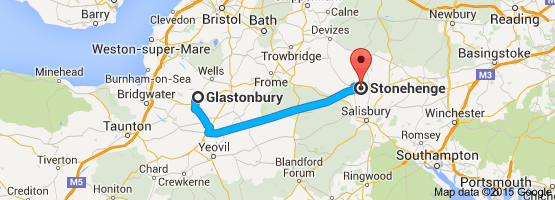
But anyway, thank you for amply demonstrating that roads follow roads ie, there is nothing new under the sun and so... it is plausible that the so-called modern roads which make the Glastonbury zodiac outlines were there in antiquity.
Your White Horse information is fantastic, I had never read that before. I particularly like your 'sightline' theory as it corresponds with another author's belief about Cygnus:
Midnight Science Journal
If you consider the story of the Saltire, what does it say? When the Picts and the Scots were surrounded by the Angles, they fell to their knees to ask God for help...and saw a cross in the sky, at which point they knew God would not leave them and they went on to win the battle.
So an old story remains about a powerful cross in the sky, a cross above Scotland that protects the people, and we remember this on our flag. If you're prone to taking folklore as proof (as I am ) then you have to question this story - why do we still tell it, what was the importance of it, why do we have to remember or more importantly, what is it we are supposed to remember?
I've rambled a bit there, but yes I think it's possible if not likely that these geoglyphs and stone markers tell us more about our skies than they do about our landscapes.
And to return the favour, Stars, Stones and Scholars makes a really compelling case for this argument. And it has a nice picture of the author smoking a fag in an anorak on the back cover, which makes it worth buying for that photo alone.
That's an excellent article, thanks for bringing it.
It may also give an insight into the relationship between the tribes that lived in the region, as the road was almost certainly created to take heavy traffic, suggesting a thriving trade route.
The road, which is 1.5 metres high and six metres wide, was unearthed at Bayston Hill quarry, near Shrewsbury, which fittingly is owned by modern-day roadbuilders Tarmac.
That's no country lane for wandering aimlessly about, and your article supposes it was for drovers even before then.
Urrgh, every nerd-sense I have is itching to write this thread about a global zodiac, and I will in a week or two when work calms down.
But anyway, thank you for amply demonstrating that roads follow roads ie, there is nothing new under the sun and so... it is plausible that the so-called modern roads which make the Glastonbury zodiac outlines were there in antiquity.
Your White Horse information is fantastic, I had never read that before. I particularly like your 'sightline' theory as it corresponds with another author's belief about Cygnus:
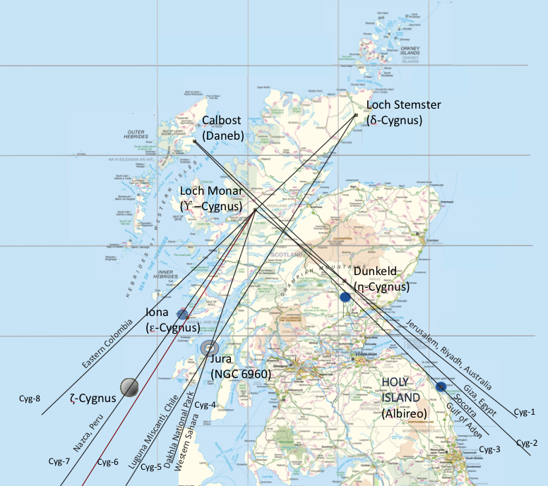
In this paper, a series of possible geoglyph sites have been discovered in Scotland. The sites are of interest because of their location near important religious site, or because they were located within various ancient Kingdoms. The patterns observed at each site are, for the most part, very indistinct, and appear only to be “different” from the surroundings.
However, certain secondary features exist at each sites that appear to tentatively link the sites together. These include the presence of unusual triangular lakes with what appears to be lines running through them at two sites; and at one these sites an unusual horseshoe-shaped stone structure that creates an alignment parallel to the lines running through a nearby circular lake.
The lake and horseshoe structure point “parallel alignment lines” from northeast Scotland to the head of the proposed pattern, at the important 9th century religious center of Holy Island in Northern England. The Holy Island site is anciently connected to it’s parent Abbey at Iona in Scotland (1), where an indistinct “X” pattern can be found.
The intrigue surrounding the sites of Holy Island (2), Dunkeld (3) and Iona is that, together, the sites appear to create the shape of the head and wing stars of the constellation Cygnus, the Swan. The Swan is often associated with British royalty, and the shape of the cross pattern created over Scotland appears similar to the pattern of the Scotland Flag, the St Andrews Cross.
Strangely, the town of St Andrews (which appears by virtue of its name to be the town with the strongest links to the St Andrews Flag) occurs at the same latitude as the abbey at Iona. In addition, Holy Island, to which the abbey of Iona is linked, is at the same longitude as Stonehenge in England.
Midnight Science Journal
If you consider the story of the Saltire, what does it say? When the Picts and the Scots were surrounded by the Angles, they fell to their knees to ask God for help...and saw a cross in the sky, at which point they knew God would not leave them and they went on to win the battle.
So an old story remains about a powerful cross in the sky, a cross above Scotland that protects the people, and we remember this on our flag. If you're prone to taking folklore as proof (as I am ) then you have to question this story - why do we still tell it, what was the importance of it, why do we have to remember or more importantly, what is it we are supposed to remember?
I've rambled a bit there, but yes I think it's possible if not likely that these geoglyphs and stone markers tell us more about our skies than they do about our landscapes.
And to return the favour, Stars, Stones and Scholars makes a really compelling case for this argument. And it has a nice picture of the author smoking a fag in an anorak on the back cover, which makes it worth buying for that photo alone.
edit on 12-5-2015 by beansidhe because: sp
a reply to: beansidhe
At six metres wide it's a beast of an ancient road, no question... wikipedia even states that The Sweet Track in Somerset is possibly the world's oldest intentional road at about 3800 bc which i'm a bit surprised by but then it's all down to what we find and what we don't.
Fascinating stuff about Loch Stemster too which is all new to me so i've got a fair bit of stuff to look into there.
The Cygnus idea is pretty plausible at first glance, and as to folklore and myth, well, it's often a way to codify and orally transmit knowledge and history so why not?
Many thanks for the book recommendation too, it looks a goody.. but i'm seriously flagging here and will have to save all this for another day!
Very cool thread
a reply to: skalla
Me too, I'm gubbed.
It all ties in so neatly with the Pictish Stones, which are astronomical in nature, but such a huge topic that it makes my head spin, especially at this time of night.
But I'll leave you with my most favourite article which sums it all up very well:
Good night!
Under A Celtic Sky
new topics
-
Supreme Court Oral Arguments 4.25.2024 - Are PRESIDENTS IMMUNE From Later Being Prosecuted.
Above Politics: 59 minutes ago -
Krystalnacht on today's most elite Universities?
Social Issues and Civil Unrest: 1 hours ago -
Chris Christie Wishes Death Upon Trump and Ramaswamy
Politicians & People: 1 hours ago -
University of Texas Instantly Shuts Down Anti Israel Protests
Education and Media: 3 hours ago -
Any one suspicious of fever promotions events, major investor Goldman Sachs card only.
The Gray Area: 5 hours ago -
God's Righteousness is Greater than Our Wrath
Religion, Faith, And Theology: 10 hours ago
top topics
-
VP's Secret Service agent brawls with other agents at Andrews
Mainstream News: 14 hours ago, 11 flags -
Nearly 70% Of Americans Want Talks To End War In Ukraine
Political Issues: 15 hours ago, 6 flags -
Sunak spinning the sickness figures
Other Current Events: 15 hours ago, 5 flags -
Electrical tricks for saving money
Education and Media: 13 hours ago, 4 flags -
Late Night with the Devil - a really good unusual modern horror film.
Movies: 17 hours ago, 3 flags -
Krystalnacht on today's most elite Universities?
Social Issues and Civil Unrest: 1 hours ago, 3 flags -
Supreme Court Oral Arguments 4.25.2024 - Are PRESIDENTS IMMUNE From Later Being Prosecuted.
Above Politics: 59 minutes ago, 3 flags -
Any one suspicious of fever promotions events, major investor Goldman Sachs card only.
The Gray Area: 5 hours ago, 2 flags -
University of Texas Instantly Shuts Down Anti Israel Protests
Education and Media: 3 hours ago, 2 flags -
Chris Christie Wishes Death Upon Trump and Ramaswamy
Politicians & People: 1 hours ago, 1 flags
active topics
-
University of Texas Instantly Shuts Down Anti Israel Protests
Education and Media • 75 • : CriticalStinker -
Nearly 70% Of Americans Want Talks To End War In Ukraine
Political Issues • 72 • : andy06shake -
Chris Christie Wishes Death Upon Trump and Ramaswamy
Politicians & People • 6 • : mysterioustranger -
"We're All Hamas" Heard at Columbia University Protests
Social Issues and Civil Unrest • 282 • : 5thHead -
British TV Presenter Refuses To Use Guest's Preferred Pronouns
Education and Media • 152 • : PorkChop96 -
Candidate TRUMP Now Has Crazy Judge JUAN MERCHAN After Him - The Stormy Daniels Hush-Money Case.
Political Conspiracies • 745 • : network dude -
President BIDEN Vows to Make Americans Pay More Federal Taxes in 2025 - Political Suicide.
2024 Elections • 141 • : Euronymous2625 -
-@TH3WH17ERABB17- -Q- ---TIME TO SHOW THE WORLD--- -Part- --44--
Dissecting Disinformation • 664 • : 777Vader -
Hate makes for strange bedfellows
US Political Madness • 46 • : network dude -
The Reality of the Laser
Military Projects • 48 • : 5thHead