It looks like you're using an Ad Blocker.
Please white-list or disable AboveTopSecret.com in your ad-blocking tool.
Thank you.
Some features of ATS will be disabled while you continue to use an ad-blocker.

Silbury Hill was 'an ancient lighthouse by the sea', author claims
page: 115
share:
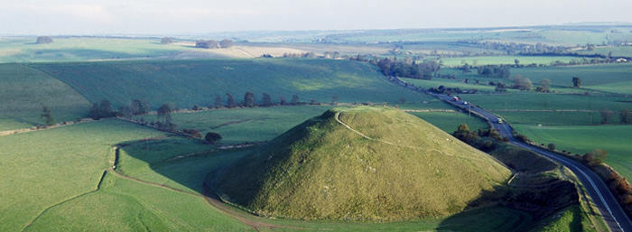
It has been an enigma for centuries, but now an author and mapmaker believes he has come up with the reason Silbury Hill in Wiltshire – Europe’s largest manmade Neolithic structure – exists.
It was not some kind of elaborate grave, nor a ceremonial hilltop to bring our ancestors closer to the gods. In fact, according to Robert John Langdon, Silbury Hill was an ancient lighthouse built to help ships, sailing on the post-glacial waterways of what is now very much the dry land of southern England, find their way to the nearby holy place of Avebury.
Langdon’s rather unconventional hypotheses of Wiltshire’s ancient sites have hit the headlines before. He claims that archaeologists and historians looking to come up with theories about Stonehenge and Avebury miss one vital point – the sea level was much higher thousands of years ago as the ice caps melted from the last Ice Age.
In a book four years ago, he claimed southern Britain was a series of islands linked by waterways, channels and huge swollen rivers, and that Stonehenge was located where it was because it was close to what was effectively the coast.
I'm not sure if I buy what he's selling here but....
What I'd like to draw the readers attention to is the fact that the author is correct in that "ancient man" lived through a period of change, they didn't have the written word to carry their history but had word of mouth and as is often the case facts tend to get skewed. This is not to say the author isn't correct in his hypothesis, Could be true, it wouldn't surprise me considering we in the modern world can't seem to keep basic facts straight on current events of just a couple of months ago. not to mention a few years back.
The Great Flood myths and legends of old from all over the Ancient world in my opinion were all to varying degrees based on ancient sea level coastal changes during the pre and post Glacial period. Make no mistake while considering his theory. Man lived during these periods and massive changes did in fact occur...
This is an extract from the book 'The Stonehenge Enigma' that explains the principle theory about global flooding after the last Ice Age.
The hypothesis suggests that after the great flood that occurred after the last Ice Age the 'Post Glacial Flooding' caused mankind to adapt to his new surroundings and they built their settlements on the shorelines of this flooded world.
Thank you for reading.
Thoughts?
How old is the hill? If it is under 10,000 years ago wouldnt that put it into the most recent ice age, meaning that the sea level was vastly lower
than what it is today?
And also did they have a large enough shipping infrastructure before 10k years ago to have to construct a lighthouse? I thought it was still more of small tribal communities.
And also did they have a large enough shipping infrastructure before 10k years ago to have to construct a lighthouse? I thought it was still more of small tribal communities.
a reply to: Snarl
Good question, The idea and construction of a "Light house" type structure had to start someplace and some point in history. If his theory is true, I'm sure it wasn't the first nor the only type of structure to be used as such. I would have written man made "Hill Beacon" instead of light house though.
Good question, The idea and construction of a "Light house" type structure had to start someplace and some point in history. If his theory is true, I'm sure it wasn't the first nor the only type of structure to be used as such. I would have written man made "Hill Beacon" instead of light house though.
It's been well suggested that the ancient depression around the hill, when filled with water would have made the profile of a seated woman, the hill
forming the "cosmic egg"/pregnant belly.
It's more than likely that as a remarkable and intentional landmark too, it would indeed have had a beacon on top. Especially when one considers the visual impact of the Chalk structure.
I feel that the author is way over estimating the amount of waterways in that area though. And inventing it's proximity to the sea. My impression of the region in antiquity is more of a swamp than a network of rivers/channels etc.
edit on 8-3-2015 by skalla because: grandma
originally posted by: TheLotLizard
And also did they have a large enough shipping infrastructure before 10k years ago to have to construct a lighthouse? I thought it was still more of small tribal communities.
I doubt there were any sort of organized shipping but rather, small groups of traders taking advantage of small water ways. If true, these ancient coastal levels and waterways would have seemed to them as do ours now seem fairly stable. We build massive cities right on the modern Coasts. Shorelines have and will continue to change. Good Luck Los Angeles, London, Hong Kong etc still existing untouched by that inevitable change in say 500 or 1,000 or more never mind 6 to 8 thousand years from now.
Been there in the winter and we wanted to sledge down it but it had signs everywhere telling people not to climb it.
Dunno If his claims are true, they sure could be seeing no one knows what it was made for.
Legend says it is the ancient burial site for King Zel and his horse.
Cool find slayer.
More info here.
www.english-heritage.org.uk...
Just attempting to find out about King zel...can't find nowt
Dunno If his claims are true, they sure could be seeing no one knows what it was made for.
Legend says it is the ancient burial site for King Zel and his horse.
Cool find slayer.
More info here.
www.english-heritage.org.uk...
Just attempting to find out about King zel...can't find nowt
edit on 8-3-2015 by boymonkey74 because: (no reason given)
originally posted by: skalla
It's been well suggested that the ancient depression around the hill, when filled with water would have made the profile of a seated woman, the hill forming the "cosmic egg"/pregnant belly.
It's more than likely that as a remarkable and intentional landmark too, it would indeed have had a beacon on top. Especially when one considers the visual impact of the Chalk structure.
I feel that the author is way over estimating the amount of waterways in that area though. And inventing it's proximity to the sea. My impression of the region in antiquity is more of a swamp than a network of rivers/channels etc.
ETA: the author has a very interesting site that i feel i may spend quite some time reading... i wouldn't be surprised to find some remarkable misapprehensions there too based on my first glance.
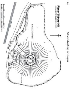
Looking into it more it appears the mound was built in three distinct phases.
www.pegasusarchive.org...
www.pegasusarchive.org...
I think that the author is blagging up his own book. Silbury hill is miles inland and is surrounded by hills and higher ground. A lighthouse makes no
sense. As the Avebury complex is nearby, it's more likely that it's a part of that.
a reply to: AngryCymraeg
Here's an interesting read...
Submerged Prehistoric Archaeology and Landscapes of the Continental Shelf
Here's an interesting read...
Submerged Prehistoric Archaeology and Landscapes of the Continental Shelf
For most of human history on this planet—about 90 per cent of the time—sea levels have been substantially lower than at present, exposing large tracts of territory for human settlement. Europe alone would have had a land area increased by 40 per cent at the maximum sea level regression (Figure 1). Although this has been recognised for many decades, archaeologists have resisted embracing its full implications, barely accepting that most evidence of Palaeolithic marine exploitation must by definition be invisible, believing that nothing has survived or can be found on the seabed, and preferring instead to emphasise the opportunities afforded by lower sea level for improved terrestrial dispersal across land bridges and narrowed sea channels.
In the past decade, opinions have begun to change in response to a number of factors: evidence that marine exploitation and seafaring have a much deeper history in the Pleistocene than previously recognised; the steady accumulation of new underwater Stone Age sites and materials, amounting now to over 3000 in Europe, and often with unusual and spectacular conditions of preservation (Figure 2); availability of new technologies and research strategies for underwater exploration; and the growth of targeted underwater research (Erlandson 2001; Bailey & Milner 2002; Anderson et al. 2010; Benjamin et al. 2011).
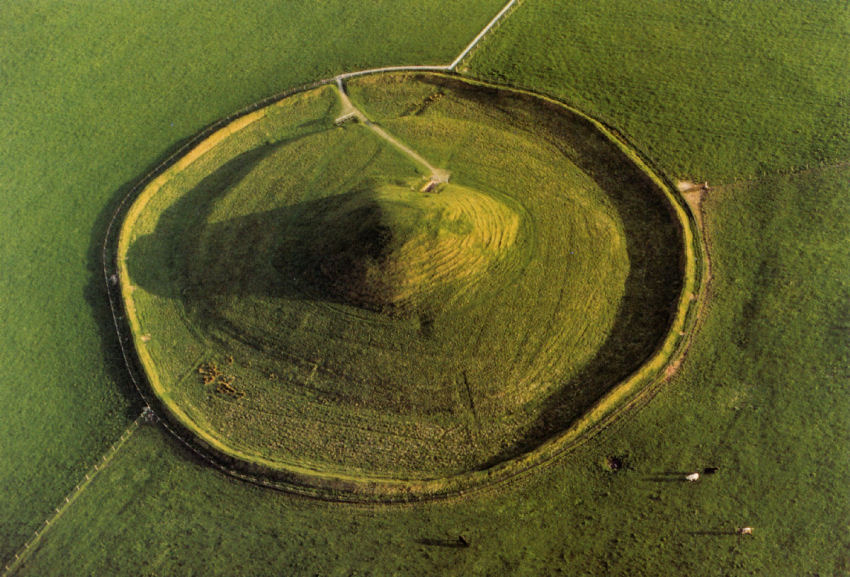
Here is a birds eye view of the site and its surroundings.
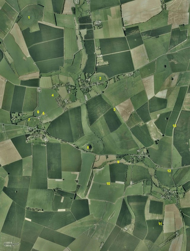
1. Windmill Hill.
2. Avebury.
3. West Kennet Avenue.
4. Beckhampton Avenue (now invisible).
5. South Street Long Barrow (now invisible).
6. The Longstones.
7. Beckhampton Long Barrow.
8. Silbury Hill.
9. The Enclosures.
10. West Kennet Long Barrow.
11. East Kennet Long Barrow.
12. The Sanctuary.
13. The Ridgeway.
www.pegasusarchive.org...
Pretty isn't it.
edit on 8-3-2015 by boymonkey74 because: (no reason given)
a reply to: SLAYER69
It has been said that since the ice melted in Scotland the south of England is slowly sinking and Scotland is rising ,
if that is the case then surely the south of England would still be a collection of small islands .
so how does he explain that ?.
It has been said that since the ice melted in Scotland the south of England is slowly sinking and Scotland is rising ,
if that is the case then surely the south of England would still be a collection of small islands .
so how does he explain that ?.
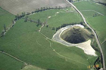
For those who have not read before about what i mentioned earlier, here is a phot of the "moat" filled nowadays, though it's upside down as far as the
suggested profile of a mother is concerned:
and diagrams...
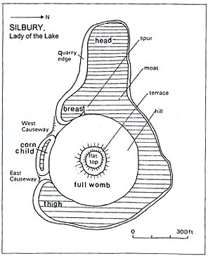
I don't remember whether any excavation has proved the age or shape of the moat in antiquity though, but iirc it has always been described as contemporary to one of the hill's phases.
Such a great place to visit too, you can just pull up at the side of the road for both Silbury Hill and West Kennet Long-Barrow and walk around all you please after a nice picnic amongst the Stones at Avebury. Totally taking my boy this summer. It's sink or swim for the lad as i know i'm going blow his mind with factoids and what if's
and diagrams...
I don't remember whether any excavation has proved the age or shape of the moat in antiquity though, but iirc it has always been described as contemporary to one of the hill's phases.
Such a great place to visit too, you can just pull up at the side of the road for both Silbury Hill and West Kennet Long-Barrow and walk around all you please after a nice picnic amongst the Stones at Avebury. Totally taking my boy this summer. It's sink or swim for the lad as i know i'm going blow his mind with factoids and what if's
edit on 8-3-2015 by skalla because: "don't"
He could be onto something you know.I assume He is not taking the fact that pole shifts a have occurred in the past into account? And the relocation
of the poles would raise the sea level over a period of many years as they melt and then re freeze also over a period of many years,subsequently
lowering the levels yet again.
I am skeptical of the Ice age theory,as yes there was land frozen..but this was because certain areas were actually nearer the poles and when they geographically relocated they melted,giving rise to new pastures and from this we have been fed the ice age BS to cover up the reality of cyclical pole shifts.
I am skeptical of the Ice age theory,as yes there was land frozen..but this was because certain areas were actually nearer the poles and when they geographically relocated they melted,giving rise to new pastures and from this we have been fed the ice age BS to cover up the reality of cyclical pole shifts.
a reply to: SLAYER69
interesting area, stone circles, long barrows, site of many crop circles.
silbury hill has been tunneled into a few times over the years.
a lighthouse? no
beacon? maybe
it does resemble pyramidal structures from around the world though.
I have stood on top and it is rather large!
interesting area, stone circles, long barrows, site of many crop circles.
silbury hill has been tunneled into a few times over the years.
a lighthouse? no
beacon? maybe
it does resemble pyramidal structures from around the world though.
I have stood on top and it is rather large!
Wouldn't this idea require that the water the author claims formerly flooded that part of England would have to have been locked back up in ice since
that time?
Sorry. Either we're in an ice age right now, or we're not.
The polar caps are far smaller today than they were when that hill was erected. Why isn't the hill on the shore now?
Harte
Sorry. Either we're in an ice age right now, or we're not.
The polar caps are far smaller today than they were when that hill was erected. Why isn't the hill on the shore now?
Harte
a reply to: skalla
I think he's over-estimating too, because Mae's Howe (Orkney) was also thought to have a moat:
Just as we are born from (amniotic) waters, the waters separate us in our world from the pre-life/death of the Otherworld. This explanation seems to fit better, as it would match up with other chambered cairns from the Neolithic. They can't all have had lighthouses on them, I wouldn't have thought.
Great thread, Slayer although weren't the Etruscans credited with lighthouses?
new topics
-
God's Righteousness is Greater than Our Wrath
Religion, Faith, And Theology: 26 minutes ago -
Electrical tricks for saving money
Education and Media: 3 hours ago -
VP's Secret Service agent brawls with other agents at Andrews
Mainstream News: 4 hours ago -
Sunak spinning the sickness figures
Other Current Events: 5 hours ago -
Nearly 70% Of Americans Want Talks To End War In Ukraine
Political Issues: 5 hours ago -
Late Night with the Devil - a really good unusual modern horror film.
Movies: 7 hours ago -
Cats Used as Live Bait to Train Ferocious Pitbulls in Illegal NYC Dogfighting
Social Issues and Civil Unrest: 8 hours ago -
The Good News According to Jesus - Episode 1
Religion, Faith, And Theology: 10 hours ago
top topics
-
Florida man's trip overseas ends in shock over $143,000 T-Mobile phone bill
Social Issues and Civil Unrest: 15 hours ago, 8 flags -
Cats Used as Live Bait to Train Ferocious Pitbulls in Illegal NYC Dogfighting
Social Issues and Civil Unrest: 8 hours ago, 8 flags -
VP's Secret Service agent brawls with other agents at Andrews
Mainstream News: 4 hours ago, 8 flags -
Bobiverse
Fantasy & Science Fiction: 15 hours ago, 3 flags -
HORRIBLE !! Russian Soldier Drinking Own Urine To Survive In Battle
World War Three: 12 hours ago, 3 flags -
Electrical tricks for saving money
Education and Media: 3 hours ago, 3 flags -
Nearly 70% Of Americans Want Talks To End War In Ukraine
Political Issues: 5 hours ago, 3 flags -
Sunak spinning the sickness figures
Other Current Events: 5 hours ago, 3 flags -
Late Night with the Devil - a really good unusual modern horror film.
Movies: 7 hours ago, 2 flags -
The Good News According to Jesus - Episode 1
Religion, Faith, And Theology: 10 hours ago, 1 flags
active topics
-
New whistleblower Jason Sands speaks on Twitter Spaces last night.
Aliens and UFOs • 53 • : pianopraze -
Sunak spinning the sickness figures
Other Current Events • 5 • : glen200376 -
SETI chief says US has no evidence for alien technology. 'And we never have'
Aliens and UFOs • 44 • : MikeDeGrasseTyson -
HORRIBLE !! Russian Soldier Drinking Own Urine To Survive In Battle
World War Three • 31 • : budzprime69 -
How ageing is" immune deficiency"
Medical Issues & Conspiracies • 33 • : rickymouse -
VP's Secret Service agent brawls with other agents at Andrews
Mainstream News • 32 • : ThatSmellsStrange -
The Reality of the Laser
Military Projects • 46 • : Zaphod58 -
God's Righteousness is Greater than Our Wrath
Religion, Faith, And Theology • 0 • : randomuser2034 -
President BIDEN Vows to Make Americans Pay More Federal Taxes in 2025 - Political Suicide.
2024 Elections • 136 • : ImagoDei -
Electrical tricks for saving money
Education and Media • 3 • : Mike72
15