It looks like you're using an Ad Blocker.
Please white-list or disable AboveTopSecret.com in your ad-blocking tool.
Thank you.
Some features of ATS will be disabled while you continue to use an ad-blocker.

Doggerland Revealing a Once Continental Britain
page: 114
share:
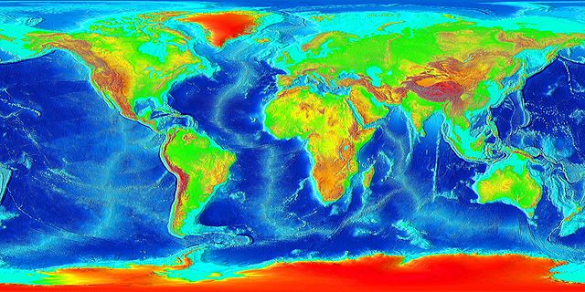
Image from: upload.wikimedia.org...
The pic above shows the continental shelf around the world (in light blue along the continents). Since the end of the Last Ice Age, the world wide sea levels have risen somewhere between 120 to 150 meters, meaning that most of what is referred to these days as the Continental Shelf, was dry land. Part of this extended continent, we today call Doggerland, or as we say in Norwegian, Nordsjøfastlandet or 'North Sea Land'.
You can see a pic showing Doggerland as one artist has expressed it here:
==> www.greenfudge.org...
shown on the page ==> www.greenfudge.org...
Here's another picture:
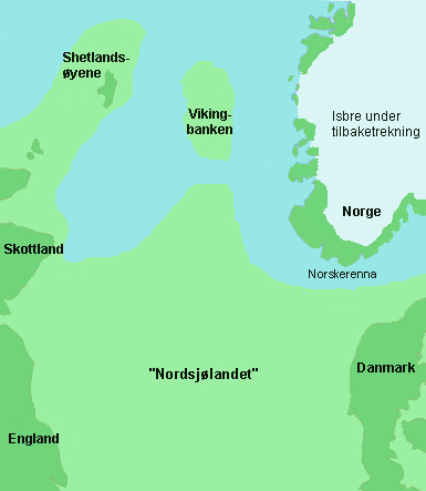
Image from: upload.wikimedia.org...
Caption: Nordsjølandet (Doggerland) as it may have looked 11500 years ago or c. 9500 BC
As the sea level rose over a period of several thousand years, series of devastating tsunamis and floods occurred giving life to myths like the Flood of Noah, probably as the Mediterranean broke through the Bosporos Strait creating what we now know as the Black Sea-- and possibly inspired Plato to write about his Atlantis. There is a real side to these myths. And one of these very real 'Atlantises' was the area we now call Doggerland. It connected the British Isles with the Continent, in effect extending the dry land of Continental Europe way into what is now ocean.
If all the inland glaciers (Antarctica and Greenland etc) world wide sea levels would rise an additional 70-100 meters covering nearly all of today's highly populated coastal areas under leagues of water.
edit on 19-1-2015 by Utnapisjtim because: Pic + rephrasing + Caption + moved misplaced
§ + light blue + structure
a reply to: Utnapisjtim
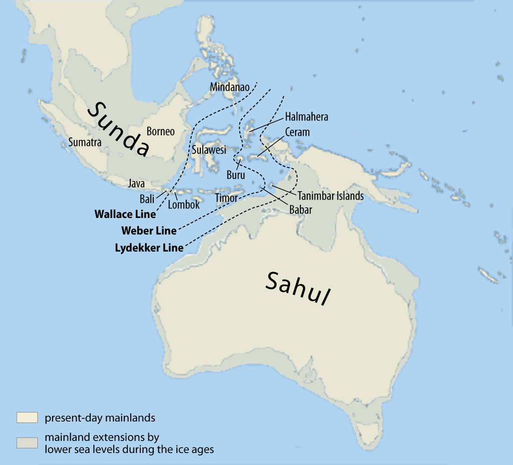
Similarly, there were the ancient landmasses of Sunda (Sundaland) and Sahul:
Lots of stuff submerged after the end of the last ice age.
Similarly, there were the ancient landmasses of Sunda (Sundaland) and Sahul:
Lots of stuff submerged after the end of the last ice age.
edit on 2015-1-19 by theantediluvian because: (no reason given)
a reply to: theantediluvian
Indeed. Thanks for adding the pic, and yes, this was a world wide phenomenon. Like I said in the OP, most of what is called the continental shelf today was dry land before the melting water from the ice-age glaciers started filling the oceans about 20 000 years ago until the melting stopped and the sea-level stabilised itself where it is now around 6000 BC. Over a period of roughly 12 000 years, the general sea level rose with roughly 120-150 meters.
Indeed. Thanks for adding the pic, and yes, this was a world wide phenomenon. Like I said in the OP, most of what is called the continental shelf today was dry land before the melting water from the ice-age glaciers started filling the oceans about 20 000 years ago until the melting stopped and the sea-level stabilised itself where it is now around 6000 BC. Over a period of roughly 12 000 years, the general sea level rose with roughly 120-150 meters.
It continues today; London and the Southern half of the UK are slowly sinking downwards by a few centimeters each century, while Scotland is actually
rising upwards by the same amount.
Doggerland information comes out painfully slow....
It is very fascinating. The frustration of knowing that amazing finds exist out under the water, and that we can't really get to them, can drive you insane.
Where does the name "Doggerland" derive from?
It is very fascinating. The frustration of knowing that amazing finds exist out under the water, and that we can't really get to them, can drive you insane.
Where does the name "Doggerland" derive from?
originally posted by: bigfatfurrytexan
Where does the name "Doggerland" derive from?
Dogger Bank
The name comes from dogger, an old Dutch word for fishing boat, especially for catching cod
Not to be confused with favorite British past time Dogging
edit on 19-1-2015 by Dabrazzo
because: (no reason given)
a reply to: bigfatfurrytexan
As far as I know a Dogger is a kind of Dutch fishing boat. Doggerland is a modern name, probably derived from the shallow sand bank called Dogger Bank, which is named after said boat type.
ETA: a reply to: Dabrazzo
Yes, that
As far as I know a Dogger is a kind of Dutch fishing boat. Doggerland is a modern name, probably derived from the shallow sand bank called Dogger Bank, which is named after said boat type.
ETA: a reply to: Dabrazzo
Yes, that
edit on 19-1-2015 by Utnapisjtim because: eta
originally posted by: SlapMonkey
a reply to: stormcell
Wouldn't land rising and falling be more of a geological process than ice melting, assuming the measurements are relative to a stable measurement standard (like the sea level at one point in time)?
with respect to land rising and falling/ sea levels during iceages and meltofffs.
when the land is covered in ice it is depressed by the immense weight of the ice. As the ice melts the land rises, this has given some areas the apperance of much larger sea level rises than actually happened.
Much of the continental masses in the northern hemisphere are still rebounding.
a reply to: Echtelion
Nah, you're correct, I was thinking about what we would call the British Isles and Ireland and the Orkeys etc today, long before the Berit in Britannia had been sworn. What would be the correct name or term for the islands currently occupied by GB and Ireland? Geologically speaking perhaps?
Nah, you're correct, I was thinking about what we would call the British Isles and Ireland and the Orkeys etc today, long before the Berit in Britannia had been sworn. What would be the correct name or term for the islands currently occupied by GB and Ireland? Geologically speaking perhaps?
edit on 20-1-2015 by Utnapisjtim because: .......
a reply to: punkinworks10
Yeah, I was thinking more about the part of the land sinking, though (without the weight of gigatons of ice to press it down. I guess you're implying that maybe it's acting like a teeter-totter, and when one side rises, the other side falls out of necessity?
Ha...nevermind. I looked into Post-Glacial Rebound, and read this on Wikipedia (I know...I know...):
I guess that answers the teeter-totter question!
Thanks for the response. I always like comments that make me do a little more research.
Yeah, I was thinking more about the part of the land sinking, though (without the weight of gigatons of ice to press it down. I guess you're implying that maybe it's acting like a teeter-totter, and when one side rises, the other side falls out of necessity?
Ha...nevermind. I looked into Post-Glacial Rebound, and read this on Wikipedia (I know...I know...):
In Great Britain, glaciation affected Scotland but not southern England, and the post-glacial rebound of northern Great Britain (up to 10 cm per century) is causing a corresponding downward movement of the southern half of the island (up to 5 cm per century). This will eventually lead to an increased risk of floods in southern England and south-western Ireland.
I guess that answers the teeter-totter question!
Thanks for the response. I always like comments that make me do a little more research.
new topics
-
Electrical tricks for saving money
Education and Media: 29 minutes ago -
VP's Secret Service agent brawls with other agents at Andrews
Mainstream News: 1 hours ago -
Sunak spinning the sickness figures
Other Current Events: 2 hours ago -
Nearly 70% Of Americans Want Talks To End War In Ukraine
Political Issues: 2 hours ago -
Late Night with the Devil - a really good unusual modern horror film.
Movies: 4 hours ago -
Cats Used as Live Bait to Train Ferocious Pitbulls in Illegal NYC Dogfighting
Social Issues and Civil Unrest: 5 hours ago -
The Good News According to Jesus - Episode 1
Religion, Faith, And Theology: 7 hours ago -
HORRIBLE !! Russian Soldier Drinking Own Urine To Survive In Battle
World War Three: 9 hours ago
top topics
-
SETI chief says US has no evidence for alien technology. 'And we never have'
Aliens and UFOs: 16 hours ago, 8 flags -
Cats Used as Live Bait to Train Ferocious Pitbulls in Illegal NYC Dogfighting
Social Issues and Civil Unrest: 5 hours ago, 8 flags -
Florida man's trip overseas ends in shock over $143,000 T-Mobile phone bill
Social Issues and Civil Unrest: 12 hours ago, 8 flags -
VP's Secret Service agent brawls with other agents at Andrews
Mainstream News: 1 hours ago, 6 flags -
Former Labour minister Frank Field dies aged 81
People: 15 hours ago, 4 flags -
Bobiverse
Fantasy & Science Fiction: 12 hours ago, 3 flags -
HORRIBLE !! Russian Soldier Drinking Own Urine To Survive In Battle
World War Three: 9 hours ago, 3 flags -
Nearly 70% Of Americans Want Talks To End War In Ukraine
Political Issues: 2 hours ago, 3 flags -
Sunak spinning the sickness figures
Other Current Events: 2 hours ago, 3 flags -
Late Night with the Devil - a really good unusual modern horror film.
Movies: 4 hours ago, 2 flags
active topics
-
VP's Secret Service agent brawls with other agents at Andrews
Mainstream News • 16 • : matafuchs -
Should Biden Replace Harris With AOC On the 2024 Democrat Ticket?
2024 Elections • 49 • : Therealbeverage -
WF Killer Patents & Secret Science Vol. 1 | Free Energy & Anti-Gravity Cover-Ups
General Conspiracies • 32 • : Arbitrageur -
Is there a hole at the North Pole?
ATS Skunk Works • 38 • : Therealbeverage -
Cats Used as Live Bait to Train Ferocious Pitbulls in Illegal NYC Dogfighting
Social Issues and Civil Unrest • 11 • : charlyv -
SETI chief says US has no evidence for alien technology. 'And we never have'
Aliens and UFOs • 41 • : TheMisguidedAngel -
Naked Eye Supernova Erupting in the T Coronae Borealis
Space Exploration • 13 • : Therealbeverage -
The Real Reason Behind the Sean Combes Exposure
Political Conspiracies • 45 • : ThatSmellsStrange -
Electrical tricks for saving money
Education and Media • 0 • : annonentity -
Late Night with the Devil - a really good unusual modern horror film.
Movies • 4 • : DBCowboy
14