It looks like you're using an Ad Blocker.
Please white-list or disable AboveTopSecret.com in your ad-blocking tool.
Thank you.
Some features of ATS will be disabled while you continue to use an ad-blocker.

Quake Watch 2015
page: 7share:
early this morning NZDT
Public ID 2015p104433
Universal Time February 8 2015, 15:22:10
NZ Daylight Time Mon, Feb 9 2015, 4:22:10 am
Depth 293 km
Magnitude 5.4
Location East Cape Ridge Off NI N.Z.
Latitude, Longitude -35.10, -179.97
Agency WEL(GNS_Primary)
www.geonet.org.nz...
USelessGS are calling it 4.9mb and South of the Kermadec Is ('spos it is, but then so is most of New Zealand)
This is a good size one for Baja.
M4.9 - 88km ESE of Maneadero, B.C., Mexico
Magnitude: 4.9 mw
Locationuncertainty: 31.526°N 115.665°W± 0.9 km
Depthuncertainty: 1.9 km± 5.2
Origin Time: 2015-02-09 01:45:02.840 UTC
Number of Stations: 6
Number of Phases: 7
Minimum Distance: 56.66 km (0.51°)
Travel Time Residual: 0.13 sec
Azimuthal Gap: 133°
FE Region: –
Review Status: MANUAL
Source
M4.0
(Upgraded to 4.2)
12km WSW of Volcano, Hawaii
Event Time
2015-02-09 18:16:15 (UTC)
Location
19.374°N 155.341°W
Depth
12.6 km
Nearby Cities
12km (7mi) WSW of Volcano, Hawaii
45km (28mi) WSW of Hawaiian Paradise Park, Hawaii
47km (29mi) SSW of Hilo, Hawaii
74km (46mi) ESE of Kailua-Kona, Hawaii
338km (210mi) SE of Honolulu, Hawaii
earthquake.usgs.gov...
This side of Hawaii has been bugging me for over a year now.
edit on 9-2-2015 by Darkblade71 because: (no reason given)
M6.7
93km W of El Aguilar, Argentina
Event Time
2015-02-11 18:57:18 (UTC)
Nearby Cities
93km (58mi) W of El Aguilar, Argentina
128km (80mi) W of Humahuaca, Argentina
153km (95mi) SW of La Quiaca, Argentina
154km (96mi) SW of Villazon, Bolivia
750km (466mi) SSE of La Paz, Bolivia
earthquake.usgs.gov...
93km W of El Aguilar, Argentina
Event Time
2015-02-11 18:57:18 (UTC)
Nearby Cities
93km (58mi) W of El Aguilar, Argentina
128km (80mi) W of Humahuaca, Argentina
153km (95mi) SW of La Quiaca, Argentina
154km (96mi) SW of Villazon, Bolivia
750km (466mi) SSE of La Paz, Bolivia
earthquake.usgs.gov...
I feel a M6 for NZ coming on.
data shows a pre-M5 low of energy released of 8TTNT the last 24 hours, very low.
data shows a pre-M5 low of energy released of 8TTNT the last 24 hours, very low.
2015-02-13 18:59:14, 6.7 , 52.75°N , 31.97°W, 10, A Northern Mid Atlantic Ridge
2015-02-13 18:58:06, 6.1 , 52.47°N , 31.70°W, 10, A Northern Mid Atlantic Ridge
geofon.gfz-potsdam.de...
between Newfoundland and Ireland
eastern end of Charlie-Gibbs Fracture Zone
already changed in the time it took me to paste and edit the above!
2015-02-13 18:59:13 2015-02-13 18:59:13 6.7 52.70°N 31.93°W 10 M Northern Mid Atlantic Ridge
2015-02-13 18:58:06, 4.9, 52.55°N, 31.63°W, 10, M, Northern Mid Atlantic Ridge
2015-02-13 18:48:18, 5.4, 52.73°N, 31.86°W, 10, M, Northern Mid Atlantic Ridge
2015-02-13 18:58:06, 6.1 , 52.47°N , 31.70°W, 10, A Northern Mid Atlantic Ridge
geofon.gfz-potsdam.de...
between Newfoundland and Ireland
eastern end of Charlie-Gibbs Fracture Zone
edit on 02u434315 by muzzy because: bit of colour
already changed in the time it took me to paste and edit the above!
2015-02-13 18:59:13 2015-02-13 18:59:13 6.7 52.70°N 31.93°W 10 M Northern Mid Atlantic Ridge
2015-02-13 18:58:06, 4.9, 52.55°N, 31.63°W, 10, M, Northern Mid Atlantic Ridge
2015-02-13 18:48:18, 5.4, 52.73°N, 31.86°W, 10, M, Northern Mid Atlantic Ridge
edit on 02u434315 by muzzy because: double paste
No word on the Possible Tsunami on the east coast, 6.8 off the east coast?
sorry for the informal structure, but my boss just informed me of this and I'm a bit surprised and freaked out.
EDIT: I cant find anything on it sorry, I was looking for a link. I did see it on her phone though....hmm, sorry if I was wrong and posted too soon everybody...
sorry for the informal structure, but my boss just informed me of this and I'm a bit surprised and freaked out.
EDIT: I cant find anything on it sorry, I was looking for a link. I did see it on her phone though....hmm, sorry if I was wrong and posted too soon everybody...
edit on 13-2-2015 by GoShredAK because: ??
a reply to: GoShredAK
doubt it, needs to be over M7.5 to cause anything significant from that distance
US say 6.8Mi, still building the page by the look of it, on conversion to Mw likely will come down
earthquake.usgs.gov...
doubt it, needs to be over M7.5 to cause anything significant from that distance
US say 6.8Mi, still building the page by the look of it, on conversion to Mw likely will come down
earthquake.usgs.gov...
edit on 02000000434315 by muzzy because: (no reason given)
6.9
Northern Mid-Atlantic Ridge
2015-02-13 12:59:11 UTC-06:0010.0 km
4.9
Northern Mid-Atlantic Ridge
2015-02-13 12:58:06 UTC-06:0010.0 km
5.3
Northern Mid-Atlantic Ridge
2015-02-13 12:48:16 UTC-06:0010.0 km
yikes
Northern Mid-Atlantic Ridge
2015-02-13 12:59:11 UTC-06:0010.0 km
4.9
Northern Mid-Atlantic Ridge
2015-02-13 12:58:06 UTC-06:0010.0 km
5.3
Northern Mid-Atlantic Ridge
2015-02-13 12:48:16 UTC-06:0010.0 km
yikes
a reply to: berkeleygal
So there were two before the 6.9, Possibly relieved some pressure and the 6.9 will be the final and biggest quake for now?
So there were two before the 6.9, Possibly relieved some pressure and the 6.9 will be the final and biggest quake for now?
a reply to: berkeleygal
so it went up on conversion!, that's unusual i think, will have to check on some other big quakes, Wilbur should have them with Mi.
early days yet, 7 days will give a better indication of how big it actually was.
gfz confirm 6.9 on conversion to Mw
emsc have 6.8mb
www.emsc-csem.org...
been 3 months since the last M7, Molucca Sea 15/11/2014
edit on 02u434315 by muzzy because: (no reason given)
USGS now 7.1Mww, 7.0Mwc, 6.9Mwc, 6.9Mo
and GFZ 7.0Mw
I had a look back to the last few M7's in 2014 on Wilber and the Mo tends to be less than the Mw. Mo is consistantly show on IRIS Wilber, Me not always.
The seismic moment is a measure of the total amount of energy that is transformed during an earthquake.
Usually only 1-10 percent or less of an earthquake's total energy is released in the form of radiated seismic waves.
so 7.1 Mw =
Seismic Moment = 13,164,619,895.0 Tons of TNT
Radiated Energy = 673,609.7 Tons of TNT
Where ever in the past I have quoted TTNT, e.g. on my Interactive Maps it is Radiated Energy
www.alabamaquake.com...#/
whatever, it was a powerful quake
and rare for this spot, only 5 others in the last 100 years, max M7.0, 58 years ago 13/2/1967
and GFZ 7.0Mw
edit on 02u434315 by muzzy because: add Mo
I had a look back to the last few M7's in 2014 on Wilber and the Mo tends to be less than the Mw. Mo is consistantly show on IRIS Wilber, Me not always.
The seismic moment is a measure of the total amount of energy that is transformed during an earthquake.
Usually only 1-10 percent or less of an earthquake's total energy is released in the form of radiated seismic waves.
so 7.1 Mw =
Seismic Moment = 13,164,619,895.0 Tons of TNT
Radiated Energy = 673,609.7 Tons of TNT
Where ever in the past I have quoted TTNT, e.g. on my Interactive Maps it is Radiated Energy
www.alabamaquake.com...#/
whatever, it was a powerful quake
and rare for this spot, only 5 others in the last 100 years, max M7.0, 58 years ago 13/2/1967
edit on 02000000434315 by muzzy because: (no
reason given)
also
F-E Region: Taiwan Region
Time: 2015-02-13 20:06:32.7 UTC
Magnitude: 6.1 (Mw)
Epicenter: 121.46°E 22.61°N
Depth: 27 km
geofon.gfz-potsdam.de...
6.2Mw @ emsc
Central Weather Bureau of Taiwan say 6.1ML
F-E Region: Taiwan Region
Time: 2015-02-13 20:06:32.7 UTC
Magnitude: 6.1 (Mw)
Epicenter: 121.46°E 22.61°N
Depth: 27 km
geofon.gfz-potsdam.de...
6.2Mw @ emsc
Central Weather Bureau of Taiwan say 6.1ML
edit on
02000000434315 by muzzy because: (no reason given)
F-E Region: California-Nevada Border Region
Time: 2015-02-14 02:28:58.8 UTC
Magnitude: 5.2
Epicenter: 117.30°W 37.15°N
Depth: 10 km
geofon.gfz-potsdam.de...
USGS at 4.7ML
earthquake.usgs.gov...
whole bunch of aftershocks
www.seismo.unr.edu...
Time: 2015-02-14 02:28:58.8 UTC
Magnitude: 5.2
Epicenter: 117.30°W 37.15°N
Depth: 10 km
geofon.gfz-potsdam.de...
USGS at 4.7ML
earthquake.usgs.gov...
whole bunch of aftershocks
www.seismo.unr.edu...
edit on 02u434315 by muzzy because: (no reason given)
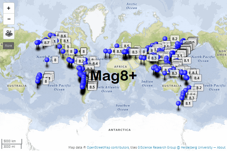
That North Mid Atlantic Ridge M7.0 has got me going again on the M7+ project, I need to start 2015 now.
With the Google changes at the end of Feb, the maps are about to go blank, making the whole thing totally useless.
I've been playing around with Open Street Map.
Its not quite the same, without the custom icons the maps look quite different and I am having trouble getting the popup tags to show the data in lines. Also getting the map to show with the right centre so all the icons show on it has taken me a couple of hours. There is a bit of experimenting to do yet, but I think I can redo the whole thing. Biggest task will be the text on some of the popups, they are not in the CSV files I created, the text was added in Google Earth as KMZ, so having to use KMl I'll have to go through each year and grab the text of each individual event (that has extra text) and copy and paste that in the CSV file.
Due to Wordpress only allowing Google i-frames, the project will have to be transfered to Blogger, which accepts all kinds of HTML.
See what you think, feed back would be welcome, I did a test page, of the year 1997
significantearthquakes.blogspot.co.nz...
here's a screenshot to show what it looks like
the original M7+ project is in my signature, but for those that are not logged in here it is again
45to47south.wordpress.com...
*the W8 type pesky popout menu on the right side is a real PITA, it goes over the menu bar and you can't move the bar. If you read the single page off the main home page its not a problem though.
edit on 02000000444415 by muzzy because: (no reason given)
edit on 02000000444415
by muzzy because: (no reason given)
a reply to: muzzy
It is also on a spreading ridge not a subduction zone so not likely to cause a tsunami.
There have only been 2 there in the last 20 years (500 mile radius of the event today)
The link goes to my post because the link would not work but it does work from that post.
It is also on a spreading ridge not a subduction zone so not likely to cause a tsunami.
There have only been 2 there in the last 20 years (500 mile radius of the event today)
The link goes to my post because the link would not work but it does work from that post.
edit on 14/2/2015 by PuterMan because: because the
link I posted wold not work
a reply to: muzzy
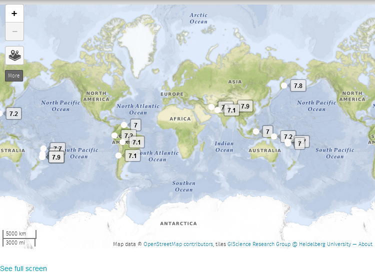
or could go this style, with pins, easier to see the icons?
The pins actually "penetrate" the map where the location is, unlike the ones I experimented with at Christmas.
A little bit more work as I have to change the colour individually, OSM doesn't recognize colour in the CSV file.
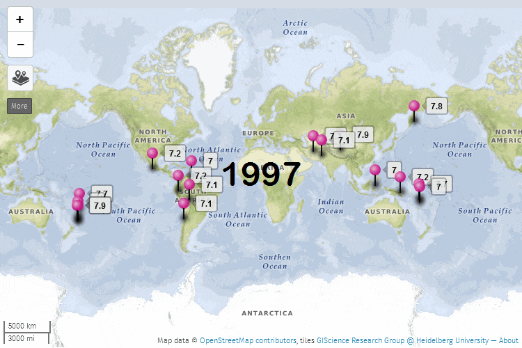
On the 1997 page, the text list has events that have more information highlighted in blue, this presumes the reader has some geographical knowledge to be able to find the pin on the map, in the case of 1997 where Iran, Kamchatka and Tonga are.
the project link again in classic view. As it builds Flipcard becomes the best view, as you can see all the maps and be able to select whichever one you are interested in from there. Flipcard will be the default view when you first arrive at the blog.
or could go this style, with pins, easier to see the icons?
The pins actually "penetrate" the map where the location is, unlike the ones I experimented with at Christmas.
A little bit more work as I have to change the colour individually, OSM doesn't recognize colour in the CSV file.
On the 1997 page, the text list has events that have more information highlighted in blue, this presumes the reader has some geographical knowledge to be able to find the pin on the map, in the case of 1997 where Iran, Kamchatka and Tonga are.
the project link again in classic view. As it builds Flipcard becomes the best view, as you can see all the maps and be able to select whichever one you are interested in from there. Flipcard will be the default view when you first arrive at the blog.
edit on 02u454515 by muzzy because: (no reason given)
had one in Queensland, Australia (around 400-500 klm from me) earlier this morning, was between 5.2 and 5.4 and the 4th in the area in less than a
week.
www.ga.gov.au...
www.ga.gov.au...
a reply to: AkaDeDrow
that's pretty big for Queensland!
there's some kind of Gold Mining operation 39km to the east, south of Perry
www.ga.gov.au...
that's pretty big for Queensland!
there's some kind of Gold Mining operation 39km to the east, south of Perry
www.ga.gov.au...
new topics
-
Thousands Of Young Ukrainian Men Trying To Flee The Country To Avoid Conscription And The War
Other Current Events: 1 hours ago -
12 jurors selected in Trump criminal trial
US Political Madness: 4 hours ago -
Iran launches Retalliation Strike 4.18.24
World War Three: 4 hours ago -
Israeli Missile Strikes in Iran, Explosions in Syria + Iraq
World War Three: 4 hours ago -
George Knapp AMA on DI
Area 51 and other Facilities: 10 hours ago -
Not Aliens but a Nazi Occult Inspired and then Science Rendered Design.
Aliens and UFOs: 10 hours ago
top topics
-
BREAKING: O’Keefe Media Uncovers who is really running the White House
US Political Madness: 17 hours ago, 26 flags -
George Knapp AMA on DI
Area 51 and other Facilities: 10 hours ago, 25 flags -
Israeli Missile Strikes in Iran, Explosions in Syria + Iraq
World War Three: 4 hours ago, 13 flags -
Louisiana Lawmakers Seek to Limit Public Access to Government Records
Political Issues: 12 hours ago, 7 flags -
So I saw about 30 UFOs in formation last night.
Aliens and UFOs: 16 hours ago, 6 flags -
Iran launches Retalliation Strike 4.18.24
World War Three: 4 hours ago, 5 flags -
Not Aliens but a Nazi Occult Inspired and then Science Rendered Design.
Aliens and UFOs: 10 hours ago, 5 flags -
Do we live in a simulation similar to The Matrix 1999?
ATS Skunk Works: 16 hours ago, 4 flags -
The Tories may be wiped out after the Election - Serves them Right
Regional Politics: 14 hours ago, 3 flags -
12 jurors selected in Trump criminal trial
US Political Madness: 4 hours ago, 3 flags
active topics
-
President BIDEN Warned IRAN Not to Attack ISRAEL - Iran Responded with a Military Attack on Israel.
World War Three • 43 • : WeMustCare -
Israeli Missile Strikes in Iran, Explosions in Syria + Iraq
World War Three • 52 • : WeMustCare -
Mandela Effect - It Happened to Me!
The Gray Area • 107 • : inflaymes69 -
Terrifying Encounters With The Black Eyed Kids
Paranormal Studies • 45 • : daskakik -
Not Aliens but a Nazi Occult Inspired and then Science Rendered Design.
Aliens and UFOs • 12 • : BeyondKnowledge3 -
Elites disapearing
Political Conspiracies • 31 • : Degradation33 -
MULTIPLE SKYMASTER MESSAGES GOING OUT
World War Three • 47 • : SchrodingersRat -
12 jurors selected in Trump criminal trial
US Political Madness • 21 • : VictorVonDoom -
British TV Presenter Refuses To Use Guest's Preferred Pronouns
Education and Media • 64 • : Degradation33 -
Iran launches Retalliation Strike 4.18.24
World War Three • 14 • : Cloudbuster1