It looks like you're using an Ad Blocker.
Please white-list or disable AboveTopSecret.com in your ad-blocking tool.
Thank you.
Some features of ATS will be disabled while you continue to use an ad-blocker.

Quake Watch 2015
page: 62share:
further to post by: muzzy about Swarm at Lake Rotoaira
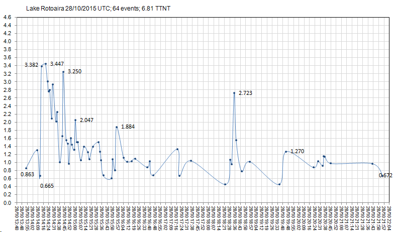
64 count now
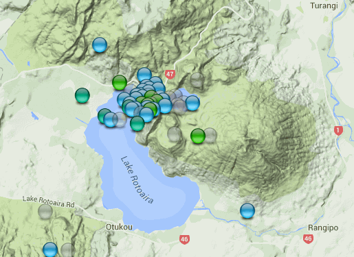
previous swarms in this area
June 2009 Swarm the biggest
Bing interactive map
Not happy with Bing!, the map is only showing 55 of the 64 events, the last one on the map list is the last one on the file, they must select some at random and drop them!
I noticed this on the Japan Bing maps too, not always the claimed max 200 quakes showing when there are 200+ lines on the file.
64 count now
previous swarms in this area
June 2009 Swarm the biggest
Bing interactive map
Not happy with Bing!, the map is only showing 55 of the 64 events, the last one on the map list is the last one on the file, they must select some at random and drop them!
I noticed this on the Japan Bing maps too, not always the claimed max 200 quakes showing when there are 200+ lines on the file.
edit on 1000000030030015 by muzzy because: (no reason given)
Heads up ........sizable quake coming to this area any minute now!
it does not look like much but that will soon change.
M3.0 - 14km SW of Westmorland, California
Time
2015-10-29 00:05:46 (UTC)
2015-10-28 17:05:46 (UTC-07:00) in your timezone
Times in other timezones
Nearby Cities
14km (9mi) SW of Westmorland, California
19km (12mi) W of Brawley, California
19km (12mi) NW of Imperial, California
25km (16mi) NW of El Centro, California
42km (26mi) NW of Mexicali, B.C., MX
1.9
14km SW of Westmorland, California
2015-10-28 17:08:42 UTC-07:009.4 km
3.0
14km SW of Westmorland, California
2015-10-28 17:05:46 UTC-07:0010.1 km
2.3
14km SW of Westmorland, California
2015-10-28 17:05:28 UTC-07:009.9 km
1.7
14km SW of Westmorland, California
2015-10-28 13:24:41 UTC-07:0013.5 km
2.1
14km SW of Westmorland, California
2015-10-28 13:07:46 UTC-07:0010.6 km
it does not look like much but that will soon change.
M3.0 - 14km SW of Westmorland, California
Time
2015-10-29 00:05:46 (UTC)
2015-10-28 17:05:46 (UTC-07:00) in your timezone
Times in other timezones
Nearby Cities
14km (9mi) SW of Westmorland, California
19km (12mi) W of Brawley, California
19km (12mi) NW of Imperial, California
25km (16mi) NW of El Centro, California
42km (26mi) NW of Mexicali, B.C., MX
edit on 7/30/2012 by dreamfox1 because: (no reason given)
1.9
14km SW of Westmorland, California
2015-10-28 17:08:42 UTC-07:009.4 km
3.0
14km SW of Westmorland, California
2015-10-28 17:05:46 UTC-07:0010.1 km
2.3
14km SW of Westmorland, California
2015-10-28 17:05:28 UTC-07:009.9 km
1.7
14km SW of Westmorland, California
2015-10-28 13:24:41 UTC-07:0013.5 km
2.1
14km SW of Westmorland, California
2015-10-28 13:07:46 UTC-07:0010.6 km
edit on 7/30/2012 by dreamfox1 because: (no reason given)
looks like we got a special&intense(for that region) Earthquake right here:
Magnitude ML 4.6
Region PYRENEES
Date time 2015-10-29 00:37:48.4 UTC
Location 42.39 N ; 3.21 E
Depth 10 km
looked for the EQ history in that region and can't find anything higher than 4.6:
earthquaketrack.com...
Magnitude ML 4.6
Region PYRENEES
Date time 2015-10-29 00:37:48.4 UTC
Location 42.39 N ; 3.21 E
Depth 10 km
looked for the EQ history in that region and can't find anything higher than 4.6:
earthquaketrack.com...
edit on 28-10-2015 by Eagleyedobserver because: (no reason given)
a reply to: hiddenNZ
you might not be wrong there
Right under the volcano
deep too ............
ID: 2015p812734 Network: geonet
Status: automatic
Date/Time NZST: 29/10/2015 05:05:20
Date/Time UTC: 28/10/2015 17:05:20
Latitude, Longitude: -39.3008, 175.5947
Magnitude: 3.06M
Depth: 160.625 km
Energy Released: 0.5859 tonnes of TNT
Location: Volcanic Plateau
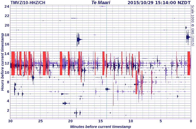
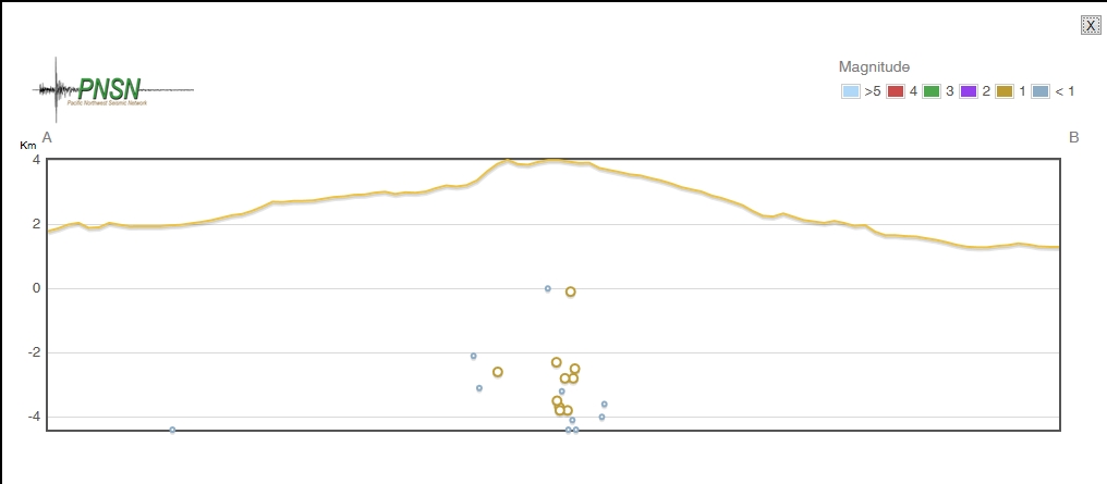
another Drum graph from the north side of Mt. Tongariro (closer to the swarm center than RATZ)
and later in the day off course
www.geonet.org.nz...
you might not be wrong there
Right under the volcano
deep too ............
ID: 2015p812734 Network: geonet
Status: automatic
Date/Time NZST: 29/10/2015 05:05:20
Date/Time UTC: 28/10/2015 17:05:20
Latitude, Longitude: -39.3008, 175.5947
Magnitude: 3.06M
Depth: 160.625 km
Energy Released: 0.5859 tonnes of TNT
Location: Volcanic Plateau
another Drum graph from the north side of Mt. Tongariro (closer to the swarm center than RATZ)
and later in the day off course
www.geonet.org.nz...
edit on 1000000030030015 by muzzy because: (no reason given)
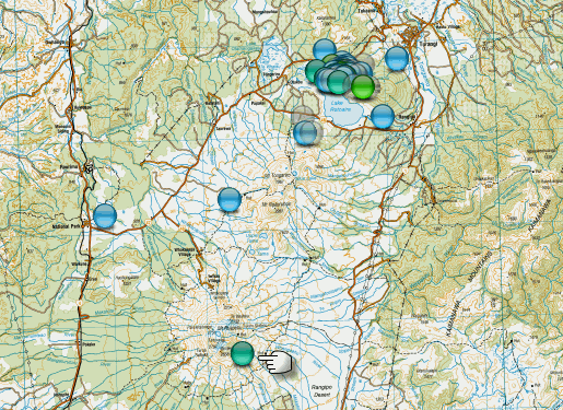
Here is a bit more detailed map (NZ Topo)
rightclickviewimageforfullsize
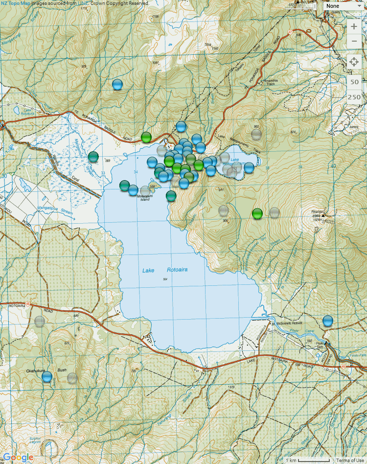
I did a page on it too.here
66 events now, but Bing is only showing 57, not sure what that is about, bloody useless.
looks like it was just a short burst this morning
may come back and do it again, that is how Rotoaira rolls
rightclickviewimageforfullsize
I did a page on it too.here
66 events now, but Bing is only showing 57, not sure what that is about, bloody useless.
looks like it was just a short burst this morning
may come back and do it again, that is how Rotoaira rolls
Hello, folks.
I hesitate.
We must realize that Idaho is related to Nevada/Oregon. Again, within a half hour of each, they are active with slightly larger earthquakes. This time 'round Idaho beat Nevada to the punch. So, it isn't always Idaho replying to Nevada. There are both being influenced by the same thing.
Idaho 2.4M
Nevada 3.9M
There's only one answer.
But I'm repeating myself I'm sure. I resisted the urge yesterday, to post an article on some guy who says the moon has been causing earthquakes. But then today, I see the long pattern of swarms that are quite possibly somehow, maybe, well...
earthquake.usgs.gov...
earthquake.usgs.gov...
Just to correct myself. This Idaho earthquake is not in the same area exactly near Challis.
I hesitate.
We must realize that Idaho is related to Nevada/Oregon. Again, within a half hour of each, they are active with slightly larger earthquakes. This time 'round Idaho beat Nevada to the punch. So, it isn't always Idaho replying to Nevada. There are both being influenced by the same thing.
Idaho 2.4M
Nevada 3.9M
There's only one answer.
But I'm repeating myself I'm sure. I resisted the urge yesterday, to post an article on some guy who says the moon has been causing earthquakes. But then today, I see the long pattern of swarms that are quite possibly somehow, maybe, well...
earthquake.usgs.gov...
earthquake.usgs.gov...
edit on 29-10-2015 by ericblair4891 because: (no reason
given)
Just to correct myself. This Idaho earthquake is not in the same area exactly near Challis.
edit on 29-10-2015 by ericblair4891 because: (no
reason given)
I was just thinking earlier in the week "China hasn't had a moderate-strong quake for a while"
5.1, 2015-10-30 11:26:41.0, 25.11N,99.58E, 10, YUNNAN, CHINA
www.emsc-csem.org...
Looking at EMSC (because their search is the easiest to use)
the last M5 in ALL of China was;
2013-04-22, 5.1, EASTERN NEI MONGOL, CHINA
thats a long time between.
5.1, 2015-10-30 11:26:41.0, 25.11N,99.58E, 10, YUNNAN, CHINA
www.emsc-csem.org...
Looking at EMSC (because their search is the easiest to use)
the last M5 in ALL of China was;
2013-04-22, 5.1, EASTERN NEI MONGOL, CHINA
thats a long time between.
a reply to: muzzy
Actually no, EMSC is as useless as USGS when it comes to searching by place, they have their own area names which are different than the Flinn–Engdahl regions. i selected all the names that had China in them, but obviously it wasn't full coverage.
This was the last M5+ in China, I got it from CENC database, what a mission that was, they have changed all the addresses of the pages I had saved, I had to translate whole pages to find the one I was looking for.
6.5Ms, 2015/07/03 01:07:44.6 ,37.56N ,78.15E ,10 ,SOUTHERN XINJIANG, CHINA
still a while ago, just under 4 months
I didn't include Tibet
edit on 1000000030230215 by muzzy because: (no reason given)
Wooohooo felt that one
rocking and rolling
Public ID 2015p822263
Intensity strong
Universal Time November 1 2015, 5:42:11
NZ Daylight Time Sun, Nov 1 2015, 6:42:11 pm
Depth 39 km
Magnitude 5.4
Location 35 km north-east of Taihape; ENE of Waiouru, New Zealand
www.geonet.org.nz...
2674 felt reports in first 30 minutes
rocking and rolling
Public ID 2015p822263
Intensity strong
Universal Time November 1 2015, 5:42:11
NZ Daylight Time Sun, Nov 1 2015, 6:42:11 pm
Depth 39 km
Magnitude 5.4
Location 35 km north-east of Taihape; ENE of Waiouru, New Zealand
www.geonet.org.nz...
2674 felt reports in first 30 minutes
edit on 1100000030430415 by muzzy because: (no reason given)
M4.3 - 103km W of Ferndale, California
Time
2015-11-02 02:33:59 (UTC)
Nearby Cities
103km (64mi) W of Ferndale, California
113km (70mi) W of Fortuna, California
118km (73mi) WSW of Eureka, California
127km (79mi) WSW of Arcata, California
397km (247mi) WNW of Sacramento, California
earthquake.usgs.gov...
Time
2015-11-02 02:33:59 (UTC)
Nearby Cities
103km (64mi) W of Ferndale, California
113km (70mi) W of Fortuna, California
118km (73mi) WSW of Eureka, California
127km (79mi) WSW of Arcata, California
397km (247mi) WNW of Sacramento, California
earthquake.usgs.gov...
M4.1 - 11km NNE of Black Canyon City, Arizona
Time
2015-11-02 06:29:06 (UTC)
2015-11-01 22:29:06 (UTC-08:00) in your timezone
Times in other timezones
Nearby Cities
11km (7mi) NNE of Black Canyon City, Arizona
28km (17mi) N of New River, Arizona
33km (21mi) N of Anthem, Arizona
49km (30mi) SSW of Camp Verde, Arizona
79km (49mi) N of Phoenix, Arizona
further to post by: muzzy
11 aftershocks up till noon today NZDT
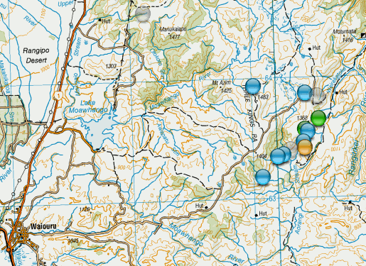
not on any previously known Fault
If you zoom right in on the NZ Topo Map to 1km scale you will see that this earthquake occured within....
"ARMY TRAINING AREA
INTERMITTENT LIVE FIRING
UNAUTHORISED ENTRY PROHIBITED"
Waiouru
Tracking the aftershocks shows a Fault 6.7km long in a SWtoNE direction sort of following the SE base of the Stowman Range
11 aftershocks up till noon today NZDT
not on any previously known Fault
If you zoom right in on the NZ Topo Map to 1km scale you will see that this earthquake occured within....
"ARMY TRAINING AREA
INTERMITTENT LIVE FIRING
UNAUTHORISED ENTRY PROHIBITED"
Waiouru
Tracking the aftershocks shows a Fault 6.7km long in a SWtoNE direction sort of following the SE base of the Stowman Range
edit on 1100000030530515 by muzzy because: (no reason given)
new topics
-
Krystalnacht on today's most elite Universities?
Social Issues and Civil Unrest: 8 minutes ago -
Chris Christie Wishes Death Upon Trump and Ramaswamy
Politicians & People: 35 minutes ago -
University of Texas Instantly Shuts Down Anti Israel Protests
Education and Media: 2 hours ago -
Any one suspicious of fever promotions events, major investor Goldman Sachs card only.
The Gray Area: 4 hours ago -
God's Righteousness is Greater than Our Wrath
Religion, Faith, And Theology: 9 hours ago
top topics
-
VP's Secret Service agent brawls with other agents at Andrews
Mainstream News: 13 hours ago, 10 flags -
Cats Used as Live Bait to Train Ferocious Pitbulls in Illegal NYC Dogfighting
Social Issues and Civil Unrest: 17 hours ago, 8 flags -
Nearly 70% Of Americans Want Talks To End War In Ukraine
Political Issues: 14 hours ago, 5 flags -
Sunak spinning the sickness figures
Other Current Events: 14 hours ago, 5 flags -
Electrical tricks for saving money
Education and Media: 12 hours ago, 4 flags -
Late Night with the Devil - a really good unusual modern horror film.
Movies: 16 hours ago, 3 flags -
Any one suspicious of fever promotions events, major investor Goldman Sachs card only.
The Gray Area: 4 hours ago, 2 flags -
Krystalnacht on today's most elite Universities?
Social Issues and Civil Unrest: 8 minutes ago, 2 flags -
University of Texas Instantly Shuts Down Anti Israel Protests
Education and Media: 2 hours ago, 1 flags -
God's Righteousness is Greater than Our Wrath
Religion, Faith, And Theology: 9 hours ago, 0 flags
active topics
-
University of Texas Instantly Shuts Down Anti Israel Protests
Education and Media • 29 • : CriticalStinker -
I Guess Cloud Seeding Works
Fragile Earth • 41 • : WaESN -
D.C. Court of Appeals made a horrible ruling against Trump
US Political Madness • 320 • : WeMustCare -
Krystalnacht on today's most elite Universities?
Social Issues and Civil Unrest • 1 • : FlyersFan -
New whistleblower Jason Sands speaks on Twitter Spaces last night.
Aliens and UFOs • 58 • : Ophiuchus1 -
SETI chief says US has no evidence for alien technology. 'And we never have'
Aliens and UFOs • 63 • : andy06shake -
Nearly 70% Of Americans Want Talks To End War In Ukraine
Political Issues • 61 • : YourFaceAgain -
Chris Christie Wishes Death Upon Trump and Ramaswamy
Politicians & People • 3 • : ImagoDei -
Hate makes for strange bedfellows
US Political Madness • 45 • : YourFaceAgain -
Post A Funny (T&C Friendly) Pic Part IV: The LOL awakens!
General Chit Chat • 7134 • : baddmove