It looks like you're using an Ad Blocker.
Please white-list or disable AboveTopSecret.com in your ad-blocking tool.
Thank you.
Some features of ATS will be disabled while you continue to use an ad-blocker.

Quake Watch 2015
page: 59share:
a reply to: crappiekat
If anyone has been watching, it has started to slow down.
I just think swarms are interesting. Doesn't mean there's going to be a major earthquake.
I try to study the area, and most of the time I can understand why they might happen in the area.
Kinda scary, Most likely part of the big picture. Lessening tense is a good thing.
a reply to: crappiekat
1.4
1km NNE of San Ramon, California
2015-10-19 23:49:05 UTC-07:007.4 km
1.6
1km NNE of San Ramon, California
2015-10-19 23:19:11 UTC-07:007.3 km
1.7
1km N of San Ramon, California
2015-10-19 23:14:08 UTC-07:006.1 km
1.9
2km NE of San Ramon, California
2015-10-19 22:05:13 UTC-07:007.0 km
2.8
1km NNE of San Ramon, California
2015-10-19 21:33:52 UTC-07:007.5 km
2.9
1km NW of San Ramon, California
2015-10-19 21:33:03 UTC-07:001.3 km
1.4
1km NNE of San Ramon, California
2015-10-19 20:37:56 UTC-07:007.2 km
1.9
1km N of San Ramon, California
2015-10-19 20:30:57 UTC-07:007.2 km
1.4
2km NNE of San Ramon, California
2015-10-19 20:17:41 UTC-07:007.0 km
1.4
2km NE of San Ramon, California
2015-10-19 20:00:40 UTC-07:007.0 km
1.9
2km NE of San Ramon, California
2015-10-19 19:31:07 UTC-07:007.9 km
1.9
2km NNE of San Ramon, California
2015-10-19 19:30:00 UTC-07:008.1 km
1.8
2km NNE of San Ramon, California
2015-10-19 18:48:06 UTC-07:006.9 km
2.5
2km NNE of San Ramon, California
2015-10-19 18:20:51 UTC-07:007.2 km
1.7
2km N of San Ramon, California
2015-10-19 17:59:58 UTC-07:007.1 km
1.3
1km NE of San Ramon, California
2015-10-19 17:46:17 UTC-07:006.8 km
2.5
1km NE of San Ramon, California
2015-10-19 17:44:25 UTC-07:007.5 km
1.9
2km N of San Ramon, California
2015-10-19 17:42:30 UTC-07:006.6 km
1.8
1km NE of San Ramon, California
2015-10-19 17:36:17 UTC-07:007.2 km
1.6
2km N of San Ramon, California
2015-10-19 17:31:18 UTC-07:006.1 km
1.2
2km NNE of San Ramon, California
2015-10-19 17:27:59 UTC-07:007.3 km
2.4
0km WNW of San Ramon, California
2015-10-19 17:22:38 UTC-07:003.8 km
2.2
2km NNE of San Ramon, California
2015-10-19 17:17:01 UTC-07:007.0 km
2.1
2km NNE of San Ramon, California
2015-10-19 17:16:28 UTC-07:007.9 km
1.2
1km NNE of San Ramon, California
2015-10-19 17:16:03 UTC-07:005.1 km
2.1
2km NNE of San Ramon, California
2015-10-19 17:06:13 UTC-07:006.0 km
2.2
2km NNE of San Ramon, California
2015-10-19 16:54:46 UTC-07:007.6 km
1.9
2km NNE of San Ramon, California
2015-10-19 16:51:01 UTC-07:007.4 km
1.3
1km NE of San Ramon, California
2015-10-19 16:41:14 UTC-07:006.3 km
2.0
2km NNE of San Ramon, California
2015-10-19 16:40:47 UTC-07:006.3 km
1.5
2km NE of San Ramon, California
2015-10-19 16:40:14 UTC-07:007.7 km
1.5
2km NE of San Ramon, California
2015-10-19 16:34:33 UTC-07:007.0 km
1.6
1km NE of San Ramon, California
2015-10-19 16:24:37 UTC-07:007.5 km
3.6
1km NE of San Ramon, California
2015-10-19 16:21:17 UTC-07:007.4 km
2.3
1km NE of San Ramon, California
2015-10-19 16:21:11 UTC-07:007.2 km
2.8
1km ENE of San Ramon, California
2015-10-19 16:02:30 UTC-07:008.7 km
1.9
1km NE of San Ramon, California
2015-10-19 14:48:12 UTC-07:006.6 km
1.3
1km NNE of San Ramon, California
2015-10-19 14:25:03 UTC-07:006.6 km
2.0
2km NE of San Ramon, California
2015-10-19 14:24:29 UTC-07:006.9 km
1.4
1km NNE of San Ramon, California
2015-10-19 14:15:39 UTC-07:006.5 km
2.2
1km NE of San Ramon, California
2015-10-19 13:42:57 UTC-07:006.9 km
1.9
1km ENE of San Ramon, California
2015-10-19 13:22:06 UTC-07:007.1 km
1.2
1km ENE of San Ramon, California
2015-10-19 12:13:51 UTC-07:007.6 km
1.9
1km NE of San Ramon, California
2015-10-19 12:10:20 UTC-07:007.7 km
1.2
1km NE of San Ramon, California
2015-10-19 12:02:44 UTC-07:007.0 km
1.9
1km NNE of San Ramon, California
2015-10-19 12:00:46 UTC-07:006.8 km
2.4
2km NE of San Ramon, California
2015-10-19 11:11:27 UTC-07:006.8 km
2.0
1km NNE of San Ramon, California
2015-10-19 10:53:35 UTC-07:007.4 km
1.4
1km NE of San Ramon, California
2015-10-19 10:22:29 UTC-07:008.2 km
2.1
1km NNE of San Ramon, California
2015-10-19 09:36:12 UTC-07:006.9 km
1.6
1km NNE of San Ramon, California
2015-10-19 09:35:59 UTC-07:006.8 km
2.2
1km NNE of San Ramon, California
2015-10-19 09:17:40 UTC-07:006.6 km
1.6
2km NE of San Ramon, California
2015-10-19 08:29:38 UTC-07:006.9 km
1.3
1km ENE of San Ramon, California
2015-10-19 03:06:35 UTC-07:008.3 km
2.0
1km ENE of San Ramon, California
2015-10-19 01:03:24 UTC-07:008.7 km
1.4
1km NNE of San Ramon, California
2015-10-19 23:49:05 UTC-07:007.4 km
1.6
1km NNE of San Ramon, California
2015-10-19 23:19:11 UTC-07:007.3 km
1.7
1km N of San Ramon, California
2015-10-19 23:14:08 UTC-07:006.1 km
1.9
2km NE of San Ramon, California
2015-10-19 22:05:13 UTC-07:007.0 km
2.8
1km NNE of San Ramon, California
2015-10-19 21:33:52 UTC-07:007.5 km
2.9
1km NW of San Ramon, California
2015-10-19 21:33:03 UTC-07:001.3 km
1.4
1km NNE of San Ramon, California
2015-10-19 20:37:56 UTC-07:007.2 km
1.9
1km N of San Ramon, California
2015-10-19 20:30:57 UTC-07:007.2 km
1.4
2km NNE of San Ramon, California
2015-10-19 20:17:41 UTC-07:007.0 km
1.4
2km NE of San Ramon, California
2015-10-19 20:00:40 UTC-07:007.0 km
1.9
2km NE of San Ramon, California
2015-10-19 19:31:07 UTC-07:007.9 km
1.9
2km NNE of San Ramon, California
2015-10-19 19:30:00 UTC-07:008.1 km
1.8
2km NNE of San Ramon, California
2015-10-19 18:48:06 UTC-07:006.9 km
2.5
2km NNE of San Ramon, California
2015-10-19 18:20:51 UTC-07:007.2 km
1.7
2km N of San Ramon, California
2015-10-19 17:59:58 UTC-07:007.1 km
1.3
1km NE of San Ramon, California
2015-10-19 17:46:17 UTC-07:006.8 km
2.5
1km NE of San Ramon, California
2015-10-19 17:44:25 UTC-07:007.5 km
1.9
2km N of San Ramon, California
2015-10-19 17:42:30 UTC-07:006.6 km
1.8
1km NE of San Ramon, California
2015-10-19 17:36:17 UTC-07:007.2 km
1.6
2km N of San Ramon, California
2015-10-19 17:31:18 UTC-07:006.1 km
1.2
2km NNE of San Ramon, California
2015-10-19 17:27:59 UTC-07:007.3 km
2.4
0km WNW of San Ramon, California
2015-10-19 17:22:38 UTC-07:003.8 km
2.2
2km NNE of San Ramon, California
2015-10-19 17:17:01 UTC-07:007.0 km
2.1
2km NNE of San Ramon, California
2015-10-19 17:16:28 UTC-07:007.9 km
1.2
1km NNE of San Ramon, California
2015-10-19 17:16:03 UTC-07:005.1 km
2.1
2km NNE of San Ramon, California
2015-10-19 17:06:13 UTC-07:006.0 km
2.2
2km NNE of San Ramon, California
2015-10-19 16:54:46 UTC-07:007.6 km
1.9
2km NNE of San Ramon, California
2015-10-19 16:51:01 UTC-07:007.4 km
1.3
1km NE of San Ramon, California
2015-10-19 16:41:14 UTC-07:006.3 km
2.0
2km NNE of San Ramon, California
2015-10-19 16:40:47 UTC-07:006.3 km
1.5
2km NE of San Ramon, California
2015-10-19 16:40:14 UTC-07:007.7 km
1.5
2km NE of San Ramon, California
2015-10-19 16:34:33 UTC-07:007.0 km
1.6
1km NE of San Ramon, California
2015-10-19 16:24:37 UTC-07:007.5 km
3.6
1km NE of San Ramon, California
2015-10-19 16:21:17 UTC-07:007.4 km
2.3
1km NE of San Ramon, California
2015-10-19 16:21:11 UTC-07:007.2 km
2.8
1km ENE of San Ramon, California
2015-10-19 16:02:30 UTC-07:008.7 km
1.9
1km NE of San Ramon, California
2015-10-19 14:48:12 UTC-07:006.6 km
1.3
1km NNE of San Ramon, California
2015-10-19 14:25:03 UTC-07:006.6 km
2.0
2km NE of San Ramon, California
2015-10-19 14:24:29 UTC-07:006.9 km
1.4
1km NNE of San Ramon, California
2015-10-19 14:15:39 UTC-07:006.5 km
2.2
1km NE of San Ramon, California
2015-10-19 13:42:57 UTC-07:006.9 km
1.9
1km ENE of San Ramon, California
2015-10-19 13:22:06 UTC-07:007.1 km
1.2
1km ENE of San Ramon, California
2015-10-19 12:13:51 UTC-07:007.6 km
1.9
1km NE of San Ramon, California
2015-10-19 12:10:20 UTC-07:007.7 km
1.2
1km NE of San Ramon, California
2015-10-19 12:02:44 UTC-07:007.0 km
1.9
1km NNE of San Ramon, California
2015-10-19 12:00:46 UTC-07:006.8 km
2.4
2km NE of San Ramon, California
2015-10-19 11:11:27 UTC-07:006.8 km
2.0
1km NNE of San Ramon, California
2015-10-19 10:53:35 UTC-07:007.4 km
1.4
1km NE of San Ramon, California
2015-10-19 10:22:29 UTC-07:008.2 km
2.1
1km NNE of San Ramon, California
2015-10-19 09:36:12 UTC-07:006.9 km
1.6
1km NNE of San Ramon, California
2015-10-19 09:35:59 UTC-07:006.8 km
2.2
1km NNE of San Ramon, California
2015-10-19 09:17:40 UTC-07:006.6 km
1.6
2km NE of San Ramon, California
2015-10-19 08:29:38 UTC-07:006.9 km
1.3
1km ENE of San Ramon, California
2015-10-19 03:06:35 UTC-07:008.3 km
2.0
1km ENE of San Ramon, California
2015-10-19 01:03:24 UTC-07:008.7 km
I got info that may not be good news...
I remember watching some video on youtube days ago. I don't remember the channel but he sounded quite confident while speaking meaning there could be something to what he said.
He said something like: once we would see bigger movement/Magnitude in the carribean plate it may be a sign that a big EQ that triggers a possible tsunami and puts the East coast at risk, may not be far off because Puerto Rico had EQ's for quite some times and it could mean that it is a huge buildup.
Look what just happened:
Magnitude 4.7
Region NE OF BARBUDA, LEEWARD ISLANDS
Date time 2015-10-20 13:57:39.4 UTC
Location 18.71 N ; 60.42 W
Depth 10 km
www.emsc-csem.org...
edit on 20-10-2015 by Eagleyedobserver because: (no reason given)
a reply to: Eagleyedobserver
Thanks for posting.
USGS has nothing on this at the time. I guess that's why we call them useless. LOL!!!!!
They just put it up.
earthquake.usgs.gov...
I would love to see that video, if ya find it.
Thanks for posting.
USGS has nothing on this at the time. I guess that's why we call them useless. LOL!!!!!
They just put it up.
earthquake.usgs.gov...
I would love to see that video, if ya find it.
edit on 20-10-2015 by crappiekat because: (no reason given)
a reply to: crappiekat
no problem.
And it should be real. It's on other sites too > quakes.globalincidentmap.com...
no problem.
And it should be real. It's on other sites too > quakes.globalincidentmap.com...
further to post yesterday by: muzzy
EASTERN TOTTORI PREF SWARM 17-19/10/2015UTC
At 19/10/2015 14:58:22
54 hrs into it;
mag~1= 336
mag1= 69
mag2= 7
mag3= 1
mag4= 2
total= 415
TTNT= 73.888
try the link again;
interactive Bing Map
With so many events it is impossible to make a complete Bing map to cover this, because of the 200 icon limit. So that link only shows the first 200.
I will do a NZ Topo map later, which will show them all. Will post on :japanearthquaes1: as a special, with it's own pie.
here is the best I can do right now;
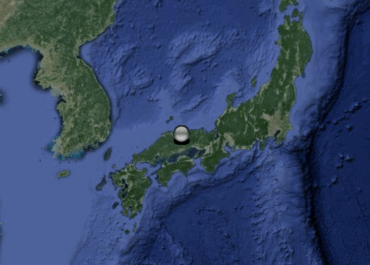
location in Japan
closer
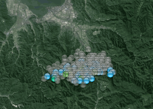
closer
if you follow :japanearthquakes2: you can see from the pies that something important is going on
I got a bit confused this morning with JST/UTC and then breaking out EASTERN TOTTORI PREF to cover 2 days worth, did the downloads and processing 3 times to get it into order.
EASTERN TOTTORI PREF SWARM 17-19/10/2015UTC
At 19/10/2015 14:58:22
54 hrs into it;
mag~1= 336
mag1= 69
mag2= 7
mag3= 1
mag4= 2
total= 415
TTNT= 73.888
try the link again;
interactive Bing Map
With so many events it is impossible to make a complete Bing map to cover this, because of the 200 icon limit. So that link only shows the first 200.
I will do a NZ Topo map later, which will show them all. Will post on :japanearthquaes1: as a special, with it's own pie.
here is the best I can do right now;
location in Japan
closer
closer
if you follow :japanearthquakes2: you can see from the pies that something important is going on
I got a bit confused this morning with JST/UTC and then breaking out EASTERN TOTTORI PREF to cover 2 days worth, did the downloads and processing 3 times to get it into order.
edit on 1000000029229215 by muzzy because: looks like the problem yesterday with the link may have been due to spaces between the words in the
address, changed it to one word today and it works OK
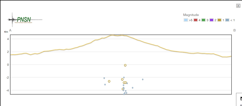
Mt. Rainier continues its few days of movement.
Mag Time (Local) Depth (Km)
1.2 2015/10/19 13:46:43 PDT 2.6
0.8 2015/10/19 13:30:36 PDT 3.1
Source
The question is: Will it continue to rumble around or is this the end for another two weeks? It seems to come in two week spurts.
Bishop
Mag Time (Local) Depth (Km)
1.2 2015/10/19 13:46:43 PDT 2.6
0.8 2015/10/19 13:30:36 PDT 3.1
Source
The question is: Will it continue to rumble around or is this the end for another two weeks? It seems to come in two week spurts.
Bishop
M7.3 - 43km ENE of Port-Olry, Vanuatu
earthquake.usgs.gov...
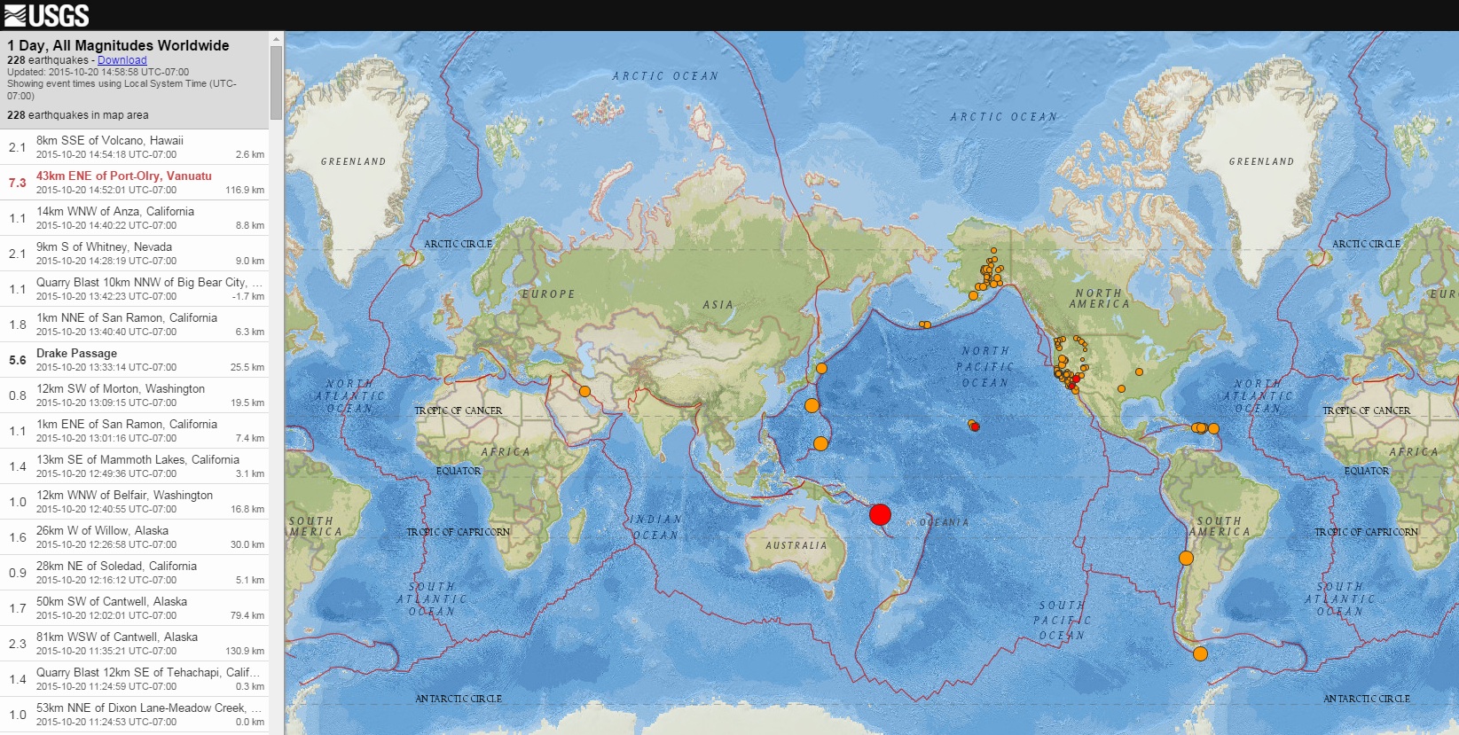
files.abovetopsecret.com...
Time
2015-10-20 21:52:02 (UTC)
2015-10-20 14:52:02 (UTC-07:00) in your timezone
Times in other timezones
Nearby Cities
34km (21mi) NE of Port-Olry, Vanuatu
75km (47mi) NNE of Luganville, Vanuatu
335km (208mi) NNW of Port-Vila, Vanuatu
670km (416mi) N of We, New Caledonia
810km (503mi) N of Paita, New Caledonia
earthquake.usgs.gov...
files.abovetopsecret.com...
Time
2015-10-20 21:52:02 (UTC)
2015-10-20 14:52:02 (UTC-07:00) in your timezone
Times in other timezones
Nearby Cities
34km (21mi) NE of Port-Olry, Vanuatu
75km (47mi) NNE of Luganville, Vanuatu
335km (208mi) NNW of Port-Vila, Vanuatu
670km (416mi) N of We, New Caledonia
810km (503mi) N of Paita, New Caledonia
edit on 7/30/2012 by dreamfox1 because: (no reason given)
M7.3 - 46km NE of Port-Olry, Vanuatu
Time
2015-10-20 21:52:03 (UTC)
Nearby Cities
46km (29mi) NE of Port-Olry, Vanuatu
84km (52mi) NNE of Luganville, Vanuatu
339km (211mi) NNW of Port-Vila, Vanuatu
677km (421mi) N of We, New Caledonia
818km (508mi) N of Paita, New Caledonia
earthquake.usgs.gov...
Time
2015-10-20 21:52:03 (UTC)
Nearby Cities
46km (29mi) NE of Port-Olry, Vanuatu
84km (52mi) NNE of Luganville, Vanuatu
339km (211mi) NNW of Port-Vila, Vanuatu
677km (421mi) N of We, New Caledonia
818km (508mi) N of Paita, New Caledonia
earthquake.usgs.gov...
Just saw that one.
biggest magnitude in quite some time.
biggest magnitude in quite some time.
edit on 20-10-2015 by Eagleyedobserver because: (no reason given)
From USGS.gov
Link to pushback.us
No further damage is currently being reported by TEPCO as a result of this most recent quake. (For whatever THAT is worth)
Magnitude: 5.4
17km SSE of Namie, Japan
2015-10-21
06:04:49 UTC
Depth: 28.2 km
Link to pushback.us
BREAKING: M5.5 quake, 4 on Japanese shindo scale, hits Fukushima & Miyagi prefectures at 3:04 JST; no tsunami warning issued — The Japan Times (@japantimes) October 21, 2015
No further damage is currently being reported by TEPCO as a result of this most recent quake. (For whatever THAT is worth)
edit on
AMq000000amWednesday00000010620 by Aqualung2012 because: (no reason given)
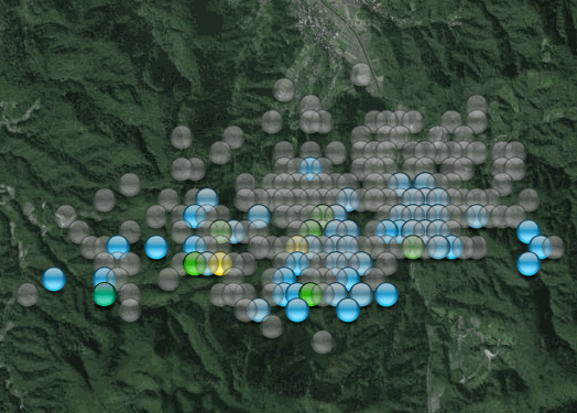
I have redone the Eastern Tottori page, and extended it out to 3 days
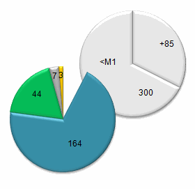
mag~1= 365, mag1= 87 , mag2= 9 , mag3= 3 , mag4= 2 , total= 466 , total energy released= 82.225 TTNT
The confusion yesterday was over a 3.8 that initially showed in the data, but when I processed it 2nd and 3rd time it didn't show.
Started from scratch this morning and it now shows.
Seems this "swarm" did start with that 3.8 at 17/10/2015 17:53:54JST (17/10/2015 08:53:54 UTC) and was a "normal" quake with aftershocks for 14.5 hours, then the 4.2 hit, and 4.3 shortly ( 6:17 minutes) after.
All quite shallow, average depth of 8.3km.
With so many earthquakes within such a small area (4kx2km) many events are on top of each other now.
tottori-pref-swarm
edit: I still haven't figured out how to show that many events on Bing, it would take 3 maps @ 200 per map to show this one.
edit on
1000000029329315 by muzzy because: (no reason given)
a reply to: Aqualung2012
It was just another earthquake in Japan.
As you might have noticed I follow whats happening in Japan quite closely.
Most of that Pushback site is scaremongering
as is the link by Gilbert Davis in the comments
The quake shook skyscrapers in the Japanese capital and temporarily halted the city’s high-speed train service, according to AFP. The trains soon resumed after a track inspection. www.rt.com...
It was just another earthquake in Japan.
As you might have noticed I follow whats happening in Japan quite closely.
Most of that Pushback site is scaremongering
as is the link by Gilbert Davis in the comments
edit on 1000000029329315 by muzzy because: (no reason given)
Couple of Moderate quakes New Zealand (been quiet lately)
One for each island;
Public ID 2015p792999
Intensity severe
Universal Time October 21 2015, 9:49:40
NZ Daylight Time Wed, Oct 21 2015, 10:49:40 pm
Depth 13 km
Magnitude 5.1
Location 145 km west of Tuatapere
Latitude, Longitude -46.16, 165.78
www.geonet.org.nz...
1 hour ago;
Public ID 2015p794154
Intensity strong
Universal Time October 21 2015, 20:05:45
NZ Daylight Time Thu, Oct 22 2015, 9:05:45 am
Depth 18 km
Magnitude 4.8
Location 20 km north of Opunake
Latitude, Longitude -39.28, 173.88
www.geonet.org.nz...
1176 felt reports
edit on 1000000029329315 by muzzy because: (no reason given)
Bit of a repeat of the 13th M5.7 over on the Wairarapa east coast, but a
lot closer.
Had just gone to bed, and was in the twilight zone, almost asleep, bit of a sudden thump , and then the house shook a bit. P wave then S wave.
Public ID 2015p795690
Intensity strong
Universal Time October 22 2015, 9:43:59
NZ Daylight Time Thu, Oct 22 2015, 10:43:59 pm
Depth 6 km
Magnitude 4.4
Location 30 km east of Wellington (Whitemans Valley)
Latitude, Longitude -41.20, 175.08
2948 felt reports
www.geonet.org.nz...
interesting that the Felt Reports map shows no reports from Whitemans Valley itself, which is a small lifestyle blocks/farms area, you would think at 6km depth they would have been shaken to pieces.
Also 5MM "damaging" at Paraparaumu !!!????, not sure about that, didn't seem that violent, could just be some crockery fell off a shelf.
Too bad they don't have a comments page like EMSC has, would be interesting reading.
As it happens I had just watched a documentary on TV about the Nepal 7.8.
Had just gone to bed, and was in the twilight zone, almost asleep, bit of a sudden thump , and then the house shook a bit. P wave then S wave.
Public ID 2015p795690
Intensity strong
Universal Time October 22 2015, 9:43:59
NZ Daylight Time Thu, Oct 22 2015, 10:43:59 pm
Depth 6 km
Magnitude 4.4
Location 30 km east of Wellington (Whitemans Valley)
Latitude, Longitude -41.20, 175.08
2948 felt reports
www.geonet.org.nz...
edit on 1000000029429415 by muzzy because: (no reason given)
interesting that the Felt Reports map shows no reports from Whitemans Valley itself, which is a small lifestyle blocks/farms area, you would think at 6km depth they would have been shaken to pieces.
Also 5MM "damaging" at Paraparaumu !!!????, not sure about that, didn't seem that violent, could just be some crockery fell off a shelf.
Too bad they don't have a comments page like EMSC has, would be interesting reading.
As it happens I had just watched a documentary on TV about the Nepal 7.8.
edit on 1000000029429415 by muzzy because: (no reason given)
M 4.4 - 165km W of Port Hardy, Canada
Time
2015-10-22 14:07:41 UTC-09:00
Location
50.896°N 129.742°W
Depth
12.0 km
Nearby Cities
165km (103mi) W of Port Hardy, Canada
333km (207mi) WNW of Campbell River, Canada
364km (226mi) WNW of Courtenay, Canada
382km (237mi) S of Prince Rupert, Canada
535km (332mi) WNW of Victoria, Canada
earthquake.usgs.gov...
new topics
-
The good, the Bad and the Ugly!
Diseases and Pandemics: 1 hours ago -
Russian intelligence officer: explosions at defense factories in the USA and Wales may be sabotage
Weaponry: 3 hours ago -
African "Newcomers" Tell NYC They Don't Like the Free Food or Shelter They've Been Given
Social Issues and Civil Unrest: 4 hours ago -
Russia Flooding
Other Current Events: 6 hours ago -
MULTIPLE SKYMASTER MESSAGES GOING OUT
World War Three: 6 hours ago -
Two Serious Crimes Committed by President JOE BIDEN that are Easy to Impeach Him For.
US Political Madness: 7 hours ago -
911 emergency lines are DOWN across multiple states
Breaking Alternative News: 7 hours ago -
Former NYT Reporter Attacks Scientists For Misleading Him Over COVID Lab-Leak Theory
Education and Media: 9 hours ago -
Why did Phizer team with nanobot maker
Medical Issues & Conspiracies: 9 hours ago -
Pro Hamas protesters at Columbia claim hit with chemical spray
World War Three: 10 hours ago
top topics
-
Go Woke, Go Broke--Forbes Confirms Disney Has Lost Money On Star Wars
Movies: 14 hours ago, 13 flags -
Pro Hamas protesters at Columbia claim hit with chemical spray
World War Three: 10 hours ago, 11 flags -
Elites disapearing
Political Conspiracies: 12 hours ago, 9 flags -
Freddie Mercury
Paranormal Studies: 14 hours ago, 7 flags -
African "Newcomers" Tell NYC They Don't Like the Free Food or Shelter They've Been Given
Social Issues and Civil Unrest: 4 hours ago, 7 flags -
A Personal Cigar UFO/UAP Video footage I have held onto and will release it here and now.
Aliens and UFOs: 12 hours ago, 5 flags -
Two Serious Crimes Committed by President JOE BIDEN that are Easy to Impeach Him For.
US Political Madness: 7 hours ago, 5 flags -
Russian intelligence officer: explosions at defense factories in the USA and Wales may be sabotage
Weaponry: 3 hours ago, 4 flags -
911 emergency lines are DOWN across multiple states
Breaking Alternative News: 7 hours ago, 4 flags -
Former NYT Reporter Attacks Scientists For Misleading Him Over COVID Lab-Leak Theory
Education and Media: 9 hours ago, 4 flags
active topics
-
Russian intelligence officer: explosions at defense factories in the USA and Wales may be sabotage
Weaponry • 59 • : theatreboy -
African "Newcomers" Tell NYC They Don't Like the Free Food or Shelter They've Been Given
Social Issues and Civil Unrest • 8 • : FlyersFan -
Elites disapearing
Political Conspiracies • 22 • : CitizenB -
I Guess Cloud Seeding Works
Fragile Earth • 22 • : Degradation33 -
Russia Flooding
Other Current Events • 3 • : theatreboy -
-@TH3WH17ERABB17- -Q- ---TIME TO SHOW THE WORLD--- -Part- --44--
Dissecting Disinformation • 520 • : cherokeetroy -
Former NYT Reporter Attacks Scientists For Misleading Him Over COVID Lab-Leak Theory
Education and Media • 3 • : Hakaiju -
Two Serious Crimes Committed by President JOE BIDEN that are Easy to Impeach Him For.
US Political Madness • 9 • : Myhandle -
MULTIPLE SKYMASTER MESSAGES GOING OUT
World War Three • 15 • : cherokeetroy -
A Personal Cigar UFO/UAP Video footage I have held onto and will release it here and now.
Aliens and UFOs • 10 • : Hakaiju