It looks like you're using an Ad Blocker.
Please white-list or disable AboveTopSecret.com in your ad-blocking tool.
Thank you.
Some features of ATS will be disabled while you continue to use an ad-blocker.

Quake Watch 2015
page: 58share:
3.2 Mag earthquake, Iceland near Bardarbunga.
Earthquake table
Date Time Latitude Longitude Depth Magnitude Quality Location
Friday
16.10.2015 06:45:58 64.667 -17.432 1.6 km 3.2 99.0 5.4 km ENE of Bárðarbunga
en.vedur.is...=table
baering.github.io...
Not showing on USGS
Earthquake table
Date Time Latitude Longitude Depth Magnitude Quality Location
Friday
16.10.2015 06:45:58 64.667 -17.432 1.6 km 3.2 99.0 5.4 km ENE of Bárðarbunga
en.vedur.is...=table
baering.github.io...
Not showing on USGS
Magnitude 4.2
Region NORTHERN YUKON TERRITORY, CANADA
Date time 2015-10-16 18:05:45.1 UTC
Location 68.06 N ; 136.29 W
Depth 16 km
www.emsc-csem.org...
just weird...
+
Magnitude 4.5
Region NORTHERN EAST PACIFIC RISE
Date time 2015-10-16 18:45:42.3 UTC
Location 7.97 N ; 103.54 W
Depth 10 km
www.emsc-csem.org...
Region NORTHERN YUKON TERRITORY, CANADA
Date time 2015-10-16 18:05:45.1 UTC
Location 68.06 N ; 136.29 W
Depth 16 km
www.emsc-csem.org...
just weird...
+
Magnitude 4.5
Region NORTHERN EAST PACIFIC RISE
Date time 2015-10-16 18:45:42.3 UTC
Location 7.97 N ; 103.54 W
Depth 10 km
www.emsc-csem.org...
edit on 16-10-2015 by Eagleyedobserver because: (no reason given)
AAAAAAAAAAAAAAAAAAAAAAARRRRRRRRRRRRRRGGGGGGGGGGGGGGGGHHHHHHHHHHHHHHHHHHHHHHHHHHHH
Whatever you do don't click on "view new Bing maps" if you are looking at my Bing map links off NZEQ or Japan quakes.
I thought I would have a look and see whats up
NOW I CAN'T GET THE KMZ FILES TO SHOW!!!!, it keeps reverting to centering over Auckland,NZ
and no matter what I do it the address bar won't take the KMZ address lin.
What a PITA these map people are!
BING is as useless as GOOGLE now
Google did this 10 months ago, and ruined my work
I'll try rebooting my computer and see what happens.
edit: yeah OK, fixed it, there is an option in the bottom right corner to leave Preview, I didn't see it before.
I left them a message "if it ain't broken, don't fix it" and asked if we could have more than 200 icons/markers per map please.
edit2: i have decided the Prefecture graphs are too time consuming.
Instead I'm going to map less than M1 Japanese quakes on a 2nd map per day. I already have the data downloaded, so it shouldn't be that hard. This will pick up the Tremors in the South West of the 4 main islands.
New pies (looks more and more like Pacman)
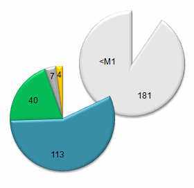
:japanearthquakes2:
Whatever you do don't click on "view new Bing maps" if you are looking at my Bing map links off NZEQ or Japan quakes.
I thought I would have a look and see whats up
NOW I CAN'T GET THE KMZ FILES TO SHOW!!!!, it keeps reverting to centering over Auckland,NZ
and no matter what I do it the address bar won't take the KMZ address lin.
What a PITA these map people are!
BING is as useless as GOOGLE now
Google did this 10 months ago, and ruined my work
I'll try rebooting my computer and see what happens.
edit: yeah OK, fixed it, there is an option in the bottom right corner to leave Preview, I didn't see it before.
I left them a message "if it ain't broken, don't fix it" and asked if we could have more than 200 icons/markers per map please.
edit on 1000000028828815 by muzzy because: (no reason given)
edit2: i have decided the Prefecture graphs are too time consuming.
Instead I'm going to map less than M1 Japanese quakes on a 2nd map per day. I already have the data downloaded, so it shouldn't be that hard. This will pick up the Tremors in the South West of the 4 main islands.
New pies (looks more and more like Pacman)
:japanearthquakes2:
edit on 1000000028828815 by muzzy because: (no reason given)
Ranier's rumbling again. It seems like Mt. Ranier is on a two-week cycle. Every two weeks, it starts to show some activity and then it goes silent
for another two weeks. Could this be related to the tides or the moon?
I suspect that the 0.7 at the top of the list is just the start of this cycle and we will see some more shaking in the next few days before she goes silent again.
Mag Time (Local) Depth (Miles)
0.7 2015/10/17 08:04:57 PDT 2.2
0.1 2015/10/03 07:45:49 PDT 2.2
1.0 2015/10/03 07:45:37 PDT 1.8
0.8 2015/10/03 04:54:27 PDT 2.7
-0.1 2015/10/02 20:43:30 PDT 1.3
0.3 2015/10/02 01:21:54 PDT 2.6
1.5 2015/10/02 01:00:48 PDT 1.4
1.4 2015/10/02 00:58:28 PDT 2.4
0.8 2015/10/02 00:48:57 PDT 2.7
1.6 2015/10/01 23:39:55 PDT 1.8
0.6 2015/10/01 23:14:03 PDT 2.2
0.6 2015/10/01 22:10:43 PDT 2.5
0.1 2015/10/01 21:21:52 PDT 2.3
0.3 2015/10/01 21:20:48 PDT 2.9
0.0 2015/10/01 11:28:46 PDT 1.8
0.8 2015/09/30 01:06:42 PDT 1.2
-0.5 2015/09/19 17:37:26 PDT 1.4
0.4 2015/09/19 17:29:31 PDT 2.6
0.7 2015/09/19 17:21:55 PDT 2.3
1.2 2015/09/14 09:58:20 PDT 2.4
Source
Bishop
a reply to: crappiekat
yeah that's how I look at it too, it is almost like these map people are trying to discourage the use of their products.
I can't see why, even if I had 5000 icons/markers on one map how does it effect the map provider?, the bandwidth being used to view the map is on MY computer, or whoever's computer is looking.
Maybe its because of the NSA spying on everything, they just can't keep up with that amount of volume. We know Google, Apple and Microsoft are providing the NSA with everything that goes on.
Or someone does't want us to know what is really going on
7 quakes (micros's) at Mt Fuji 15/10/2015
edit on 1000000028928915 by muzzy because: (no reason given)
Magnitude 5.1
Region WEST CHILE RISE
Date time 2015-10-17 17:52:20.9 UTC
Location 42.43 S ; 82.45 W
Depth 2 km
www.emsc-csem.org...
Region WEST CHILE RISE
Date time 2015-10-17 17:52:20.9 UTC
Location 42.43 S ; 82.45 W
Depth 2 km
www.emsc-csem.org...
further to: muzzy
At least Bing still works for up to 200 icons, new Google maps is a right-off, absolutely useless for plotting multiple icons.
But it's not as good as the old Classic Google Maps.
example on 12/10/2015 (less than M1) Japan, Hida Mountains.
It is hard to see stacked icons/markers on Bing when you are zoomed out to country wide level.
This screenshot shows the Hida Swarm, you wouldn't know anything is afoot there at all.
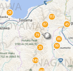
but zoom in ............
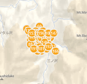
you have to be at 2mile/5km scale before they show as a bunch.
With Google Classic Maps you could see the black shadows from the orb icons at a larger zoom level
At least Bing still works for up to 200 icons, new Google maps is a right-off, absolutely useless for plotting multiple icons.
But it's not as good as the old Classic Google Maps.
example on 12/10/2015 (less than M1) Japan, Hida Mountains.
It is hard to see stacked icons/markers on Bing when you are zoomed out to country wide level.
This screenshot shows the Hida Swarm, you wouldn't know anything is afoot there at all.
but zoom in ............
you have to be at 2mile/5km scale before they show as a bunch.
With Google Classic Maps you could see the black shadows from the orb icons at a larger zoom level
edit on 1000000028928915 by muzzy because: (no reason given)
edit on 1000000028928915 by muzzy because: (no reason
given)
wow many 5 pointers on different fault lines. It just seems super instable at the moment.
www.emsc-csem.org...
www.emsc-csem.org...
edit on 17-10-2015 by Eagleyedobserver because: (no reason given)
a reply to: crappiekat
for a bit of a laugh
pacman animation
made from the Japan Oct pies
seriously though there isn't all that much variation, only once did the ~M1's go over 200, and the M1+'s haven't ... yet
for a bit of a laugh
pacman animation
made from the Japan Oct pies
seriously though there isn't all that much variation, only once did the ~M1's go over 200, and the M1+'s haven't ... yet
edit on 1000000028928915 by muzzy because: (no reason given)
Magnitude 3.7
Region JUJUY, ARGENTINA
Date time 2015-10-18 16:20:59.0 UTC
Location 23.17 S ; 66.95 W
Depth 258 km
Deep EQ's like that can lead to more shallow ones. That is my main concern right now. There have been a bunch of them especially in South america just in the last 12 hours.
+
Magnitude 6.0
Region TONGA
Date time 2015-10-18 16:18:39.0 UTC
Location 16.21 S ; 173.35 W
Depth 40 km
www.emsc-csem.org...
a reply to: Eagleyedobserver
Yep I'm watching.
earthquake.usgs.gov...
Stay off the roof's muzzy. LOL!!!
Yep I'm watching.
earthquake.usgs.gov...
Stay off the roof's muzzy. LOL!!!
a reply to: crappiekat
Actually the roof is a pretty safe place to be in an earthquake. I was on one twice during the Cook Strait M5's in 2013, seen people running out the building, wondered what the fuss was about, we didn't even feel it up there ( 3 stories)
and also up there there is nothing that can fall on you.
Safe in a Tsunami too.
more pluses than minuses I think.
Update on Mt. Rainier.
It seems that yesterday, they had some shaking nearer the surface. This is the shallowest in the last 20 days. I hope that's not a sign of things to come.
Mag Time (Local) Depth (Km)
1.7 2015/10/18 09:03:38 PDT 0.1
Source
Bishop
It seems that yesterday, they had some shaking nearer the surface. This is the shallowest in the last 20 days. I hope that's not a sign of things to come.
Mag Time (Local) Depth (Km)
1.7 2015/10/18 09:03:38 PDT 0.1
Source
Bishop
edit on 10/19/2015 by Bishop2199 because: (no reason given)
edit on 10/19/2015 by Bishop2199 because: (no reason
given)
Here is the latest cross-section of activity for Mt. Rainier.
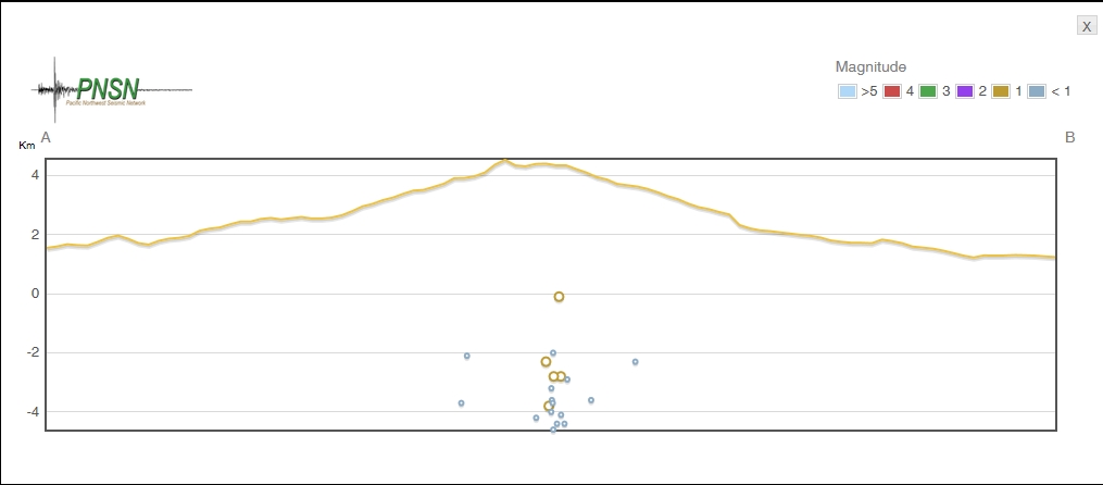
Bishop
Bishop
Near Yurihama, Tottori Prefecture, Honshu
[url=http://www.bing.com/maps/?mapurl=https://dl.dropboxusercontent.com/u/1132313/Japan/2015/EASTERN%20TOTTORI%20PREF%20SWARM%2017102015.kmz]swarm[/ur l]
mag~1= 77
mag1= 49
mag2= 5
mag4= 2
total= 133
TTNT= 73.044
I call it a swarm as the 2 x M4's were in the middle time wise, with what are now 66 foreshocks.
edit on 1000000029129115 by muzzy because: (no reason given)
edit on 1000000029129115 by muzzy because: (no reason
given)
edit on 1000000029129115 by muzzy because: (no reason given)
edit on 1000000029129115 by muzzy because: (no
reason given)
edit on 1000000029129115 by muzzy because: WHAT Now????? won't let me post the link address inside [ url]
brackets
edit on 1000000029129115 by muzzy because: (no reason given)
edit on 1000000029129115 by muzzy because: (no
reason given)
edit on 1000000029129115 by muzzy because: F it I give up
Got alittle swarm going on.
earthquake.usgs.gov...
It's seems to be very active right now.
Just to add. 3.5 is the largest. This is a very populated area, I wonder if they are feeling these.
Anyway, Check it out. Interesting.
earthquake.usgs.gov...
It's seems to be very active right now.
Just to add. 3.5 is the largest. This is a very populated area, I wonder if they are feeling these.
Anyway, Check it out. Interesting.
edit on 19-10-2015 by crappiekat because: to add. Getting forgetful
new topics
-
Electrical tricks for saving money
Education and Media: 39 minutes ago -
VP's Secret Service agent brawls with other agents at Andrews
Mainstream News: 1 hours ago -
Sunak spinning the sickness figures
Other Current Events: 2 hours ago -
Nearly 70% Of Americans Want Talks To End War In Ukraine
Political Issues: 2 hours ago -
Late Night with the Devil - a really good unusual modern horror film.
Movies: 4 hours ago -
Cats Used as Live Bait to Train Ferocious Pitbulls in Illegal NYC Dogfighting
Social Issues and Civil Unrest: 6 hours ago -
The Good News According to Jesus - Episode 1
Religion, Faith, And Theology: 7 hours ago -
HORRIBLE !! Russian Soldier Drinking Own Urine To Survive In Battle
World War Three: 10 hours ago
top topics
-
SETI chief says US has no evidence for alien technology. 'And we never have'
Aliens and UFOs: 16 hours ago, 8 flags -
Cats Used as Live Bait to Train Ferocious Pitbulls in Illegal NYC Dogfighting
Social Issues and Civil Unrest: 6 hours ago, 8 flags -
Florida man's trip overseas ends in shock over $143,000 T-Mobile phone bill
Social Issues and Civil Unrest: 12 hours ago, 8 flags -
VP's Secret Service agent brawls with other agents at Andrews
Mainstream News: 1 hours ago, 6 flags -
Former Labour minister Frank Field dies aged 81
People: 15 hours ago, 4 flags -
Bobiverse
Fantasy & Science Fiction: 12 hours ago, 3 flags -
HORRIBLE !! Russian Soldier Drinking Own Urine To Survive In Battle
World War Three: 10 hours ago, 3 flags -
Nearly 70% Of Americans Want Talks To End War In Ukraine
Political Issues: 2 hours ago, 3 flags -
Sunak spinning the sickness figures
Other Current Events: 2 hours ago, 3 flags -
Late Night with the Devil - a really good unusual modern horror film.
Movies: 4 hours ago, 2 flags
active topics
-
Cats Used as Live Bait to Train Ferocious Pitbulls in Illegal NYC Dogfighting
Social Issues and Civil Unrest • 12 • : Hakaiju -
HORRIBLE !! Russian Soldier Drinking Own Urine To Survive In Battle
World War Three • 28 • : budzprime69 -
Huge ancient city found in the Amazon.
Ancient & Lost Civilizations • 61 • : Therealbeverage -
The Reality of the Laser
Military Projects • 43 • : 5thHead -
VP's Secret Service agent brawls with other agents at Andrews
Mainstream News • 16 • : matafuchs -
Should Biden Replace Harris With AOC On the 2024 Democrat Ticket?
2024 Elections • 49 • : Therealbeverage -
WF Killer Patents & Secret Science Vol. 1 | Free Energy & Anti-Gravity Cover-Ups
General Conspiracies • 32 • : Arbitrageur -
Is there a hole at the North Pole?
ATS Skunk Works • 38 • : Therealbeverage -
SETI chief says US has no evidence for alien technology. 'And we never have'
Aliens and UFOs • 41 • : TheMisguidedAngel -
Naked Eye Supernova Erupting in the T Coronae Borealis
Space Exploration • 13 • : Therealbeverage