It looks like you're using an Ad Blocker.
Please white-list or disable AboveTopSecret.com in your ad-blocking tool.
Thank you.
Some features of ATS will be disabled while you continue to use an ad-blocker.

Quake Watch 2015
page: 43share:
originally posted by: dreamfox1
I post this because were it happened.
earthquake.usgs.gov...
M4.4 - 247km W of Crescent City, California
Time
2015-08-14 06:41:32 (UTC)
2015-08-13 23:41:32 (UTC-07:00) in your timezone
Times in other timezones
Nearby Cities
247km (153mi) W of Crescent City, California
253km (157mi) WNW of Eureka, California
255km (158mi) W of McKinleyville, California
258km (160mi) WNW of Arcata, California
522km (324mi) SW of Salem, Oregon
Fears grow as seismologists warn massive earthquake could hit US northwest coast within 50 years
www.news.com.au... 6frflp0-1227444075836
7.9 Earthquake in California predicted by proven and validated SOURCE * lead-in to volcanic activity
www.abovetopsecret.com...
What are the odds a giant earthquake will devastate Seattle? Experts weigh in.
www.vox.com...
ENVIRONMENT
An Epic Earthquake Is Predicted to Hit the Pacific Northwest — and It’s Totally Terrifying
www.alternet.org...
Is West Coast ready for next big quake?
www.cnn.com...
FEMA official warns: “[…] everything west of Interstate 5 will be toast”, massive natural disaster coming
www.intellihub.com...
Man, I don't know... All of the recent significant quakes were between 6.0-7.2 (and some of them myseriously downgraded rarely you see an upgrade).
I think people tend to forget that the strongest Earthquake this year so far was a 8.5 and it came out of nowhere. They were very lucky that it was very deep.
No doubt this could happen again at a more shallow level in my opinion when people least expect it.
another off QLD, AU. www.abc.net.au...
Offshore E of Fraser Island, QLD.
Magnitude: 4.0 (ML)
Depth: 10 km
Tsunamigenic: No
Date and Time
UTC: 14 August 2015 @ 01:06:55
Sydney Time: 14 August 2015 @ 11:06:55 (AEST)
Location
Coordinates: -25.431, 154.309
www.ga.gov.au...
Offshore E of Fraser Island, QLD.
Magnitude: 4.0 (ML)
Depth: 10 km
Tsunamigenic: No
Date and Time
UTC: 14 August 2015 @ 01:06:55
Sydney Time: 14 August 2015 @ 11:06:55 (AEST)
Location
Coordinates: -25.431, 154.309
www.ga.gov.au...
originally posted by: Eagleyedobserver
I think people tend to forget that the strongest Earthquake this year so far was a 8.5 and it came out of nowhere. They were very lucky that it was very deep.
Oh yeah? where was that?
The largest quake this year (or even in the last 12 months) was a 7.9 at the Bonin Islands
significantearthquakes.blogspot.co.nz...
a reply to: muzzy
I think thats the one I'm talking about. It was initially 8.5 on multiple sites and then 'Downgraded' and it was very deep.
The problem we have we'll never find out what quakes are downgraded for a reason. Measurements can be inaccurate. OK.
But why is it only rarely the other way around? It makes no sense at all unless the sensors are somehow calibrated in a comically over sensitive way which would make even less sense because their goal is to receive accurate measurements. no?
it's really worth it to be sceptical about certain things. So here's your answer...
Edit: I'm not saying it was 8.5 (i'm not god sorry about that) but thats the number that sticks in my brain.
edit on 14-8-2015 by
Eagleyedobserver because: (no reason given)
It's not that they upgrade or downgrade, it is that they change the magnitude type.
Initially when USGS post a quake it is usually mb, and you will find that the mb never changes.
They try to end up with a Mw, there are 4 types of Mw; Mww, Mwp, Mwc, Mwb
types of magnitude
That Bonin Is. quake had a Me reading of;
Me_hf (high frequency) of 8.66 or Me_bb (broadband) 8.28
ds.iris.edu...
Me is the measurement of radiated energy released, and is almost always higher than any of the other readings, but not always.
But the whole point is you have to try and standardize things so that you can compare apples with apples, quakes with quakes, there is no use comparing that Bonin as 8.28Me_bb to say the next biggest quake in the last 12 months, the Nepal quake, at 7.8Mww type. You need to compare it at Me for both (Nepal 7.68Me_bb) or Mww for both. (Bonin 7.8Mww, Nepal, 7.8Mww).
Doing otherwise is selective cherry picking to suit an agenda.
It appears the two quakes chosen have the same magnitude in Mww, but when you look closer the Bonin Is. quake released a lot more energy.
I know its complicated, I drives me crazy when I am processing the data for my maps, that is why I try and show the Me if it is available. Back in the 80's Me was the main magnitude type used for larger quakes.
The biggest contributors to the confusion is the MSM, journalists not doing their research, how many times do you hear on TV News "blah blah blah a quake measuring 7.8 on the Richter Scale hit Nepal today ......". It wouldn't have been The Richter scale which is only useful for quakes below 5 and has slowly been phased out since the 1970's, although the places that have the most quakes such as Japan, California, New Zealand, Greece, Turkey and China still use it.
There is a big gap in the education of the general public in regards to earthquake sizes.
My question was not a personal attack on what you said, I just wondered if I missed something since I posted the data for the earlier part of 2015, I usually give it a week to ensure any adjustments have been made (more magnitude types added) by the networks, and rarely go back later to re-check. When I got back past 1900 it was interesting to see how the magnitude types had been changed recently to Mw, as old data is usually in Ms, the people at the GEM Foundation have been doing a lot of cold case work.
edit on 0800000022522515 by muzzy because:
(no reason given)
Magnitude 5.6
Region NORTHERN MID-ATLANTIC RIDGE
Date time 2015-08-14 18:03:02.9 UTC
Location 21.14 N ; 45.93 W
Depth 10 km
Region NORTHERN MID-ATLANTIC RIDGE
Date time 2015-08-14 18:03:02.9 UTC
Location 21.14 N ; 45.93 W
Depth 10 km
Seeing a unstable Pacific ocean near Australia ,New Zeland , Philippines and Japan. Expect a very large quake to occur in this area from now till
the end of Saturday.
Also Sun shockwave due to arrive on earth this saturday !!!!!!
Also Sun shockwave due to arrive on earth this saturday !!!!!!
edit on 7/30/2012 by dreamfox1 because: (no reason given)
Magnitude Mw 6.6
Region SOLOMON ISLANDS
Date time 2015-08-15 07:47:09.7 UTC
Location 10.92 S ; 163.78 E
Depth 30 km
Distances 451 km E of Honiara, Solomon Islands / pop: 56,298 / local time: 18:47:09.7 2015-08-15
210 km E of Kirakira, Solomon Islands / pop: 1,122 / local time: 18:47:09.7 2015-08-15
EMSC
USGS 6.6
Magnitude 5.2
Region KERMADEC ISLANDS REGION
Date time 2015-08-15 17:29:21.1 UTC
Location 27.03 S ; 176.30 W
Depth 10 km
interesting one. Huge differences in depth in that region. one day it's 10 km the other day it's something like '450'
Region KERMADEC ISLANDS REGION
Date time 2015-08-15 17:29:21.1 UTC
Location 27.03 S ; 176.30 W
Depth 10 km
interesting one. Huge differences in depth in that region. one day it's 10 km the other day it's something like '450'
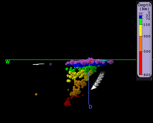
a reply to: Eagleyedobserver
Its a subduction zone, dipping east to west, trenches, ridges, islands, troughs, more ridges, basins, in that order
this is the region in white(the clear section inside the box is "Kermadec Islands", thats another area.)
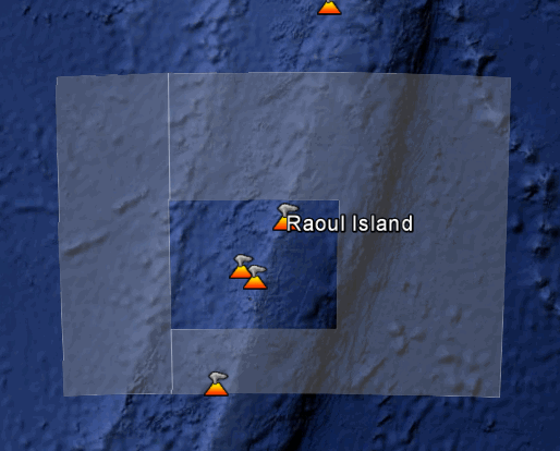
this cross section of that map with some earthquakes plotted by depth, shows the slope of the plate subduction, most of the quakes are on the underside of the Australian Plate on the west side.
Its a subduction zone, dipping east to west, trenches, ridges, islands, troughs, more ridges, basins, in that order
this is the region in white(the clear section inside the box is "Kermadec Islands", thats another area.)
this cross section of that map with some earthquakes plotted by depth, shows the slope of the plate subduction, most of the quakes are on the underside of the Australian Plate on the west side.
edit on 0800000022622615 by muzzy because: (no reason given)
edit on 0800000022622615 by muzzy
because: (no reason given)
Thought this might be of interest, seeing as there is so much activity lately at the Solomon Islands
SOLOMON ISLANDS BIGGEST200 2007-2015 data from EMSC, map by Bing, sorted biggest first. 200 is the limit of icons Bing can show.
Also
the last 200 , latest first. That map includes part of the April 2014 SOLOMON-BOUGAINVILLE PING-PONG MATCH SERIES. Politically Bougainville Is. is part of PNG, but geologically it is part of the Solomon Islands.
and the April 2014 SOLOMON-BOUGAINVILLE PING-PONG MATCH SERIES itself, also last first.
edit on 0800000022622615 by muzzy because: (no reason
given)
Magnitude 5.3
Region NEW IRELAND REGION, P.N.G.
Date time 2015-08-16 21:05:12.3 UTC
Location 5.84 S ; 153.96 E
Depth 73 km
Region NEW IRELAND REGION, P.N.G.
Date time 2015-08-16 21:05:12.3 UTC
Location 5.84 S ; 153.96 E
Depth 73 km
Magnitude M 4.8
Region KEPULAUAN OBI, INDONESIA
Date time 2015-08-16 21:39:42.5 UTC
Location 1.61 S ; 127.49 E
Depth 46 km
Lot of movement around those islands.
and another one on the western side of previous 2 quakes.
Magnitude 4.6
Region ANDAMAN ISLANDS, INDIA REGION
Date time 2015-08-16 21:35:26.9 UTC
Location 13.55 N ; 93.97 E
Depth 60 km
edit on 16-8-2015 by Eagleyedobserver because: (no reason given)
a reply to: crappiekat
Done with the help of IRIS
if you go here and look down in the right hand menu, you will see 3D viewer.
To start you click on the "select region" button on the left hand side and select a box area, then click on "3D viewer", and then use "view" to tilt and rotate.
its a great tool.
Done with the help of IRIS
if you go here and look down in the right hand menu, you will see 3D viewer.
To start you click on the "select region" button on the left hand side and select a box area, then click on "3D viewer", and then use "view" to tilt and rotate.
its a great tool.
What do you make of this? I don't recall Nebraska having earthquakes.
M 3.6 - 35km SE of Thedford, Nebraska
Time 2015-08-19 06:48:38 UTC
Location 41.779°N 100.249°W
Depth 5.0 km
Bishop
M 3.6 - 35km SE of Thedford, Nebraska
Time 2015-08-19 06:48:38 UTC
Location 41.779°N 100.249°W
Depth 5.0 km
Bishop
a reply to: Bishop2199
When I saw that, I too went Hmmm...
So I went here.
earthquake.usgs.gov...
So they do have a history. That plate is being pushed and is scrunching up.
LOL! Sorry for the Non Technical terms.
When I saw that, I too went Hmmm...
So I went here.
earthquake.usgs.gov...
So they do have a history. That plate is being pushed and is scrunching up.
LOL! Sorry for the Non Technical terms.
new topics
-
Who guards the guards
US Political Madness: 18 minutes ago -
Has Tesla manipulated data logs to cover up auto pilot crash?
Automotive Discussion: 2 hours ago -
whistleblower Captain Bill Uhouse on the Kingman UFO recovery
Aliens and UFOs: 7 hours ago -
1980s Arcade
General Chit Chat: 9 hours ago -
Deadpool and Wolverine
Movies: 10 hours ago -
Teenager makes chess history becoming the youngest challenger for the world championship crown
Other Current Events: 11 hours ago
top topics
-
Lawsuit Seeks to ‘Ban the Jab’ in Florida
Diseases and Pandemics: 14 hours ago, 20 flags -
Starburst galaxy M82 - Webb Vs Hubble
Space Exploration: 16 hours ago, 13 flags -
CIA botched its handling of sexual assault allegations, House intel report says
Breaking Alternative News: 12 hours ago, 8 flags -
15 Unhealthiest Sodas On The Market
Health & Wellness: 16 hours ago, 6 flags -
whistleblower Captain Bill Uhouse on the Kingman UFO recovery
Aliens and UFOs: 7 hours ago, 6 flags -
1980s Arcade
General Chit Chat: 9 hours ago, 4 flags -
Deadpool and Wolverine
Movies: 10 hours ago, 3 flags -
Teenager makes chess history becoming the youngest challenger for the world championship crown
Other Current Events: 11 hours ago, 3 flags -
Has Tesla manipulated data logs to cover up auto pilot crash?
Automotive Discussion: 2 hours ago, 0 flags -
Who guards the guards
US Political Madness: 18 minutes ago, 0 flags
active topics
-
New whistleblower Jason Sands speaks on Twitter Spaces last night.
Aliens and UFOs • 40 • : seekshelter -
Michael Avenatti Says He Will Testify FOR Trump
US Political Madness • 59 • : tkwaz -
Who guards the guards
US Political Madness • 0 • : annonentity -
Man possibly killed by werewolf in Texas
Cryptozoology • 27 • : burritocat -
Candidate TRUMP Now Has Crazy Judge JUAN MERCHAN After Him - The Stormy Daniels Hush-Money Case.
Political Conspiracies • 620 • : Threadbarer -
Starburst galaxy M82 - Webb Vs Hubble
Space Exploration • 5 • : Justoneman -
whistleblower Captain Bill Uhouse on the Kingman UFO recovery
Aliens and UFOs • 6 • : Ophiuchus1 -
Deadpool and Wolverine
Movies • 1 • : stosh64 -
Lawsuit Seeks to ‘Ban the Jab’ in Florida
Diseases and Pandemics • 23 • : burritocat -
Has Tesla manipulated data logs to cover up auto pilot crash?
Automotive Discussion • 1 • : andy06shake