It looks like you're using an Ad Blocker.
Please white-list or disable AboveTopSecret.com in your ad-blocking tool.
Thank you.
Some features of ATS will be disabled while you continue to use an ad-blocker.

Quake Watch 2015
page: 10share:
I'm just thinking out-loud. There has been three >3 magnitude earthquakes in northwestern Nevada. The ones listed on the USGS as being closest to
Lakeview, Oregon. In the past I have stated that there is a connection with these quakes and those that have been reoccurring in Idaho.
So, at the moment there is nothing on the Idaho front. If the quakes are connected, there should be something in Idaho really soon. Hmmm. I've been trying to ignore any news on the ongoing swarm in Nevada, because I do that from time to time. Try to forget, by remembering to ignore. But I can only go so far. I need to see the the scientist think about the swarm. In all honesty, I know I will find whatever they have to say about it, it will be non-committal.
To update, there have four >3M in northern Nevada. 19 earthquakes in total for the day when you include the tiny ones.
edit on 3-3-2015 by
ericblair4891 because: (no reason given)
a reply to: ericblair4891
Like you said Idaho...
M 2.9 - 5km E of Challis, Idaho
DYFI? - II
Time2015-03-04 10:23:49 UTC
Location44.512°N 114.159°W
Depth7.7 km
Like you said Idaho...
M 2.9 - 5km E of Challis, Idaho
DYFI? - II
Time2015-03-04 10:23:49 UTC
Location44.512°N 114.159°W
Depth7.7 km
edit on 4-3-2015 by SeekingDepth because: missed a word
data e ora italiana: 04/03/2015 01:00
magnitudo: 3.7
profonditá: 8.9 km
distretto sismico: Zona Chianti
cnt.rm.ingv.it...
not a major one, but caught my eye on Geofon last night where they had it as 4.2Mw
now changed down to 3.9Mw
geofon.gfz-potsdam.de...
5 others in the swarm
magnitudo: 3.7
profonditá: 8.9 km
distretto sismico: Zona Chianti
cnt.rm.ingv.it...
not a major one, but caught my eye on Geofon last night where they had it as 4.2Mw
now changed down to 3.9Mw
geofon.gfz-potsdam.de...
5 others in the swarm
Well now, that Idaho quake was right on schedule. I am very excited because this proves my hypothesis. I was able to accurately able to predict. But
the mystery is not solved. This only prove there is a connection between the Nevada swarm and Idaho. One could argue that it is sympathetic stress
from tectonic forces. There is a study which suggests that inter-continental earthquakes are different from coastal. To make the point brief,
earthquakes in one part of the continent can squeeze and stress other parts causing earthquakes in nearby zones. Like people bumping around in a
crowded elevator. This is not my belief. It's possible. But we're talking nearly 1000km of influence. I think not.
I think this is a fluid thing. Hence, the delay. That's the moving fluid. By following the quakes, you can follow the movement.
Next, it may be right to keep watching Yeller' to see if the staled uplift changes, and or, there are any vigorous swarms. There have been swarms. But very small. That Boiling River story had me thinking. But I don't think there has to be more than just a normal flucuation to explain that one. What do I know?
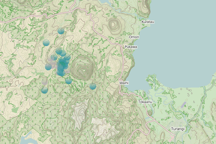
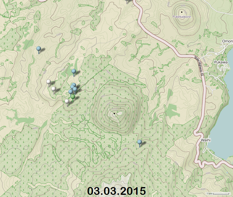
West of Kuharua volcanic cone, 15 km north-west of Turangi, SE corner of Lake Taupo (volcano)
34 quake swarm, 32 of them in 24 hours, all small though, 5-12km deep, most at 7-8km
Largest was a M2.44 but it was the 9th in the swarm.
rightclickviewimagelarger size
Not sure what that was about
there have been swarms in this general area before, but a tad south of Kuharua, some real big ones, I'd send you the link to those but its busted thanks to Google Maps now.
further to: muzzy
I knew there was something familiar about this small series, but couldn't recall, south of Florence.
here it is, this last lot was a bit to the west of the earlier swarm
translation from Italian
I knew there was something familiar about this small series, but couldn't recall, south of Florence.
here it is, this last lot was a bit to the west of the earlier swarm
At the time (07:00 of March 4, 2015) are more than 530 earthquakes occurred in this area since December 18, 2014, the majority of which are of a magnitude less than 3.0, and a single event that has reached magnitude 4.1 on December 19 at 11:36 hours .
translation from Italian
Can anyone here have a look at NZ EQ 2015 for me and tell me if the NZ Topo Maps are working?
nzeq2015.blogspot.co.nz...
I'm getting
HTTP Error 404 - File or directory not found.
Internet Information Services (IIS)
this is genuine request, I'm not fishing for readers.
It may just be a temporary thing, or it could be Google has sabotaged NZ Topo as well as everyone else.
The show must go on, therefore I have done 05.03.2015 on OSM
what do you think? I can't get colours, but I can get labels.
OMG if NZ Topo is out of action .................
how many times do I have to redo these files?
a reply to: muzzy
Being the pessimist I am, I've set up Japan on OSM as well just now
the more I do of these the better I like it, just got to get over the lack of magnitude colouring.
Japan is a bit different to NZ however, as we have both preliminary/automatic and reviewed rolling over every 2-3 days
what I may do is change the colours of those, such as green for reviewed and gray for automatic
japanquakes.blogspot.co.nz...
edit on 03000000636315 by muzzy because: changed the link
This morning there was one 2.5 M earthquake in Northern Nevada. I am thinking this should set off an Idaho quake. But I don't know. Since we had four
+2.5M the day before yesterday, this may be a left over. And, if so, this may not mean an Idaho earthquake. When the "Lakeview" (I'll call them
that since the USGS keeps listing Lakeview Oregon as the nearest main city) +2.5M come as singles, they can set off a single Idaho quake. But like I
said, this cluster was slightly more vigorous and this quake may not get a reply from Idaho.
a reply to: muzzy
Sorry to go on ...........
This is a mapping crisis in process, what to do?, which map system? which is most reliable?
NZ Topo maps has some issues, especially when it comes to putting out Japan data, as mentioned previously.
I'm going to go with OSM for Japan.
I have written a Navigation Guide for those new to OSM (like myself)
I just discovered how to use the "browse data" menu, handy if you want to find the biggest quake, OSM automatically lists them in size smallest to largest. You can do as described on the daily page too, but the menu shows below the map, it is better to go "view full screen".
Navigation page
I could manually change the colour of the icons one by one, but that is way too much work, especially if there are a lot of M3's, and I would have to set the limit to M2+ as there are too many 1's and 2's per day to split them by colour.
Thank you for your patience.
more : muzzy
I've done a trial for NZ too, 5th and 6th March
M~2=Grey
M3=Black
M4=Yellow
M5=Orange
Will see how it goes, already doubled the readers in 2 consecutive days!
nzeq2015.blogspot.co.nz...
edit: maybe there is a whole bunch of people who are interested in earthquakes and who are colour blind!
and prefer pins to circles
question: can you see the circles in B&W?, never thought of that.
(My Dad is colour blind)
edit on 03u646415 by muzzy because: (no reason given)
a reply to: muzzy
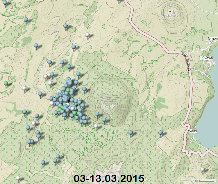
another flurry of quakes at Kuharua, W of Turangi and SW of Lake Taupo
all less than 2.81
most are 1's except that 2.81 and a 2.34
interactive OSM pin map
play around with the stack of papers under the "more" button to get other map backgrounds. The screenshot below is in Open Cycle Map, shows good contour of the landscape

rightclickviewimageforfullsize
another flurry of quakes at Kuharua, W of Turangi and SW of Lake Taupo
all less than 2.81
most are 1's except that 2.81 and a 2.34
interactive OSM pin map
play around with the stack of papers under the "more" button to get other map backgrounds. The screenshot below is in Open Cycle Map, shows good contour of the landscape
rightclickviewimageforfullsize
I've been wrong before, but it works most of the time
TTNT count for NZ yesterday was 8, below the Muzzys Rule threshold of 10, a warning for Mag 5+ coming to NZ.
graph
The next thing I look for is, anything to the SW on the Pacific-Antarctic Ridge?
Yep
Its a small one, but there is movement down there
2015/3/10 0:24:16, -56.75, -142.25, 33.0, M4.8, PACIFIC-ANTARCTIC RIDGE
www.ldeo.columbia.edu...
last 5+ was 17/2/2015, East Cape Ridge Off NI N.Z.
www.geonet.org.nz...
last one on land 13/1/2015, Dusky Sound
www.geonet.org.nz...
M6.2 - 14km N of Aratoca, Colombia
Event Time
2015-03-10 20:55:43 (UTC)
Nearby Cities
14km (9mi) N of Aratoca, Colombia
18km (11mi) SSE of Piedecuesta, Colombia
27km (17mi) SSE of Floridablanca, Colombia
31km (19mi) SSE of Giron, Colombia
272km (169mi) NNE of Bogota, Colombia
earthquake.usgs.gov...
Event Time
2015-03-10 20:55:43 (UTC)
Nearby Cities
14km (9mi) N of Aratoca, Colombia
18km (11mi) SSE of Piedecuesta, Colombia
27km (17mi) SSE of Floridablanca, Colombia
31km (19mi) SSE of Giron, Colombia
272km (169mi) NNE of Bogota, Colombia
earthquake.usgs.gov...
a reply to: Darkblade71
I see your 6.2 and raise you 0.4
QUE EL DÍA 10 DE MARZO DE 2015 A LAS 3:55:44 P.M.
HORA LOCAL (2015-03-10 20:55:44 HORA UT),
SE PRESENTÓ UN SISMO DE MAGNITUD Mw 6.6
CON EPICENTRO A 7.37 K.M AL NOROESTE DE LA CABECERA MUNICIPAL DE LOS SANTOS (SANTANDER).
LATITUD = 6.80 GRADOS NORTE
LONGITUD = -73.15 GRADOS OESTE
PROFUNDIDAD = 161 KILÓMETROS
MAGNITUD = 6.6 Mw
SENTIDO EN: SANTANDER, NORTE DE SANTANDER, BOYACA, CUNDINAMARCA, ANTIOQUIA, CALDAS, CASANARE, QUINDIO, RISARALDA, BOLIVAR, VALLE DEL CAUCA, TOLIMA, CORDOBA, ATLANTICO, MAGADALENA, ARAUCA, META, CESAR, SUCRE, VENEZUELA.
seisan.sgc.gov.co...
right in the middle of the Los Santos Earthquake Zone, its a mining area, gets 400-500 earthquakes a month average, M1-M5. I'd send ya to the Columbian interactive maps I made but Google terminated the operation in Feb.
eqarchives.wordpress.com...
edit on 03u686815 by muzzy because: (no reason given)
Forgive my intrusion here please. I hope the following makes sense to you.
A 5mag has just occurred on the Atlantic ridge across from mid-northern South America at a depth of 10 km. I have always been under the impression that expansion at the ridge is a constant. However I am trying to figure out why the 10 km depth and why such a high magnitude in the ridge itself. Does this indicate that there's a high degree of resistance from the plates to the east and west themselves? Or that at that depth it's just about splitting a hard rock or two at that ridge location itself?
Is my thinking wrong about that? Is 10 km a magic number of sorts across the planet, as many quakes seem to happen at that depth?
Thanks for your replies.
a reply to: aboutface
10km is a default depth, as is 33km, you see it on many networks at those depths (GFZ, EMSC, LDEO, and GSRAS for example)
The USGS tend to try and get more accurate depths if possible.
No answer to the other question really, a M5 quake is a decent size, in subduction an earthquake is the release of a piece of plate that has become snagged, may be different in the spreading situation, or maybe its the same.
edit on 03u717115 by muzzy because: (no reason given)
follow up to: muzzy
this small swarm is still going on, maybe this gif animation might show something, maybe not
rightclick"viewimage"forfullsize
here is the full series so far cumulative (one image) 111 earthquakes
this small swarm is still going on, maybe this gif animation might show something, maybe not
rightclick"viewimage"forfullsize
here is the full series so far cumulative (one image) 111 earthquakes
edit on 03000000717115 by muzzy because: (no reason given)
wooohoooo
major breakthrough using Open Street Maps (OSM) for plotting earthquakes.
the issue for me has not being able to show the magnitudes by colour, on OSM if you load a KML file all the icons are the same colour.
Just figured out how its done
by adding layers. doh!
The only down side is the daily KML has to be split back at the Excell CSV stage and a KML created for each magnitude.
But it works!
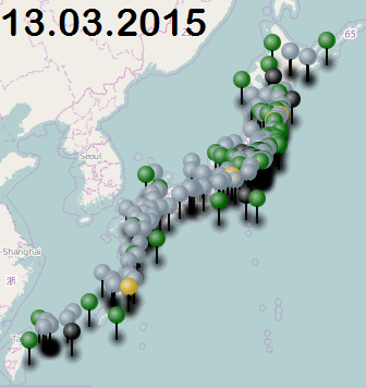
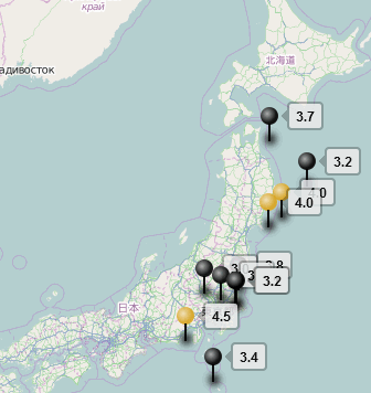
I have done Japan 13.03.2015 for a starter. This file is a combination of JMA and NIED data, so is not final yet.
Japan 13.03.2015
here are a couple of screenshots of how it looks in various formats i.e. overview, without tags, with tags
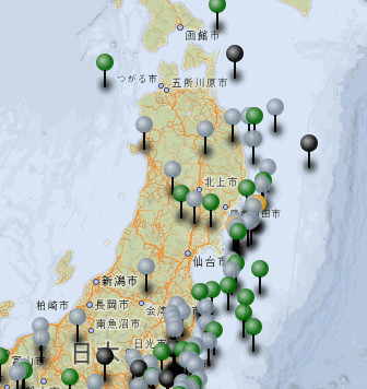
and another advantage of splitting the files is that you can turn on and off whichever magnitude you like, so the people who can't be bothered with the M1s and M2s can turn them off if they want to.
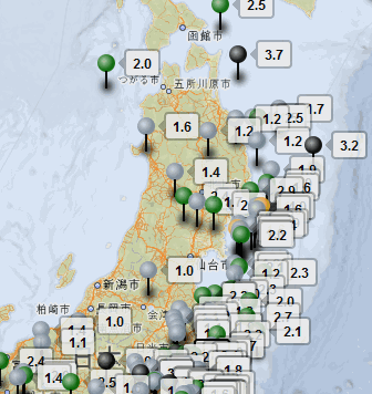
This SS show just the M3's and M4's for the 13th
I guess I could split it into JMA and NIED files too and show those as different coloured icons if there was a need.
I have kept the magnitude colours as close as I can to my old colour scheme, although they are a little darker, OSM icons show quite brightly in the lighter colours, which saturate the ball on top of the pins, and hence don't show as 3D.
I've written up navigation instructions with a new icon key and put it on the Navigation page of the blog.
Japan OSM Navigation
NZ upgrade will follow later today.
The trouble with OSM and Umap is that there are basically no instructions on how to use it, you have to figure it out yourself.
major breakthrough using Open Street Maps (OSM) for plotting earthquakes.
the issue for me has not being able to show the magnitudes by colour, on OSM if you load a KML file all the icons are the same colour.
Just figured out how its done
by adding layers. doh!
The only down side is the daily KML has to be split back at the Excell CSV stage and a KML created for each magnitude.
But it works!
I have done Japan 13.03.2015 for a starter. This file is a combination of JMA and NIED data, so is not final yet.
Japan 13.03.2015
here are a couple of screenshots of how it looks in various formats i.e. overview, without tags, with tags
and another advantage of splitting the files is that you can turn on and off whichever magnitude you like, so the people who can't be bothered with the M1s and M2s can turn them off if they want to.
This SS show just the M3's and M4's for the 13th
I guess I could split it into JMA and NIED files too and show those as different coloured icons if there was a need.
I have kept the magnitude colours as close as I can to my old colour scheme, although they are a little darker, OSM icons show quite brightly in the lighter colours, which saturate the ball on top of the pins, and hence don't show as 3D.
I've written up navigation instructions with a new icon key and put it on the Navigation page of the blog.
Japan OSM Navigation
NZ upgrade will follow later today.
The trouble with OSM and Umap is that there are basically no instructions on how to use it, you have to figure it out yourself.
edit on 03u727215 by muzzy because: (no reason given)
edit on 03000000727215 by muzzy because: (no reason given)
new topics
-
SETI chief says US has no evidence for alien technology. 'And we never have'
Aliens and UFOs: 1 hours ago -
This is our Story
General Entertainment: 4 hours ago -
President BIDEN Vows to Make Americans Pay More Federal Taxes in 2025 - Political Suicide.
2024 Elections: 6 hours ago -
Ode to Artemis
General Chit Chat: 7 hours ago -
Ditching physical money
History: 10 hours ago -
One Flame Throwing Robot Dog for Christmas Please!
Weaponry: 11 hours ago -
Don't take advantage of people just because it seems easy it will backfire
Rant: 11 hours ago
top topics
-
University student disciplined after saying veganism is wrong and gender fluidity is stupid
Education and Media: 15 hours ago, 14 flags -
President BIDEN Vows to Make Americans Pay More Federal Taxes in 2025 - Political Suicide.
2024 Elections: 6 hours ago, 10 flags -
One Flame Throwing Robot Dog for Christmas Please!
Weaponry: 11 hours ago, 6 flags -
Should Biden Replace Harris With AOC On the 2024 Democrat Ticket?
2024 Elections: 12 hours ago, 6 flags -
Ditching physical money
History: 10 hours ago, 4 flags -
Don't take advantage of people just because it seems easy it will backfire
Rant: 11 hours ago, 4 flags -
God lived as a Devil Dog.
Short Stories: 16 hours ago, 3 flags -
SETI chief says US has no evidence for alien technology. 'And we never have'
Aliens and UFOs: 1 hours ago, 3 flags -
VirginOfGrand says hello
Introductions: 12 hours ago, 2 flags -
Ode to Artemis
General Chit Chat: 7 hours ago, 2 flags
active topics
-
SETI chief says US has no evidence for alien technology. 'And we never have'
Aliens and UFOs • 9 • : Consvoli -
University student disciplined after saying veganism is wrong and gender fluidity is stupid
Education and Media • 32 • : BedevereTheWise -
So this is what Hamas considers 'freedom fighting' ...
War On Terrorism • 227 • : HopeForTheFuture -
Remember These Attacks When President Trump 2.0 Retribution-Justice Commences.
2024 Elections • 51 • : Justoneman -
British TV Presenter Refuses To Use Guest's Preferred Pronouns
Education and Media • 131 • : FlyersFan -
Spectrophilia - Women Who Have Had Affairs With Ghosts Say Spooks Are Better Lovers Than Real Men
Paranormal Studies • 30 • : FlyersFan -
Breaking Baltimore, ship brings down bridge, mass casualties
Other Current Events • 471 • : bally001 -
-@TH3WH17ERABB17- -Q- ---TIME TO SHOW THE WORLD--- -Part- --44--
Dissecting Disinformation • 639 • : Justoneman -
Republican Voters Against Trump
2024 Elections • 289 • : Justoneman -
The Acronym Game .. Pt.3
General Chit Chat • 7742 • : bally001