It looks like you're using an Ad Blocker.
Please white-list or disable AboveTopSecret.com in your ad-blocking tool.
Thank you.
Some features of ATS will be disabled while you continue to use an ad-blocker.

Somewhere in Australia...
page: 2share:
a reply to: Shana91aus
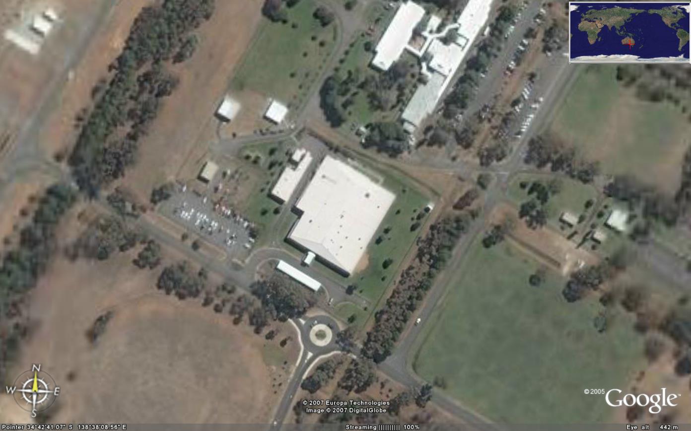
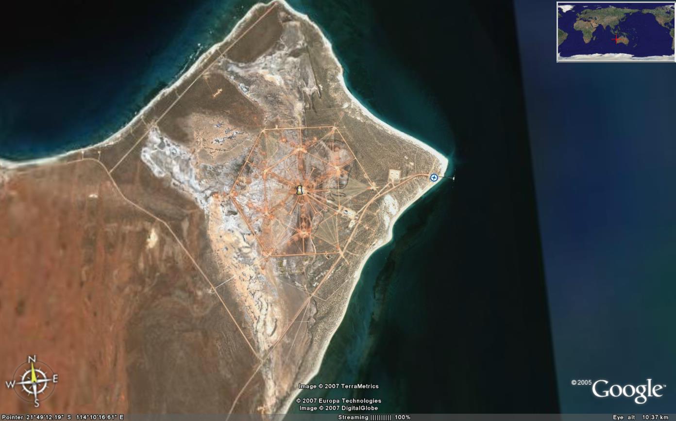
It's called, Harold E. Holt naval communications station, it provides VLF communications to the Australian and US navies.
There's also Jindalee OTH radar station, an Echelon base near Geraldton, Pine gap and Woomera.
It's called, Harold E. Holt naval communications station, it provides VLF communications to the Australian and US navies.
There's also Jindalee OTH radar station, an Echelon base near Geraldton, Pine gap and Woomera.
a reply to: Chadwickus
thankyou so much for the info!
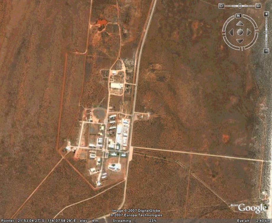
Just googled the Exmouth one some pretty interesting stories surrounding it like this Link, I wonder if theres anything sinister happening with all them massive antennas surely normal radio signals couldn't mess with a plane to that extent? although I do know they are sensitive to that kind of thing so maybe, I can't find anything to do with what the investigation in to the incident I lnked above concluded though.
thankyou so much for the info!
Just googled the Exmouth one some pretty interesting stories surrounding it like this Link, I wonder if theres anything sinister happening with all them massive antennas surely normal radio signals couldn't mess with a plane to that extent? although I do know they are sensitive to that kind of thing so maybe, I can't find anything to do with what the investigation in to the incident I lnked above concluded though.
a reply to: Chadwickus
Nurrunga is nothing but ruins now . I was there in the 80s and it was pretty full on . However Woomera has 300 people now and about 80 AFP officers .
Nurrunga is nothing but ruins now . I was there in the 80s and it was pretty full on . However Woomera has 300 people now and about 80 AFP officers .
a reply to: Chadwickus
I think the British are developing there own version of a drone at the moment . Hanger 5 is the big question .
I think the British are developing there own version of a drone at the moment . Hanger 5 is the big question .
The resolution is pretty poor, but my guess is that is possibly a disused gas well site (as there is gas in this area). Other than that it's likely
a water pump/well-head or a cattle collection point. Possibly an Aboriginal site. Lake Eyre is pretty desolate, but there are cattle and there is a
few gas stations.
Doubtful that it's military or HAARP when looking at the real world.
Regards
Doubtful that it's military or HAARP when looking at the real world.
Regards
originally posted by: Chadwickus
It's called, Harold E. Holt naval communications station, it provides VLF communications to the Australian and US navies.
There's also Jindalee OTH radar station, an Echelon base near Geraldton, Pine gap and Woomera.
The OP is pointing to an area near Lake Eyre, so Harold E Holt is in the wrong part of Oz, which is incidentally a hexagonal structure. Jindalee is also in the wrong part of Oz, as is Geraldton. Woomera and Pine Gap are two or three hundred miles away. Therefore, it's none of these.
Regards
This is a water dam. They are common in Australian outback areas. We have a sheep property of 73,000 acres and there are about 20 of these dams on it
(although only 16 hold water) all visible from google. The square design is due to ease for machinery to dig them in the first place, the old timers
dug them with horses and dam scoops, those dams are genraly oval shaped. The tracks leading in are gutters that catch run off water from the
surrounding area in the event of good rain, the small hole is called the "catch" and is created to allow sediment and debris from the gutters to
settle before entering the main dam and silting up the bottom. A lot of sheep and cattle properties are in remote areas, our station is 80km (50
miles) from the nearest town and even then the town has less than 400 people,we live in the town. Driving from town to our station we only pass two
other homes (both station homesteads also) between the town and our station there would be 100 or more of these dams scattered through that part of
the country.
Cheers, Lindsay.
Cheers, Lindsay.
Interesting, why doesn't some Australian on the board take a drive out there and have a look tomorrow, I mean, how far could it be?
a reply to: Shana91aus
Not officially bases I guess... shared "joint" bases... just google Im sure its out there somewhere. Start in Alice springs then look out in the desert like the op did here.
edit- I guess I can share if its on google huh.. check out pine gap. then on some of these conspiracy websites you can see what some people like the op did here and are closer to the truth than they know. gl
edit on 29-10-2014 by ArmyOfNobunaga because: edit
originally posted by: LindsayK
This is a water dam. They are common in Australian outback areas. We have a sheep property of 73,000 acres and there are about 20 of these dams on it (although only 16 hold water) all visible from google. The square design is due to ease for machinery to dig them in the first place, the old timers dug them with horses and dam scoops, those dams are genraly oval shaped. The tracks leading in are gutters that catch run off water from the surrounding area in the event of good rain, the small hole is called the "catch" and is created to allow sediment and debris from the gutters to settle before entering the main dam and silting up the bottom. A lot of sheep and cattle properties are in remote areas, our station is 80km (50 miles) from the nearest town and even then the town has less than 400 people,we live in the town. Driving from town to our station we only pass two other homes (both station homesteads also) between the town and our station there would be 100 or more of these dams scattered through that part of the country.
Cheers, Lindsay.
Did you specifically join to add this post?
edit on 29-10-2014 by EA006 because: (no reason given)
originally posted by: EA006
originally posted by: LindsayK
This is a water dam. They are common in Australian outback areas. We have a sheep property of 73,000 acres and there are about 20 of these dams on it (although only 16 hold water) all visible from google. The square design is due to ease for machinery to dig them in the first place, the old timers dug them with horses and dam scoops, those dams are genraly oval shaped. The tracks leading in are gutters that catch run off water from the surrounding area in the event of good rain, the small hole is called the "catch" and is created to allow sediment and debris from the gutters to settle before entering the main dam and silting up the bottom. A lot of sheep and cattle properties are in remote areas, our station is 80km (50 miles) from the nearest town and even then the town has less than 400 people,we live in the town. Driving from town to our station we only pass two other homes (both station homesteads also) between the town and our station there would be 100 or more of these dams scattered through that part of the country.
Cheers, Lindsay.
Did you specifically join to add this post?
Been lurking for many years, lost my original password and changed email address so had to re join, but yes, re joined specifically to post that comment. Only trying to help, the google image was unidentified, now it isn't, I though that was the idea.
originally posted by: ArmyOfNobunaga
America has three bases in Australia that are not well known (maybe/probably more.. I only know these). One is a HUGE listening base.
Your map is interesting.
1.Pine Gap near Alice Springs
2. Harold Holt communication station near Exmouth
3. Nurrungar near Woomera closed 15 years ago, what they did there was transferred to Pine Gap.
There's no other American installations in Australia.
a reply to: ArmyOfNobunaga
No America hasn't got 3bases. They have PINE GAP, in Central Aust. which is used for the 5eyes intelligence gathering. The most powerful Spy base in southern hemisphere. And the US station 1200 marines at a base in Darwin. To gradually increase to about 5000. My opinion for this is the Chinese rise to power in southeast Asia. The Us is losing SUPER POWER status & CHINA is going to take that title.
No America hasn't got 3bases. They have PINE GAP, in Central Aust. which is used for the 5eyes intelligence gathering. The most powerful Spy base in southern hemisphere. And the US station 1200 marines at a base in Darwin. To gradually increase to about 5000. My opinion for this is the Chinese rise to power in southeast Asia. The Us is losing SUPER POWER status & CHINA is going to take that title.
Thought This Might Help Some Out When Dealing With Surveilance Bases In Australia. Not particularly bases however Embassies also have there own little
SIGINT monitoring stations within Embassy premises.
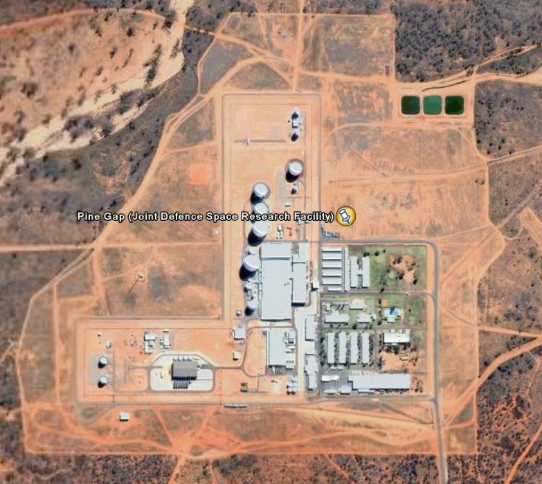 Pie Gap - Northern Territory - SIGINT & Satellite Relay "CIA, NSA & ASD"
 Geraldton - Western Australia - SIGINT "ASD"
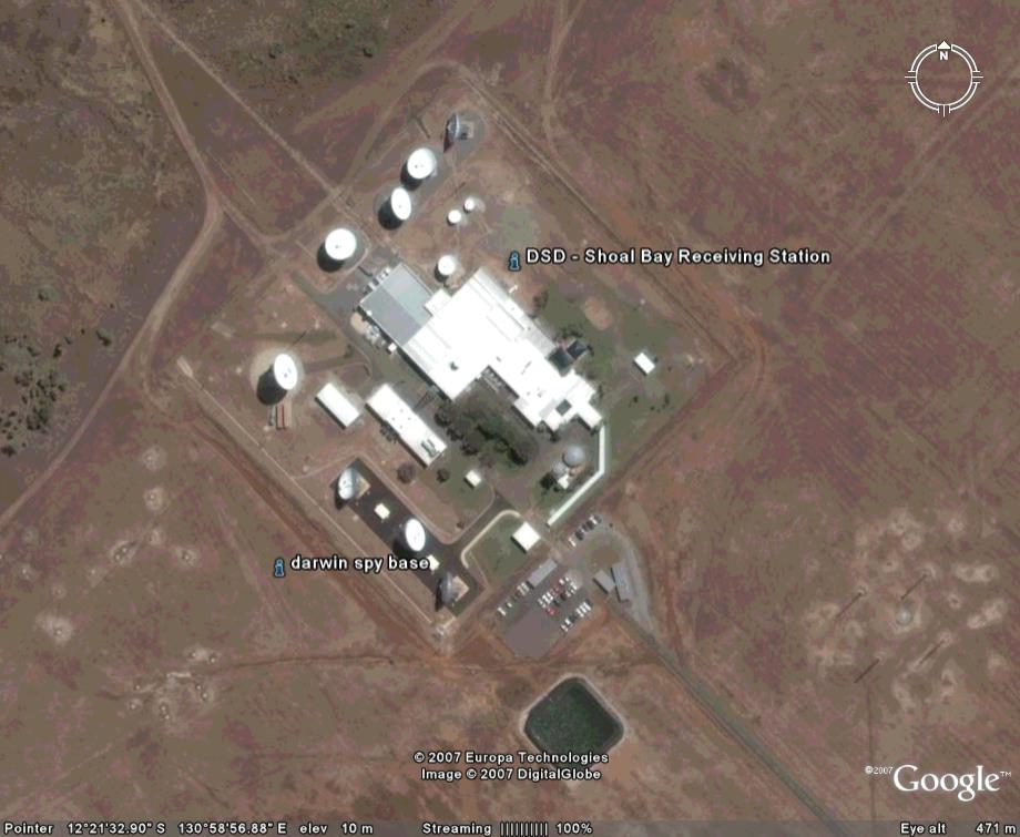 Shoal Bay - Northern Territory - SIGINT "ASD"
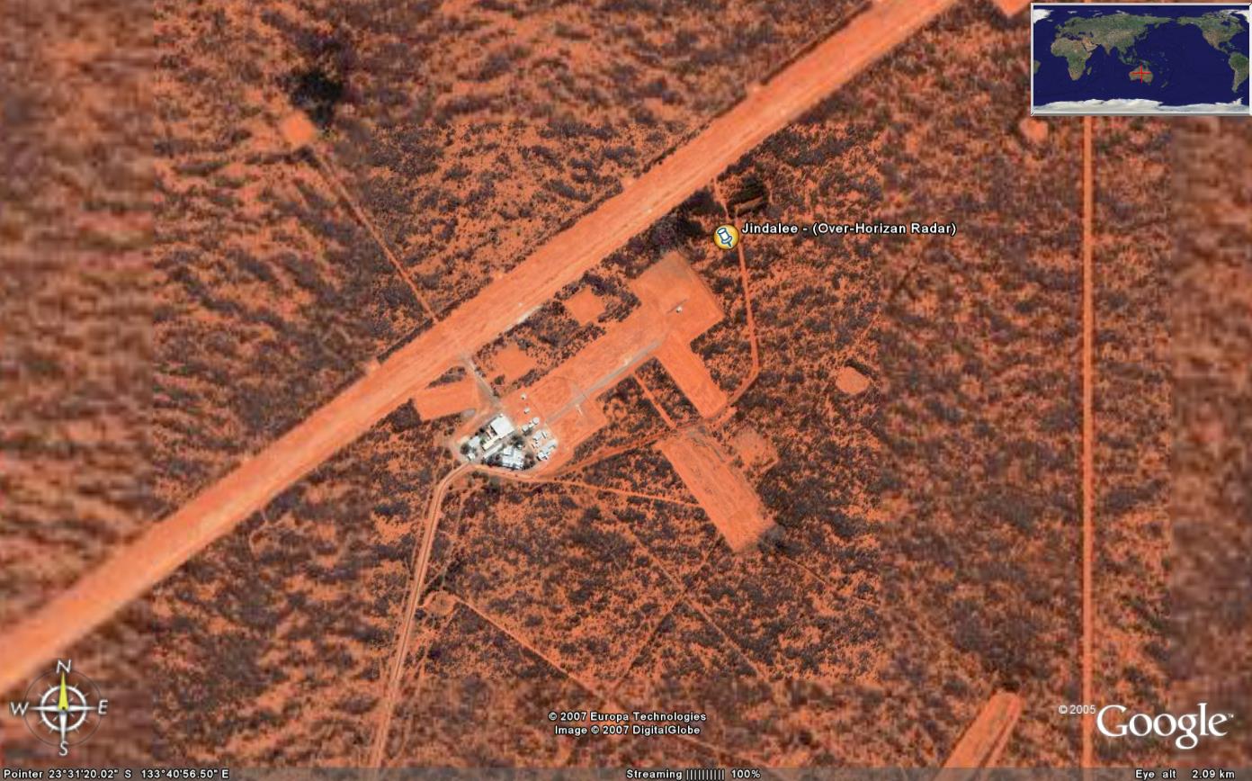 Jindalee Over Horizon Radar - Northern Territory - Radar "DoD RAAF"
 Jindalee Control Centre - South Australia - "RAAF Edinburgh"
 Harold Holt Control - Western Australia - "USN & RAN"
 Harold Holt Antenna - Western Australia - Communications "USN & RAN"
edit on 1122015 by AUSTEOReClassified because: re-edit
edit on 1122015 by AUSTEOReClassified because: re-edit
There have been strange lights being seen in the Darling Downs area near the Army Aviation base at Oakey.I know Google was doing drone testing there
last year.
a reply to: EA006
I can tell you exactly what it is: Interesting.
With that i promise i'll only comment again if i find something constructive to add.
Found this

"near" by. Could be a deserted water reservoir or something. Maybe they are both part of old infrastructure like that? Old water reservoirs, old villages, maybe...?
I can tell you exactly what it is: Interesting.
With that i promise i'll only comment again if i find something constructive to add.
Found this
"near" by. Could be a deserted water reservoir or something. Maybe they are both part of old infrastructure like that? Old water reservoirs, old villages, maybe...?
edit on -06:00America/ChicagoAmerica/ChicagopFridayAmerica/Chicago by Peeple because: add
new topics
-
Russian intelligence officer: explosions at defense factories in the USA and Wales may be sabotage
Weaponry: 48 minutes ago -
African "Newcomers" Tell NYC They Don't Like the Free Food or Shelter They've Been Given
Social Issues and Civil Unrest: 1 hours ago -
Russia Flooding
Other Current Events: 3 hours ago -
MULTIPLE SKYMASTER MESSAGES GOING OUT
World War Three: 3 hours ago -
Two Serious Crimes Committed by President JOE BIDEN that are Easy to Impeach Him For.
US Political Madness: 4 hours ago -
911 emergency lines are DOWN across multiple states
Breaking Alternative News: 4 hours ago -
Former NYT Reporter Attacks Scientists For Misleading Him Over COVID Lab-Leak Theory
Education and Media: 6 hours ago -
Why did Phizer team with nanobot maker
Medical Issues & Conspiracies: 7 hours ago -
Pro Hamas protesters at Columbia claim hit with chemical spray
World War Three: 7 hours ago -
Elites disapearing
Political Conspiracies: 9 hours ago
top topics
-
British TV Presenter Refuses To Use Guest's Preferred Pronouns
Education and Media: 17 hours ago, 17 flags -
Go Woke, Go Broke--Forbes Confirms Disney Has Lost Money On Star Wars
Movies: 11 hours ago, 13 flags -
Pro Hamas protesters at Columbia claim hit with chemical spray
World War Three: 7 hours ago, 11 flags -
Elites disapearing
Political Conspiracies: 9 hours ago, 8 flags -
Freddie Mercury
Paranormal Studies: 11 hours ago, 7 flags -
Nirvana - Immigrant Song
Music: 16 hours ago, 5 flags -
A Personal Cigar UFO/UAP Video footage I have held onto and will release it here and now.
Aliens and UFOs: 9 hours ago, 5 flags -
African "Newcomers" Tell NYC They Don't Like the Free Food or Shelter They've Been Given
Social Issues and Civil Unrest: 1 hours ago, 5 flags -
Two Serious Crimes Committed by President JOE BIDEN that are Easy to Impeach Him For.
US Political Madness: 4 hours ago, 5 flags -
Former NYT Reporter Attacks Scientists For Misleading Him Over COVID Lab-Leak Theory
Education and Media: 6 hours ago, 4 flags
active topics
-
Israel ufo shoot down drones?
Aliens and UFOs • 26 • : GENERAL EYES -
Russian intelligence officer: explosions at defense factories in the USA and Wales may be sabotage
Weaponry • 9 • : Lazy88 -
Why did Phizer team with nanobot maker
Medical Issues & Conspiracies • 5 • : daskakik -
African "Newcomers" Tell NYC They Don't Like the Free Food or Shelter They've Been Given
Social Issues and Civil Unrest • 4 • : GENERAL EYES -
The Acronym Game .. Pt.3
General Chit Chat • 7722 • : bally001 -
Two Serious Crimes Committed by President JOE BIDEN that are Easy to Impeach Him For.
US Political Madness • 7 • : Disgusted123 -
Russia Flooding
Other Current Events • 1 • : ksihkahe -
Running Through Idiot Protestors Who Block The Road
Rant • 107 • : FlyersFan -
Russia Ukraine Update Thread - part 3
World War Three • 5694 • : F2d5thCavv2 -
-@TH3WH17ERABB17- -Q- ---TIME TO SHOW THE WORLD--- -Part- --44--
Dissecting Disinformation • 518 • : Guyfriday