It looks like you're using an Ad Blocker.
Please white-list or disable AboveTopSecret.com in your ad-blocking tool.
Thank you.
Some features of ATS will be disabled while you continue to use an ad-blocker.

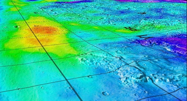
New Seafloor Maps Released ! Never Before Seen Mounts.
page: 122
share:
Looks like this would be perfect for google earth.
New Seafloor Maps Released ! Never Before Seen Mounts.
Cant seel to find it though. Anyway, looks like treasure hunters will know better where the older shore line is exactly. That should make this useful. I also have a feeling a better explanation of the Bermuda triangle is on this new map... what do you guys think about this? www.sciencerecorder.com...
a reply to: tonycodes
I have been waiting for this for a long time, can't wait to study it.
All i can find right now is pictures and info, i don't think the map itself is fully released for the public.
More info and pics beelow.
CLICK ME
Wait, i think i found it here.
CLICK ME 2
I have been waiting for this for a long time, can't wait to study it.
All i can find right now is pictures and info, i don't think the map itself is fully released for the public.
More info and pics beelow.
CLICK ME
Wait, i think i found it here.
CLICK ME 2
edit on 3-10-2014 by Mianeye because: (no reason given)
a reply to: tonycodes
Instead of climbing the highest mountains in the Rockies or Himalayas, adventurers can now put on their scuba gear and climb up (or down) the highest mountains in the ocean (it's all one ocean, with various named areas). Instead of mountain goats they're find mountain squid.
Instead of climbing the highest mountains in the Rockies or Himalayas, adventurers can now put on their scuba gear and climb up (or down) the highest mountains in the ocean (it's all one ocean, with various named areas). Instead of mountain goats they're find mountain squid.
The gravity mapping of the seafloor is interesting. However, for my point of view, a topographic map would have been a better article to read.
Cool, thanks for posting!
While searching for more about this, I also found this article:
Mapping the ocean floor: Satellite data reveals uncharted mountains buried a mile beneath the sea bed
While searching for more about this, I also found this article:
Mapping the ocean floor: Satellite data reveals uncharted mountains buried a mile beneath the sea bed
a reply to: tonycodes
Love stories like this one! We are sending humans to settle on Mars in the next few years, yet we don't even know everything that's under our oceans. 90% of what's under water is still unmapped, 90%!
From the OP source:
So crazy! Thousands of extinct volcanos, thousands of meters tall! Mind blowing!
SnF!
Love stories like this one! We are sending humans to settle on Mars in the next few years, yet we don't even know everything that's under our oceans. 90% of what's under water is still unmapped, 90%!
From the OP source:
The ocean floor is one of the most mysterious, least explored places on planet Earth. Nearly 90 percent of it still unmapped.
New ocean floor data reveals previously hidden mountains and volcanoes.
Using data from satellites that measure variations in Earth’s gravitational field, the researchers found a new, more accurate way to map the ocean floor.
They were able to identify a variety of previously unknown features—including thousands of extinct volcanoes more than 1000 meters tall.
So crazy! Thousands of extinct volcanos, thousands of meters tall! Mind blowing!
SnF!
Been thinking about this thread today,and I pondered how this technology may evolve in the future-today we see geological features,amazing enough.
But,maybe in some future tomorrow we will see remanants of ancient cities and sunken planes/ships-there are many down there.
But,maybe in some future tomorrow we will see remanants of ancient cities and sunken planes/ships-there are many down there.
a reply to: dreamingawake
Awesome.. thank you.. heres the link directly to the google earth overlays.. cant wait to see the anomolies ats pulls up.. lets try to fill this thread with some.. ill sure be looking for odities topex.ucsd.edu...
Awesome.. thank you.. heres the link directly to the google earth overlays.. cant wait to see the anomolies ats pulls up.. lets try to fill this thread with some.. ill sure be looking for odities topex.ucsd.edu...
edit on 3-10-2014 by tonycodes because: lonk
originally posted by: Ceeker63
The gravity mapping of the seafloor is interesting. However, for my point of view, a topographic map would have been a better article to read.
To do a topographic map, they would have to scan every single square meter of the ocean floor using seismographic and sonar methods. The gravity mapping is a relatively quick and easy way using a couple of satellites. But I am sure they will be able to improve the resolution by using multiple passes.
Scientists do something similar in astronomy by taking multiple images of an object and then combining them together. The slight differences in image position of each frame allow for a higher resolution to be generated.
These are awesome, i can not wait to see more. We know do little about our ocean.
new topics
-
Is the origin for the Eye of Horus the pineal gland?
General Conspiracies: 18 minutes ago -
Man sets himself on fire outside Donald Trump trial
Mainstream News: 29 minutes ago -
Biden says little kids flip him the bird all the time.
2024 Elections: 35 minutes ago -
The Democrats Take Control the House - Look what happened while you were sleeping
US Political Madness: 1 hours ago -
Sheetz facing racial discrimination lawsuit for considering criminal history in hiring
Social Issues and Civil Unrest: 1 hours ago -
In an Historic First, In N Out Burger Permanently Closes a Location
Mainstream News: 3 hours ago -
MH370 Again....
Disaster Conspiracies: 3 hours ago -
Are you ready for the return of Jesus Christ? Have you been cleansed by His blood?
Religion, Faith, And Theology: 5 hours ago -
Chronological time line of open source information
History: 7 hours ago -
A man of the people
Diseases and Pandemics: 8 hours ago
top topics
-
Israeli Missile Strikes in Iran, Explosions in Syria + Iraq
World War Three: 17 hours ago, 18 flags -
In an Historic First, In N Out Burger Permanently Closes a Location
Mainstream News: 3 hours ago, 14 flags -
Thousands Of Young Ukrainian Men Trying To Flee The Country To Avoid Conscription And The War
Other Current Events: 13 hours ago, 7 flags -
The Democrats Take Control the House - Look what happened while you were sleeping
US Political Madness: 1 hours ago, 7 flags -
Iran launches Retalliation Strike 4.18.24
World War Three: 16 hours ago, 6 flags -
12 jurors selected in Trump criminal trial
US Political Madness: 16 hours ago, 4 flags -
4 plans of US elites to defeat Russia
New World Order: 10 hours ago, 4 flags -
A man of the people
Diseases and Pandemics: 8 hours ago, 4 flags -
Sheetz facing racial discrimination lawsuit for considering criminal history in hiring
Social Issues and Civil Unrest: 1 hours ago, 2 flags -
Biden says little kids flip him the bird all the time.
2024 Elections: 35 minutes ago, 2 flags
active topics
-
12 jurors selected in Trump criminal trial
US Political Madness • 68 • : Annee -
Man sets himself on fire outside Donald Trump trial
Mainstream News • 3 • : ManSizedSquirrel -
"We're All Hamas" Heard at Columbia University Protests
Social Issues and Civil Unrest • 131 • : marg6043 -
Biden says little kids flip him the bird all the time.
2024 Elections • 3 • : SideEyeEverything1 -
So I saw about 30 UFOs in formation last night.
Aliens and UFOs • 35 • : charlyv -
The Democrats Take Control the House - Look what happened while you were sleeping
US Political Madness • 13 • : WiiDemBoyz -
Israeli Missile Strikes in Iran, Explosions in Syria + Iraq
World War Three • 97 • : DBCowboy -
Sheetz facing racial discrimination lawsuit for considering criminal history in hiring
Social Issues and Civil Unrest • 5 • : Shoshanna -
Is the origin for the Eye of Horus the pineal gland?
General Conspiracies • 0 • : JoelSnape -
MH370 Again....
Disaster Conspiracies • 7 • : billxam1
22