It looks like you're using an Ad Blocker.
Please white-list or disable AboveTopSecret.com in your ad-blocking tool.
Thank you.
Some features of ATS will be disabled while you continue to use an ad-blocker.

Did Marco Polo "Discover" America?
page: 1share:
Okay this story is rather odd. So I will let the article speak for itself.
Marco ?
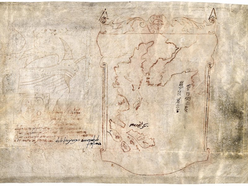
Maps attributed to the 13th-century traveler sketch what looks like the coast of Alaska
Enjoy
Obviously various group tens of thousands of years ago first walked onto land we call the Americas. The Inuit use to discover Asia and the America every week for thousands of years. So all those folks were well ahead of the Norse and Columbus.....but Marco Polo?
hmmmm
Marco ?
Maps attributed to the 13th-century traveler sketch what looks like the coast of Alaska
Enjoy
Obviously various group tens of thousands of years ago first walked onto land we call the Americas. The Inuit use to discover Asia and the America every week for thousands of years. So all those folks were well ahead of the Norse and Columbus.....but Marco Polo?
hmmmm
edit on 27/9/14 by Hanslune because: (no reason given)
a reply to: Hanslune
I think the Vikings did but then again you can't discover something if people are already there(native Americans). I'd like to know where they first migrated here from.
As a sailor he probably collected them in case he ever needed it like the article alludes to.
Polo!
I think the Vikings did but then again you can't discover something if people are already there(native Americans). I'd like to know where they first migrated here from.
As a sailor he probably collected them in case he ever needed it like the article alludes to.
Polo!
edit on 9/27/2014 by AnteBellum because: (no reason given)
Has the authenticity of Marco Polo's second hand stories been established?
I think the Indians discovered America. The Spanish people just claimed it in 1492. The English tried claiming it a hundred years later using
information from records of their colonies trips there a lot earlier than 1492 The fact that some of the Indians had spoke an evolved old Norse for
generations was found when the English had settled a colony on the east coast verified these records. I don't think that it was just a coincidence
that the old Norse language evolved on two seperate continents with no . The English filed a claim to America about a hundred years later using
this evidence of a much earlier discovery. This was a legit claim, but it never made it into our history books. Our records said Columbus discovered
America for some strange reasons.
Now, Marco Polo's claim was also later than the English claim I think. Now, Norway was under English colonization around sixteen hundred but were just allied to England around the twelve hundreds. England did claim half or more of the USA and Canada using this evidence long ago.
Boy, I am tired, I have been listening to stuff about early history in America for two days, including the templers being here in 1292. There are a lot of records to validate all this stuff in the English and masonic records that are being uncovered lately.
Intriguing, yes? The question yet to be settled is are they authentic 13th C. maps, later copies, or outright fakes? Polo may have conjured up such a
map based on tales of sea-faring fishermen even if he never ventured so far eastward to see the coast himself.
I used to believe in that timeline of events. Then I did some research on the Tribe of Dan and the Phoenicians.
From out of the sea, to the bottomless abyss
From our world, to that which lies beyond
If money is the root of all evil, then what lies just out of reach?
From out of the sea, to the bottomless abyss
From our world, to that which lies beyond
If money is the root of all evil, then what lies just out of reach?
I'd say it was the Chinese Marco Polo just went along for the ride .
a reply to: Hanslune
Hans,
Holy f'in moley,
What is the context of that map? Is it from MP's writings? I doubt MP made that journey, but could be have copied a chinese map?
I'd say that is absolutely a map of the bearing straights and surrounding lands.
Pretty cool sir, either way.
Hans,
Holy f'in moley,
What is the context of that map? Is it from MP's writings? I doubt MP made that journey, but could be have copied a chinese map?
I'd say that is absolutely a map of the bearing straights and surrounding lands.
Pretty cool sir, either way.
a reply to: punkinworks10
Yeah I agree man, I reckon he heard stories of it from the Chinese, perhaps even drew from one of their maps, I mean there is even Chinese writing to the side of it.
MARCO, that guy loved exploration I suppose it is possible he did see it for himself.
Cracking find non the less!
Peace
Yeah I agree man, I reckon he heard stories of it from the Chinese, perhaps even drew from one of their maps, I mean there is even Chinese writing to the side of it.
MARCO, that guy loved exploration I suppose it is possible he did see it for himself.
Cracking find non the less!
Peace
a reply to: Hanslune
Just read the link, sweet, as I have just become a member of the Smithsonian and should get that mag in a few days. Last months has good article on Kenewick man.
Well then, only time and more research will tell for sure.
P.S.
With regards to the Hiada thread, I hope I didn't come across as calling your knowledge into question, as I highly respect your opinion and input.
originally posted by: punkinworks10
a reply to: Hanslune
Just read the link, sweet, as I have just become a member of the Smithsonian and should get that mag in a few days. Last months has good article on Kenewick man.
Well then, only time and more research will tell for sure.
P.S.
With regards to the Hiada thread, I hope I didn't come across as calling your knowledge into question, as I highly respect your opinion and input.
Yes more research is necessary but I'm skeptical of the claim so will wait to be amazed. On Haida; feel free to call my knowledge into question at any time! I remain a perpetual student.
edit on 28/9/14 by Hanslune because: (no reason given)
originally posted by: Blackmarketeer
Intriguing, yes? The question yet to be settled is are they authentic 13th C. maps, later copies, or outright fakes? Polo may have conjured up such a map based on tales of sea-faring fishermen even if he never ventured so far eastward to see the coast himself.
That is the question. One thing I've notice about the map is that resembles a rough drawing of the upper Aegean sea. I wonder if someone could have made it appear like the area in question by adding some islands and script.
However, that is extremely speculative speculation.
I don't know how reliable the source is, but I've seen a documentary which suggests Marco Polo's travels were largely if not entirely
fictitious.
Even if the story were true though, Marco Polo didn't write a book that is known to exist - he allegedly dictated the story to a fiction writer in prison. Therefore he could not possibly have drawn an accurate map himself unless it came from a previously unknown book written during his travels.
Assuming for the moment that this is a real map predating the known discovery of Alaska however, it is not that surprising that the Chinese might have been the discoverers, probably around the time of Zeng He's (spelling?) treasure fleet.
originally posted by: Blackmarketeer
Why don't they test all the maps??! How frustrating!
They could easily be later copies, as they seem (?) to show actual landmasses, by the account in the article.
S&F Hanslune, what a great article. I'm looking forward to the book release in November, it should be well worth a read.
Intriguing, yes? The question yet to be settled is are they authentic 13th C. maps, later copies, or outright fakes? Polo may have conjured up such a map based on tales of sea-faring fishermen even if he never ventured so far eastward to see the coast himself.
But as Olshin is first to admit, the authenticity of the ten maps and four texts is hardly settled. The ink remains untested, and a radiocarbon study of the parchment of one key map—the only one subjected to such analysis—dates the sheepskin vellum to the 15th or 16th century, a sign the map is at best a copy. Another quandary is that Polo himself wrote nothing of personal maps or of lands beyond Asia, though he did once boast: “I did not tell half of what I saw.”
Why don't they test all the maps??! How frustrating!
They could easily be later copies, as they seem (?) to show actual landmasses, by the account in the article.
S&F Hanslune, what a great article. I'm looking forward to the book release in November, it should be well worth a read.
a reply to: Hanslune
Hans,
It could be that the map was made by a different Italian, and in the ensuing years that the name of the actual author has been forgotten and Marco Polo's name associated with the papers to give "more"credibility.
Afterall, there were trade links between the Romans and the Chinese, enough trade that there was chinese quarter in some imperial era Roman port town. It wouldnt be a stretch to see a fair number of Italians keeping trade relations alive after the fall of the empire.
That being said, the map could be the Aegean, but the orientation of the island arc and the islands do bear a striking resemblance to Japan, the Philippines, and the Indonesian archipelago.
originally posted by: punkinworks10
a reply to: Hanslune
Hans,
It could be that the map was made by a different Italian, and in the ensuing years that the name of the actual author has been forgotten and Marco Polo's name associated with the papers to give "more"credibility.
Afterall, there were trade links between the Romans and the Chinese, enough trade that there was chinese quarter in some imperial era Roman port town. It wouldnt be a stretch to see a fair number of Italians keeping trade relations alive after the fall of the empire.
That being said, the map could be the Aegean, but the orientation of the island arc and the islands do bear a striking resemblance to Japan, the Philippines, and the Indonesian archipelago.
They certainly do but are they original? It all depends on whether the maps are the true deal. I suspect that no information will be forth coming until the book comes out and even then I suspect the investigation of the maps will be delayed for some time.
Yes the Roman trade port of Arikamedu which I visited years ago.
originally posted by: The Vagabond
I don't know how reliable the source is, but I've seen a documentary which suggests Marco Polo's travels were largely if not entirely fictitious.
Even if the story were true though, Marco Polo didn't write a book that is known to exist - he allegedly dictated the story to a fiction writer in prison. Therefore he could not possibly have drawn an accurate map himself unless it came from a previously unknown book written during his travels.
Assuming for the moment that this is a real map predating the known discovery of Alaska however, it is not that surprising that the Chinese might have been the discoverers, probably around the time of Zeng He's (spelling?) treasure fleet.
There is some good evidence that MP may not have made the journey he said, he may have done a well known time honored method of travel book writing, just reporting other travelers tales.
new topics
-
Las Vegas UFO Spotting Teen Traumatized by Demon Creature in Backyard
Aliens and UFOs: 18 minutes ago -
2024 Pigeon Forge Rod Run - On the Strip (Video made for you)
Automotive Discussion: 1 hours ago -
Gaza Terrorists Attack US Humanitarian Pier During Construction
Middle East Issues: 1 hours ago -
The functionality of boldening and italics is clunky and no post char limit warning?
ATS Freshman's Forum: 2 hours ago -
Meadows, Giuliani Among 11 Indicted in Arizona in Latest 2020 Election Subversion Case
Mainstream News: 3 hours ago -
Massachusetts Drag Queen Leads Young Kids in Free Palestine Chant
Social Issues and Civil Unrest: 3 hours ago -
Weinstein's conviction overturned
Mainstream News: 4 hours ago -
Supreme Court Oral Arguments 4.25.2024 - Are PRESIDENTS IMMUNE From Later Being Prosecuted.
Above Politics: 6 hours ago -
Krystalnacht on today's most elite Universities?
Social Issues and Civil Unrest: 6 hours ago -
Chris Christie Wishes Death Upon Trump and Ramaswamy
Politicians & People: 6 hours ago
top topics
-
Krystalnacht on today's most elite Universities?
Social Issues and Civil Unrest: 6 hours ago, 8 flags -
Weinstein's conviction overturned
Mainstream News: 4 hours ago, 6 flags -
Supreme Court Oral Arguments 4.25.2024 - Are PRESIDENTS IMMUNE From Later Being Prosecuted.
Above Politics: 6 hours ago, 5 flags -
University of Texas Instantly Shuts Down Anti Israel Protests
Education and Media: 9 hours ago, 5 flags -
Massachusetts Drag Queen Leads Young Kids in Free Palestine Chant
Social Issues and Civil Unrest: 3 hours ago, 4 flags -
Meadows, Giuliani Among 11 Indicted in Arizona in Latest 2020 Election Subversion Case
Mainstream News: 3 hours ago, 4 flags -
Chris Christie Wishes Death Upon Trump and Ramaswamy
Politicians & People: 6 hours ago, 2 flags -
Any one suspicious of fever promotions events, major investor Goldman Sachs card only.
The Gray Area: 11 hours ago, 2 flags -
Gaza Terrorists Attack US Humanitarian Pier During Construction
Middle East Issues: 1 hours ago, 2 flags -
2024 Pigeon Forge Rod Run - On the Strip (Video made for you)
Automotive Discussion: 1 hours ago, 1 flags
active topics
-
Gaza Terrorists Attack US Humanitarian Pier During Construction
Middle East Issues • 16 • : Consvoli -
University of Texas Instantly Shuts Down Anti Israel Protests
Education and Media • 186 • : DBCowboy -
Sunak spinning the sickness figures
Other Current Events • 20 • : xWorldxGonexMadx -
Candidate TRUMP Now Has Crazy Judge JUAN MERCHAN After Him - The Stormy Daniels Hush-Money Case.
Political Conspiracies • 782 • : Vermilion -
Las Vegas UFO Spotting Teen Traumatized by Demon Creature in Backyard
Aliens and UFOs • 1 • : chiefsmom -
God's Righteousness is Greater than Our Wrath
Religion, Faith, And Theology • 30 • : confuzedcitizen -
Chris Christie Wishes Death Upon Trump and Ramaswamy
Politicians & People • 19 • : DontTreadOnMe -
Supreme Court Oral Arguments 4.25.2024 - Are PRESIDENTS IMMUNE From Later Being Prosecuted.
Above Politics • 60 • : Annee -
Breaking Baltimore, ship brings down bridge, mass casualties
Other Current Events • 489 • : Threadbarer -
-@TH3WH17ERABB17- -Q- ---TIME TO SHOW THE WORLD--- -Part- --44--
Dissecting Disinformation • 679 • : McTech2