It looks like you're using an Ad Blocker.
Please white-list or disable AboveTopSecret.com in your ad-blocking tool.
Thank you.
Some features of ATS will be disabled while you continue to use an ad-blocker.

Lesser Known Mysteries IV: Strange Seas
page: 120
share:
In this, the fourth installment of my Lesser Known Mysteries series, I present a pair of lesser known maritime mysteries. Though these events
took place thousands of miles and decades apart, there are elements common to both that I felt made for a worthwhile pairing.
Bouvet Island Lifeboat
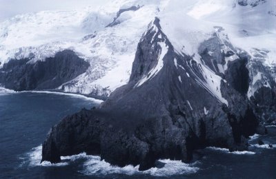 Bouvet Island, the opposite of an island paradise.
Bouvet Island is the most remote island in the world. From Wikipedia (my emphasis):
Initially discovered in 1739 by Jean-Baptiste Charles Bouvet de Lozier, commander of the French ships Aigle and Marie, it was believed to be not an island, but the northern cape of the hypothesized continent, Terra Australis and its location was inaccurately recorded. Various expeditions attempted to locate the island afterward, but even the efforts of the legendary Captain James Cook failed to find it. It wasn't discovered again until 1808 by a British whaler, James Lindsay, captain of the ship Snow Swan, who being a quite modest man, named it Lindsay Island. The next alleged visit was by an American, Benjamin Morrell, a seal hunter and captain of the Wasp who claimed to have hunted 196 seals on the island but whether or not he actually visited the island is disputed as his description contains no mention of its permanent ice cover.
In 1825, the island was next visited by British sealer George Norris, with his ships the Sprightly and Lively. A nearby reef, Norris Reef is named for him. In voyages in 1843 and 1845, even the famed explorer James Ross was unable locate Bouvet Island. It wasn't until 1898, when the German survey ship Valdivia, captained by Kapitan Krech and part of an expedition led by Karl Chun, reached the island that the proper coordinates were fixed on navigation maps. The history of Bouvet island is one of controversial land claims and a fair share of mystery — including an associated phantom island, Thompson Island, which was reportedly found some 45 miles away by George Norris!
However, for our purposes, it suffices to say that it is the most remote tract of land in all of the ocean and a very inhospital one at that — which might explain why the UK dropped their potests to the 1928 annexation of the island by Norway (few people seem less bothered by icy, inhospitable conditions than Norwegians!). The Norwegians erected a hut and a flagpole in 1929 at Kapp Circoncision, a small rocky peninsula named for The Feast of the Circumcision. The island was next visited in 1955 by the South African frigate Transvaal. Sometime after this visit and before 1958, the largest ice-free area on the island, Nyrøysa (Norwegian for "New Rubble"), was created by a landslide (maybe.. if a landslide occurs on the remotest island in the world and nobody sees it, did it make a beach?).
And here, on this teenie-tiny, rock-strewn patch of desolation, on the most remote island in the world, Allan Crawford, captain of the HMS Protector landed in a helicopter on April 2nd, 1964 and discovered a 20-foot life boat and other signs of human occupation. From his account:
What drama, we wondered, was attached to this strange discovery. There were no markings to identify its origin or nationality. On the rocks a hundred yards away was a forty-four gallon drum and a pair of oars, with pieces of wood and a copper flotation or buoyancy tank opened out flat for some purpose. Thinking castaways might have landed, we made a brief search but found no human remains.
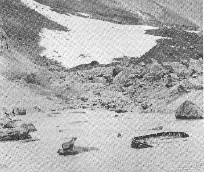 The mysterious Bouvet Island Lifeboat
How had the boat come to be there a thousand miles or more from the nearest shipping lane? What had become of the man or men who had rowed it? Where they castaways? Survivors of a sunken whaling ship? With no other shelter in sight, why was the boat drug up into the lagoon but not out of the water? Clearly to hammer flat the copper tank, somebody was preparing to be there for some amount of time. We are left with only questions — questions unlikely to ever have answers. When the island was next visited by a biological expedition 2 years later, there was no mention made of the boat or the objects found in 1964. There is an excellent post by author and historian Mike Dash, with loads of additional background and some hypotheses at his blog: A Blast from the Past - An abandoned lifeboat at world’s end.
Bouvet Island Lifeboat
Bouvet Island is the most remote island in the world. From Wikipedia (my emphasis):
Bouvet Island (Norwegian: Bouvetøya,[1] previously spelled Bouvet-øya[2]) is an uninhabited subantarctic volcanic island and dependency of Norway located in the South Atlantic Ocean at 54°25.8'S 3°22.8'. It lies at the southern end of the Mid-Atlantic Ridge and is the most remote island in the world, approximately 2,200 kilometres (1,400 mi) south-southwest of the coast of South Africa and approximately 1,700 kilometres (1,100 mi) north of the Princess Astrid Coast of Queen Maud Land, Antarctica.
The island has an area of 49 square kilometres (19 sq mi), of which 93 percent is covered by a glacier. The centre of the island is an ice-filled crater of an inactive volcano. Some skerries and one smaller island, Larsøya, lie along the coast. Nyrøysa, created by a rock slide in the late 1950s, is the only easy place to land and is the location of a weather station.
Initially discovered in 1739 by Jean-Baptiste Charles Bouvet de Lozier, commander of the French ships Aigle and Marie, it was believed to be not an island, but the northern cape of the hypothesized continent, Terra Australis and its location was inaccurately recorded. Various expeditions attempted to locate the island afterward, but even the efforts of the legendary Captain James Cook failed to find it. It wasn't discovered again until 1808 by a British whaler, James Lindsay, captain of the ship Snow Swan, who being a quite modest man, named it Lindsay Island. The next alleged visit was by an American, Benjamin Morrell, a seal hunter and captain of the Wasp who claimed to have hunted 196 seals on the island but whether or not he actually visited the island is disputed as his description contains no mention of its permanent ice cover.
In 1825, the island was next visited by British sealer George Norris, with his ships the Sprightly and Lively. A nearby reef, Norris Reef is named for him. In voyages in 1843 and 1845, even the famed explorer James Ross was unable locate Bouvet Island. It wasn't until 1898, when the German survey ship Valdivia, captained by Kapitan Krech and part of an expedition led by Karl Chun, reached the island that the proper coordinates were fixed on navigation maps. The history of Bouvet island is one of controversial land claims and a fair share of mystery — including an associated phantom island, Thompson Island, which was reportedly found some 45 miles away by George Norris!
However, for our purposes, it suffices to say that it is the most remote tract of land in all of the ocean and a very inhospital one at that — which might explain why the UK dropped their potests to the 1928 annexation of the island by Norway (few people seem less bothered by icy, inhospitable conditions than Norwegians!). The Norwegians erected a hut and a flagpole in 1929 at Kapp Circoncision, a small rocky peninsula named for The Feast of the Circumcision. The island was next visited in 1955 by the South African frigate Transvaal. Sometime after this visit and before 1958, the largest ice-free area on the island, Nyrøysa (Norwegian for "New Rubble"), was created by a landslide (maybe.. if a landslide occurs on the remotest island in the world and nobody sees it, did it make a beach?).
And here, on this teenie-tiny, rock-strewn patch of desolation, on the most remote island in the world, Allan Crawford, captain of the HMS Protector landed in a helicopter on April 2nd, 1964 and discovered a 20-foot life boat and other signs of human occupation. From his account:
What drama, we wondered, was attached to this strange discovery. There were no markings to identify its origin or nationality. On the rocks a hundred yards away was a forty-four gallon drum and a pair of oars, with pieces of wood and a copper flotation or buoyancy tank opened out flat for some purpose. Thinking castaways might have landed, we made a brief search but found no human remains.
How had the boat come to be there a thousand miles or more from the nearest shipping lane? What had become of the man or men who had rowed it? Where they castaways? Survivors of a sunken whaling ship? With no other shelter in sight, why was the boat drug up into the lagoon but not out of the water? Clearly to hammer flat the copper tank, somebody was preparing to be there for some amount of time. We are left with only questions — questions unlikely to ever have answers. When the island was next visited by a biological expedition 2 years later, there was no mention made of the boat or the objects found in 1964. There is an excellent post by author and historian Mike Dash, with loads of additional background and some hypotheses at his blog: A Blast from the Past - An abandoned lifeboat at world’s end.
edit on 2014-9-15 by theantediluvian because: (no reason given)
The Sarah Joe
 The Sarah Joe
On February 11, 1979 five friends left from Hana Bay, on the Hawaiian island of Maui, in a 17-foot Boston Whaler, the Sarah Joe. The five were taking a day off from building the home of one of the men, Ralph Malaiakini, and were headed out for a day of fishing on Ralph's twin brother's boat. The friends were all locals: Benjamin Kalam, 38, was a tile setter and father of five, Peter Hanchett, 31 and a plumber, Patrick Woessner, 26 and Scott Moorman, 27, both carpenters and Ralph Malaiakini, 27, who owned a trucking business.
Around 10:00 AM when the men left, the seas were calm and the weather fair but by late afternoon a gale was rising and the seas were quickly becoming rough. Within hours, the wife of one of the men called the Coast Guard and local fisherman, including Ralph's twin brother Robert, went out in a storm searching for the men in seas that were among the roughest they'd ever encountered, with 40-foot swells and visibility measured in inches. The Coast Guard searched for the men for four days and their families, friends and volunteers searched for a month but it was all to no avail.
It was assumed that the ship was lost in the storm and the men had perished at sea and for nine and a half years there were no further developments. Then, on September 10, 1988, marine biologist John Naughton and four other scientist went ashore on Sibylla Island to look for sea turtled and bird nests and discovered a battered fiberglass boat hull, partially buried in the sand. If Sibylla doesn't sound like a Hawaiian name to you, that's because it's not — it's an island in the uninhabited Bokak (aka Taongi) Atoll, the most isolated and northermost atoll in the Marshall Islands — well over 2,000 miles from Hawaii. As you've by now surely guessed, the boat was the wreckage of the ill-fated Sarah Joe and as fate would have it, John Naughton was from Hawaii and had actually participated in the search for the missing men years earlier. While it is a considerable distance for the boat to have travelled, these things do occur as was amply evidenced by the debris from the 2011 Japanese tsunami found along the US West Coast. However, the story does not end here.
John Naughton led a search of the island and soon after, a crude wooden cross was discovered marking a shallow grave about a hundred yards from the wrecked boat. Excerpted from Writer's Beat:
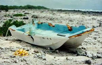 The wreckage of the Sarah Joe
John Naughton contacted Marshallese authorities who it seems did not relay the information to US officials. It wasn't until John Naughton contacted the US Coast Guard in Hawaii that a ship bearing forensic experts was dispatched to recover the remains and the wreckage. The remains were later identified with dental x-rays as those of Scott Moorman. A cause of death could not be established. No trace of the other four men was ever discovered.
Additional sources & resources:
Article from the Star Bulletin on the 30th anniversay of the disappearance (2009)
Hawaii Stories - Phantoms, non-fiction by Bill Moake, a Hana-area resident (2004)
If you enjoyed this thread, you may also be interested in the first three installments of my ongoing series, Lesser Known Mysteries: Mysterious People, Enigmatic Inscriptions and Unexplained Artifacts.
On February 11, 1979 five friends left from Hana Bay, on the Hawaiian island of Maui, in a 17-foot Boston Whaler, the Sarah Joe. The five were taking a day off from building the home of one of the men, Ralph Malaiakini, and were headed out for a day of fishing on Ralph's twin brother's boat. The friends were all locals: Benjamin Kalam, 38, was a tile setter and father of five, Peter Hanchett, 31 and a plumber, Patrick Woessner, 26 and Scott Moorman, 27, both carpenters and Ralph Malaiakini, 27, who owned a trucking business.
Around 10:00 AM when the men left, the seas were calm and the weather fair but by late afternoon a gale was rising and the seas were quickly becoming rough. Within hours, the wife of one of the men called the Coast Guard and local fisherman, including Ralph's twin brother Robert, went out in a storm searching for the men in seas that were among the roughest they'd ever encountered, with 40-foot swells and visibility measured in inches. The Coast Guard searched for the men for four days and their families, friends and volunteers searched for a month but it was all to no avail.
It was assumed that the ship was lost in the storm and the men had perished at sea and for nine and a half years there were no further developments. Then, on September 10, 1988, marine biologist John Naughton and four other scientist went ashore on Sibylla Island to look for sea turtled and bird nests and discovered a battered fiberglass boat hull, partially buried in the sand. If Sibylla doesn't sound like a Hawaiian name to you, that's because it's not — it's an island in the uninhabited Bokak (aka Taongi) Atoll, the most isolated and northermost atoll in the Marshall Islands — well over 2,000 miles from Hawaii. As you've by now surely guessed, the boat was the wreckage of the ill-fated Sarah Joe and as fate would have it, John Naughton was from Hawaii and had actually participated in the search for the missing men years earlier. While it is a considerable distance for the boat to have travelled, these things do occur as was amply evidenced by the debris from the 2011 Japanese tsunami found along the US West Coast. However, the story does not end here.
John Naughton led a search of the island and soon after, a crude wooden cross was discovered marking a shallow grave about a hundred yards from the wrecked boat. Excerpted from Writer's Beat:
“There was a cairn or pile of flattened coral shingles and toward the top of it was a human mandible,” said Charles Streck, a civilian archaeologist with the U.S. Army Corps of Engineers. Aside from the lower jaw bone, the top portion of the grave contained a sheaf of papers that appeared to have been burned.
“We didn’t dig up the grave,” Naughton said. “We could see it was a Christian burial and the Marshallese with us were somewhat superstitious. We immediately saw there were fillings in the teeth. And we could see it was not a very old burial just by the fact that the bones were not very bleached.” Streck concurred that the grave appeared to be fairly recent. “It was in an area that had been washed by really high storm waves sometime in the recent past,” he said.
Naughton also found some meaningful floatsam on the ocean side of the island. Litter from Hawaii-pieces of styrofoam beer coolers, glass balls and other debris-had been washing ashore for a very long time. The island was directly downstream in the southwest current that had obviously carried the Sarah Joe from Hawaii.
John Naughton contacted Marshallese authorities who it seems did not relay the information to US officials. It wasn't until John Naughton contacted the US Coast Guard in Hawaii that a ship bearing forensic experts was dispatched to recover the remains and the wreckage. The remains were later identified with dental x-rays as those of Scott Moorman. A cause of death could not be established. No trace of the other four men was ever discovered.
Additional sources & resources:
Article from the Star Bulletin on the 30th anniversay of the disappearance (2009)
Hawaii Stories - Phantoms, non-fiction by Bill Moake, a Hana-area resident (2004)
If you enjoyed this thread, you may also be interested in the first three installments of my ongoing series, Lesser Known Mysteries: Mysterious People, Enigmatic Inscriptions and Unexplained Artifacts.
edit on 2014-9-15 by theantediluvian because: (no
reason given)
a reply to: theantediluvian
I remember that story about the guys who disappeared and the boat was found and the skull....remember the unsolved m ysteries story...thanks for posting this...took me back
I remember that story about the guys who disappeared and the boat was found and the skull....remember the unsolved m ysteries story...thanks for posting this...took me back
Oh man, now my mother's fear of boats makes a lot more sense! I don't want to go on a boat for a while now I think.
Imagine being lost at sea, then suddenly... LAND! Oh yes, sweet Jesus its... just the most remote barren frozen island in the world...
That show Unsolved Mysteries used to scare the crap outta me when I was a kid! But I was addicted to it... kinda like ATS.
Imagine being lost at sea, then suddenly... LAND! Oh yes, sweet Jesus its... just the most remote barren frozen island in the world...
That show Unsolved Mysteries used to scare the crap outta me when I was a kid! But I was addicted to it... kinda like ATS.
I think it might be a little more obvious... I dont think it would have to take place in that time window. It simply had to move there in that time
period, but it moved there roughly intact.
It mentioned the Norwegians
It's very possible they left a boat along with the supplies. In Orkney especially people would make temporary shelters out of rock, and for roof they would upturn boats. This is also a reason ancient ruins do not have roofs.
The supplies were destroyed and who knows if things went elsewhere. It would also explain why they only left a few things, one boat, 2 oars - they just wanted to leave a bare minimum. The copper might have been flattened out for cooking or for reflective surface - after all, how could you signal any possible passing ships?
We have an old saying - the more inhospitable the place, the more hospitable the people.
It mentioned the Norwegians
left a small cache of provisions on shore for the benefit of any shipwrecked mariners. [Baker pp.72-3] The Norwegians returned in 1929 and again a few years later (when it was discovered that both their supply huts had been destroyed by the unremittingly hostile local weather),
It's very possible they left a boat along with the supplies. In Orkney especially people would make temporary shelters out of rock, and for roof they would upturn boats. This is also a reason ancient ruins do not have roofs.
The supplies were destroyed and who knows if things went elsewhere. It would also explain why they only left a few things, one boat, 2 oars - they just wanted to leave a bare minimum. The copper might have been flattened out for cooking or for reflective surface - after all, how could you signal any possible passing ships?
We have an old saying - the more inhospitable the place, the more hospitable the people.
new topics
-
Supreme Court Oral Arguments 4.25.2024 - Are PRESIDENTS IMMUNE From Later Being Prosecuted.
Above Politics: 26 minutes ago -
Krystalnacht on today's most elite Universities?
Social Issues and Civil Unrest: 35 minutes ago -
Chris Christie Wishes Death Upon Trump and Ramaswamy
Politicians & People: 1 hours ago -
University of Texas Instantly Shuts Down Anti Israel Protests
Education and Media: 3 hours ago -
Any one suspicious of fever promotions events, major investor Goldman Sachs card only.
The Gray Area: 5 hours ago -
God's Righteousness is Greater than Our Wrath
Religion, Faith, And Theology: 9 hours ago
top topics
-
VP's Secret Service agent brawls with other agents at Andrews
Mainstream News: 14 hours ago, 11 flags -
Nearly 70% Of Americans Want Talks To End War In Ukraine
Political Issues: 15 hours ago, 5 flags -
Sunak spinning the sickness figures
Other Current Events: 14 hours ago, 5 flags -
Electrical tricks for saving money
Education and Media: 12 hours ago, 4 flags -
Late Night with the Devil - a really good unusual modern horror film.
Movies: 16 hours ago, 3 flags -
Krystalnacht on today's most elite Universities?
Social Issues and Civil Unrest: 35 minutes ago, 3 flags -
Any one suspicious of fever promotions events, major investor Goldman Sachs card only.
The Gray Area: 5 hours ago, 2 flags -
University of Texas Instantly Shuts Down Anti Israel Protests
Education and Media: 3 hours ago, 2 flags -
Supreme Court Oral Arguments 4.25.2024 - Are PRESIDENTS IMMUNE From Later Being Prosecuted.
Above Politics: 26 minutes ago, 1 flags -
Chris Christie Wishes Death Upon Trump and Ramaswamy
Politicians & People: 1 hours ago, 0 flags
20