It looks like you're using an Ad Blocker.
Please white-list or disable AboveTopSecret.com in your ad-blocking tool.
Thank you.
Some features of ATS will be disabled while you continue to use an ad-blocker.

Great Lakes Region: Next Big Storm.....According to NOAA
page: 2share:
I live on the lake but wasn't home for that but everybody said it was rather wild.
UPDATE
www.spc.noaa.gov...

www.spc.noaa.gov...
COULD SUPPORT THE RISK FOR FAIRLY WIDESPREAD...POTENTIALLY DAMAGING...WIND GUSTS. ALTHOUGH SEVERE WINDS CURRENTLY APPEAR THE PRIMARY HAZARD...A FEW TORNADOES MAY NOT BE OUT OF THE QUESTION

a reply to: DontTreadOnMe
Spring and Fall, big changes in weather, often violent in nature.
Stay safe up there!
Spring and Fall, big changes in weather, often violent in nature.
Stay safe up there!
Well that looks like it stops short of hitting SW Ontario Canada according to that map, so I guess we are safe. he he. Seriously, the weather does
not stop at the border and we too have had the wickedest storms of late that I can ever remember.
There were years on and off where you would get a serious downpour, wind event, tornado, snow storm or even freezing rain event, but I have never seen storms come up out of nowhere and drop 150 mils of rain in a couple of hours. The lightning is frightening and the thunder booms for hours and shakes the house.
Friday morning a student from the University of Waterloo was killed by lightning, homes north of me flooded that have never flooded before. All summer we never had a day of 30°C this is highly unusual. We had frost at the end of June and we finally hit 30°C on Friday Sept 5th. The weather is changing and it seems to be not letting up with one storm rolling in after another. Something is changing and it ain't just weather.
Here is our lovely Canadian forecast for the warning dates you show in your OP
Wed Sep 10
Chance of a shower
High of 24°C
Feels like 32
Low 19°C
POP 40%
Total Rain ~20 mm
Wind S 30 km/h
Hours of Sun 3
Of I were you Aqualung2012, I'd get some Cheap Brew in N'All. Just keep The HI-Fi on Good and Loud, I would suggest some Motorhead, Sabbath or
Slayer. That oughts do it Peace Fellow Headbangers Arjunanda a reply to: Aqualung2012
a reply to: DontTreadOnMe
This is quite normal weather for the region, would anyone even notice weather of intensity one or two SD's off the mean?
I don't know why this would be posted in a conspiracy forum, is there a conspiracy in here for weather that is slightly different than the norm?
This is quite normal weather for the region, would anyone even notice weather of intensity one or two SD's off the mean?
I don't know why this would be posted in a conspiracy forum, is there a conspiracy in here for weather that is slightly different than the norm?
A 20 degree temperature drop will produce some nasty storms. We went from 90 plus degrees down to 70 degrees in Michigan yesterday. Wicked storms. At
least we are not California.
We have had some bad weather in S.E. Michigan and in fact the storm of the century with the recent rain. It sure did get a lot of people to clean out their basements. I never seen so much junk on the side of the roads in and around my town.
I did break down and buy a generator this year. If the O.P is correct, I will be ready for power outages in the cold of winter. That is unless I can't get gasoline. Maybe its time to stock up on that but storing gasoline has its own set of risks..
originally posted by: PlanetXisHERE
I don't know why this would be posted in a conspiracy forum, is there a conspiracy in here for weather that is slightly different than the norm?
The "Fragile Earth" forum isn't a conspiracy forum. It's one of the six ATS science and technology forums.
a reply to: eriktheawful
Thanks!!
I've lived in the region for many, many years.....this is not normal weather.
All you'd have to do is ask DTE [Detroit Edison] or Consumers Power....or any insurer in the area.
Just for this event...for DTE....there were 2000 downed power lines.
Or call Restoration Services that have been called for the thousands of flooded basements.
These storms have been happening in May, July and August.
originally posted by: proob4
The last storm was crazy, last i heard 400,000 customers where without power. The clouds seen over Kalamazoo the other day where incredible.
Here are some pics I nabbed off Mlive.com
Im right between Kalamazoo and Battle Creek.Yes that was a very energetic storm the other day.I really expected to lose power yet somehow got lucky.Honestly after last winter I dont know what to expect from this wacky weather anymore.
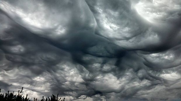
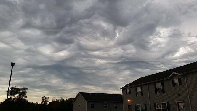
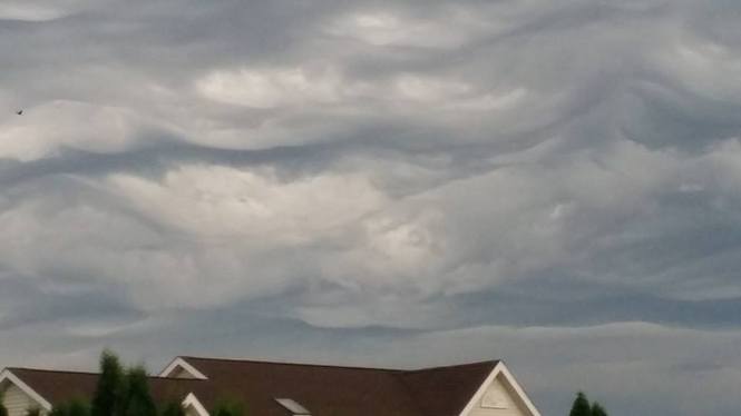
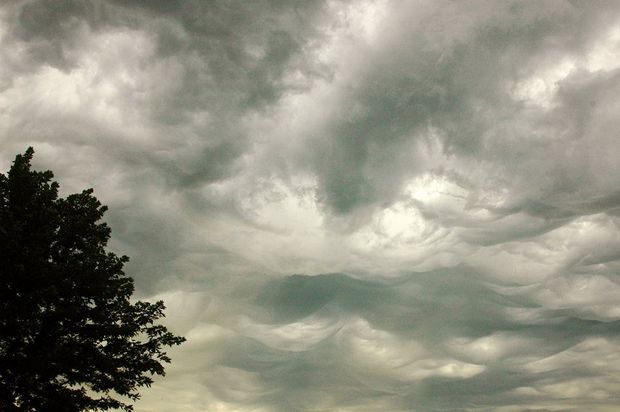
They are from the fourth.
originally posted by: gunshooter
originally posted by: proob4
The last storm was crazy, last i heard 400,000 customers where without power. The clouds seen over Kalamazoo the other day where incredible.
Here are some pics I nabbed off Mlive.com
That's crazy, what date did I you see those, we had clouds exactly like that over Duluth MN on the fourth! I wonder if we will break the record for colder than mars like we did last year?
originally posted by: beezzer
a reply to: rickymouse
It's just wild, I guess. Technology, electricity, access to city water/sewer/power has actually made us more frail in the face of weather that (100 years ago) people would have taken in stride.
So true. Strange to hear so much good philosophy coming from a mangy rabbit.
That exact region is where I believe the already here Ice Age will begin to take back what belongs to it.
That's how the the Great Lakes got there in the first place.
That exact region will also be the first place a mass exodus will take place in as little as 2 to 5 years.
The winter of 2015 will be the one of the coldest on record for the Great Lakes .
That is until 2016.
That's how the the Great Lakes got there in the first place.
That exact region will also be the first place a mass exodus will take place in as little as 2 to 5 years.
The winter of 2015 will be the one of the coldest on record for the Great Lakes .
That is until 2016.
Who knows?
Certainly seems a guessing game at time:
[from 3AM today]
www.crh.noaa.gov...
Certainly seems a guessing game at time:
[from 3AM today]
An impressive plume of moisture with precipitable water
values near 2.0 inches looks to surge up into Michigan Wednesday ahead of the cold front, guided by a strong 50-65 knot low-level jet. Showers and thunderstorms are expected to develop ahead/along the cold front as it pushes through Wednesday evening. How much instability can sneak up into Michigan is still in question, and will depend on the low track and whether the system occludes to our south ( GFS/Euro ) or overhead ( NAM ). The track has varied a little over the past few days as models struggle with the placement of multiple upper features and split flow, but a general trend to the
north has been noted.
www.crh.noaa.gov...
the 3am today update
www.crh.noaa.gov...
FTR, most of Wisconsin, most of Iowa, parts of Illinois and Indiana is under a Flash Flood Watch, STAY SAFE guys:
www.wunderground.com...
The current SEVERE US map
www.wunderground.com...
Expect numerous showers and thunderstorms to move across the area by late afternoon and evening, either from upstream convection
ongoing at the start of the day or stuff the redevelops over the region from daytime heating and erosion/mixing out of an early-day cap. Still some question as to severe weather potential ahead of and along the cold front that will move through during the evening. Front looks to occlude either just south of us or over southern Lower Michigan, potentially keeping surface-based instability south of the area. While sb and mu cape values are not all that impressive either way ( 500-1000 j/kg ahead of front ), shear and lift will be strong and could offset lack of strong instability.
Damaging winds would be the greatest concern given potential for momentum transfer from strong winds ( barely ) aloft and moisture loading, although tornado potential certainly cannot be ruled out given impressive shear, particularly in the lower levels, and lowering LCL heights as deeper moisture arrives. Potential for very heavy periods of rain with shower/thunderstorms looks high give high precipitable water values and forecast soundings that show tall/skinny cape, high freezing levels, and deep-layer saturation ahead of the front. Storms will to be fast-moving however, at 50-60 mph.
www.crh.noaa.gov...
FTR, most of Wisconsin, most of Iowa, parts of Illinois and Indiana is under a Flash Flood Watch, STAY SAFE guys:
www.wunderground.com...
* From late tonight through Wednesday afternoon
* heavy rainfall rates of 1 to 2 inches per hour is possible at times after midnight through Wednesday morning. Widespread storm total rainfall of 1 to 3 inches is expected with locally higher amounts in areas where the thunderstorms train over the same locations over a longer period and storms with higher per hour rainfall rates.
* Anyone with travel plans later tonight into Wednesday morning will want to stay alert to the latest weather conditions as roads may be washed out or have moving water over them. Visibility will also likely be very low from the heavy rainfall rates.
The current SEVERE US map
www.wunderground.com...
edit on Tue Sep 9 2014 by DontTreadOnMe because: clarity
new topics
-
Any one suspicious of fever promotions events, major investor Goldman Sachs card only.
The Gray Area: 1 hours ago -
God's Righteousness is Greater than Our Wrath
Religion, Faith, And Theology: 6 hours ago -
Electrical tricks for saving money
Education and Media: 9 hours ago -
VP's Secret Service agent brawls with other agents at Andrews
Mainstream News: 10 hours ago -
Sunak spinning the sickness figures
Other Current Events: 11 hours ago -
Nearly 70% Of Americans Want Talks To End War In Ukraine
Political Issues: 11 hours ago
top topics
-
VP's Secret Service agent brawls with other agents at Andrews
Mainstream News: 10 hours ago, 9 flags -
Cats Used as Live Bait to Train Ferocious Pitbulls in Illegal NYC Dogfighting
Social Issues and Civil Unrest: 14 hours ago, 8 flags -
Electrical tricks for saving money
Education and Media: 9 hours ago, 4 flags -
Nearly 70% Of Americans Want Talks To End War In Ukraine
Political Issues: 11 hours ago, 3 flags -
Sunak spinning the sickness figures
Other Current Events: 11 hours ago, 3 flags -
Late Night with the Devil - a really good unusual modern horror film.
Movies: 13 hours ago, 2 flags -
Any one suspicious of fever promotions events, major investor Goldman Sachs card only.
The Gray Area: 1 hours ago, 2 flags -
The Good News According to Jesus - Episode 1
Religion, Faith, And Theology: 16 hours ago, 1 flags -
God's Righteousness is Greater than Our Wrath
Religion, Faith, And Theology: 6 hours ago, 0 flags
active topics
-
Definitive 9.11 Pentagon EVIDENCE.
9/11 Conspiracies • 423 • : Lazy88 -
God's Righteousness is Greater than Our Wrath
Religion, Faith, And Theology • 11 • : andy06shake -
SETI chief says US has no evidence for alien technology. 'And we never have'
Aliens and UFOs • 60 • : Scratchpost -
Election Year 2024 - Interesting Election-Related Tidbits as They Happen.
2024 Elections • 73 • : Threadbarer -
Sunak spinning the sickness figures
Other Current Events • 8 • : McUrnsalso -
-@TH3WH17ERABB17- -Q- ---TIME TO SHOW THE WORLD--- -Part- --44--
Dissecting Disinformation • 661 • : Justoneman -
HORRIBLE !! Russian Soldier Drinking Own Urine To Survive In Battle
World War Three • 36 • : TheMisguidedAngel -
British TV Presenter Refuses To Use Guest's Preferred Pronouns
Education and Media • 146 • : Consvoli -
Nearly 70% Of Americans Want Talks To End War In Ukraine
Political Issues • 19 • : Consvoli -
Terrifying Encounters With The Black Eyed Kids
Paranormal Studies • 76 • : Consvoli