It looks like you're using an Ad Blocker.
Please white-list or disable AboveTopSecret.com in your ad-blocking tool.
Thank you.
Some features of ATS will be disabled while you continue to use an ad-blocker.

Hurricane MARIE Possible Threat to Southern California and Mexico?
page: 14
share:
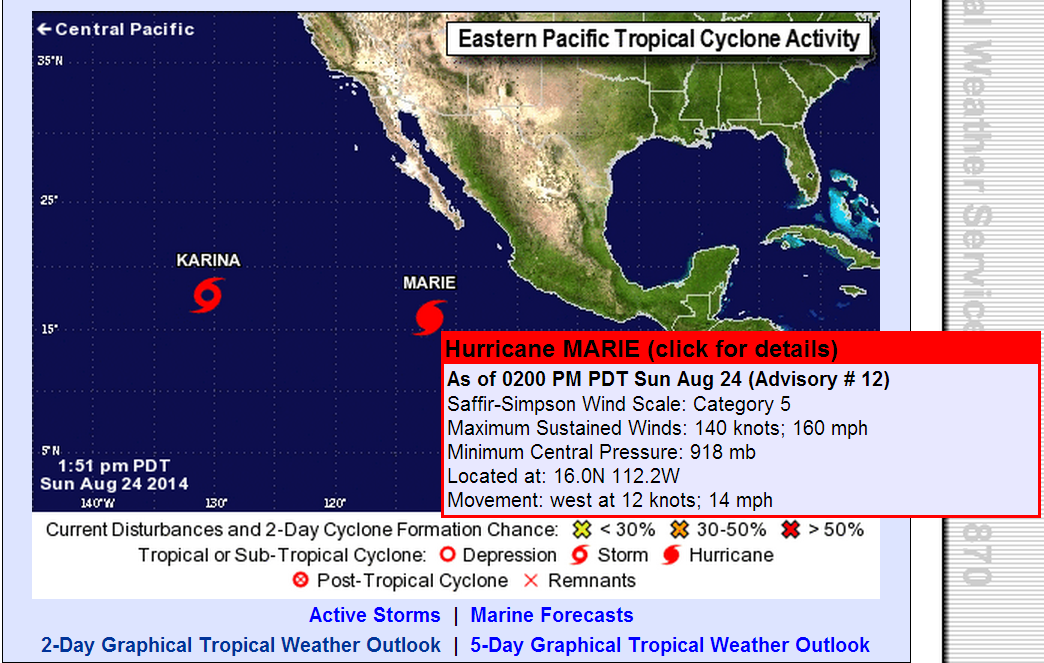
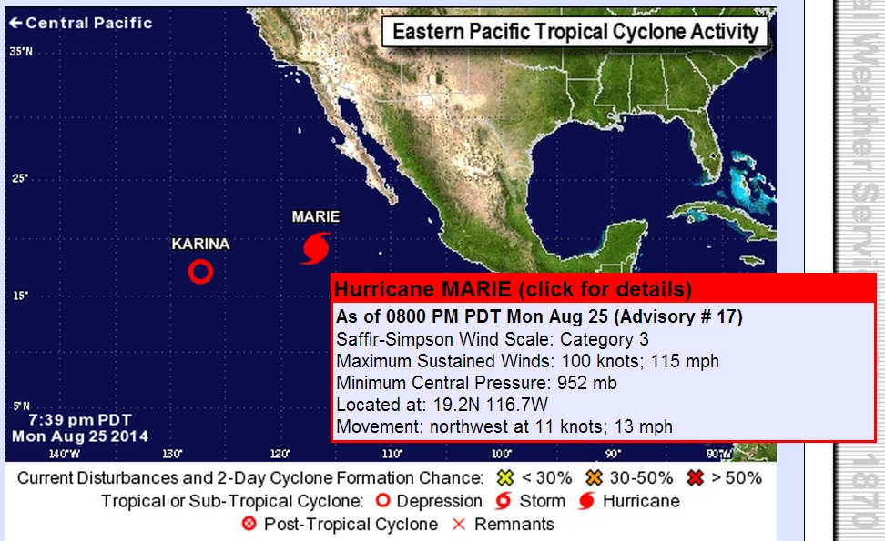
I just notice Hurricane MARIE is now a Catagory 5 Hurricane!!! ???
It was no were near that powerful on Saturday night.
Its absorbing Tropical storms Karinas power becoming stronger.
files.abovetopsecret.com...
www.nhc.noaa.gov...
files.abovetopsecret.com...
files.abovetopsecret.com...
files.abovetopsecret.com...
files.abovetopsecret.com...
It was no were near that powerful on Saturday night.
Its absorbing Tropical storms Karinas power becoming stronger.
files.abovetopsecret.com...
www.nhc.noaa.gov...
files.abovetopsecret.com...
files.abovetopsecret.com...
files.abovetopsecret.com...
files.abovetopsecret.com...
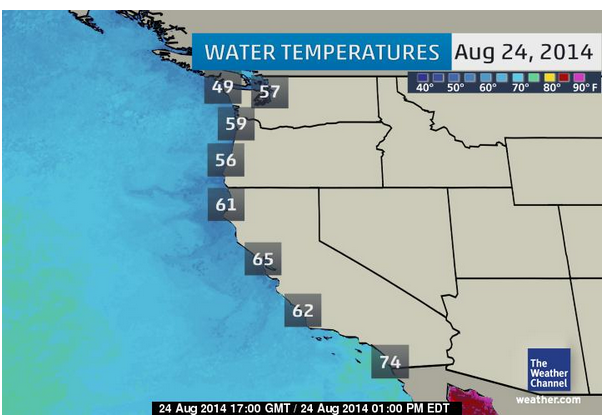
edit on 7/30/2012 by dreamfox1 because: water temperature at coast
Big earthquake now a hurricane could hit them. Not a good week for California sadly. The National Hurricane Center on that page said that by Tuesday
Marie could cause dangerous swells in Southern California. Are businesses preparing or does it look same old down there?
a reply to: dreamfox1
If you watch this for a few in terms of what is occurring when the hurricanes are moving northward, you'll see that they are essentially dissipating against what I believe is the high pressure ridge that is the source of the drought in California. At worst, California might get some much need rain but I doubt it's going to maintain its strengthen after hitting that ridge.
climate.cod.edu...
a reply to: WhiteAlice
I hope you are right about the Ridge and it gives us the needed rain were we need it.
I hope you are right about the Ridge and it gives us the needed rain were we need it.
a reply to: WhiteAlice
Also with water temperatures in the low 70s and 60s it would cause rapid dissipation, i.e how both Katrina and Rita rapidly went from a CAT 5 to a CAT 3 when they were approaching the shore, the waters are a lot cooler in California than they were in the Gulf of Mexico in 2005, so Marie would likely weaken even more. and btw, its because of the High Pressure that Marie will stay away from the coast, High Pressures push storm to the west-northwest most of the time. If California were to have a Low Pressure it would push it to the coast. But the High Pressure itself won't usually weaken the storm, just steer it, i.e Hurricane Katrina as it passed the Florida Keys in 2005, and Hurricane Ike in 2008, both were pushed west by a high pressure ridge.
Also with water temperatures in the low 70s and 60s it would cause rapid dissipation, i.e how both Katrina and Rita rapidly went from a CAT 5 to a CAT 3 when they were approaching the shore, the waters are a lot cooler in California than they were in the Gulf of Mexico in 2005, so Marie would likely weaken even more. and btw, its because of the High Pressure that Marie will stay away from the coast, High Pressures push storm to the west-northwest most of the time. If California were to have a Low Pressure it would push it to the coast. But the High Pressure itself won't usually weaken the storm, just steer it, i.e Hurricane Katrina as it passed the Florida Keys in 2005, and Hurricane Ike in 2008, both were pushed west by a high pressure ridge.
a reply to: IngyBall
Yep. If I recall correctly, that's what I've been seeing happening previously with other storm systems shooting up towards Japan but super tired today so not trusting my memory much. Basically, it's like watching pool balls hitting each other on a pool table and absolutely, water temp is a factor. The weather is really amazing, isn't it?
More on that thing though last I saw, it was dissipating somewhat. Sure hope so: news.stanford.edu...
Hurricane Marie isn't going to hit Southern California. Doesn't look like any rain either. They'll definitely get some large surf, but that's
about it. If it was going up the Gulf of California, then I'd be worried.
Tropical Storm Remnants from tropical cyclones have hit calif before and will again.
en.wikipedia.org...
Many calif rainfall records have been set by these Tropical Storm Remnants
en.wikipedia.org...
Many calif rainfall records have been set by these Tropical Storm Remnants
files.abovetopsecret.com...
All i going to say is.........We are going to get a ton of rain if it keeps on its current path.
And if it keeps heading north its going to cause massive coast damage due to very strong waves.
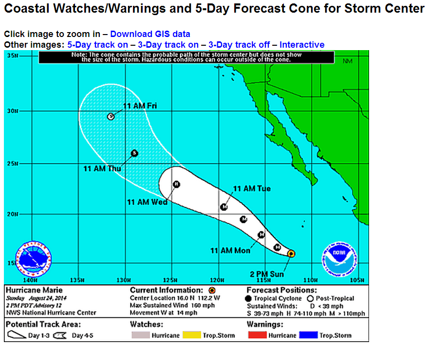
Cat 3 Marie
files.abovetopsecret.com...
The voice inside me keeps saying "Die just die already"
files.abovetopsecret.com...
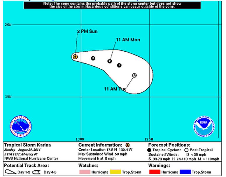
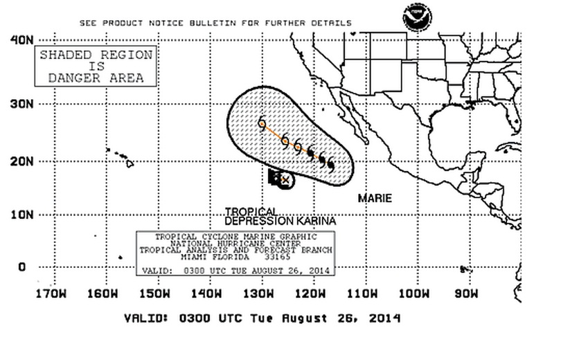
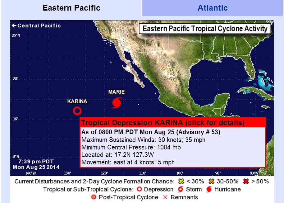
Then we have Tropical Depression KARINA slowly being devoured by Marie.
edit on 7/30/2012 by dreamfox1 because: Marie
a reply to: dreamfox1
A ton of rain? Really doubt it. While we could use it to be sure, I haven't seen any forecast predicting any rain for southern Ca.
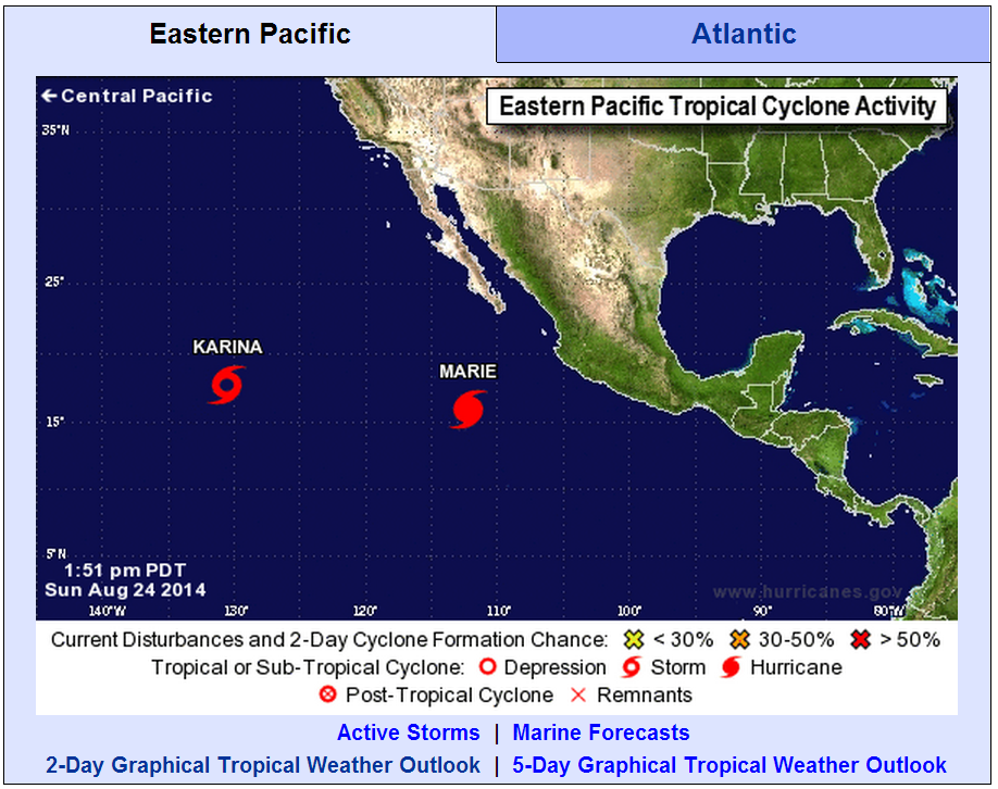
NOAA forcast for Marie:
NOAA
Again, the only thing you're going to get is some large surf at the very south facing beaches. For a good show, go find a web cam of the "The Wedge" in Newport Beach. Now that will be something to see!
A ton of rain? Really doubt it. While we could use it to be sure, I haven't seen any forecast predicting any rain for southern Ca.
NOAA forcast for Marie:
NOAA
Continued slow weakening is expected in the short term due to gradually decreasing sea surface temperatures and the possibility of the current eyewall replacement evolving further. Even though the vertical shear is forecast to be light, Marie will be crossing the 26 deg C isotherm in 12-18 hours and should reach sub-24 deg C waters by 48 hours. With the thermodynamic environment worsening so quickly, near-rapid weakening is likely after about 24 hours until the cyclone becomes post-tropical by day 3. The cyclone will then continue to spin down over even cooler waters, but the remnant circulation could linger beyond the end of the forecast period. The intensity forecast has been lowered a bit relative to the previous one due mostly to the greater rate of weakening observed since the last advisory.
Again, the only thing you're going to get is some large surf at the very south facing beaches. For a good show, go find a web cam of the "The Wedge" in Newport Beach. Now that will be something to see!
a reply to: surfinguru
I agree, Looks like just some big surf, some coastal flooding and beach erosion.
High Surf Advisory:
Orange County to be hit hardest.
Big Surf, if conditions are good, look for an epic day
Link to article
The Wedge WebCam
I agree, Looks like just some big surf, some coastal flooding and beach erosion.
High Surf Advisory:
The National Weather Service has issued a high surf advisory for today through Friday, with large surf, strong rip currents and sets as high as 15 feet.
The wells will produce large surf, strong rip currents and strong longshore currents this afternoon through Thursday, and minor coastal flooding and beach erosion also are possible.
Orange County to be hit hardest.
Surf of 8 to 10 feet will begin at some beaches, “mainly in Northern Orange County,” on Tuesday, becoming more widespread Tuesday night and Wednesday across Orange County, the advisory said.
Big Surf, if conditions are good, look for an epic day
Occasional sets at some beaches could be 12 to 15 feet, the advisory said. The southerly swell will fade Wednesday Night and Thursday but Orange County surf will continue above 7 feet through Thursday, the advisory said.
Link to article
The Wedge WebCam
edit on 26-8-2014 by Observationalist because: (no reason given)
a reply to: surfinguru
Yep, pretty much. If it follows the same pattern as the prior, any precipitation is going to pass California. Again. Really feeling bad for California about now.
climate.cod.edu...
Yep, pretty much. If it follows the same pattern as the prior, any precipitation is going to pass California. Again. Really feeling bad for California about now.
climate.cod.edu...
It's just going to feed the plate tension a little. Nothing to worry about, they are used to daily quakes in California.
Water beating on the coast does increase the energy level of the plates I have read. This does not mean a big quake will occur though, maybe just more baby ones.
Water beating on the coast does increase the energy level of the plates I have read. This does not mean a big quake will occur though, maybe just more baby ones.
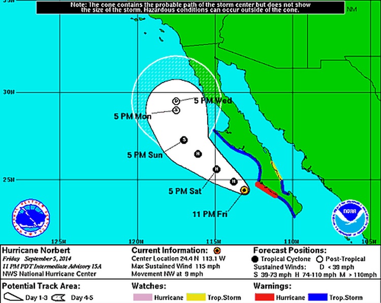

a reply to: dreamfox1
Norbert hit the ridge, went splat and well, S. California got the precipitation they needed, just all at once.
climate.cod.edu...
The good thing is that it looks like that dark wall to the left of California (ridge) is deteriorating even more after Norbert splat against it. That would be excellent for California as that could mean rain will actually start reaching the state. Fingers crossed.
new topics
-
Late Night with the Devil - a really good unusual modern horror film.
Movies: 1 hours ago -
Cats Used as Live Bait to Train Ferocious Pitbulls in Illegal NYC Dogfighting
Social Issues and Civil Unrest: 3 hours ago -
The Good News According to Jesus - Episode 1
Religion, Faith, And Theology: 4 hours ago -
HORRIBLE !! Russian Soldier Drinking Own Urine To Survive In Battle
World War Three: 7 hours ago -
Bobiverse
Fantasy & Science Fiction: 9 hours ago -
Florida man's trip overseas ends in shock over $143,000 T-Mobile phone bill
Social Issues and Civil Unrest: 9 hours ago
top topics
-
Florida man's trip overseas ends in shock over $143,000 T-Mobile phone bill
Social Issues and Civil Unrest: 9 hours ago, 8 flags -
SETI chief says US has no evidence for alien technology. 'And we never have'
Aliens and UFOs: 13 hours ago, 7 flags -
Cats Used as Live Bait to Train Ferocious Pitbulls in Illegal NYC Dogfighting
Social Issues and Civil Unrest: 3 hours ago, 7 flags -
This is our Story
General Entertainment: 16 hours ago, 4 flags -
Former Labour minister Frank Field dies aged 81
People: 12 hours ago, 4 flags -
Bobiverse
Fantasy & Science Fiction: 9 hours ago, 3 flags -
HORRIBLE !! Russian Soldier Drinking Own Urine To Survive In Battle
World War Three: 7 hours ago, 2 flags -
Late Night with the Devil - a really good unusual modern horror film.
Movies: 1 hours ago, 2 flags -
The Good News According to Jesus - Episode 1
Religion, Faith, And Theology: 4 hours ago, 0 flags
active topics
-
Late Night with the Devil - a really good unusual modern horror film.
Movies • 2 • : WhitewaterSquirrel -
British TV Presenter Refuses To Use Guest's Preferred Pronouns
Education and Media • 141 • : rigel4 -
President BIDEN Vows to Make Americans Pay More Federal Taxes in 2025 - Political Suicide.
2024 Elections • 99 • : DBCowboy -
HORRIBLE !! Russian Soldier Drinking Own Urine To Survive In Battle
World War Three • 23 • : Disgusted123 -
Hi folks I'm Leon Grad
Introductions • 9 • : leongrad -
The Reality of the Laser
Military Projects • 41 • : 5thHead -
Thousands Of Young Ukrainian Men Trying To Flee The Country To Avoid Conscription And The War
Other Current Events • 136 • : NorthOS -
Cats Used as Live Bait to Train Ferocious Pitbulls in Illegal NYC Dogfighting
Social Issues and Civil Unrest • 8 • : lordcomac -
Florida man's trip overseas ends in shock over $143,000 T-Mobile phone bill
Social Issues and Civil Unrest • 16 • : grey580 -
SETI chief says US has no evidence for alien technology. 'And we never have'
Aliens and UFOs • 35 • : Consvoli
4