It looks like you're using an Ad Blocker.
Please white-list or disable AboveTopSecret.com in your ad-blocking tool.
Thank you.
Some features of ATS will be disabled while you continue to use an ad-blocker.

Flightaware Changed the Flight History Data of MH17.
page: 1share:
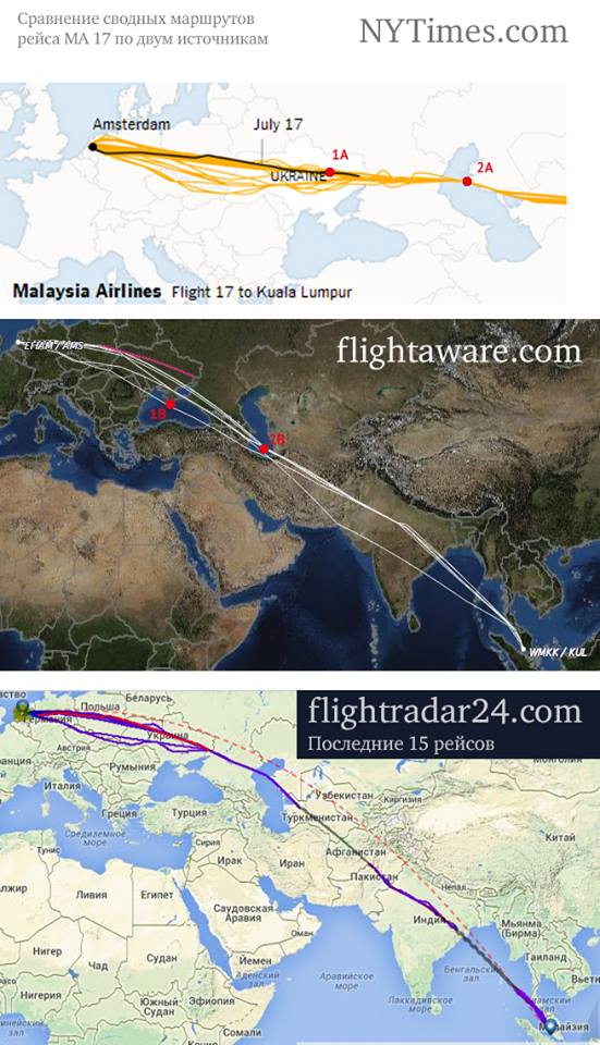
Flightaware changed the flight history data of MH17.
This pic was based on the flight history of MH17 as it appeared on Flightaware.com, days after the shoot down. This pic was created and posted on the web, also days after the crash.
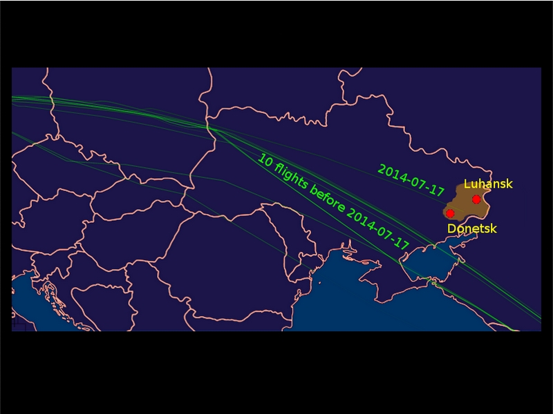
As you can see, in the ten days prior, all flights went across the Sea of Azov, or below it.
I am sure someone will come in and attack this pic saying it's not an original Flightaware pic.
Whatever, I saw the flights on Flightaware like this with my own eyes, at the time.
Now they are all shown going north of the Sea of Azov.
I checked back to July 7th and almost all, if not all do, now
They didn't 1.5 week ago.
Here's July 14, 15 and 16.
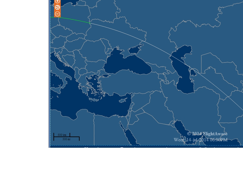
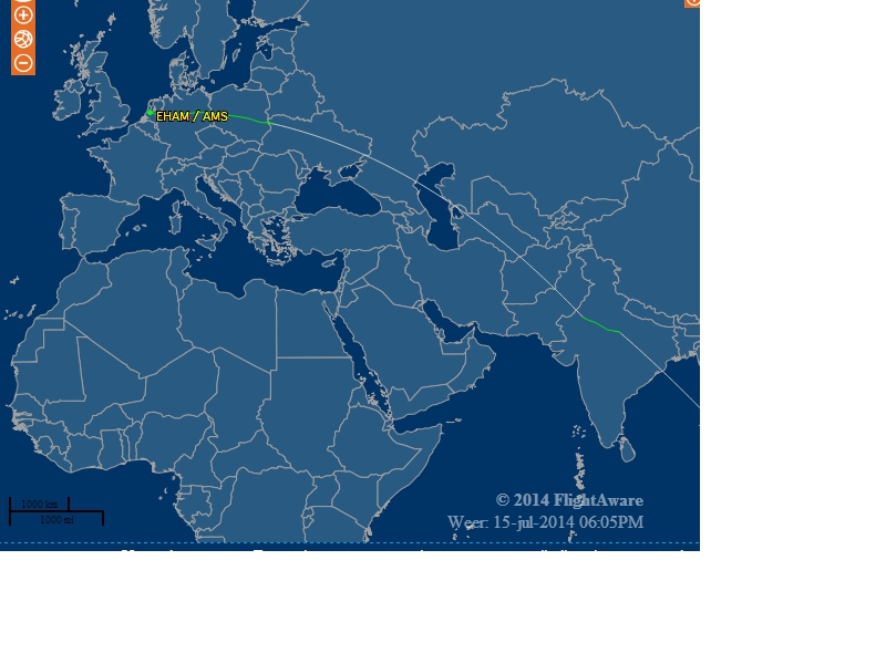
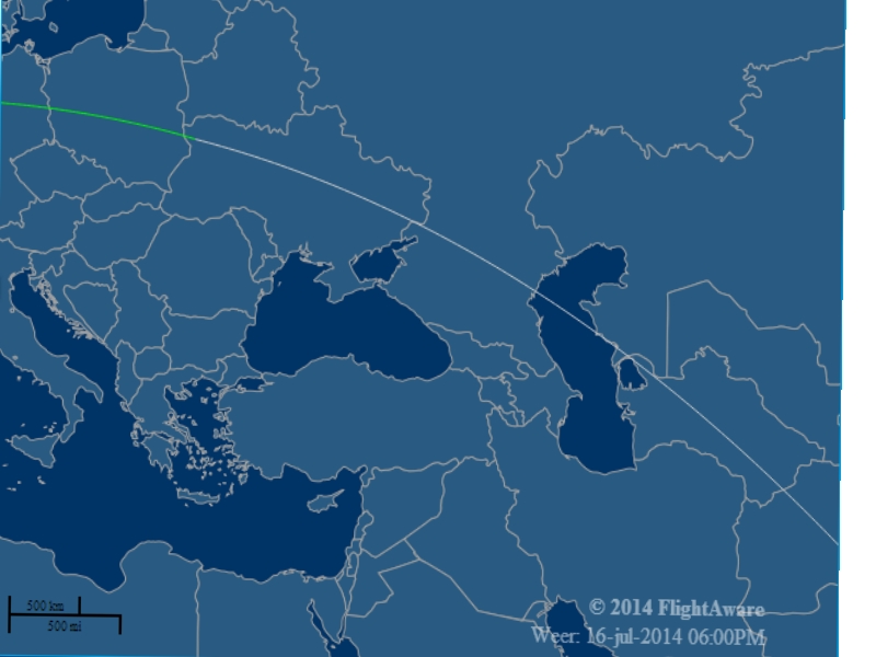
Compare to the above pic.
Now why was this flight data changed?
I think the answer is obvious.
This pic was based on the flight history of MH17 as it appeared on Flightaware.com, days after the shoot down. This pic was created and posted on the web, also days after the crash.
As you can see, in the ten days prior, all flights went across the Sea of Azov, or below it.
I am sure someone will come in and attack this pic saying it's not an original Flightaware pic.
Whatever, I saw the flights on Flightaware like this with my own eyes, at the time.
Now they are all shown going north of the Sea of Azov.
I checked back to July 7th and almost all, if not all do, now
They didn't 1.5 week ago.
Here's July 14, 15 and 16.
Compare to the above pic.
Now why was this flight data changed?
I think the answer is obvious.
edit on 31-7-2014 by NotADroidUAreLooking4 because: (no reason given)
a reply to: NotADroidUAreLooking4
Wow, if true, good catch.
I first saw the original post in ZeroHedge. Strangely, it seems to have gotten little attention.
Wow, if true, good catch.
I first saw the original post in ZeroHedge. Strangely, it seems to have gotten little attention.
a reply to: NotADroidUAreLooking4
FlightAware didn't change anything. They refined using other data. FlightAware, if you look closely doesn't have the ADS-B coverage of Europe as other sites do. That means they use estimated positions for some parts of the flight, based on flight plans.
If you read the flight information in detail, and look at the actual position of the flight (this is from the 16th of July), then from 06:58 51.1320 24.8415 98° East it shows the Location/Type as "Estimated", all the way until it reaches 12:02 27.4877 74.3889 116° Southeast. Then again, from 12:45 24.6822 79.9684 133° Southeast, all the way until 15:58 6.9840 97.8896 138° Southeast it's Estimated again. Again from 16:44 2.7812 101.6878 148° Southeast until landing in Kuala Lumpur.
That's because for that big stretch of Europe, they don't have coverage. But if you look at the replay on other tracking sites, such as FlightRadar24, you get better coverage in Europe. If you take the two, and put them together, you get a pretty good picture of where the flight really was, and what was going on at the time things happened. And both agree that the flight was over Ukrainian airspace, didn't turn around at any point, and suddenly stopped broadcasting.
Truth being one of the first causalities of war your's will be remembered by few and forgotten by many .Listening to a discussion tonight on the
radio ,the so called experts have a different take on who ,what ,when.where,why and how things went down .The MSM are reading from a script written by
the Neo-cons in Washington so any truth you bring to the table will be like the 911 truths that were ignored by tptb . Hopefully though ,what you have
brought may help convince just one more person that we are not being told the truth ....peace
a reply to: Zaphod58
Lol, I see, replace the word "change" with "refine" and suddenly it doesn't mean change anymore.
So you are arguing that the data is still the same?
And when I look back at today's flight in two weeks it will look different from how it looks today, because they "refined" the data?
This is truly entertaining.
FlightAware didn't change anything. They refined using other data.
Lol, I see, replace the word "change" with "refine" and suddenly it doesn't mean change anymore.
So you are arguing that the data is still the same?
And when I look back at today's flight in two weeks it will look different from how it looks today, because they "refined" the data?
This is truly entertaining.
a reply to: NotADroidUAreLooking4
I'm arguing that the initial data was wrong. It wasn't changed in the sense that they are trying to hide something, which is what you implied. FlightAware and other tracking sites work by receivers on the ground, if here isn't a ground receiver, then they have to estimate based on previous positions, aircraft speed, and filed flight plan. Which is what they did.
They later went back and refined the data using multiple sources, and showed the correct information.
But why let a little something like that get in the way of a good conspiracy, right?
edit on 7/31/2014 by Zaphod58 because: (no reason
given)
a reply to: Zaphod58
So this is their usual method?
So if I take screenshots of todays flight they will be different from those of next week, of the same date?
Seems like this is something we can test, right?
They later went back and refined the data using multiple sources, and showed the correct information.
So this is their usual method?
So if I take screenshots of todays flight they will be different from those of next week, of the same date?
Seems like this is something we can test, right?
edit on 31-7-2014 by NotADroidUAreLooking4 because: (no reason given)
a reply to: NotADroidUAreLooking4
then all KIEV has to do is release the Air Traffic Control tower tapes,, which they have yet too do.
then all KIEV has to do is release the Air Traffic Control tower tapes,, which they have yet too do.
a reply to: NotADroidUAreLooking4
And so have a lot of people on either side of this argument. Both sides have used the data, but somehow it's wrong for me to use it suddenly? It has been used from the start to trumpet how Kiev ordered the plane to fly over the region on this particular day. Are you going to bring it up for all those posts too? Or just my use of it?
It doesn't mean that it's wrong data. It simply means that it's best to use other data to back it up, or check it against, which FR24 does. Both FR24 and FlightAware show that the flights were on basically the same path as on other days.
a reply to: Zaphod58
Yes off course they do, now.
Are you avoiding this question?
Btw, I had already retracted that post cause I misinterpreted the context. My bad.
Both FR24 and FlightAware show that the flights were on basically the same path as on other days.
Yes off course they do, now.
Are you avoiding this question?
So if I take screenshots of todays flight they will be different from those of next week, of the same date?
Btw, I had already retracted that post cause I misinterpreted the context. My bad.
a reply to: NotADroidUAreLooking4
I'm not avoiding any questions. Data changes during a crash investigation a lot. I've seen it change a lot worse than this in some investigations. Yes, they agree now, because it has since been refined.
FlightAware and FR24 are great for people to figure out what flights are going over their heads, and for finding out when family members, or even their own flights are going to land. They are NOT meant to be used for crash investigation, although they can be used for rough data.
a reply to: NotADroidUAreLooking4
Not trying to butt in on the conversation, but Zaph is our resident "know-it-all" when it comes to aviation and such. I'm not sure, but I believe he addressed this one before in a different thread.
Anyway, you can trust that what he is saying is correct.
Not trying to butt in on the conversation, but Zaph is our resident "know-it-all" when it comes to aviation and such. I'm not sure, but I believe he addressed this one before in a different thread.
Anyway, you can trust that what he is saying is correct.
edit on 7/31/2014 by sheepslayer247 because: (no reason given)
a reply to: NotADroidUAreLooking4
Because it's been trotted out repeatedly to prove that the Ukrainian Air Traffic Control ordered the flight into dangerous airspace or to turn around so they could shoot it down. So using the same data from the same source that they used, I used it to prove that they were wrong.
Because it's been trotted out repeatedly to prove that the Ukrainian Air Traffic Control ordered the flight into dangerous airspace or to turn around so they could shoot it down. So using the same data from the same source that they used, I used it to prove that they were wrong.
edit on
7/31/2014 by Zaphod58 because: (no reason given)
a reply to: sheepslayer247
Pfff, spare me your anecdotes and meaningless titles.
Yes, these are not the droids I am looking for.......
If you have nothing to offer then please don't post in my thread.
Not trying to butt in on the conversation, but Zaph is our resident "know-it-all" when it comes to aviation and such.
Pfff, spare me your anecdotes and meaningless titles.
Anyway, you can trust that what he is saying is correct.
Yes, these are not the droids I am looking for.......
If you have nothing to offer then please don't post in my thread.
a reply to: NotADroidUAreLooking4
I have no idea. I don't have access to the data, I only have access to the website. I'm not an investigator, and neither are you. They may be able to get data that shows it in more detail, and make it more accurate, and make slight changes to it. It could be different tomorrow, or it could never change again.
I have no idea. I don't have access to the data, I only have access to the website. I'm not an investigator, and neither are you. They may be able to get data that shows it in more detail, and make it more accurate, and make slight changes to it. It could be different tomorrow, or it could never change again.
new topics
-
George Knapp AMA on DI
Area 51 and other Facilities: 4 hours ago -
Not Aliens but a Nazi Occult Inspired and then Science Rendered Design.
Aliens and UFOs: 4 hours ago -
Louisiana Lawmakers Seek to Limit Public Access to Government Records
Political Issues: 7 hours ago -
The Tories may be wiped out after the Election - Serves them Right
Regional Politics: 8 hours ago -
So I saw about 30 UFOs in formation last night.
Aliens and UFOs: 10 hours ago -
Do we live in a simulation similar to The Matrix 1999?
ATS Skunk Works: 11 hours ago -
BREAKING: O’Keefe Media Uncovers who is really running the White House
US Political Madness: 11 hours ago
top topics
-
BREAKING: O’Keefe Media Uncovers who is really running the White House
US Political Madness: 11 hours ago, 23 flags -
George Knapp AMA on DI
Area 51 and other Facilities: 4 hours ago, 19 flags -
Biden--My Uncle Was Eaten By Cannibals
US Political Madness: 12 hours ago, 18 flags -
African "Newcomers" Tell NYC They Don't Like the Free Food or Shelter They've Been Given
Social Issues and Civil Unrest: 17 hours ago, 12 flags -
"We're All Hamas" Heard at Columbia University Protests
Social Issues and Civil Unrest: 12 hours ago, 7 flags -
Louisiana Lawmakers Seek to Limit Public Access to Government Records
Political Issues: 7 hours ago, 7 flags -
Russian intelligence officer: explosions at defense factories in the USA and Wales may be sabotage
Weaponry: 16 hours ago, 6 flags -
So I saw about 30 UFOs in formation last night.
Aliens and UFOs: 10 hours ago, 5 flags -
The Tories may be wiped out after the Election - Serves them Right
Regional Politics: 8 hours ago, 3 flags -
Not Aliens but a Nazi Occult Inspired and then Science Rendered Design.
Aliens and UFOs: 4 hours ago, 3 flags
active topics
-
Election Year 2024 - Interesting Election-Related Tidbits as They Happen.
2024 Elections • 64 • : Zanti Misfit -
Biden--My Uncle Was Eaten By Cannibals
US Political Madness • 45 • : RazorV66 -
Truth Social goes public, be careful not to lose your money
Mainstream News • 119 • : Kaiju666 -
George Knapp AMA on DI
Area 51 and other Facilities • 14 • : Brotherman -
Candidate TRUMP Now Has Crazy Judge JUAN MERCHAN After Him - The Stormy Daniels Hush-Money Case.
Political Conspiracies • 383 • : xuenchen -
OUT OF THE BLUE Chilling moment pulsating blue cigar-shaped UFO is filmed hovering over PHX AZ
Aliens and UFOs • 42 • : Ophiuchus1 -
-@TH3WH17ERABB17- -Q- ---TIME TO SHOW THE WORLD--- -Part- --44--
Dissecting Disinformation • 531 • : cherokeetroy -
So I saw about 30 UFOs in formation last night.
Aliens and UFOs • 20 • : Halfswede -
MULTIPLE SKYMASTER MESSAGES GOING OUT
World War Three • 33 • : Halfswede -
Not Aliens but a Nazi Occult Inspired and then Science Rendered Design.
Aliens and UFOs • 7 • : JonnyC555