It looks like you're using an Ad Blocker.
Please white-list or disable AboveTopSecret.com in your ad-blocking tool.
Thank you.
Some features of ATS will be disabled while you continue to use an ad-blocker.

NEW MH17 SENSATION: German experts point finger at Ukrainian air-force jets.
page: 9share:
originally posted by: Zaphod58
a reply to: Flatcoat
The wreckage will show parts missing after being looted, and whether it was a SAM or an air to air missile. So if it was a SAM, from rebel held territory, when there was a known rebel SAM in the region, that looks pretty bad for them. If they can keep them from investigating and recovering the pieces of missile to determine what kind if was, then they can keep pointing the finger at Kiev.
But there were also Ukrainian SAM's in the area, so if it was a BUK, that still doesn't prove who fired it.
a reply to: Flatcoat
Someone who makes pronouncements of fact, as an expert, who is not, is a hoaxster. Particularly if he has not even examined the wreckage.
The investigators can't even make it to the crash site (roads are now said to be mined) so how is it he has already examined the wreckage and made a determination that 30mm cannons shot the aircraft down? Not to mention shooting a 777 down with short range fire rather than just using a missile seems rather odd to me. Did they close on it to determine if it were a 777 before firing on it? Seems much more likely to fire a missile from about 50 miles away and then leave the area.
a reply to: Zaphod58
Timestamp debunked, but what about the cutting? It was made just for better understanding?
So I cannot trust youtube (what a surprise...)
What about flightradar24?
MH17 last flight
Is ADS–B credible?
Timestamp debunked, but what about the cutting? It was made just for better understanding?
So I cannot trust youtube (what a surprise...)
What about flightradar24?
MH17 last flight
Is ADS–B credible?
a reply to: maghun
That shows exactly what I have been saying all along. They filed for slightly north of where they were, but they were flying slightly south of their filed flight path from take off, most likely due to winds. They were at 33,000 feet, which was above restricted airspace, and there was no radical turn north as people claim. It was a straight line course from take off to where they were shot down.
If you look at other flights you will see that they were off their filed plan as well.
a reply to: Flatcoat
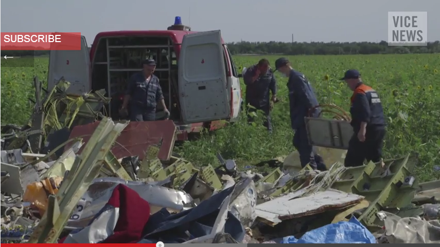
No it is a pretty clear case that the separatists are keeping investigators from getting to the site. And have removed debris.
www.voanews.com...
So again I have to ask if the separatists are innocent why not let the investigators do their jobs.
Guilty parties never want an investigation that can show they are guilty, which is why they hinder the investigation.
Would that be just speculation on your part?
No it is a pretty clear case that the separatists are keeping investigators from getting to the site. And have removed debris.
International observers in eastern Ukraine have turned back from the crash site of Malaysia Airlines Flight 17, after pro-Russian separatists once again prevented them entering the area.
European officials said after discussions with the rebels at the site, the observers from the Organization for Security and Cooperation in Europe returned to their base in the city of Donetsk.
Safety concerns are keeping international investigators away. A spokesman for Ukraine's National Security and Defense Council, Andriy Lysenko, said Wednesday rebels have placed land mines in the area around the crash site.
www.voanews.com...
So again I have to ask if the separatists are innocent why not let the investigators do their jobs.
Guilty parties never want an investigation that can show they are guilty, which is why they hinder the investigation.
a reply to: Zaphod58
If this flight path is correct, MH17 reached Snezhnoye. Eyewitnesses confirmed it in a BBC report.
Boeing downing coverup: BBC report removed
Somehow the plane crashed about 20 miles backward:
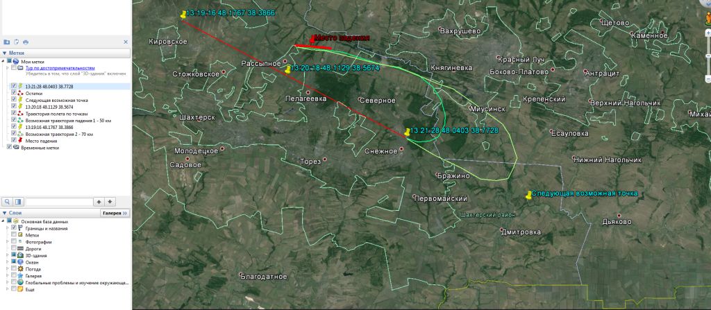
If this flight path is correct, MH17 reached Snezhnoye. Eyewitnesses confirmed it in a BBC report.
Boeing downing coverup: BBC report removed
Eyewitness #1: There were two explosions in the air. And this is how it broke apart. And [the fragments] blew apart like this, to the sides. And when …
Eyewitness #2: … And there was another aircraft, a military one, beside it. Everybody saw it.
Eyewitness #1: Yes, yes. It was flying under it, because it could be seen. It was proceeding underneath, below the civilian one.
Eyewitness #3: There were sounds of an explosion. But they were in the sky. They came from the sky. Then this plane made a sharp turn-around like this. It changed its trajectory and headed in that direction [indicating the direction with her hands].
Somehow the plane crashed about 20 miles backward:
edit on 07pm707u7 by maghun because: (no reason given)
a reply to: maghun
Then the eyewitnesses were wrong. The transponder would have shown anything like that, and eyewitnesses are frequently wrong when it comes to plane crashes.
If there were other planes in the area, the Russian radar data would have shown them on its radar, and it didn't.
Then the eyewitnesses were wrong. The transponder would have shown anything like that, and eyewitnesses are frequently wrong when it comes to plane crashes.
If there were other planes in the area, the Russian radar data would have shown them on its radar, and it didn't.
edit on 7/30/2014 by Zaphod58
because: (no reason given)
a reply to: Zaphod58
Are you sure that the Russians shared all their data? I don't think so...
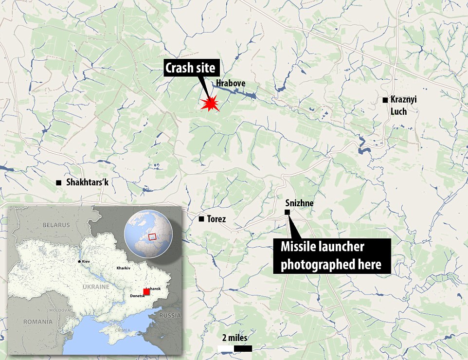
Check it on the map. Hrabove is the crash site. The last coordinates reported to flightradar from MH17 was Snizhne.
Last positions of #MH17 directly from Flightradar24 database. Signal was lost around 13:21 UTC at 33,000 feet.
Are you sure that the Russians shared all their data? I don't think so...
Check it on the map. Hrabove is the crash site. The last coordinates reported to flightradar from MH17 was Snizhne.
Last positions of #MH17 directly from Flightradar24 database. Signal was lost around 13:21 UTC at 33,000 feet.
a reply to: maghun
Actually what the lady says is ambiguous and it is not possible to clearly identify what aircraft - the fighter close to MH17, or MH17 itself - she is referring to:
With respect to the MH17 flightpath... if that pictorial representation is correct then, well, we have a doozy.
Edit: video contains photo evidence and recreation of location of SAM trail in the sky close to Snezhnoye. SA-11 has range of 42km max, altitude 25km max.
edit on 30-7-2014 by Blister because: (no reason given)
a reply to: maghun
It doesn't matter at all if the Russians released all their data. If there were other aircraft near MH17 when it was shot down, they would have been seen in the tape that was released that showed the plane falling.
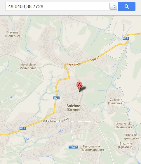
It's 16 miles from Hrabove to Snizhne. If you look at the exact position, it wasn't quite directly over Snizhne. The GPS coordinates for Snihne are 48.0283° N, 38.7656° E, the last coordinates reported by the ADS-B were 48.0403 N, 38.7723 E. That puts it still to the West of Snizhne.
It doesn't matter at all if the Russians released all their data. If there were other aircraft near MH17 when it was shot down, they would have been seen in the tape that was released that showed the plane falling.
It's 16 miles from Hrabove to Snizhne. If you look at the exact position, it wasn't quite directly over Snizhne. The GPS coordinates for Snihne are 48.0283° N, 38.7656° E, the last coordinates reported by the ADS-B were 48.0403 N, 38.7723 E. That puts it still to the West of Snizhne.
edit on 7/30/2014 by Zaphod58 because: (no reason given)
a reply to: tsurfer2000h
Canadian OSCE member was one of the first to arrive at the crash site. He is not an aviation expert, but gives some interesting statements in this report:
OSCE Bociurkiw, we saw signs of heavy machine guns, no sign of missle
Ukrainian government offensive blocks MH17 investigation
Canadian OSCE member was one of the first to arrive at the crash site. He is not an aviation expert, but gives some interesting statements in this report:
OSCE Bociurkiw, we saw signs of heavy machine guns, no sign of missle
However, the US and its allies, which accused pro-Russian separatists of shooting down MH17, of tampering with evidence and desecrating the bodies of the victims, have remained virtually silent on Kiev’s military offensive in recent days around the crash site.
No hue and cry has been raised by Western governments or the media about the Ukrainian military’s blocking of investigators. Nothing has been said about Kiev’s motives in initiating the fighting or preventing the collection of evidence from the site.
Ukrainian government offensive blocks MH17 investigation
originally posted by: Zaphod58
a reply to: Blister
No we don't, because those coordinates aren't over the center of the town. It's to the west of it, moving east. There is only 16 miles between the two towns, so that's about right for the coordinates.
Huh, "No we don't", what?
Not sure what you are saying here... me not give any coordinates...
All I said was:
close to Snezhnoye
You seem to concur(?).
Edit: You question if we have a doozy? To me yeah, the amazing thing would be if MH17 did a hairpin turn. That would be pretty incredible. Suggests, well... heck... was MH17 hit and trying to land somewhere? Evade attack? Flee from SAMs? Ordered by ATC to turn? Already out of control (maybe lost that wing the witnesses speak about)?
edit on 30-7-2014 by Blister because: (no reason given)
originally posted by: Zaphod58
a reply to: Blister
You said:
With respect to the MH17 flightpath... if that pictorial representation is correct then, well, we have a doozy.
It's not a doozy, because the coordinates are right about where it came down. West of the town, moving east.
So the flightpath graphic provided above (www.abovetopsecret.com...) is incorrect? MH17 did not turn around?
a reply to: Blister
No, it didn't. The coordinates for the center of the town are not the last coordinates of the flight. It was still west of there heading east. It's only 16 miles from the center of the town, to the last coordinates shown by FlightAware.
Coordinates for the town: 48.0283° N, 38.7656° E
Last coordinates of the flight: 48.0403 N, 38.7723 E
It hadn't reached there yet. If you look at the coordinates in the list, from the link to FlightAware, the flight is constantly moving East, and never goes back to the West.

new topics
-
Ditching physical money
History: 1 hours ago -
One Flame Throwing Robot Dog for Christmas Please!
Weaponry: 2 hours ago -
Don't take advantage of people just because it seems easy it will backfire
Rant: 2 hours ago -
VirginOfGrand says hello
Introductions: 3 hours ago -
Should Biden Replace Harris With AOC On the 2024 Democrat Ticket?
2024 Elections: 3 hours ago -
University student disciplined after saying veganism is wrong and gender fluidity is stupid
Education and Media: 6 hours ago -
Geddy Lee in Conversation with Alex Lifeson - My Effin’ Life
People: 7 hours ago -
God lived as a Devil Dog.
Short Stories: 7 hours ago -
Police clash with St George’s Day protesters at central London rally
Social Issues and Civil Unrest: 9 hours ago -
TLDR post about ATS and why I love it and hope we all stay together somewhere
General Chit Chat: 10 hours ago
top topics
-
Hate makes for strange bedfellows
US Political Madness: 12 hours ago, 18 flags -
Who guards the guards
US Political Madness: 14 hours ago, 13 flags -
University student disciplined after saying veganism is wrong and gender fluidity is stupid
Education and Media: 6 hours ago, 11 flags -
Police clash with St George’s Day protesters at central London rally
Social Issues and Civil Unrest: 9 hours ago, 8 flags -
TLDR post about ATS and why I love it and hope we all stay together somewhere
General Chit Chat: 10 hours ago, 7 flags -
Should Biden Replace Harris With AOC On the 2024 Democrat Ticket?
2024 Elections: 3 hours ago, 5 flags -
Has Tesla manipulated data logs to cover up auto pilot crash?
Automotive Discussion: 16 hours ago, 3 flags -
One Flame Throwing Robot Dog for Christmas Please!
Weaponry: 2 hours ago, 2 flags -
Don't take advantage of people just because it seems easy it will backfire
Rant: 2 hours ago, 2 flags -
Geddy Lee in Conversation with Alex Lifeson - My Effin’ Life
People: 7 hours ago, 2 flags
active topics
-
Ditching physical money
History • 9 • : VirginOfGrand -
The Superstition of Full Moons Filling Hospitals Turns Out To Be True!
Medical Issues & Conspiracies • 21 • : VirginOfGrand -
-@TH3WH17ERABB17- -Q- ---TIME TO SHOW THE WORLD--- -Part- --44--
Dissecting Disinformation • 633 • : Justoneman -
VirginOfGrand says hello
Introductions • 1 • : VirginOfGrand -
Candidate TRUMP Now Has Crazy Judge JUAN MERCHAN After Him - The Stormy Daniels Hush-Money Case.
Political Conspiracies • 740 • : matafuchs -
Should Biden Replace Harris With AOC On the 2024 Democrat Ticket?
2024 Elections • 33 • : BernnieJGato -
Gold and silver prices....woo hoo
History • 84 • : annonentity -
The Democrats Take Control the House - Look what happened while you were sleeping
US Political Madness • 108 • : Zanti Misfit -
BREAKING! Another Bridge Hit by a barge #3 this week.
Mainstream News • 110 • : RookQueen2 -
One Flame Throwing Robot Dog for Christmas Please!
Weaponry • 4 • : Dalamax