It looks like you're using an Ad Blocker.
Please white-list or disable AboveTopSecret.com in your ad-blocking tool.
Thank you.
Some features of ATS will be disabled while you continue to use an ad-blocker.

AZ residents at chemtrail hearing: ‘We’re being sprayed like we’re bugs and it’s really not
page: 22share:
originally posted by: vethumanbeing
None, we don't have commercial aircraft flying over this area.
And yet I "wouldn't believe the chemtrail problem you have"! Right! I wouldn't.
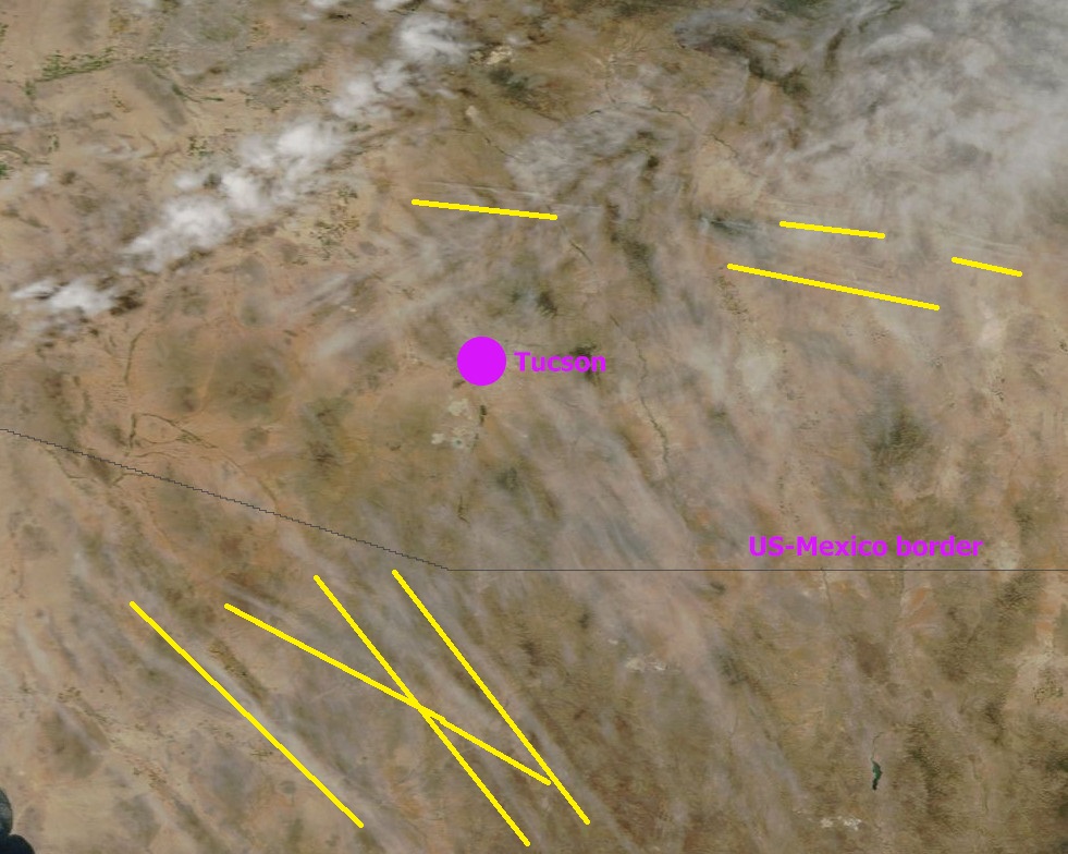
What do you have to say to the satellite picture from last month that I posted showing contrails over Tucson, extending way down into Mexico to the southeast of Tucson which you assured us was a no fly zone?

originally posted by: Rob48
a reply to: vethumanbeing
Why would a flight going over Tucson have to originate FROM Tucson?
Last time I checked there was quite a lot of land north of Arizona. Do they have aircraft in Canada these days? Do they fly to Mexico? How about South America?
If planes from Holland to the Caribbean, or New York to Belgium, are flying over my house, what makes you think all the planes over you are local? Some of them probably don't take off or land anywhere in the USA!
There are no planes flying over me (military only); and as I said there is no destination directly south for a 1000 miles of where I live that anyone would visit; unless its "Amnesty International", the Peace Corps or Unicef.
edit on 3-7-2014 by vethumanbeing because: (no reason
given)
originally posted by: Rob48
originally posted by: vethumanbeing
None, we don't have commercial aircraft flying over this area.
And yet I "wouldn't believe the chemtrail problem you have"! Right! I wouldn't.
What do you have to say to the satellite picture from last month that I posted showing contrails over Tucson, extending way down into Mexico to the southeast of Tucson which you assured us was a no fly zone?
Those aren't contrails, those are cloud patterns. We were experiencing highs here, 5% humidity if that 100+ temperatures, even at 35,000 feet any vapor trails would have disappeared as fast as they were expelled.
edit on 3-7-2014 by vethumanbeing because: (no reason given)
originally posted by: vethumanbeing
originally posted by: Rob48
originally posted by: vethumanbeing
None, we don't have commercial aircraft flying over this area.
And yet I "wouldn't believe the chemtrail problem you have"! Right! I wouldn't.
What do you have to say to the satellite picture from last month that I posted showing contrails over Tucson, extending way down into Mexico to the southeast of Tucson which you assured us was a no fly zone?
Those aren't contrails, those are cloud patterns. We were experiencing highs here, 5% humidity if that 100+ temperatures, even at 35,000 feet any vapor trails would have disappeared as fast as they were expelled.
It's so hot and dry on the ground that clouds can form lower than 35,000' but 35,000' is too far away from the dry heat for contrails?
(post by vethumanbeing removed for a manners violation)
originally posted by: DenyObfuscation
originally posted by: vethumanbeing
originally posted by: Rob48
originally posted by: veteranhumanbeing
Yes. its called a high, (barometric pressure) not a low. I wouldn't exactly call what is depicted 'clouds' either they could be rolling dust formations; June was particularly bad for excessive wind and the resulting talc uptake causing air quality alerts, (stay inside warnings).
originally posted by: vethumanbeing
originally posted by: Rob48
originally posted by: veteranhumanbeing
[I]Veteranhumanbeing[/I]Those aren't contrails, those are cloud patterns. We were experiencing highs here, 5% humidity if that 100+ temperatures, even at 35,000 feet any vapor trails would have disappeared as fast as they were expelled.
DenyObfuscation[/I]It's so hot and dry on the ground that clouds can form lower than 35,000' but 35,000' is too far away from the dry heat for contrails?
Yes. its called a high, (barometric pressure) not a low. I wouldn't exactly call what is depicted 'clouds' either they could be rolling dust formations; June was particularly bad for excessive wind and the resulting talc uptake causing air quality alerts, (stay inside warnings).
edit on 3-7-2014 by vethumanbeing because: (no reason given)
originally posted by: vethumanbeing
originally posted by: Rob48
originally posted by: vethumanbeing
None, we don't have commercial aircraft flying over this area.
And yet I "wouldn't believe the chemtrail problem you have"! Right! I wouldn't.
What do you have to say to the satellite picture from last month that I posted showing contrails over Tucson, extending way down into Mexico to the southeast of Tucson which you assured us was a no fly zone?
Those aren't contrails, those are cloud patterns. We were experiencing highs here, 5% humidity if that 100+ temperatures, even at 35,000 feet any vapor trails would have disappeared as fast as they were expelled.
You are contradicting yourself in this single two-sentence post. In sentence one you say they are clouds, then in sentence two you say that the humidity was too low for clouds to form.
Here, let me set you straight with some cold, hard facts.
Here is the atmospheric sounding for Tucson for 4pm local time on the date that image was taken. Notice how the dewpoint line (the blue dashed one) curves sharply inwards to the right at around the 250mb level and almost touches the solid red and blue lines? That is right where contrails form, and it indicates very high humidity at this level. Look down at ground level and the dewpoint line is miles from the red temperature line. That means very low humidity at the surface. You will also see that the red line (showing air temperature) goes well above 40ºC at the surface: nearly 110ºF, which backs up your recollection of the temperature on the ground.

Humidity at ground level was about 7 percent.
Humidity at 35,000 feet was about 112 percent, i.e. supersaturated with respect to ice crystals

The numbers do not lie. They also explain perfectly what is shown in the image: lots and lots of high-altitude contrails.
Please stop pretending you know what you are talking about. Even when it is 110ºF with 7% humidity on the ground, up at 35,000 feet it can be -50ºF and 100% humidity.
edit on 3-7-2014 by Rob48 because: (no reason given)
originally posted by: vethumanbeing
Those aren't contrails, those are cloud patterns.
the ones I have highlighted look a lot like persistent contrails that have spread out a bit in the southern part of the picture.
And in the north east they look like they are from jets on a single path that are flying a few minutes apart and het contrails have been blown sideways by the wind or movement of the air mass.
edit on 3-7-2014 by Aloysius the Gaul because: (no reason given)
There is another problem. Commercial jets have been shown to fly over where you have said you are. 80 miles due east of Davis-Monthan and 60 miles north of the Mexican border.
originally posted by: vethumanbeing
a reply to: Rob48
There is just one problem, there were no commercial jets flying over this area to cause dozens of contrails; and if so no apparent destination or flight path to or from.
originally posted by: DenyObfuscation
There is another problem. Commercial jets have been shown to fly over where you have said you are. 80 miles due east of Davis-Monthan and 60 miles north of the Mexican border.
originally posted by: vethumanbeing
a reply to: Rob48
There is just one problem, there were no commercial jets flying over this area to cause dozens of contrails; and if so no apparent destination or flight path to or from.
No, they don't. I'm not directly due east just as you have stated, I'm south east.
originally posted by: vethumanbeing
a reply to: Rob48
There is just one problem, there were no commercial jets flying over this area to cause dozens of contrails; and if so no apparent destination or flight path to or from.
Oh look, here are another two right at this moment. With lots more queuing up. Flying into Phoenix and coming right over the area to the southeast of Tucson. Where you said commercial flights don't fly.


And another straight afterwards. El Paso to Phoenix, at 30,000ft. Quick, go and wave...

edit on 3-7-2014 by Rob48 because: (no reason given)
originally posted by: vethumanbeing
originally posted by: DenyObfuscation
There is another problem. Commercial jets have been shown to fly over where you have said you are. 80 miles due east of Davis-Monthan and 60 miles north of the Mexican border.
originally posted by: vethumanbeing
a reply to: Rob48
There is just one problem, there were no commercial jets flying over this area to cause dozens of contrails; and if so no apparent destination or flight path to or from.
No, they don't. I'm not directly due east just as you have stated, I'm south east.
Excuse me?
www.abovetopsecret.com...
No, I live 80 miles due east of Davis Montham
www.abovetopsecret.com...
Not over my area. This is a no fly zone (as in military airspace takes priority over commercial), 60 miles from the Mexico border, this is a huge homeland security ZONE. Commercial aircraft fly routes would be at least 80 miles to the north and not visible (or their contrails).
You were saying?
a reply to: Aloysius the Gaul
Nice graphic, but I don't live anywhere near those purported flight path contrails. One is at least 150 miles to the north, direction Sky Harbor, the other 250 to the south west. That angle/path, Los Angeles or San Diego. I thought this thread was about chem trails, not contrails.
Nice graphic, but I don't live anywhere near those purported flight path contrails. One is at least 150 miles to the north, direction Sky Harbor, the other 250 to the south west. That angle/path, Los Angeles or San Diego. I thought this thread was about chem trails, not contrails.
a reply to: DenyObfuscation
It's just one contradiction after another.
He has "terrible problems with chemtrails", then claims there are none overhead because he doesn't have aircraft flying over.
He claims clouds can't form at 35,000ft because it's too dry at 0 feet, but then explains away contrails as clouds.
He claims to be due east of Tucson, then southeast. Looking at a map, a spot 80 miles due east of Davis-Monthan and 60 miles north of the border is pretty much in the middle of nowhere: in the mountains south of I-10 between Willcox and San Simon with no houses nearby.
Either way, whether it's east or southeast, planes fly over there regularly.
What about the ones to the east/southeast of Tucson, of which there are plenty? And yes, the thread is about contrails. That is what "chemtrails" ARE. Don't you get it by now?
It's just one contradiction after another.
He has "terrible problems with chemtrails", then claims there are none overhead because he doesn't have aircraft flying over.
He claims clouds can't form at 35,000ft because it's too dry at 0 feet, but then explains away contrails as clouds.
He claims to be due east of Tucson, then southeast. Looking at a map, a spot 80 miles due east of Davis-Monthan and 60 miles north of the border is pretty much in the middle of nowhere: in the mountains south of I-10 between Willcox and San Simon with no houses nearby.
Either way, whether it's east or southeast, planes fly over there regularly.
Nice graphic, but I don't live anywhere near those purported flight path contrails. One is at least 150 miles to the north, direction Sky Harbor, the other 250 to the south west. That angle/path, Los Angeles or San Diego. I thought this thread was about chem trails, not contrails.
What about the ones to the east/southeast of Tucson, of which there are plenty? And yes, the thread is about contrails. That is what "chemtrails" ARE. Don't you get it by now?
edit on 3-7-2014 by Rob48 because: (no reason given)
originally posted by: vethumanbeing
a reply to: Aloysius the Gaul
Nice graphic, but I don't live anywhere near those purported flight path contrails.
nice try at obfuscation - but you didn't say anything about that - you just said there were no contrails in the picture, only clouds - it has nothing to do with where you do or don't live.
originally posted by: DenyObfuscation
originally posted by: vethumanbeing
originally posted by: DenyObfuscation
There is another problem. Commercial jets have been shown to fly over where you have said you are. 80 miles due east of Davis-Monthan and 60 miles north of the Mexican border.
originally posted by: vethumanbeing
a reply to: Rob48
There is just one problem, there were no commercial jets flying over this area to cause dozens of contrails; and if so no apparent destination or flight path to or from.
No, they don't. I'm not directly due east just as you have stated, I'm south east.
Excuse me?
www.abovetopsecret.com...
No, I live 80 miles due east of Davis Montham
www.abovetopsecret.com...
Not over my area. This is a no fly zone (as in military airspace takes priority over commercial), 60 miles from the Mexico border, this is a huge homeland security ZONE. Commercial aircraft fly routes would be at least 80 miles to the north and not visible (or their contrails).
You were saying?
I live 50 miles from the Mexico border within the 60 mile limit, due east of Tucson a few degrees south. What was the question?
originally posted by: vethumanbeing
originally posted by: DenyObfuscation
originally posted by: vethumanbeing
originally posted by: DenyObfuscation
There is another problem. Commercial jets have been shown to fly over where you have said you are. 80 miles due east of Davis-Monthan and 60 miles north of the Mexican border.
originally posted by: vethumanbeing
a reply to: Rob48
There is just one problem, there were no commercial jets flying over this area to cause dozens of contrails; and if so no apparent destination or flight path to or from.
No, they don't. I'm not directly due east just as you have stated, I'm south east.
Excuse me?
www.abovetopsecret.com...
No, I live 80 miles due east of Davis Montham
www.abovetopsecret.com...
Not over my area. This is a no fly zone (as in military airspace takes priority over commercial), 60 miles from the Mexico border, this is a huge homeland security ZONE. Commercial aircraft fly routes would be at least 80 miles to the north and not visible (or their contrails).
You were saying?
I live 50 miles from the Mexico border within the 60 mile limit, due east of Tucson a few degrees south. What was the question?
Why did you say 60?
What about tomorrow?
Where might it be then?
Why change your story for 10 miles?
originally posted by: DenyObfuscation
a reply to: Rob48
It's just one contradiction after another.
Tell me about it. It seems like every story ends up like this.
It's enough to cause me to be very skeptical of this particular internet meme.
Be skeptical, always a good position to take . You seem to be a contrail EXPERT, airline flight path efficianato perhaps that's your mandate or calling; forget chem trails as a subject to speak of altogether (air traffic controllers are always in demand, burn out is fast though).
edit
on 3-7-2014 by vethumanbeing because: (no reason given)
new topics
-
Biden--My Uncle Was Eaten By Cannibals
US Political Madness: 52 minutes ago -
"We're All Hamas" Heard at Columbia University Protests
Social Issues and Civil Unrest: 53 minutes ago -
The good, the Bad and the Ugly!
Diseases and Pandemics: 2 hours ago -
Russian intelligence officer: explosions at defense factories in the USA and Wales may be sabotage
Weaponry: 5 hours ago -
African "Newcomers" Tell NYC They Don't Like the Free Food or Shelter They've Been Given
Social Issues and Civil Unrest: 5 hours ago -
Russia Flooding
Other Current Events: 7 hours ago -
MULTIPLE SKYMASTER MESSAGES GOING OUT
World War Three: 7 hours ago -
Two Serious Crimes Committed by President JOE BIDEN that are Easy to Impeach Him For.
US Political Madness: 8 hours ago -
911 emergency lines are DOWN across multiple states
Breaking Alternative News: 8 hours ago -
Former NYT Reporter Attacks Scientists For Misleading Him Over COVID Lab-Leak Theory
Education and Media: 11 hours ago
top topics
-
Go Woke, Go Broke--Forbes Confirms Disney Has Lost Money On Star Wars
Movies: 15 hours ago, 13 flags -
Pro Hamas protesters at Columbia claim hit with chemical spray
World War Three: 11 hours ago, 11 flags -
Elites disapearing
Political Conspiracies: 13 hours ago, 9 flags -
African "Newcomers" Tell NYC They Don't Like the Free Food or Shelter They've Been Given
Social Issues and Civil Unrest: 5 hours ago, 8 flags -
Freddie Mercury
Paranormal Studies: 16 hours ago, 7 flags -
Two Serious Crimes Committed by President JOE BIDEN that are Easy to Impeach Him For.
US Political Madness: 8 hours ago, 6 flags -
911 emergency lines are DOWN across multiple states
Breaking Alternative News: 8 hours ago, 6 flags -
Biden--My Uncle Was Eaten By Cannibals
US Political Madness: 52 minutes ago, 6 flags -
A Personal Cigar UFO/UAP Video footage I have held onto and will release it here and now.
Aliens and UFOs: 13 hours ago, 5 flags -
Former NYT Reporter Attacks Scientists For Misleading Him Over COVID Lab-Leak Theory
Education and Media: 11 hours ago, 4 flags
active topics
-
Russian intelligence officer: explosions at defense factories in the USA and Wales may be sabotage
Weaponry • 115 • : RussianTroll -
Biden--My Uncle Was Eaten By Cannibals
US Political Madness • 13 • : CarlLaFong -
A Personal Cigar UFO/UAP Video footage I have held onto and will release it here and now.
Aliens and UFOs • 12 • : baablacksheep1 -
"We're All Hamas" Heard at Columbia University Protests
Social Issues and Civil Unrest • 3 • : FlyersFan -
911 emergency lines are DOWN across multiple states
Breaking Alternative News • 1 • : xuenchen -
Marjorie Taylor Greene Files Motion to Vacate Speaker Mike Johnson
US Political Madness • 57 • : Threadbarer -
African "Newcomers" Tell NYC They Don't Like the Free Food or Shelter They've Been Given
Social Issues and Civil Unrest • 10 • : marg6043 -
Joe Biden and Donald Trump are both traitors
2024 Elections • 62 • : Xtrozero -
Nirvana - Immigrant Song
Music • 8 • : PHYSIC2X -
Go Woke, Go Broke--Forbes Confirms Disney Has Lost Money On Star Wars
Movies • 17 • : PHYSIC2X