It looks like you're using an Ad Blocker.
Please white-list or disable AboveTopSecret.com in your ad-blocking tool.
Thank you.
Some features of ATS will be disabled while you continue to use an ad-blocker.

AZ residents at chemtrail hearing: ‘We’re being sprayed like we’re bugs and it’s really not
page: 21share:
originally posted by: DenyObfuscation
a reply to: vethumanbeing
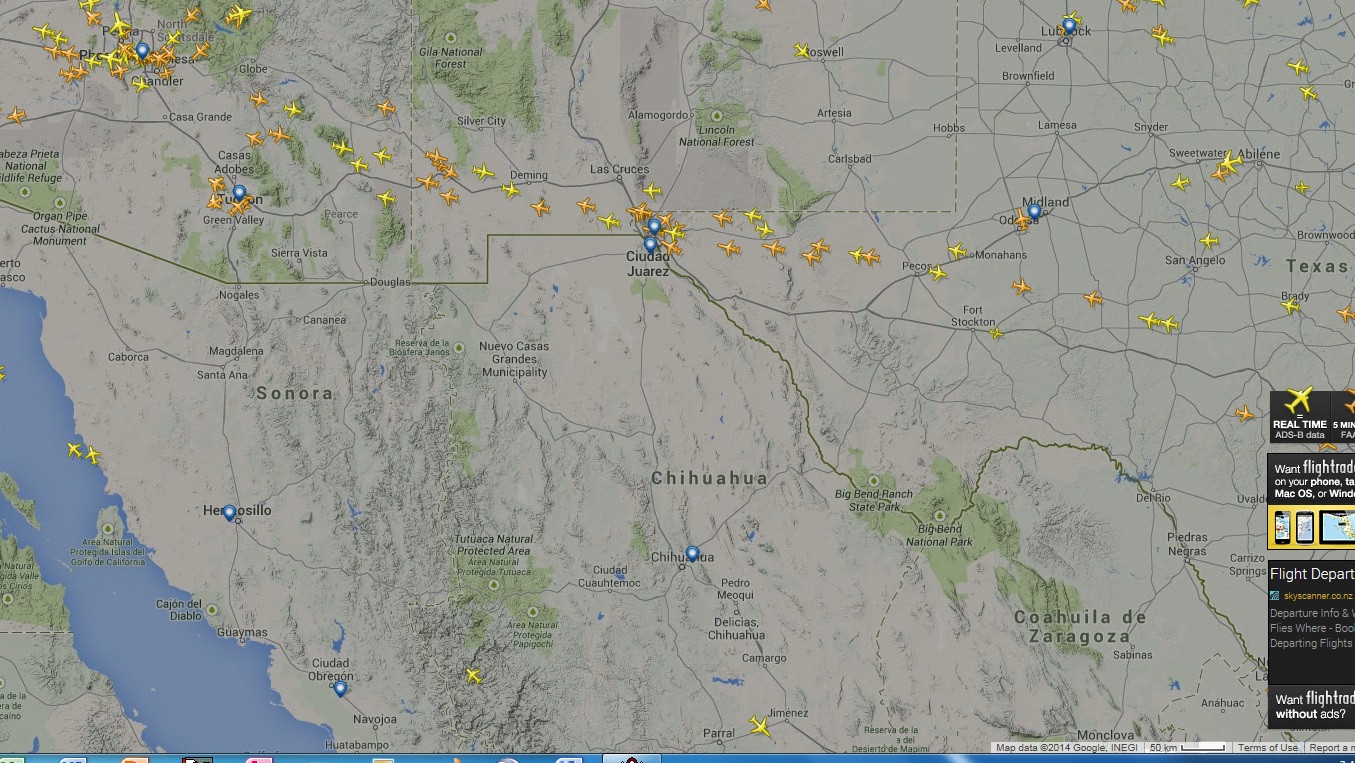
Not sure what you are perceiving here (perhaps missing where the Border between the US and Mexico is). This traffic you have shown is at least 125 miles north of that border
Words and numbers don't mean what you seem to think they do. Take another look.
I-10 heading east from Tucson never goes more than 80 miles north of the border. The FR 24 shot shows a plane south of I-10 near where you claim to be in a 'no fly zone'.
A plane?. There are many military PLANES fly over this area; C130s photographing, as part of homeland security; COMMON occurances; but are not on commercial flight paths.
a reply to: vethumanbeing
Military planes won't show up on FR24. People have already posted several COMMERCIAL flights, with flight numbers, that have been flying through your supposed no fly zone that strangely isn't marked on aeronautical charts.
Military planes won't show up on FR24. People have already posted several COMMERCIAL flights, with flight numbers, that have been flying through your supposed no fly zone that strangely isn't marked on aeronautical charts.
originally posted by: DenyObfuscation
a reply to: vethumanbeing
Not over my area. This is a no fly zone (as in military airspace takes priority over commercial), 60 miles from the Mexico border, this is a huge homeland security ZONE. Commercial aircraft fly routes would be at least 80 miles to the north and not visible (or their contrails).
Yes over your area. American Airlines doesn't recognize your 'no fly zone' decree. Are you just making it up as you go?
This plane is about 80 miles east of Davis-Monthan AFB and about 60 miles north of Mexico.
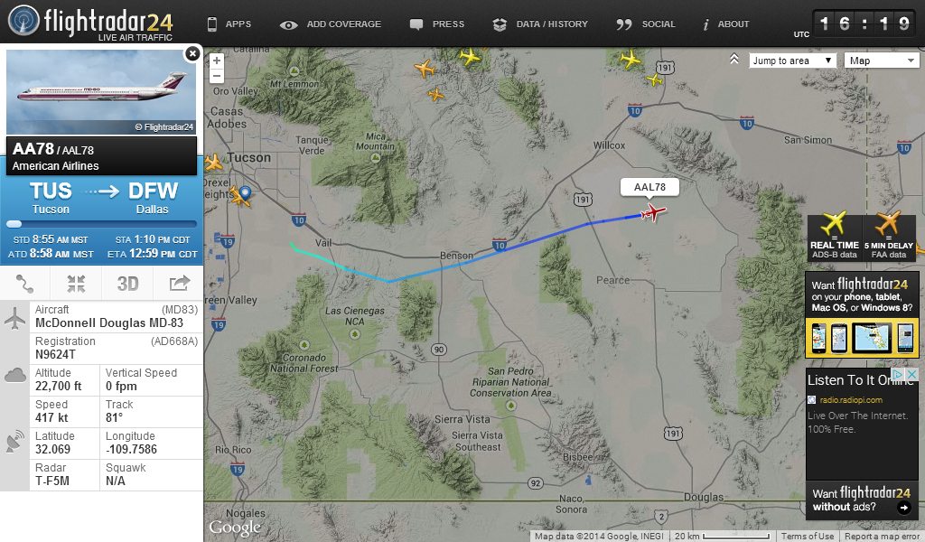
There is no commercial airport in that vicinity of Vail that supports a runway long enough for this type of aircraft. If there is, what is its name and is it an invisible "cheaper" solution to its competitor; Tucson International.
a reply to: vethumanbeing
Why Sonora? Who said anything about Sonora?
From what farm or tin shack in Sonora Mexico?
Why Sonora? Who said anything about Sonora?
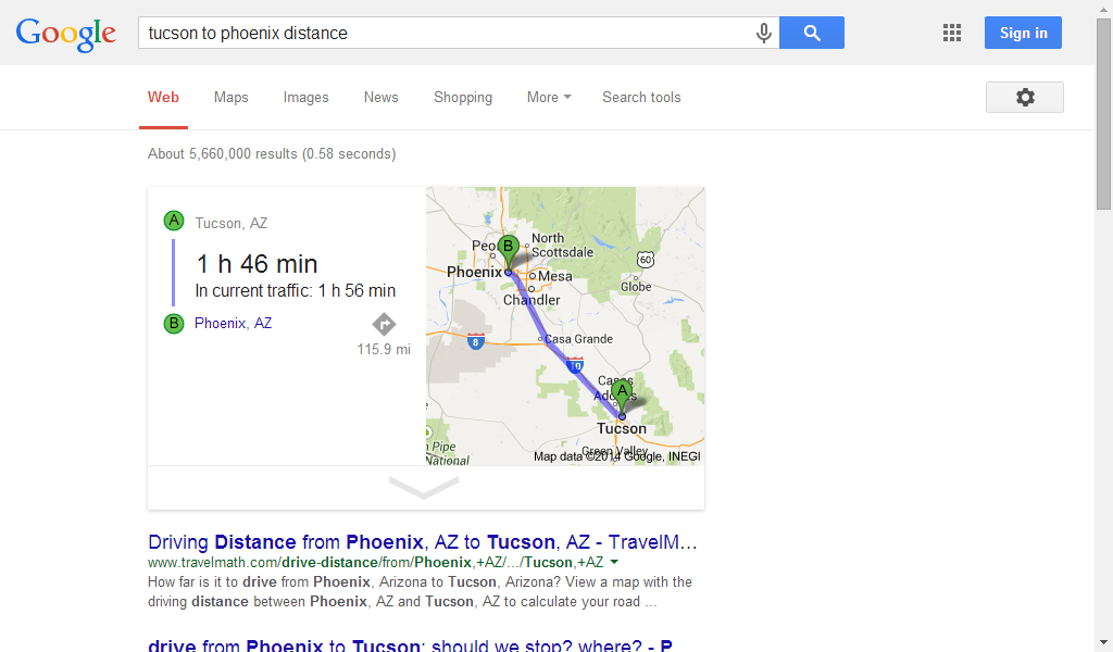
Please clarify that. Phoenix is northeast of which, Tucson or Sonora?
Why would it fly towards Tucson, Phoenix is to the northeast
originally posted by: Rob48
a reply to: vethumanbeing
Military planes won't show up on FR24. People have already posted several COMMERCIAL flights, with flight numbers, that have been flying through your supposed no fly zone that strangely isn't marked on aeronautical charts.
Flight paths are what they are, unless there is a new Dubai somewhere again (invisible) south of the border. No reason to be flying north from that area of Mexico towards Phoenix, as THERE IS NOTHING THERE TO BE flying from.
a reply to: vethumanbeing
Can you read the screenshot from FR 24?
There is no commercial airport in that vicinity of Vail that supports a runway long enough for this type of aircraft. If there is, what is its name and is it an invisible "cheaper" solution to its competitor; Tucson International.
Can you read the screenshot from FR 24?
originally posted by: DenyObfuscation
a reply to: vethumanbeing
From what farm or tin shack in Sonora Mexico?
Why Sonora? Who said anything about Sonora?
Please clarify that. Phoenix is northeast of which, Tucson or Sonora?
Why would it fly towards Tucson, Phoenix is to the northeast
Mexico has 4 (states); like Canada (wherein are called provinces). Sonora is the western edge that is below Arizona/New Mexico. Chihuahua boundry starts below Texas. Phoenix is due northwest 35? degrees of Tucson. Sonora Mexico is not developed by any stretch of the imagination. Could not tell you what that states capitol is and definitely not a tourist destination like the Yucatan would be.
edit on 3-7-2014 by vethumanbeing
because: (no reason given)
originally posted by: vethumanbeing
Mexico has 4 (states); like Canada (wherein are called provinces)...
Mexico has 31 states (plus Mexico City FD, or "Federal District", which is akin to Washington DC).
originally posted by: DenyObfuscation
a reply to: vethumanbeing
There is no commercial airport in that vicinity of Vail that supports a runway long enough for this type of aircraft. If there is, what is its name and is it an invisible "cheaper" solution to its competitor; Tucson International.
Can you read the screenshot from FR 24?
Sure, (the take off or beginning of its journey) starts out light blue then progresses to a deeper blue (flight path) . There is no airport in that area of Vail, and commercial planes do not travel above I10 eastbound; that's for automobiles and would be very distracting to drivers. Why would a rogue plane deviate; Normal flight paths used have been in existence for decades.
edit on 3-7-2014 by vethumanbeing because: (no reason
given)
originally posted by: vethumanbeing
...and commercial planes do not travel above I10 eastbound; that's for automobiles and would be very distracting to drivers.
Now I know you are simply pulling our legs.
Really?? Are you serious when you say planes don't fly above interstates highways (such as I-10) because it would be distracting to drivers? I've seen many, many, many planes while I have driven on interstates.
edit on 7/3/2014 by Soylent Green Is People because: (no reason given)
a reply to: vethumanbeing
Do you not understand? Planes can be overflying you en route to or from locations THOUSANDS of miles away.
A couple of days ago I posted a picture of a Delta plane from JFK to Brussels (Belgium) flying directly over my house in England and leaving a trail. Or the Dreamliner flying over London and leaving a trail from one horizon to the other, which was going from Amsterdam to Curaçao in the Caribbean?
Why are you looking at the LOCAL picture? Passenger planes can cover just about half of the globe in one hop.
edit on 3-7-2014 by Rob48
because: (no reason given)
originally posted by: Soylent Green Is People
originally posted by: vethumanbeing
Mexico has 4 (states); like Canada (wherein are called provinces)...
Mexico has 31 states (plus Mexico City FD, or "Federal District", which is akin to Washington DC).
4 major that really matter as territories, as in regional cuisine profiles, why quibble about the other 27 that don't matter. We are talking fish tacos.
edit on 3-7-2014 by vethumanbeing because: (no reason given)
originally posted by: Soylent Green Is People
originally posted by: vethumanbeing
...and commercial planes do not travel above I10 eastbound; that's for automobiles and would be very distracting to drivers.
Now I know you are simply pulling our legs.
Really?? Planes don't fly above interstates highways (such as I-10) because it would be distracting to drivers? I've seen many, many, many planes while I have driven on interstates.
Collect the names, because some air traffic controllers either need a vacation in Sonora or should be arrested for not seeing "auto Pilot" is malfunctioning. You have no idea the chem trail problem we have here in AZ, (back to the real focus of the thread).
originally posted by: vethumanbeing
originally posted by: Soylent Green Is People
originally posted by: vethumanbeing
...and commercial planes do not travel above I10 eastbound; that's for automobiles and would be very distracting to drivers.
Now I know you are simply pulling our legs.
Really?? Planes don't fly above interstates highways (such as I-10) because it would be distracting to drivers? I've seen many, many, many planes while I have driven on interstates.
Collect the names, because some air traffic controllers either need a vacation in Sonora or should be arrested for not seeing "auto Pilot" is malfunctioning. You have no idea the chem trail problem we have here in AZ, (back to the real focus of the thread).
Yes, back to the focus of the thread.
Tell me, how many chemtrails have you seen in the sunny skies of AZ today?
I'm going to wager that the answer is 0, zip, none, niente, nada.
Ask me how I know this. And if I'm wrong, prove it, with a verifiable, dated photograph.
edit on 3-7-2014 by Rob48 because: (no reason
given)
originally posted by: Rob48
a reply to: veteranhumanbeing
Not 60 miles from the Mexico Border South in Arizona (home land security) .gov doesn't need commercial airlines flying over this region, it has too many military aircraft eyes in the skies already and believe me doesn't need a lumbering gawky Boeing 777 coming out of Sauarita 50 miles south of the border headed for Tucson in this airspace. It would normally be rerouted to Juarez/El Paso for a layover, then on to Dallas Hub then to Phoenix or the North Pole. Why would known flight paths change; there is "the shortest route possible" rule, saving time; fuel and wear and tear on the planes. The pictures were posted, by you folks, hard to argue with what those fight paths indicate: A PATTERN.
a reply to: veteranhumanbeing
[I]Rob48[/I]Do you not understand? Planes can be overflying you en route to or from locations THOUSANDS of miles away.
Not 60 miles from the Mexico Border South in Arizona (home land security) .gov doesn't need commercial airlines flying over this region, it has too many military aircraft eyes in the skies already and believe me doesn't need a lumbering gawky Boeing 777 coming out of Sauarita 50 miles south of the border headed for Tucson in this airspace. It would normally be rerouted to Juarez/El Paso for a layover, then on to Dallas Hub then to Phoenix or the North Pole. Why would known flight paths change; there is "the shortest route possible" rule, saving time; fuel and wear and tear on the planes. The pictures were posted, by you folks, hard to argue with what those fight paths indicate: A PATTERN.
edit on 3-7-2014 by vethumanbeing because:
(no reason given)
originally posted by: Rob48
None, we don't have commercial jet aircraft flying over this area so no vapor contrails ever to be seen or engines heard. I'm speaking of an anomaly that is entirely different that involves 'other aircraft' flying much lower.
[I]Rob[/I]Tell me, how many chemtrails have you seen in the sunny skies of AZ today?
I'm going to wager that the answer is 0, zip, none, niente, nada.
Ask me how I know this. And if I'm wrong, prove it, with a verifiable, dated photograph.
None, we don't have commercial jet aircraft flying over this area so no vapor contrails ever to be seen or engines heard. I'm speaking of an anomaly that is entirely different that involves 'other aircraft' flying much lower.
edit on 3-7-2014 by vethumanbeing because: (no reason
given)
a reply to: vethumanbeing
Why would a flight going over Tucson have to originate FROM Tucson?
Last time I checked there was quite a lot of land north of Arizona. Do they have aircraft in Canada these days? Do they fly to Mexico? How about South America?
If planes from Holland to the Caribbean, or New York to Belgium, are flying over my house, what makes you think all the planes over you are local? Some of them probably don't take off or land anywhere in the USA!
a reply to: vethumanbeing
Maybe the pilot is messing around. Maybe he's seeing how much he can get away with. Maybe he's just a deviant. It's hard to know for sure with no reliable information to go on.
Why would a rogue plane deviate
new topics
-
whistleblower Captain Bill Uhouse on the Kingman UFO recovery
Aliens and UFOs: 3 hours ago -
1980s Arcade
General Chit Chat: 5 hours ago -
Deadpool and Wolverine
Movies: 6 hours ago -
Teenager makes chess history becoming the youngest challenger for the world championship crown
Other Current Events: 7 hours ago -
CIA botched its handling of sexual assault allegations, House intel report says
Breaking Alternative News: 8 hours ago -
Lawsuit Seeks to ‘Ban the Jab’ in Florida
Diseases and Pandemics: 10 hours ago
top topics
-
Lawsuit Seeks to ‘Ban the Jab’ in Florida
Diseases and Pandemics: 10 hours ago, 20 flags -
Starburst galaxy M82 - Webb Vs Hubble
Space Exploration: 12 hours ago, 12 flags -
CIA botched its handling of sexual assault allegations, House intel report says
Breaking Alternative News: 8 hours ago, 8 flags -
The Superstition of Full Moons Filling Hospitals Turns Out To Be True!
Medical Issues & Conspiracies: 14 hours ago, 8 flags -
IDF Intel Chief Resigns Over Hamas attack
Middle East Issues: 17 hours ago, 6 flags -
whistleblower Captain Bill Uhouse on the Kingman UFO recovery
Aliens and UFOs: 3 hours ago, 6 flags -
15 Unhealthiest Sodas On The Market
Health & Wellness: 12 hours ago, 5 flags -
Teenager makes chess history becoming the youngest challenger for the world championship crown
Other Current Events: 7 hours ago, 3 flags -
Deadpool and Wolverine
Movies: 6 hours ago, 3 flags -
1980s Arcade
General Chit Chat: 5 hours ago, 3 flags
active topics
-
How ageing is" immune deficiency"
Medical Issues & Conspiracies • 26 • : RookQueen2 -
The Democrats Take Control the House - Look what happened while you were sleeping
US Political Madness • 105 • : SchrodingersRat -
Starburst galaxy M82 - Webb Vs Hubble
Space Exploration • 4 • : SchrodingersRat -
Non-Human Operate Within The Visual Spectrum 'We Cannot See' - ULTRATERRESTRIALS EXIST!
Paranormal Studies • 136 • : burritocat -
New whistleblower Jason Sands speaks on Twitter Spaces last night.
Aliens and UFOs • 39 • : RookQueen2 -
23,000 Dead People Registered Within a Two Week Period In One State
US Political Madness • 39 • : Audreagassulke -
1980s Arcade
General Chit Chat • 7 • : Freeborn -
Europe declares war on Russia?
World War Three • 59 • : Freeborn -
George Knapp AMA on DI
Area 51 and other Facilities • 38 • : theshadowknows -
Candidate TRUMP Now Has Crazy Judge JUAN MERCHAN After Him - The Stormy Daniels Hush-Money Case.
Political Conspiracies • 618 • : WeMustCare