It looks like you're using an Ad Blocker.
Please white-list or disable AboveTopSecret.com in your ad-blocking tool.
Thank you.
Some features of ATS will be disabled while you continue to use an ad-blocker.

Firefighter chases dog and both are missing 411?
page: 49share:
a reply to: EyesOpenMouthShut
concerning that missing person in Colorado.
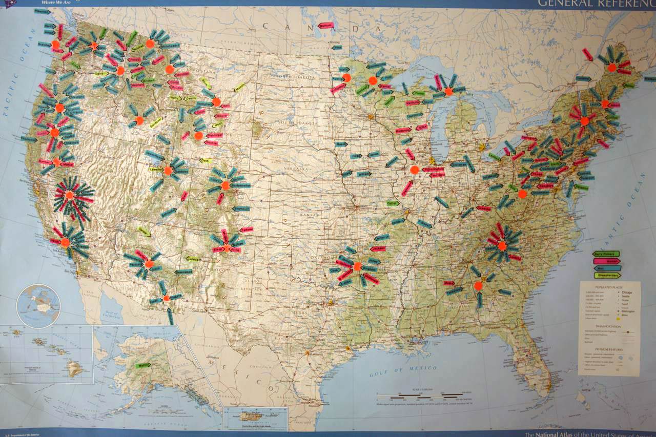
the place she went missing from looks to be in line with a cluster point David has illustrated in this map for northern colorado.....
probably not a good sign
concerning that missing person in Colorado.
the place she went missing from looks to be in line with a cluster point David has illustrated in this map for northern colorado.....
probably not a good sign
As the days have passed, and I’ve revisited the data & varieties of reports again & again, I have grown less convinced of the conclusion
(as to where the body was found).
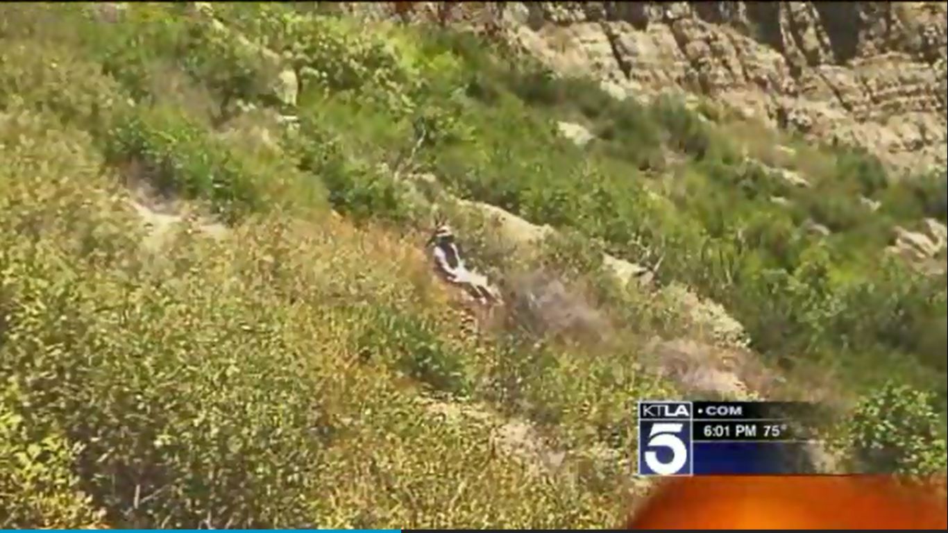
Primarily because of this photo…
I can find no exif data on said photo to verify when it was taken…but KTLA attributed said photo to the Ventura County Sheriff’s department…
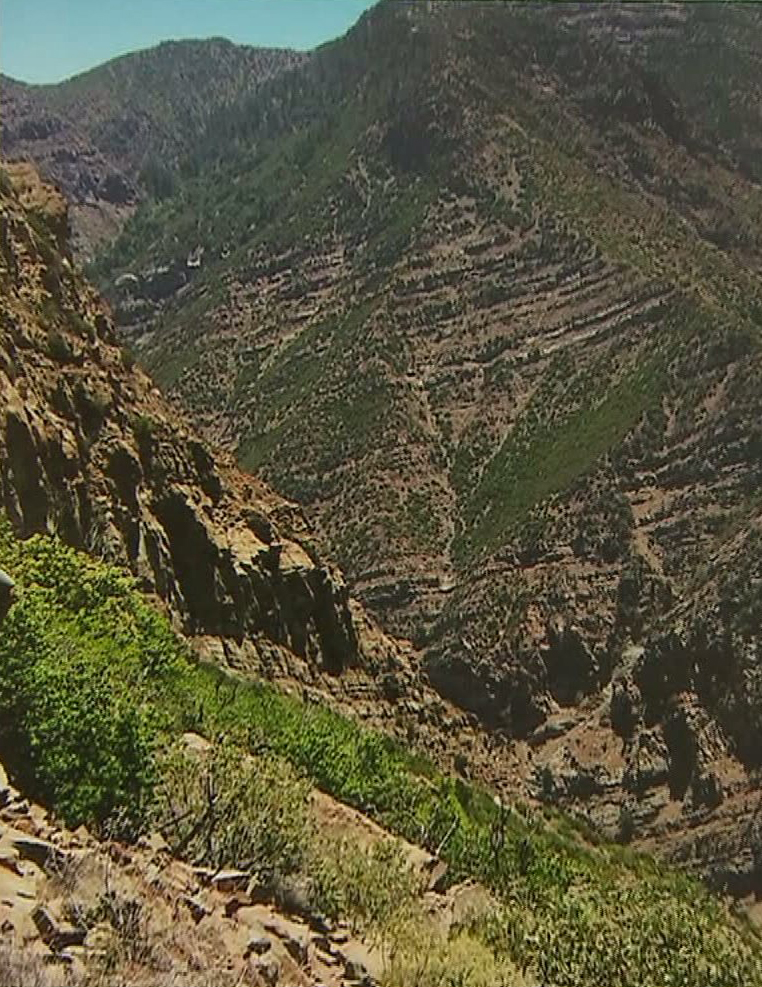
ATS Big Pic
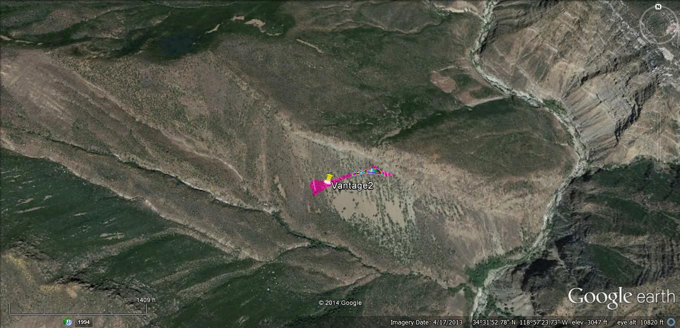
Below is virtually, the only way to get the view shown in this photo from Google Earth…
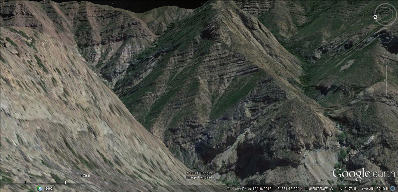
ATS Big Pic
If this pic’ was taken in the vicinity of where the body was found…then, this is nearly 2 miles from what was presumed as the “Possible Campsite”.
Note that the vantage of the above GE image is from somewhere around the spot marked “Vantage2” on the following GE image, facing ESE:
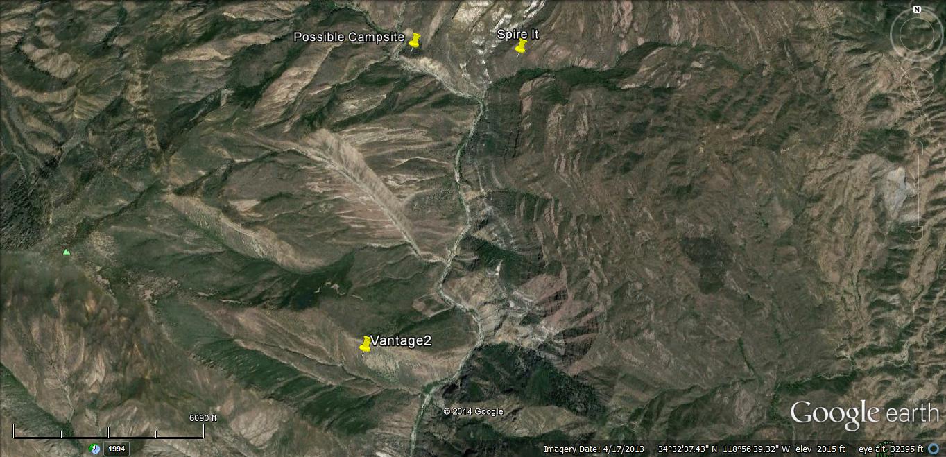
ATS Big Pic
Unlike the terrain of the proposed “body-location” in the previous post that regarded the “Spire”, it would not be difficult to climb straight from the river bottom to anywhere along this “slope”… So – if this is “where” the Sheriff was talking about – I gotta wonder what he was smoking that day.
With all the jumble of information that we’re having to sift through, and contend with…I am seriously wondering if we can make a group/concerted effort at gaining access to the records available through California’s Public Records Act…and have done a bit of research regarding the same…as follows:
(from Wikipedia…)
“California Proposition 59 (2004)
“On November 2, 2004, California voters overwhelmingly approved Proposition 59. Commonly called the Sunshine Amendment, it added Article 1, Section 3(b) to the California Constitution, which reads in part:
“The people have the right of access to information concerning the conduct of the people’s business, and, therefore, the meetings of public bodies and the writings of public officials and agencies shall be open to public scrutiny.”
“In September 2013 the legislature approved a constitutional amendment, authored by state senator Mark Leno, which would further incorporate the Public Records Act into the California State Constitution. The amendment clarifies that local governments must comply with requests for publicly available documents, and requires local governments to pay the costs of those requests in full. The proposed amendment will go to the voters for approval in June 2014.”
“This was known as Proposition 42 on the June 3, 2014 ballot…and passed with 61.84% ‘Yes’ votes, and 38.16% ‘No’ votes…
You can read a ballotpedia.org-brief…here
Since the case of Mike Herdman has been called an accident (no foul play), one would expect that the records related to said investigation…would be available under this amendment to the California State Constitution.
I would hope/expect that someone living in California could confirm/determine if the records of this investigation are thus, available for request…
If they are available only to California residents… … …
When it says that the governmental institutions are responsible for all costs…I would like clarification on that, as well…
Any Californians?
Any takers?
I am willing to donate to the cause.
Primarily because of this photo…
I can find no exif data on said photo to verify when it was taken…but KTLA attributed said photo to the Ventura County Sheriff’s department…
ATS Big Pic
Below is virtually, the only way to get the view shown in this photo from Google Earth…
ATS Big Pic
If this pic’ was taken in the vicinity of where the body was found…then, this is nearly 2 miles from what was presumed as the “Possible Campsite”.
Note that the vantage of the above GE image is from somewhere around the spot marked “Vantage2” on the following GE image, facing ESE:
ATS Big Pic
Unlike the terrain of the proposed “body-location” in the previous post that regarded the “Spire”, it would not be difficult to climb straight from the river bottom to anywhere along this “slope”… So – if this is “where” the Sheriff was talking about – I gotta wonder what he was smoking that day.
With all the jumble of information that we’re having to sift through, and contend with…I am seriously wondering if we can make a group/concerted effort at gaining access to the records available through California’s Public Records Act…and have done a bit of research regarding the same…as follows:
(from Wikipedia…)
“California Proposition 59 (2004)
“On November 2, 2004, California voters overwhelmingly approved Proposition 59. Commonly called the Sunshine Amendment, it added Article 1, Section 3(b) to the California Constitution, which reads in part:
“The people have the right of access to information concerning the conduct of the people’s business, and, therefore, the meetings of public bodies and the writings of public officials and agencies shall be open to public scrutiny.”
“In September 2013 the legislature approved a constitutional amendment, authored by state senator Mark Leno, which would further incorporate the Public Records Act into the California State Constitution. The amendment clarifies that local governments must comply with requests for publicly available documents, and requires local governments to pay the costs of those requests in full. The proposed amendment will go to the voters for approval in June 2014.”
“This was known as Proposition 42 on the June 3, 2014 ballot…and passed with 61.84% ‘Yes’ votes, and 38.16% ‘No’ votes…
You can read a ballotpedia.org-brief…here
Since the case of Mike Herdman has been called an accident (no foul play), one would expect that the records related to said investigation…would be available under this amendment to the California State Constitution.
I would hope/expect that someone living in California could confirm/determine if the records of this investigation are thus, available for request…
If they are available only to California residents… … …
When it says that the governmental institutions are responsible for all costs…I would like clarification on that, as well…
Any Californians?
Any takers?
I am willing to donate to the cause.
a reply to: WanDash
This is one of those things that really needs to be physically seen and if i lived in california i would go find this location and see if i could climb my rear up there and get a pic along with a few pics of the "campsite" and the area leading up to the location. but, you guys aren't that lucky...
This is one of those things that really needs to be physically seen and if i lived in california i would go find this location and see if i could climb my rear up there and get a pic along with a few pics of the "campsite" and the area leading up to the location. but, you guys aren't that lucky...
From the Coast to Coast AM website:
First Hour: David Paulides, a former lawman turned investigative journalist, talks about unexplained disappearances in National Parks, and his new petition to make the Interior Dept. accountable in these cases.
First Hour: David Paulides, a former lawman turned investigative journalist, talks about unexplained disappearances in National Parks, and his new petition to make the Interior Dept. accountable in these cases.
a reply to: WanDash
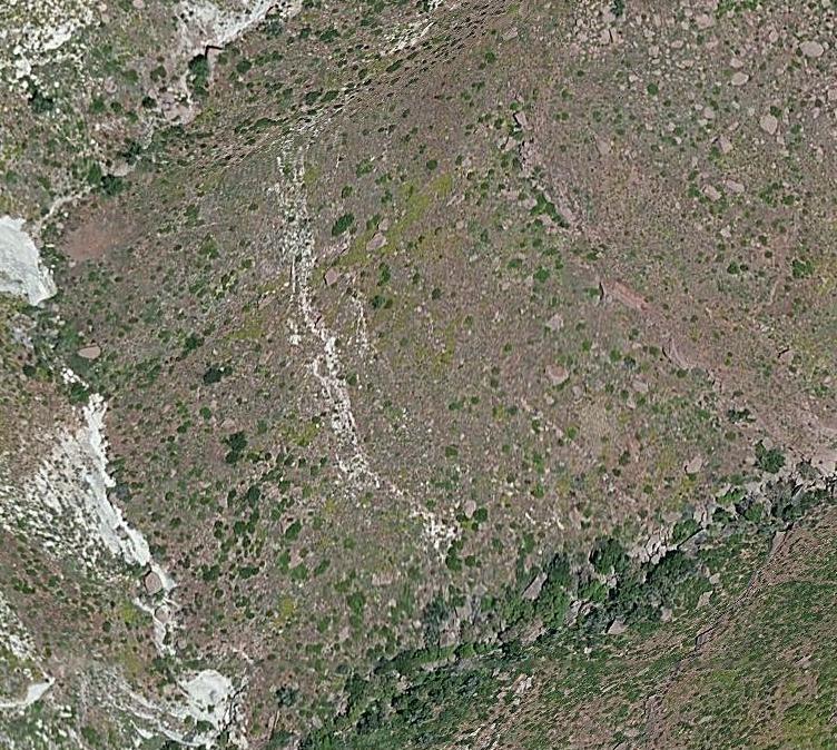
I have confirmed that the first picture in the post that this post is replying to, is where the Sheriff's department claims the body to have been found...
As you can see in the picture, below, the long rock/boulder beside the deputy, is the same rock/boulder as is shown in the lower portion of the referenced "first picture"...
ATS Big Pic
With this being the case, the location of the campsite would need to have been further south along the Sespe Creek, to fall within 3/4 mile...
The place-mark in the previous Google Earth image - "Vantage2" should be within a couple hundred feet of 'where' the body was found.
I have not been able to identify the long rock/boulder in the Google Earth imagery.
Again, though, I will note that I don't get the Sheriff's comments on how/why this would have been a treacherous climb...(except, perhaps, the rock-face at the top...if, indeed, he even tried that). It is just as likely that he could have come up the 'back'/north side, which would have been less strenuous.
In any case, this makes the "spire" less conspicuous - so - sorry for wasting your time with that escapade.
a reply to: [post=18349639]diggindirt[/pos
was just at david paulides site didn't see anything on that missing lady BUT posted is a petition someone started to get the national parks to divulge info about their missing people. see link below
www.canammissing.com...
was just at david paulides site didn't see anything on that missing lady BUT posted is a petition someone started to get the national parks to divulge info about their missing people. see link below
www.canammissing.com...
Just tossing this out there. It was posted today.
Juneau Alaska Mount Roberts Bigfoot Sighting Breakdown
Published on Aug 27, 2014
www.youtube.com...
Juneau Alaska Mount Roberts Bigfoot Sighting Breakdown
Published on Aug 27, 2014
www.youtube.com...
While you don't care...I will explain that the former "Possible Campsite" location had been pointed to in this thread...with no source for the
location given, but simply a link to the coordinates and an explanation that someone had worked-out, from the maps/topographical-maps shown in
the S&R videos...that this was the likely place for the campsite...
Since it was in the general vicinity of where another poster had pointed-to as the area where Duke had been spotted (1 to 1.5 miles north to northwest of Sulfur Peak)...I believed it was probably accurate (since, likewise, some external sources stated that Duke had been seen near the creek, and near the campsite)...
Nonetheless... ... ... ...
With a margin of 50'+/- from the creek bottom, I have outlined/colored-in-violet the area that the body must have been found (that correlates with the two images shown in recent posts)...here -- (with the most likely swath being rainbow colored)
The creek/river bottom at the foot of this climb (to what is designated "Vantage2") records at ~1,700', more or less...
It is less than 1/2 mile 'down' to the creek bottom on the side of the 'cliff' that the body was apparently found...
So - we can, with some degree of confidence, assume that the campsite was not straight down the incline...but, probably further north along the creek...
How far...we don't know...
We could guess...and might be 'right'...but, what's the use...now...?
The foot prints found were supposedly headed south along the creek...and, if Herdman didn't set out, immediately, up the mountainside, the next opportunity to ascend...would have been at or around the ~1,700' creek elevation...
Assuming that he did take this route up the mountainside...and had arrived at the cliff...I have to wonder 'why' he would have chosen to try and climb the rockface, where he *must* have...to have fallen to where the body was found...
There were numerous other ascents that would have been FAR less treacherous...
If he did try to climb the rockface...it would probably have been to get a better vantage for everything on both sides of the ridge...so...why choose one of the worst places to climb?
Another 800-or-so feet would have given him a much easier climb...
So - while I can see some reasons that justify/explain such an ascent, and...can see him doing so, looking for Duke...
I don't see him trying to climb the cliff (or - not where we are led to believe that he did)...without other factors playing into the scheme.
Conversely - if he ascended from the back/north side - I see no reason/justification for him falling to his death ------- unassisted.
edit on
8/29/2014 by WanDash because: tense
edit on 8/29/2014 by WanDash because: unicorns
a reply to: RUFFREADY
At first I had to wonder if Ruff might posting bait?
But then with no concern that a bush could grow out
of solid rock. And while noticing that this isn't the
only location on the rock that isn't reflecting light?
I'm now convinced.
Care to cop a plea Ruff
a reply to: WanDash
Above all, in this thread your work commands respect and
what you're trying to accomplish with only images of this terrain.
Where so much looks the same over and over again. Not an easy task
my man.
But now maybe you can pause on that for a few posts. I have almost
completely ignored referrencing the spire anomaly at all. Because the
amount of oddness already perceived. If you will, not being to big a
hassle? And if so just say no, or not now maybe later. Your choice
NP. But I was hoping you would take some time to recap, what you've
found going on with this and bring the info up to speed? I admit, I'm
not even sure I know the first bit about this. Aside from knowing
something has your attention.
edit on Rpm82914v042014u12 by randyvs because: (no reason given)
@wandan
I'm having trouble getting GE installed at the moment so decided to use MS's Bing Maps. I was interested in the spire thingy
Bing seems to have slightly better images. The image above is the area that you suggested for the spire. There doesn't appear to be anything in the picture that could account for the spire.
Thats some great work you've posted above Studying it now.
I agree we need to access the data for this case
I dont know anything about it other than whats been posted in this thread. I used wandans pictures to locate the area via the bing maps and as you can see there doesn't appear to be anything there, at least nothing visible!
originally posted by: randyvs
a reply to: VoidHawk
What all do you know about the spire thing a ma bob Void?
Amazing difference in quality imaging I agree.
I assume they use some kind of radar for getting elevation readings, and I wonder if the software might be misinterpreting what it see's. I wonder if the software is trying to make sense of an odd reading and is inverting it, if so that would mean its not a spire, but a deep hole? Maybe one of those rocks is hiding something?
originally posted by: VoidHawk
@wandan
I'm having trouble getting GE installed at the moment so decided to use MS's Bing Maps. I was interested in the spire thingy
Bing seems to have slightly better images. The image above is the area that you suggested for the spire. There doesn't appear to be anything in the picture that could account for the spire.
Thats some great work you've posted above Studying it now.
I agree we need to access the data for this case
Thanks, [iVoidHawk
Your image is just short by about 25'...as shown in the image, below...
ATS Big Pic
Am being pulled in numerous directions, at the moment...
Will see if I can get back to this immediately... Otherwise - will do so, later.
Thanks.
BTW - I've looked at the Bing maps...and could not zoom in on the area in question.
On Google Maps...I faced a similar problem - but was able to see the "swirly confusion" at the Spire location in the form of a 'sphere'...
I will present a few images, shortly, that seem to suggest that this is, indeed an 'above-ground' structure...
edit on 8/29/2014 by WanDash
because: More thoughts
a reply to: randyvs
Thanks for your kindness - randyvs!
What do I have on the spire?
Nada...
I have been studying Google Earth imagery intensely since early 2009, and less intensively for a number of years before that.
The only thing I've ever seen similar, was in the ocean...and - no way to verify or validate such 'anomalous' structures there, as the imagery that shows something like this, is usually only in one date-stamped image.
As I have stated, however, this structure is represented with the same dimensions & location in every image Google Earth shows of this location, since 1994.
I would wager that something is...there...
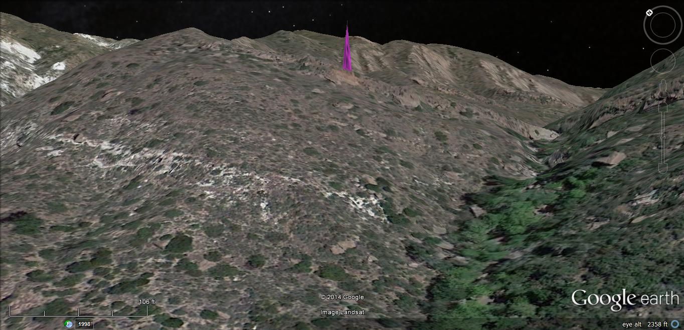
If you go to other vantages...such as to the Sespe Creek/River bottom...you can see its top...
In other words - it is not just visible in Google Earth...from the immediate vicinity.
As to its physical presence/presentation...
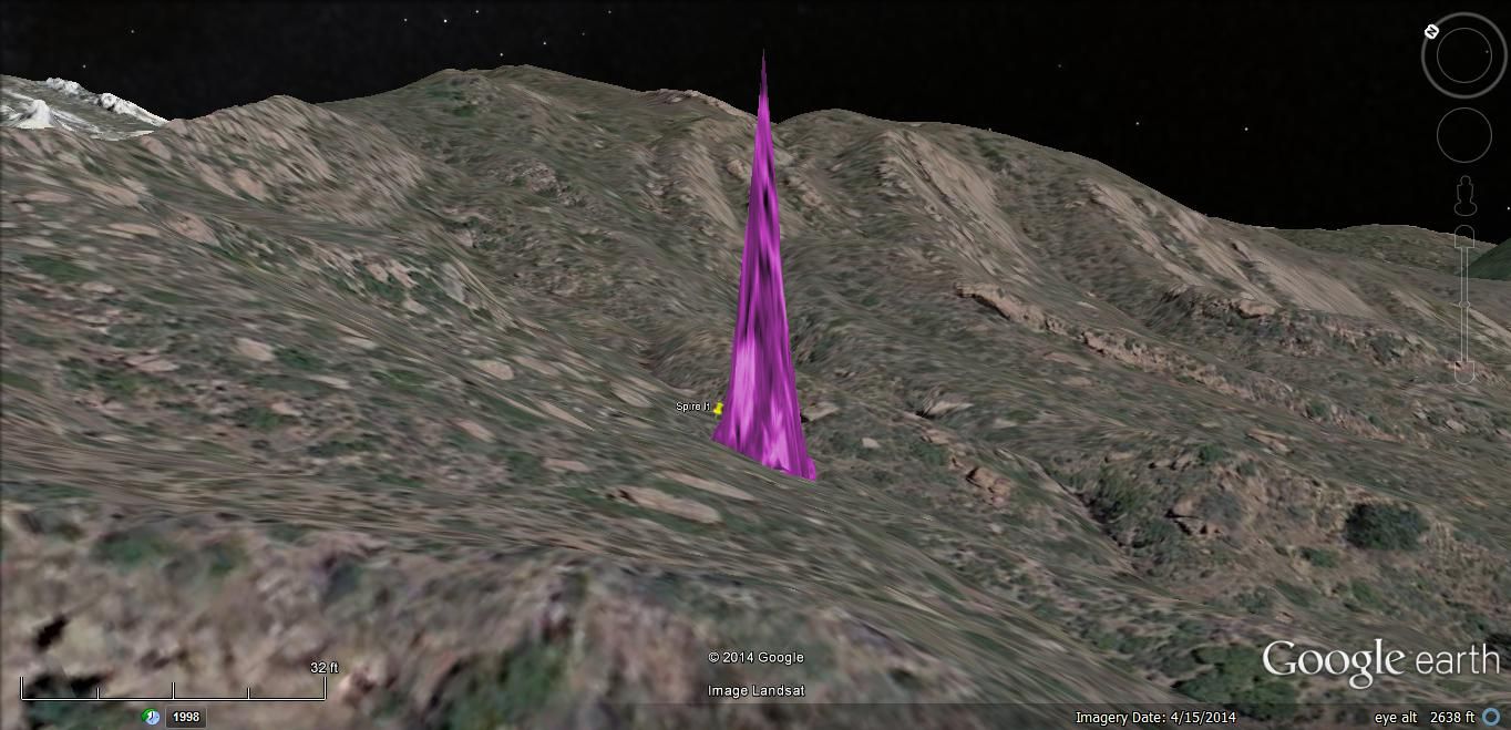
Its base appears to be ~35' at the widest point...
The 'trunk' appears much as a tree trunk might appear...with what might otherwise be considered "large roots" extending from the southwest, southeast, east, north-northeast, and northwest base extremeties.
From the lowest point (2,599') to its peak (2,824'), it measures 225' in height.
There is a 'ditch' of sorts that surrounds this spire...
The ditch does not appear to have accumulated much debris or rock...
This 'ditch' presents the question - "did the spire emerge/erupt from below - was it embedded from above - was it carved/whittled/formed from an existing protrusion... ? ...?"...
As to my thoughts on the spire... They span from:
"One amazing geologic anomaly that should be featured in National Geographic's many publications"
-to-
"a portal that heretofore unknown beings use to step between worlds/dimensions/etc..."
-to-
"an ancient temple whose guardian/s continue to maintain viciously"
-to-
"an extraterrestrial antenna"...
...etc...
... et al ...
Do I continue to suspect that this had something to do with the mystery of Duke & Herdman (and Byars)...?
Yes...
But - it is only suspicion, at this time.
Thanks for your kindness - randyvs!
What do I have on the spire?
Nada...
I have been studying Google Earth imagery intensely since early 2009, and less intensively for a number of years before that.
The only thing I've ever seen similar, was in the ocean...and - no way to verify or validate such 'anomalous' structures there, as the imagery that shows something like this, is usually only in one date-stamped image.
As I have stated, however, this structure is represented with the same dimensions & location in every image Google Earth shows of this location, since 1994.
I would wager that something is...there...
If you go to other vantages...such as to the Sespe Creek/River bottom...you can see its top...
In other words - it is not just visible in Google Earth...from the immediate vicinity.
As to its physical presence/presentation...
Its base appears to be ~35' at the widest point...
The 'trunk' appears much as a tree trunk might appear...with what might otherwise be considered "large roots" extending from the southwest, southeast, east, north-northeast, and northwest base extremeties.
From the lowest point (2,599') to its peak (2,824'), it measures 225' in height.
There is a 'ditch' of sorts that surrounds this spire...
The ditch does not appear to have accumulated much debris or rock...
This 'ditch' presents the question - "did the spire emerge/erupt from below - was it embedded from above - was it carved/whittled/formed from an existing protrusion... ? ...?"...
As to my thoughts on the spire... They span from:
"One amazing geologic anomaly that should be featured in National Geographic's many publications"
-to-
"a portal that heretofore unknown beings use to step between worlds/dimensions/etc..."
-to-
"an ancient temple whose guardian/s continue to maintain viciously"
-to-
"an extraterrestrial antenna"...
...etc...
... et al ...
Do I continue to suspect that this had something to do with the mystery of Duke & Herdman (and Byars)...?
Yes...
But - it is only suspicion, at this time.
Notice how in these missing cases that people are found dead/alive missing shoes. I asked someone what they thought of this and they responded "Why
do witches go barefoot at all times? ( I presume he meant witches of antiquity) That shoes block the signals from the evil entities ( I presume he
means they live inside the earth). He also noted that first thing in all Alien abductions is to get the human directly on soil, hence car wont start
and human gets out on soil to investigate problem. Once on soil the spirits make humans feet swell so they take off their shoes off. Once the shoes
are off its like a switch to an electrical circuit being made fully made, the spirits have full signal and through it they then have full control
over human ( I presume he meant like hypnosis effect persons mind/will is being remote controlled).
The missing persons phenomenon is interesting and so perplexing that I thought I should share this info as I feel that whatever is making these people vanish is due to something left field of reason.
The missing persons phenomenon is interesting and so perplexing that I thought I should share this info as I feel that whatever is making these people vanish is due to something left field of reason.
a reply to: randyvs
I agree with both of you in considering other explanations.
A deep hole that the software doesn't know how to represent...
As I've stated before - a geo-magnetic vortex/anomaly...
And then...there's also the possibility that it is, indeed, a physical feature of the landscape...
Here are three views from different vantages, of the spire...
1st - from the southwest edge of the shelf it emerges from...
ATS Big Pic
2nd - From Sespe Creek...
ATS Big Pic
3rd - From a ridge to the northwest...
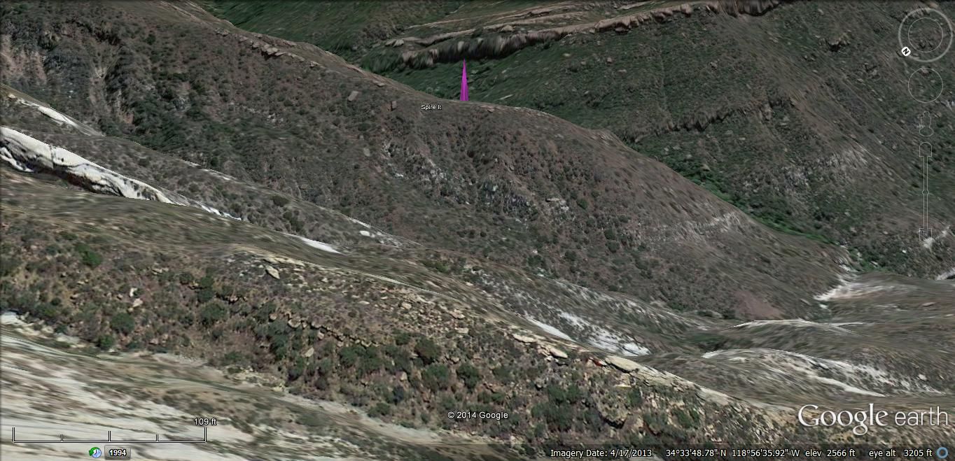
ATS Big Pic
I agree with both of you in considering other explanations.
A deep hole that the software doesn't know how to represent...
As I've stated before - a geo-magnetic vortex/anomaly...
And then...there's also the possibility that it is, indeed, a physical feature of the landscape...
Here are three views from different vantages, of the spire...
1st - from the southwest edge of the shelf it emerges from...
ATS Big Pic
2nd - From Sespe Creek...
ATS Big Pic
3rd - From a ridge to the northwest...
ATS Big Pic
a reply to: WanDash
Just missed it
WanDash, you say the spire is visible on google earth? because its visible on google maps too, but does not show at all on Bing maps. I suspect its unrelated but it is very odd.
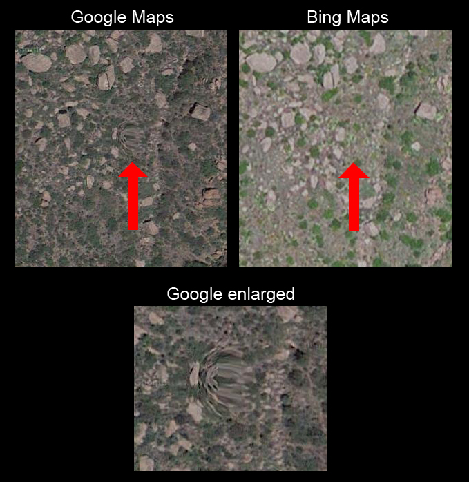
I was wrong about the quality of the images, google is better, though seems prone to strange anomalies!
Just missed it
WanDash, you say the spire is visible on google earth? because its visible on google maps too, but does not show at all on Bing maps. I suspect its unrelated but it is very odd.
I was wrong about the quality of the images, google is better, though seems prone to strange anomalies!
new topics
-
Meadows, Giuliani Among 11 Indicted in Arizona in Latest 2020 Election Subversion Case
Mainstream News: 34 minutes ago -
Massachusetts Drag Queen Leads Young Kids in Free Palestine Chant
Social Issues and Civil Unrest: 49 minutes ago -
Weinstein's conviction overturned
Mainstream News: 2 hours ago -
Supreme Court Oral Arguments 4.25.2024 - Are PRESIDENTS IMMUNE From Later Being Prosecuted.
Above Politics: 3 hours ago -
Krystalnacht on today's most elite Universities?
Social Issues and Civil Unrest: 3 hours ago -
Chris Christie Wishes Death Upon Trump and Ramaswamy
Politicians & People: 4 hours ago -
University of Texas Instantly Shuts Down Anti Israel Protests
Education and Media: 6 hours ago -
Any one suspicious of fever promotions events, major investor Goldman Sachs card only.
The Gray Area: 8 hours ago
top topics
-
VP's Secret Service agent brawls with other agents at Andrews
Mainstream News: 17 hours ago, 11 flags -
Krystalnacht on today's most elite Universities?
Social Issues and Civil Unrest: 3 hours ago, 7 flags -
Weinstein's conviction overturned
Mainstream News: 2 hours ago, 6 flags -
Electrical tricks for saving money
Education and Media: 16 hours ago, 5 flags -
Supreme Court Oral Arguments 4.25.2024 - Are PRESIDENTS IMMUNE From Later Being Prosecuted.
Above Politics: 3 hours ago, 5 flags -
University of Texas Instantly Shuts Down Anti Israel Protests
Education and Media: 6 hours ago, 3 flags -
Massachusetts Drag Queen Leads Young Kids in Free Palestine Chant
Social Issues and Civil Unrest: 49 minutes ago, 2 flags -
Meadows, Giuliani Among 11 Indicted in Arizona in Latest 2020 Election Subversion Case
Mainstream News: 34 minutes ago, 2 flags -
Any one suspicious of fever promotions events, major investor Goldman Sachs card only.
The Gray Area: 8 hours ago, 2 flags -
God's Righteousness is Greater than Our Wrath
Religion, Faith, And Theology: 13 hours ago, 1 flags
active topics
-
Chris Christie Wishes Death Upon Trump and Ramaswamy
Politicians & People • 15 • : diaclonethunder -
Massachusetts Drag Queen Leads Young Kids in Free Palestine Chant
Social Issues and Civil Unrest • 5 • : Texastruth2 -
Candidate TRUMP Now Has Crazy Judge JUAN MERCHAN After Him - The Stormy Daniels Hush-Money Case.
Political Conspiracies • 759 • : xuenchen -
University of Texas Instantly Shuts Down Anti Israel Protests
Education and Media • 142 • : FlyersFan -
Weinstein's conviction overturned
Mainstream News • 16 • : WeMustCare -
VP's Secret Service agent brawls with other agents at Andrews
Mainstream News • 51 • : grey580 -
New whistleblower Jason Sands speaks on Twitter Spaces last night.
Aliens and UFOs • 60 • : baablacksheep1 -
Nearly 70% Of Americans Want Talks To End War In Ukraine
Political Issues • 85 • : Consvoli -
Graham Hancock being proven right all along about ancient humans in America.
Ancient & Lost Civilizations • 106 • : JonnyC555 -
Supreme Court Oral Arguments 4.25.2024 - Are PRESIDENTS IMMUNE From Later Being Prosecuted.
Above Politics • 47 • : matafuchs