It looks like you're using an Ad Blocker.
Please white-list or disable AboveTopSecret.com in your ad-blocking tool.
Thank you.
Some features of ATS will be disabled while you continue to use an ad-blocker.

Alberta Flooding 2014
page: 15
share:
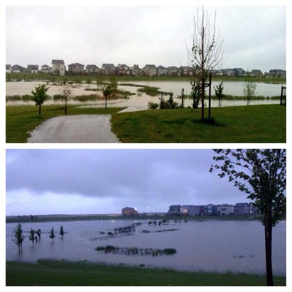
Here we go again. Hopefully our Alberta members stay dry (Yes I mean you Calgarian!)
www.cbc.ca...
www.cbc.ca...
I was hoping that this wasn't going to be a yearly trend...
Environment Canada says a low-pressure system is expected to bring up to 70 millimetres of rain Wednesday in the southwestern foothills before tapering off Thursday morning. The total rainfall in that area may exceed 200 millimetres.
www.cbc.ca...
Alberta's director of river forecasting, Evan Friesenham, said they're predicting a peak flow in the South Saskatchewan River of 5,300 cubic metres per second in Medicine Hat, about the same as in 2013. "Obviously that's a worst-case scenario," he said. "As the storm progresses and we have more information on the ground, we'll be refining forecasts throughout the basin and throughout the southern portion of the province as we go."
www.cbc.ca...
I was hoping that this wasn't going to be a yearly trend...
edit on 18-6-2014 by canucks555 because: (no reason given)
I'm keeping my fingers crossed for everyone in the affected area.
I heard something last night about the Old Man River Dam, but my brain was on pause at that time. Can you clue me in on the connection, if any?
I heard something last night about the Old Man River Dam, but my brain was on pause at that time. Can you clue me in on the connection, if any?
edit on 18-6-2014 by aboutface because: (no reason given)
The Oldman river is supposed to rise by, wait for it...25 to 30 feet above normal.
!!
www.rock106.ca...
!!
Lethbridge County has declared a state of local emergency, saying water levels in the Oldman River are extremely high and could rise to 1995 flood levels. The river may rise 6 meters based on the forecast and the preliminiary operational plans of the dams upstream.
www.rock106.ca...
edit on 18-6-2014 by canucks555 because: (no reason given)
Wow!
Someone quick! Get the drain unplugged!
Hope everyone up there stay's safe, and keeps an eye on things.
Someone quick! Get the drain unplugged!
Hope everyone up there stay's safe, and keeps an eye on things.
Isn't this the area that the Tar Sands are running through/to?
If so, this should SCREAM eco terrorism.
If so, this should SCREAM eco terrorism.
a reply to: ArchPlayer
Nope the danger is mostly in the South West of the province, tar sands are in the North.
Nope the danger is mostly in the South West of the province, tar sands are in the North.
edit on 18-6-2014 by canucks555 because: (no reason
given)
a reply to: ArchPlayer
You may be on to something. I never did trust the Starbucks crowd.
They made it rain, probably by praying to the Starbucks logo.
You may be on to something. I never did trust the Starbucks crowd.
They made it rain, probably by praying to the Starbucks logo.
No this is much father south than the oilsands.
This is what happens when you build/live on a low lying flood plain.
Granted, when they design they take into account that they can deal with about 80 - 90% of the maximum flood levels because the maximum flood levels are only reached a few times every 1/2 decades (supposedly).
They had a few plans they were putting into place, but they take time. and dealing with this two years in a row makes that almost impossible.
new topics
-
Happy St George's day you bigots!
Breaking Alternative News: 53 minutes ago -
TLDR post about ATS and why I love it and hope we all stay together somewhere
General Chit Chat: 1 hours ago -
Hate makes for strange bedfellows
US Political Madness: 3 hours ago -
Who guards the guards
US Political Madness: 6 hours ago -
Has Tesla manipulated data logs to cover up auto pilot crash?
Automotive Discussion: 8 hours ago
top topics
-
Hate makes for strange bedfellows
US Political Madness: 3 hours ago, 14 flags -
whistleblower Captain Bill Uhouse on the Kingman UFO recovery
Aliens and UFOs: 13 hours ago, 10 flags -
Who guards the guards
US Political Madness: 6 hours ago, 10 flags -
1980s Arcade
General Chit Chat: 15 hours ago, 6 flags -
Teenager makes chess history becoming the youngest challenger for the world championship crown
Other Current Events: 17 hours ago, 5 flags -
Deadpool and Wolverine
Movies: 16 hours ago, 4 flags -
TLDR post about ATS and why I love it and hope we all stay together somewhere
General Chit Chat: 1 hours ago, 3 flags -
Has Tesla manipulated data logs to cover up auto pilot crash?
Automotive Discussion: 8 hours ago, 2 flags -
Happy St George's day you bigots!
Breaking Alternative News: 53 minutes ago, 2 flags
active topics
-
Russia Ukraine Update Thread - part 3
World War Three • 5716 • : Oldcarpy2 -
-@TH3WH17ERABB17- -Q- ---TIME TO SHOW THE WORLD--- -Part- --44--
Dissecting Disinformation • 612 • : cherokeetroy -
Candidate TRUMP Now Has Crazy Judge JUAN MERCHAN After Him - The Stormy Daniels Hush-Money Case.
Political Conspiracies • 704 • : Lazy88 -
1980s Arcade
General Chit Chat • 20 • : Drugstorecowboy56 -
Remember These Attacks When President Trump 2.0 Retribution-Justice Commences.
2024 Elections • 42 • : TzarChasm -
15 Unhealthiest Sodas On The Market
Health & Wellness • 39 • : Roma1927 -
Happy St George's day you bigots!
Breaking Alternative News • 9 • : Oldcarpy2 -
whistleblower Captain Bill Uhouse on the Kingman UFO recovery
Aliens and UFOs • 15 • : Mantiss2021 -
UN warns Assange may be tortured if extradited to US
Whistle Blowers and Leaked Documents • 15 • : 5thHead -
MULTIPLE SKYMASTER MESSAGES GOING OUT
World War Three • 98 • : cherokeetroy
5