It looks like you're using an Ad Blocker.
Please white-list or disable AboveTopSecret.com in your ad-blocking tool.
Thank you.
Some features of ATS will be disabled while you continue to use an ad-blocker.

Greenland's Long Glacier Fjords Point to Higher Seas
page: 15
share:
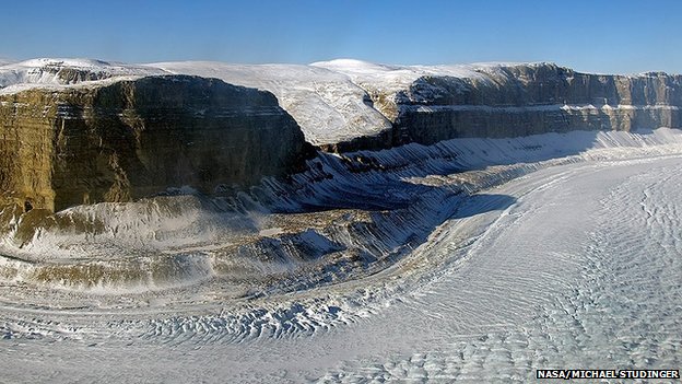
Greenland's ice sheet may be more vulnerable to melting than previously thought, say scientists. A new study has reassessed the shape of the great fjords down which glaciers drain to the ocean. It finds them to be far deeper and to stretch further back inland than was recognised in earlier research.
Dr Mathieu Morlighem told the Nature Geoscience journal that this could expose the glaciers to more prolonged erosion by warm seawaters. "We know that many of these Greenland glaciers are accelerating and that their fronts are retreating because of the action of warmer ocean waters," he said.
"And because we now know these canyons are far longer than we thought, it means the ice forms can retire much further back, before rising on to land where they won't be in contact with the ocean anymore."
The usual way to map the thickness of glaciers and the position of the underlying rockbed is to make surveys with airborne ice-penetrating radar. But acquiring such data sets is both expensive and difficult. Even in those locations where radar has been used, the rugged terrain under the ice can often give a very cluttered picture. And in places where melt water sits on top of the glacier, the radar pulse is simply deflected away from the ice body.
www.bbc.com...
"Older models predicted that these glaciers would soon retreat on to higher ground and would stabilise, and so the contribution to sea-level rise from the Greenland ice sheet would be limited," said Dr Morlighem.
"But the problem is that these models were based on rockbed topography that was not accurate enough. With our new bed topography, we can expect the predictions for the Greenland ice sheet's contribution to sea-level rise to be changed."
The rest of the article explains the methods used to define the topography under the ice.
Here is a video that gives some good information however the topography measurements in the video are based on an older method.
They forgot " appears to" Where I work such words would make you unemployed
edit on 20-5-2014 by mikell because: (no reason given)
Scientists are careful with their words.
If there's a 99% confidence, they'll still often say 'may' or 'might' because it's not an absolute certainty.
Some might be less careful and say 'probably' or even 'expected' - the audacity!
If there's a 99% confidence, they'll still often say 'may' or 'might' because it's not an absolute certainty.
Some might be less careful and say 'probably' or even 'expected' - the audacity!
a reply to: Grimpachi
so I think I understand the situation.
Some people who are using faulty and uncertain techniques to study this glacier think that it might be bigger and/or deeper than they and others used to think it was.
That this difference in their old data (if any) might cause more of the glacier to melt some more than once thought which in turn could possibly raise the sea level an unspecified amount.
Sounds like unsubstanciated (sp) propaganda to furthur an agenda of some sort
Or, just plain filler/fluff.
edit on 20-5-2014 by grubblesnert because: spelling: courtesy of a 70s U.S. High School education
edit on 20-5-2014 by
grubblesnert because: spellin' it's always gonna be.......spellin!!
a reply to: grubblesnert
Well you almost grasped what they were saying.
The mention of uncertain techniques isn't about the ones they are useing but hey maybe at some point there will be even better methods of measuring the topography.
Oh that was the other thing you missed. They are measuring or lets say mapping the "land" underneath the glaciers and not so much the glaciers themselves but at least you put some effort into understanding the article so I give you that. That's a lot more than some have done so far in this thread.
You are right though in a sense that if there are no land barriers to stop the ocean from eating away at the glaciers that does mean that there will be a substantial amount more glacier melt that should be expected.
You can keep your propaganda, agenda, and filler/fluff though as this is really about science. If you can't speak to the science then you are speaking a different language.
new topics
-
Ditching physical money
History: 3 hours ago -
One Flame Throwing Robot Dog for Christmas Please!
Weaponry: 3 hours ago -
Don't take advantage of people just because it seems easy it will backfire
Rant: 3 hours ago -
VirginOfGrand says hello
Introductions: 4 hours ago -
Should Biden Replace Harris With AOC On the 2024 Democrat Ticket?
2024 Elections: 5 hours ago -
University student disciplined after saying veganism is wrong and gender fluidity is stupid
Education and Media: 7 hours ago -
Geddy Lee in Conversation with Alex Lifeson - My Effin’ Life
People: 8 hours ago -
God lived as a Devil Dog.
Short Stories: 9 hours ago -
Police clash with St George’s Day protesters at central London rally
Social Issues and Civil Unrest: 10 hours ago -
TLDR post about ATS and why I love it and hope we all stay together somewhere
General Chit Chat: 11 hours ago
top topics
-
Hate makes for strange bedfellows
US Political Madness: 13 hours ago, 20 flags -
Who guards the guards
US Political Madness: 16 hours ago, 13 flags -
University student disciplined after saying veganism is wrong and gender fluidity is stupid
Education and Media: 7 hours ago, 12 flags -
Police clash with St George’s Day protesters at central London rally
Social Issues and Civil Unrest: 10 hours ago, 9 flags -
TLDR post about ATS and why I love it and hope we all stay together somewhere
General Chit Chat: 11 hours ago, 7 flags -
Should Biden Replace Harris With AOC On the 2024 Democrat Ticket?
2024 Elections: 5 hours ago, 5 flags -
Don't take advantage of people just because it seems easy it will backfire
Rant: 3 hours ago, 4 flags -
One Flame Throwing Robot Dog for Christmas Please!
Weaponry: 3 hours ago, 4 flags -
God lived as a Devil Dog.
Short Stories: 9 hours ago, 3 flags -
Ditching physical money
History: 3 hours ago, 3 flags
active topics
-
British TV Presenter Refuses To Use Guest's Preferred Pronouns
Education and Media • 121 • : Asher47 -
I have accepted I will be single the rest of my days
Relationships • 118 • : seekshelter -
Should Biden Replace Harris With AOC On the 2024 Democrat Ticket?
2024 Elections • 39 • : WeMustCare -
Remember These Attacks When President Trump 2.0 Retribution-Justice Commences.
2024 Elections • 49 • : WeMustCare -
-@TH3WH17ERABB17- -Q- ---TIME TO SHOW THE WORLD--- -Part- --44--
Dissecting Disinformation • 634 • : RookQueen2 -
Ditching physical money
History • 12 • : CataclysmicRockets -
Joe Biden Just Lost A Primary Election To A Man Nobody Heard Of Until A Minute Ago
2024 Elections • 18 • : WeMustCare -
Breaking Baltimore, ship brings down bridge, mass casualties
Other Current Events • 470 • : IndieA -
One Flame Throwing Robot Dog for Christmas Please!
Weaponry • 5 • : nugget1 -
Hate makes for strange bedfellows
US Political Madness • 37 • : YourFaceAgain
5