It looks like you're using an Ad Blocker.
Please white-list or disable AboveTopSecret.com in your ad-blocking tool.
Thank you.
Some features of ATS will be disabled while you continue to use an ad-blocker.

Severe Weather Outbreaks 2014
page: 28share:
MAJOR HAIL! Nearly tennis ball-sized hail from Norfolk, Nebraska

Wednesday, June 4
Severe thunderstorms along a frontal zone with a derecho (widespread damaging wind event associated with a large bow echo) included in IN, OH, southwest and south-central PA, west and central MD, north and west VA, WV, DE, KY, central and south IL, central and south MO
Isolated severe thunderstorms in central and southwest ND, west SD, extreme southeast MT, east WY, west NE, northeast CO
A chance of an isolated severe thunderstorm in southeast CO, west KS, TX panhandle, north and west OK.
TOR:CON by state Wednesday:
CO northeast - 2 to 3
CO southeast - 2 or less
DC - 2 to 3
IL central and south - 5
IL north - 3
IN central and south - 5
IN north - 3
KS extreme west, southeast - 2 or less
KY north - 5
KY south - 3
MD west, central - 2 to 3
MO central, south - 3
MT extreme southeast - 2 to 3
ND central, southwest - 2 to 3
NE west - 2 to 3
OH south - 5
OH north - 3
OK north, west - 2 or less
PA southwest, south-central - 2 to 3
SD west half - 2 to 3
TX panhandle - 2 or less
VA west, north -2 to 3
WV - 4
WY east - 2 to 3
other areas - 1 or less
A large tornado on the ground reported by spotters near Wheatcroft, KY right now!
Thursday, June 5
Scattered severe thunderstorms in east and south NC, SC, north, central, and southeast GA, north AL, north MS, south half TN, north half AR, southwest MO, north half OK, southeast, central, and west KS, north TX panhandle, east CO, southwest, central, and northeast NE, east SD, extreme northwest IA, southeast ND, north, central, and southwest MN.
TOR:CON - 4 north-central OK; 2 to 3 rest of area
Thanks again to the wonderful reporters here....
About 2 hrs. ago, heavy wind, rain, lightening in N. Ga.
Des
About 2 hrs. ago, heavy wind, rain, lightening in N. Ga.
Des
TORNADO WARNINGS all over from Clovis, NM to Spearman, TX in northern TX Panhandle!
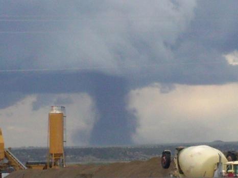
This was from Yesterday at a jobsite East Of Fishers Peak In Trinidad Colorado.
the front range has had Tore-nadies everyday this past week and more are likely today. Or so the weathermen are telling us.
FYI the term, Front range means the eastern slopes of the Rocky Mountains, or everything east of Denver, kind of.
Tornado Watch Missouri to Illinois 6/7/2014
Valid For: Northeast MO … West to West Central IL …
Forecast Office: Public Weather Service.com has issued a Tornado Watch effective now through this evening …
Issued: 6/7/14 at 12:00pm CDT

Valid For: Northeast MO … West to West Central IL …
Forecast Office: Public Weather Service.com has issued a Tornado Watch effective now through this evening …
Issued: 6/7/14 at 12:00pm CDT
If you are near DIMMIT TX, seek TORNADO SHELTER NOW! Rain wrapped hook echo on radar! Possible tornado
Storms to Rattle Texas to Missouri, Tennessee Thursday
Cities in the path of locally severe thunderstorms into Thursday evening include Dallas and San Antonio, Texas; Shreveport and Monroe, Louisiana; Little Rock and Texarkana, Arkansas; Poplar Bluff, Missouri; Greenville, Mississippi; and Memphis, Tennessee.
Stephenville, TX area - Tornado watch until midnight
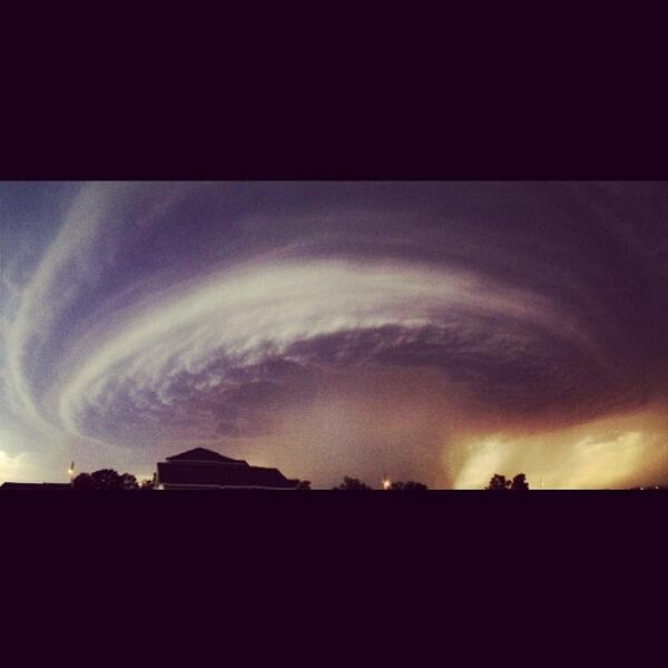
Double Tornado in Pilger,
NebraskaOmah
a.com
Link above has plenty of pictures and a link to live storm chasers
from NOAA
Brian Davidson, a freelance photojournalist and storm chaser in Pilger, Nebraska, around 5 p.m., said the northern part of Pilger had been hit by one or two tornadoes.
Every structure he could see for five or six blocks had been damaged. Some injuries may have occurred. Pilger, in Stanton County, has a population of 378.
Stanton County emergency officials could not be reached by telephone.
"There's no street signs left," Davidson said. "Cars are tossed."
He also saw a car inside a home. "It's very chaotic here right now."
Link above has plenty of pictures and a link to live storm chasers
from NOAA
TORNADO WARNING
IAC149-193-NEC043-SDC127-162330-
/O.NEW.KFSD.TO.W.0025.140616T2247Z-140616T2330Z/
BULLETIN - EAS ACTIVATION REQUESTED
TORNADO WARNING
NATIONAL WEATHER SERVICE SIOUX FALLS SD
547 PM CDT MON JUN 16 2014
THE NATIONAL WEATHER SERVICE IN SIOUX FALLS HAS ISSUED A
* TORNADO WARNING FOR...
SOUTHWESTERN PLYMOUTH COUNTY IN NORTHWEST IOWA...
NORTHWESTERN WOODBURY COUNTY IN WEST CENTRAL IOWA...
NORTHEASTERN DAKOTA COUNTY IN NORTHEAST NEBRASKA...
SOUTHEASTERN UNION COUNTY IN SOUTHEAST SOUTH DAKOTA...
* UNTIL 630 PM CDT
* AT 543 PM CDT...A CONFIRMED TORNADO WAS LOCATED NEAR JACKSON...AND
MOVING NORTHEAST AT 30 MPH.
HAZARD...DAMAGING TORNADO AND PING PONG BALL SIZE HAIL.
SOURCE...WEATHER SPOTTERS CONFIRMED TORNADO.
IMPACT...FLYING DEBRIS WILL BE DANGEROUS TO THOSE CAUGHT WITHOUT
SHELTER. MOBILE HOMES WILL BE DAMAGED OR DESTROYED. DAMAGE
TO ROOFS...WINDOWS AND VEHICLES WILL OCCUR. TREE DAMAGE IS
LIKELY.
* THE TORNADO WILL BE NEAR...
SOUTH SIOUX CITY AROUND 555 PM CDT.
NORTH SIOUX CITY AND STONE STATE PARK AROUND 600 PM CDT.
JEFFERSON AROUND 605 PM CDT.
PRECAUTIONARY/PREPAREDNESS ACTIONS...
THIS STORM HAS A HISTORY OF PRODUCING TORNADOES. TAKE COVER IN A
BASEMENT OR STORM SHELTER NOW!
&&
LAT...LON 4279 9649 4271 9625 4243 9643 4249 9663
TIME...MOT...LOC 2247Z 205DEG 28KT 4245 9656
TORNADO...OBSERVED
HAIL...1.50IN
Severe weather unfolding across portions of the northern Plains have spawned multiple tornadoes across Nebraska, causing damage to at least one structure. The Lincoln Journal Star is reporting catastrophic damage to the town of Pilger, Nebraska according to reports from the scene.
The severe weather threat is expected to encompass areas from Omaha, Nebraska to Minneapolis, Minnesota. Minneapolis, along with Des Moines, Iowa and Madison Wisconsin is expected to be impacted later Monday evening.

link
new topics
-
VP's Secret Service agent brawls with other agents at Andrews
Mainstream News: 23 minutes ago -
Sunak spinning the sickness figures
Other Current Events: 1 hours ago -
Nearly 70% Of Americans Want Talks To End War In Ukraine
Political Issues: 1 hours ago -
Late Night with the Devil - a really good unusual modern horror film.
Movies: 3 hours ago -
Cats Used as Live Bait to Train Ferocious Pitbulls in Illegal NYC Dogfighting
Social Issues and Civil Unrest: 4 hours ago -
The Good News According to Jesus - Episode 1
Religion, Faith, And Theology: 6 hours ago -
HORRIBLE !! Russian Soldier Drinking Own Urine To Survive In Battle
World War Three: 8 hours ago -
Bobiverse
Fantasy & Science Fiction: 11 hours ago -
Florida man's trip overseas ends in shock over $143,000 T-Mobile phone bill
Social Issues and Civil Unrest: 11 hours ago
top topics
-
Florida man's trip overseas ends in shock over $143,000 T-Mobile phone bill
Social Issues and Civil Unrest: 11 hours ago, 8 flags -
SETI chief says US has no evidence for alien technology. 'And we never have'
Aliens and UFOs: 15 hours ago, 7 flags -
Cats Used as Live Bait to Train Ferocious Pitbulls in Illegal NYC Dogfighting
Social Issues and Civil Unrest: 4 hours ago, 7 flags -
This is our Story
General Entertainment: 17 hours ago, 4 flags -
Former Labour minister Frank Field dies aged 81
People: 13 hours ago, 4 flags -
Bobiverse
Fantasy & Science Fiction: 11 hours ago, 3 flags -
HORRIBLE !! Russian Soldier Drinking Own Urine To Survive In Battle
World War Three: 8 hours ago, 2 flags -
Nearly 70% Of Americans Want Talks To End War In Ukraine
Political Issues: 1 hours ago, 2 flags -
Late Night with the Devil - a really good unusual modern horror film.
Movies: 3 hours ago, 2 flags -
VP's Secret Service agent brawls with other agents at Andrews
Mainstream News: 23 minutes ago, 1 flags
active topics
-
VP's Secret Service agent brawls with other agents at Andrews
Mainstream News • 9 • : watchitburn -
Breaking Baltimore, ship brings down bridge, mass casualties
Other Current Events • 483 • : KrustyKrab -
SETI chief says US has no evidence for alien technology. 'And we never have'
Aliens and UFOs • 37 • : SchrodingersRat -
President BIDEN Vows to Make Americans Pay More Federal Taxes in 2025 - Political Suicide.
2024 Elections • 120 • : ImagoDei -
Truth Social goes public, be careful not to lose your money
Mainstream News • 126 • : Zanti Misfit -
Nearly 70% Of Americans Want Talks To End War In Ukraine
Political Issues • 6 • : budzprime69 -
HORRIBLE !! Russian Soldier Drinking Own Urine To Survive In Battle
World War Three • 25 • : Freeborn -
Definitive 9.11 Pentagon EVIDENCE.
9/11 Conspiracies • 422 • : Zanti Misfit -
How ageing is" immune deficiency"
Medical Issues & Conspiracies • 30 • : annonentity -
Remember These Attacks When President Trump 2.0 Retribution-Justice Commences.
2024 Elections • 55 • : Zanti Misfit