It looks like you're using an Ad Blocker.
Please white-list or disable AboveTopSecret.com in your ad-blocking tool.
Thank you.
Some features of ATS will be disabled while you continue to use an ad-blocker.

MH370 missing (Part 2)
page: 19share:
originally posted by: Arbitrageur
Sorry that's not logical it's impossible. It would have to fly underwater to fly in a straight line instead of the great circle. The great circle is the closest to a straight line path it can fly at a constant altitude (meaning without flying underground or underwater like it would have to do in a straight line).
originally posted by: earthling42
it would be logical that it traveled in a strait line, not a great circle.
I think what Earthling is trying to say is they flew a Rhumb line which is simply to fly a heading on autopilot rather than a great circle route which curves.
So the report says it went off radar at way point BITOD, which is east of IGARI after a turn.
Weren't the officials always stating it turned west at IGARI or what that just the way they drew the graphics and felt the eastward part was 'meaningless'.
Weren't the officials always stating it turned west at IGARI or what that just the way they drew the graphics and felt the eastward part was 'meaningless'.
originally posted by: roadgravel
So the report says it went off radar at way point BITOD, which is east of IGARI after a turn.
Weren't the officials always stating it turned west at IGARI or what that just the way they drew the graphics and felt the eastward part was 'meaningless'.
As I have always maintained MH370 turned east 040 degrees at IGARI towards BITOD, but if you keep following BITOD past that waypoint is Con Son Island roughly where the oil rig worker spotted an aircraft on fire for 10-15 seconds.
a reply to: sy.gunson
I thought one of the last data points from FR24 showed the turn. Flying farther east would make the rig sighting even more realistic.
I have to wonder if the plane on Malaysian radar was MH370 unless they turned later and headed back. Guess checking the times would tell if that was possible.
I thought one of the last data points from FR24 showed the turn. Flying farther east would make the rig sighting even more realistic.
I have to wonder if the plane on Malaysian radar was MH370 unless they turned later and headed back. Guess checking the times would tell if that was possible.
originally posted by: roadgravel
a reply to: sy.gunson
I thought one of the last data points from FR24 showed the turn. Flying farther east would make the rig sighting even more realistic.
I have to wonder if the plane on Malaysian radar was MH370 unless they turned later and headed back. Guess checking the times would tell if that was possible.
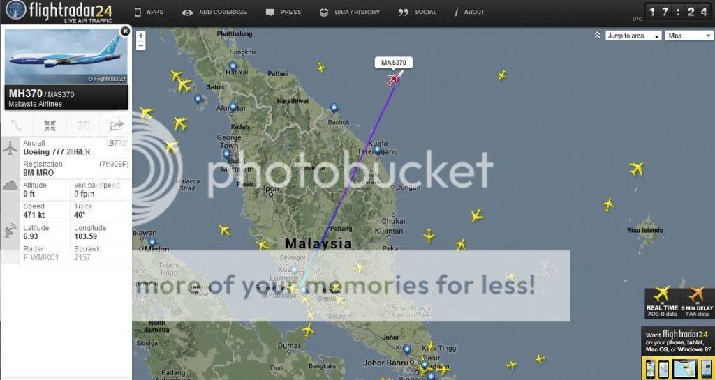
I previously took this screen shot.
17:24 UTC
There was a reported explosion detected on the seabed along the same flightpath 85 minutes into the flight. It was detected on the seabed by seismic sensors but was not an earthquake.
I have measured the distance to Penang from the location at 17:24 UTC which is 250nm and flying back at 35,000ft would take 32 minutes. Malaysia claims it covered the distance in "nearly 20 minutes" ata conference in Beijing on 29 April.
edit on 1-5-2014 by sy.gunson because: (no reason given)
This in report
Nothing about the time the info was received if true. Signal download? This has to have been determined as wrong.
edit:
I see now it was a projection, not real data.
2:35:03
MAS OPS Centre informed KL-ATCC MH370 in normal condition based
on signal download giving coordinate N14.90000 E109 15 00 at time
2:35:54
KL-ATCC relayed to HCM the latitude and longitude as advised by
Malaysian Airlines Operations.
Nothing about the time the info was received if true. Signal download? This has to have been determined as wrong.
edit:
I see now it was a projection, not real data.
edit on 5/1/2014 by roadgravel because: (no reason given)
originally posted by: roadgravel
This in report
2:35:03
MAS OPS Centre informed KL-ATCC MH370 in normal condition based
on signal download giving coordinate N14.90000 E109 15 00 at time
2:35:54
KL-ATCC relayed to HCM the latitude and longitude as advised by
Malaysian Airlines Operations.
Nothing about the time the info was received if true. Signal download? This has to have been determined as wrong.
edit:
I see now it was a projection, not real data.
The signal up to 17:27 UTC appears to be from the transponder. There was no feed after 17:27 UTC.
I was referring to the report. The people involved seem to have been misinterpreting what they were being told.
The projected position was given but was thought to be was actual data received. It was conflicting due the previous data outage but now it was said to be an error.
The projected position was given but was thought to be was actual data received. It was conflicting due the previous data outage but now it was said to be an error.
Did Malaysia provide exact coordinates for the start and end of what they said took nearly 20 minutes? If not how do you know there's not some discrepancy in what they're saying versus what you're calculating that would explain the 12 minutes difference?
originally posted by: sy.gunson
There was a reported explosion detected on the seabed along the same flightpath 85 minutes into the flight. It was detected on the seabed by seismic sensors but was not an earthquake.
I have measured the distance to Penang from the location at 17:24 UTC which is 250nm and flying back at 35,000ft would take 32 minutes. Malaysia claims it covered the distance in "nearly 20 minutes" ata conference in Beijing on 29 April.
[speculation] I think anything told to the relatives in the hotels is going to be highly suspect. It is probably based on truth, but 'bent' a
little.
When you have a group of very emotional people together, they probably tend to work each other up and in a situation like a briefing it is bound to get heated. I feel that the authorities were 'economic' with the truth and probably said what was expected or convenient. If this "about 20 minutes" thing was said at a briefing, I think it might have been changed somewhat. I can imagine someone saying "Well, 40 minutes is 'nearly 20 minutes' isn't it?" and then they go with the 20-minutes thing. On the other hand of course, it could be a misunderstanding or a mis-communication along the line. [/speculation]
Previous accident preliminary reports have been far, far longer (like 50-100+ pages) and I have seen it reported that this one is the minimum the Malaysians could get away with.
The New Straits Times is a pretty good resource and if you enter
site:nst.com.my inurl:font-color-red-mh370-tragedy-font
into Google you get all the MH370 articles
edit on 2 May 2014 by qmantoo because: add NST search
originally posted by: Arbitrageur
Did Malaysia provide exact coordinates for the start and end of what they said took nearly 20 minutes? If not how do you know there's not some discrepancy in what they're saying versus what you're calculating that would explain the 12 minutes difference?
originally posted by: sy.gunson
There was a reported explosion detected on the seabed along the same flightpath 85 minutes into the flight. It was detected on the seabed by seismic sensors but was not an earthquake.
I have measured the distance to Penang from the location at 17:24 UTC which is 250nm and flying back at 35,000ft would take 32 minutes. Malaysia claims it covered the distance in "nearly 20 minutes" ata conference in Beijing on 29 April.
No they did not but Malaysia has been resisting disclosure of an exact timeline for weeks and suddenly let slip a scrap of information which does identify the timeline.
Nobody put words in their mouth. Malaysian Authorities released the claim to relatives. In the absence of Malaysai taking steps to clarify further we are entitled to take a natural inference from it.
The last voice contact has always been identified as 17:19 UTC.
Flightradar24 website provides a direct feed from ADS-B / ADS-C devices transmitting through transponders and these give us location references independent of the Malaysian report.
originally posted by: qmantoo
[speculation] I think anything told to the relatives in the hotels is going to be highly suspect. It is probably based on truth, but 'bent' a little.
When you have a group of very emotional people together, they probably tend to work each other up and in a situation like a briefing it is bound to get heated. I feel that the authorities were 'economic' with the truth and probably said what was expected or convenient. If this "about 20 minutes" thing was said at a briefing, I think it might have been changed somewhat. I can imagine someone saying "Well, 40 minutes is 'nearly 20 minutes' isn't it?" and then they go with the 20-minutes thing. On the other hand of course, it could be a misunderstanding or a mis-communication along the line. [/speculation]
Previous accident preliminary reports have been far, far longer (like 50-100+ pages) and I have seen it reported that this one is the minimum the Malaysians could get away with.
The New Straits Times is a pretty good resource and if you enter
site:nst.com.my inurl:font-color-red-mh370-tragedy-font
into Google you get all the MH370 articles
New Straits Times is a propaganda rag for the ruling party and is controlled by that party.
That makes no sense saying nearly 20 minutes if you mean 40 minutes.
The only consistent fact about Malaysia's claims have been their refusal to release solid reliable information. The only time they have ever released dependable information has been at closed briefings for relatives.
Claims sourced from New Straits Times are usually a mixture of gossip, speculation and innuendo, credited to unnamed sources close to the investigation.
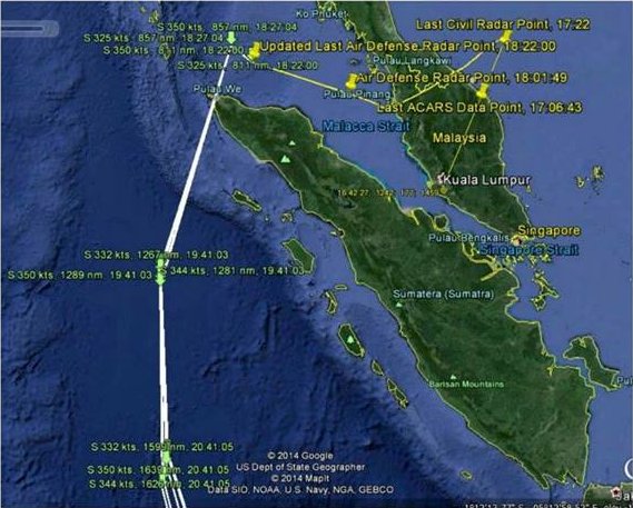
We know it was at waypoint BITOD, that is about 5 minutes after IGARI.
At 17:21 it passes by IGARI and flies towards BITOD heading 040, so i would say 17:27 is indeed the time that the aircraft vanished from radar.
The calculated (ground) speed is 475 knots.
From BITOD to the west coast takes the aircraft 33 minutes and it has had to make a U turn as soon as it had passed by BITOD.
So it would probably have reached the westcoast at 02:08 if it flew directly to Penang, but it is also stated that it was in Cambodian airspace.
If the aircraft did not flew directly to Penang, it could not have been on the westcoast at 02:08.
The fact that it was at BITOD eliminates the the claim that it had deviated from it's flight path at waypoint IGARI.
It seems highly unlikely to me that it deviated from it's flight path as soon as it had vanished from the Vietnamese radar at waypoint BITOD, so i am sceptical that it was at the westcoast at 02:08.
Within 20 minutes is totally impossible, it would have had to fly with a speed of 750 knots to accomplish that.
But let's say that it was at the westcoast at 02:08,... no let's skip the rest, i just had another look at this map.

Above the Malacca strait at 18:01 whehehe...


At 17:21 it passes by IGARI and flies towards BITOD heading 040, so i would say 17:27 is indeed the time that the aircraft vanished from radar.
The calculated (ground) speed is 475 knots.
From BITOD to the west coast takes the aircraft 33 minutes and it has had to make a U turn as soon as it had passed by BITOD.
So it would probably have reached the westcoast at 02:08 if it flew directly to Penang, but it is also stated that it was in Cambodian airspace.
If the aircraft did not flew directly to Penang, it could not have been on the westcoast at 02:08.
The fact that it was at BITOD eliminates the the claim that it had deviated from it's flight path at waypoint IGARI.
It seems highly unlikely to me that it deviated from it's flight path as soon as it had vanished from the Vietnamese radar at waypoint BITOD, so i am sceptical that it was at the westcoast at 02:08.
Within 20 minutes is totally impossible, it would have had to fly with a speed of 750 knots to accomplish that.
But let's say that it was at the westcoast at 02:08,... no let's skip the rest, i just had another look at this map.
Above the Malacca strait at 18:01 whehehe...
The natural inference I make from an offhand remark unsupported by any documentation is that it was an offhand remark. They did release a pictorial timeline in the latest batch of docs, so if the 20 minutes conflicts with that then the 20 minutes is most likely in error, but it seems to assume that MH370 was the UFO and they've admitted that they're not 100% certain it was.
originally posted by: sy.gunson
No they did not but Malaysia has been resisting disclosure of an exact timeline for weeks and suddenly let slip a scrap of information which does identify the timeline.
Nobody put words in their mouth. Malaysian Authorities released the claim to relatives. In the absence of Malaysai taking steps to clarify further we are entitled to take a natural inference from it.
www.facebook.com...#!/HishammuddinH2O/
That's the timeline you should be analyzing to see if it's credible (if you want to analyze a timeline), not the 20 minute remark.
edit on
2-5-2014 by Arbitrageur because: clarification
Apparently there should be a few more documents which provide detail to the cargo manifest. These we have not seen yet. They would show whether there
is any strange or unusual cargo 'hiding' in the consolidated pallets which do not have details in our copy of the report.
Also, Bangladesh is supposed to have sent a couple of ships to check out the Georesonance reported submerged debris.
Also, Bangladesh is supposed to have sent a couple of ships to check out the Georesonance reported submerged debris.
a reply to: Arbitrageur
No i don't think we should analize that, we know that it flew to BITOD as planned but in this (obviously early dated image) it shows a deviation from the original flight plan at, or just before reaching waypoint IGARI.
If they wanted credibility, they should and could have posted the original radarplots which clearly shows the flight path of the aircraft.
The fact that this is not done and another plot only shows a supposed track of MH370 without the other traffic nearby indicates to me that they are merely producing images to fit their claims, and of course it matches because it is calculated.
Conclusion, they did not track MH370 with a military radar.
Not much attention was given to the notion that the people in Kudahuvadhoo Maldives had spotted a low flying jet.
According to some it was 09:15 Malaysian time when they supposedly had spotted the low flying jet.
Because of this time stamp it was discarded as "not possible" because at that time the aircraft had 'possibly crashed' already.
After 08:19 there has been no handshake or any signal which does not mean it is the time of the crash, only that it happened between 08:19 and 09:19.
The time difference between the Maldives and Malaysia is two hours, so it is possible that they had indeed spotted MH370 at 06:15 or 08:15 Malaysian time.
The first airliner to fly past the Maldives and 160 miles east from Kudahuvadhoo was at 08:00 or 10:00 Malaysian time.
This brings me back to the fire bottle which was found on a beach in Baraah Maldives, but we have not heard from this object anymore because no further information was received about it.
a reply to: earthling42
The 0819 ping was a partial handshake. That was almost certainly when the aircraft lost power, and the aircraft tried to report it, but was unable to. The next expected ping was at 0911, which would have put them over the Maldives 4 minutes after the ping should have occurred.
The 0819 ping was a partial handshake. That was almost certainly when the aircraft lost power, and the aircraft tried to report it, but was unable to. The next expected ping was at 0911, which would have put them over the Maldives 4 minutes after the ping should have occurred.
new topics
-
God's Righteousness is Greater than Our Wrath
Religion, Faith, And Theology: 11 minutes ago -
Electrical tricks for saving money
Education and Media: 3 hours ago -
VP's Secret Service agent brawls with other agents at Andrews
Mainstream News: 4 hours ago -
Sunak spinning the sickness figures
Other Current Events: 5 hours ago -
Nearly 70% Of Americans Want Talks To End War In Ukraine
Political Issues: 5 hours ago -
Late Night with the Devil - a really good unusual modern horror film.
Movies: 7 hours ago -
Cats Used as Live Bait to Train Ferocious Pitbulls in Illegal NYC Dogfighting
Social Issues and Civil Unrest: 8 hours ago -
The Good News According to Jesus - Episode 1
Religion, Faith, And Theology: 10 hours ago
top topics
-
Florida man's trip overseas ends in shock over $143,000 T-Mobile phone bill
Social Issues and Civil Unrest: 15 hours ago, 8 flags -
Cats Used as Live Bait to Train Ferocious Pitbulls in Illegal NYC Dogfighting
Social Issues and Civil Unrest: 8 hours ago, 8 flags -
VP's Secret Service agent brawls with other agents at Andrews
Mainstream News: 4 hours ago, 8 flags -
Former Labour minister Frank Field dies aged 81
People: 17 hours ago, 4 flags -
Bobiverse
Fantasy & Science Fiction: 15 hours ago, 3 flags -
HORRIBLE !! Russian Soldier Drinking Own Urine To Survive In Battle
World War Three: 12 hours ago, 3 flags -
Electrical tricks for saving money
Education and Media: 3 hours ago, 3 flags -
Nearly 70% Of Americans Want Talks To End War In Ukraine
Political Issues: 5 hours ago, 3 flags -
Sunak spinning the sickness figures
Other Current Events: 5 hours ago, 3 flags -
Late Night with the Devil - a really good unusual modern horror film.
Movies: 7 hours ago, 2 flags
active topics
-
VP's Secret Service agent brawls with other agents at Andrews
Mainstream News • 32 • : ThatSmellsStrange -
The Reality of the Laser
Military Projects • 46 • : Zaphod58 -
God's Righteousness is Greater than Our Wrath
Religion, Faith, And Theology • 0 • : randomuser2034 -
President BIDEN Vows to Make Americans Pay More Federal Taxes in 2025 - Political Suicide.
2024 Elections • 136 • : ImagoDei -
Electrical tricks for saving money
Education and Media • 3 • : Mike72 -
TLDR post about ATS and why I love it and hope we all stay together somewhere
General Chit Chat • 10 • : theshadowknows -
Why to avoid TikTok
Education and Media • 20 • : 5thHead -
How ageing is" immune deficiency"
Medical Issues & Conspiracies • 32 • : annonentity -
-@TH3WH17ERABB17- -Q- ---TIME TO SHOW THE WORLD--- -Part- --44--
Dissecting Disinformation • 657 • : daskakik -
HORRIBLE !! Russian Soldier Drinking Own Urine To Survive In Battle
World War Three • 30 • : DaRAGE