It looks like you're using an Ad Blocker.
Please white-list or disable AboveTopSecret.com in your ad-blocking tool.
Thank you.
Some features of ATS will be disabled while you continue to use an ad-blocker.

Queensland Australia Is About to Get Slammed With Cat 5 Cyclone Ita- Possibly Worst in Their History
page: 12
share:
www.bom.gov.au...
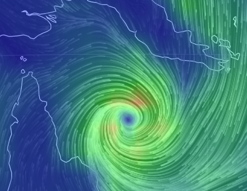
SEVERE TROPICAL CYCLONE ITA, CATEGORY 5, poses a significant threat to communities along the far north Queensland coast. At this stage it is expected to move to the southwest and make landfall between Cape Melville and Cape Tribulation later on Friday as a SEVERE CATEGORY 5 TROPICAL CYCLONE with VERY DESTRUCTIVE WINDS near the core and GALES extending some distance from the landfall location.
DESTRUCTIVE WINDS may develop between Cape Melville and Cooktown from as early as sunrise Friday morning before extending inland to Laura and further south to Cape Tribulation and possibly Port Douglas later in the day.
GALES may develop between Lockhart RIver and Cape Tribulation during Friday morning before extending further south to Innisfail and inland to Kalinga, Palmerville, and Laura, and Chillagoe later in the day as the system moves closer to the coast and over land.
Coastal residents between Cape Melville and Cape Tribulation including Cooktown are specifically warned of the dangerous storm tide as the cyclone crosses the coast later on Friday. The sea is likely to rise steadily up to a level which will be significantly above the normal tide, with damaging waves, strong currents and flooding of low-lying areas extending some way inland. People living in areas likely to be affected by this flooding should take measures to protect their property as much as possible and be prepared to follow instructions regarding evacuation of the area if advised to do so by the authorities. Coastal residents between Innisfail and Port Douglas, including Cairns should monitor the situation in case the cyclone takes a more southerly track than expected.
This looks pretty darn bad. Worse than that, actually. Reading reports of winds over 200 km/hr expected. People have cleared grocery shelves and many are already evacuating.
Visit link above for map projection.
edit on Thu Apr 10th 2014 by TrueAmerican because: (no reason given)
Sorry TA, someone beat you to it :
www.abovetopsecret.com...
Kindest respects
Rodinus
www.abovetopsecret.com...
Kindest respects
Rodinus
edit on 10/4/14 by Rodinus because: Crap spelling
reply to post by TrueAmerican
Third Super Storm in two years with Sandy and Haiyan leading the way to the "New Normal"
Get used to it, world!
Third Super Storm in two years with Sandy and Haiyan leading the way to the "New Normal"
Get used to it, world!
Thank goodness! At least its not a hurricane, typhoon, monsoon or a tsunami!
new topics
-
God's Righteousness is Greater than Our Wrath
Religion, Faith, And Theology: 1 hours ago -
Electrical tricks for saving money
Education and Media: 4 hours ago -
VP's Secret Service agent brawls with other agents at Andrews
Mainstream News: 5 hours ago -
Sunak spinning the sickness figures
Other Current Events: 6 hours ago -
Nearly 70% Of Americans Want Talks To End War In Ukraine
Political Issues: 6 hours ago -
Late Night with the Devil - a really good unusual modern horror film.
Movies: 8 hours ago -
Cats Used as Live Bait to Train Ferocious Pitbulls in Illegal NYC Dogfighting
Social Issues and Civil Unrest: 9 hours ago -
The Good News According to Jesus - Episode 1
Religion, Faith, And Theology: 11 hours ago
top topics
-
Florida man's trip overseas ends in shock over $143,000 T-Mobile phone bill
Social Issues and Civil Unrest: 16 hours ago, 8 flags -
Cats Used as Live Bait to Train Ferocious Pitbulls in Illegal NYC Dogfighting
Social Issues and Civil Unrest: 9 hours ago, 8 flags -
VP's Secret Service agent brawls with other agents at Andrews
Mainstream News: 5 hours ago, 8 flags -
Bobiverse
Fantasy & Science Fiction: 16 hours ago, 3 flags -
HORRIBLE !! Russian Soldier Drinking Own Urine To Survive In Battle
World War Three: 13 hours ago, 3 flags -
Electrical tricks for saving money
Education and Media: 4 hours ago, 3 flags -
Nearly 70% Of Americans Want Talks To End War In Ukraine
Political Issues: 6 hours ago, 3 flags -
Sunak spinning the sickness figures
Other Current Events: 6 hours ago, 3 flags -
Late Night with the Devil - a really good unusual modern horror film.
Movies: 8 hours ago, 2 flags -
The Good News According to Jesus - Episode 1
Religion, Faith, And Theology: 11 hours ago, 1 flags
2