It looks like you're using an Ad Blocker.
Please white-list or disable AboveTopSecret.com in your ad-blocking tool.
Thank you.
Some features of ATS will be disabled while you continue to use an ad-blocker.

4.8 earthquake rocks US Yellowstone National Park
page: 1share:
The birds are singing, the grass is green and Yellowstone is gonna kill us all.
Another fine day in America
I'm starting to feel as if Mother Earth has finally had enough of our s***.
Well, back to the weather bunker! *tin foil hat mode = ON*
Source
Another fine day in America
A 4.8 magnitude quake rocked Yellowstone National Park in Wyoming near the border with Montana, the US Geological Survey said. There were several aftershocks with a magnitude over 3.
The earthquake occurred 37 kilometers northeast of West Yellowstone, Montana at 6:34 am local time (1234 GMT) Sunday.
The quake was centered almost in the middle of Yellowstone National Park, near the Norris Geyser Basin, said Peter Cervelli, a spokesman for the USGS Yellowstone Volcano Observatory, NBC News reported.
He added that any damage from the temblor would likely be minor, noting there are not many visitors in the park at the moment.
There were no immediate reports of damage.
According to USGS there were four aftershocks recorded with a magnitude from 3.1 to 3.3. The USGS said that more are expected.
The secondary shockwaves are usually less violent than the main quake but can be strong enough to do additional damage to weakened structures, the USGS said.
I'm starting to feel as if Mother Earth has finally had enough of our s***.
Well, back to the weather bunker! *tin foil hat mode = ON*
Source
edit on 3-30-2014 by AnarchistoOfTheNorth because: (no reason
given)
Makes you wonder what would really happen with all the predictions about Yellowstone. Not sure how often that it has earthquakes but I'll definitely
keep an ear open for more news.
This is normal, It's a very seismically active area, stop fear mongering, this isn't a sign of catastrophe.
reply to post by AnarchistoOfTheNorth
Here's the seismograph chart , can't say it means anything to me but some may be interested and understand it.
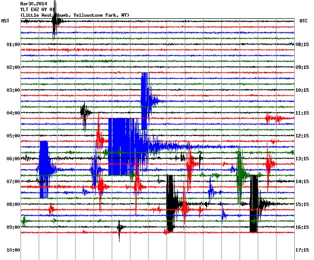
If you look at the last few days on the site linked bellow it puts the large squiggles into context , 4.8 is quite large.
quake.utah.edu...
Here's the seismograph chart , can't say it means anything to me but some may be interested and understand it.
If you look at the last few days on the site linked bellow it puts the large squiggles into context , 4.8 is quite large.
quake.utah.edu...
edit on 30-3-2014 by gortex because: (no reason given)
Here is a webcam link to Old Faithful.
The camera was shaking a few minutes ago. Unsure if it was wind or EQ.
Old Faithful Live Cam
It is kind of snowy and crappy weather,
but I was watching a few different cams and this one was shaking,
not sure why as it stopped.
and now shaking again...
Wind?
*ponder*
The camera was shaking a few minutes ago. Unsure if it was wind or EQ.
Old Faithful Live Cam
It is kind of snowy and crappy weather,
but I was watching a few different cams and this one was shaking,
not sure why as it stopped.
and now shaking again...
Wind?
*ponder*
edit on 30-3-2014 by Darkblade71 because: (no reason given)
Personally, I sure open a link about a 4.8 in Yellowstone. That's getting up there on the scale for noticing, IMO.
It wouldn't be more than trivial interest if it weren't for the sudden increase in California activity at the same time. That moves it to at least 'something to follow' on my priority pyramid.
It wouldn't be more than trivial interest if it weren't for the sudden increase in California activity at the same time. That moves it to at least 'something to follow' on my priority pyramid.
edit on 30-3-2014 by Wrabbit2000 because: (no reason given)
reply to post by Darkblade71
Thanks for the web cam live link, Darkblade. It may be the one to keep an eye on today, with the way things are shaking up.
Des
Thanks for the web cam live link, Darkblade. It may be the one to keep an eye on today, with the way things are shaking up.
Des
@Darkblade the webcam you provided keeps on shaking lol. What's that all about?
reply to post by MessageforAll
I'm not sure.
I watched it for about an hour and it was still and then it started to shake.
At one point it looks like someone zoomed in on the geyser and back out.
But yeah, it is still shaking now.
It's been like that for a while though,(half an hour)
which probably means it's not an EQ....
but who knows???
reply to post by MessageforAll
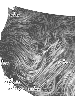
I just saw this and at the moment, it's an interesting wind pattern which is near Yellowstone. Nothing radical to be a story itself, but they form kinda strange sometimes and that map is basically real time wind from what I understand by using it awhile. Not sure if that would impact the view, but someone mentioned wind earlier?
Real Time National Wind Map
** I figured I'd screen cap it this time for the record.
edit on 30-3-2014 by Wrabbit2000 because: Added screen shot
Maybe it's a prelude to god splitting the US in half with an EQ that the preachy types are beaking about of late. As long as god makes it stop at the
border I'm OK with it. It's not my countries fight....Between god and the US it is! Not sure about the shaking camera, looks like the autofocus may
be messed up.
Wrabbit2000
reply to post by MessageforAll
I just saw this and at the moment, it's an interesting wind pattern which is near Yellowstone. Nothing radical to be a story itself, but they form kinda strange sometimes and that map is basically real time wind from what I understand by using it awhile. Not sure if that would impact the view, but someone mentioned wind earlier?
Real Time National Wind Map
** I figured I'd screen cap it this time for the record.
edit on 30-3-2014 by Wrabbit2000 because: Added screen shot
Nice find. Looks almost like there is a wind drain over Yellowstone. North, South, East, West....all winds converging in one area.
reply to post by TerrorAlertRed
As a truckdriver, I get up into the Montana/Wyoming region quite a bit. The winds this time of year are vicious, so much so that at times they won't let you on the road if you are hauling a load that weighs less than 20,000 pounds.
I've been across that area with a gross weight of 80,000 pounds and have still been tossed about like a toy.
reply to post by AnarchistoOfTheNorth
yes, it was a 4.8, but I don't think this alone spells the apocalypse. She is certainly capable of creating one, but I'm afraid that if we come off as calling wolf too often, the ONE time it might mean something, most won't pay attention.
First, here is a link to the USGS site with a map and list of this possible swarm. I say possible, because it may just turn out to be a quake/aftershock series vs a true swarm or uplift event.
I am interested in the depths of these quakes, especially the largest. At that depth (around 6km) it could be coming from the chamber.
I will wait for TA to chime in before speculating further, but lets not panic anyone. Yellowstone is a live volcano with tons of activity on a regular basis. There are faults that can create this size of quake. Yes, a 4.8 quake will definitely get your heart pumping, but bigger have happened before without a serious outcome.
edit on 30-3-2014 by westcoast because: (no reason given)
Drezden
This is normal, It's a very seismically active area, stop fear mongering, this isn't a sign of catastrophe.
Yellowstone is not an area like Vanuatu or Chile, with massive earthquakes caused by huge plate tectonics. Those locations compared to Yellowstone are completely different geophysically. Yellowstone sits on a massive caldera (volcano) coupled with smaller faults.
A 4.8 is noteworthy because it isn't being caused solely by plate tectonics --- it's getting back up from a supervolcano.
> USGS
Today's event is the largest earthquake at Yellowstone since February 22, 1980, and occurred near the center of a region of recent ground uplift described in a YVO Information Statement on February 18, 2014. The Yellowstone Volcano Observatory has been tracking this uplift episode for about 7 months.
edit on 3/30/2014 by iamhobo because: (no
reason given)
Ok, so that's one, it's when it continues and we see other things along with it that we really start to worry. The following days or weeks will tell
us.
This is something to keep eye on. The largest quake since 1985 and that one was 4.9. What's interesting is that they say the caldera floor has
risen 3 inches each year between 2004-2008. They believe the crustal magna chamber is filling with molten rock. How long until it erupts?
So they are calling the 4.8 a main shock in this Press Release.
Press Release
University of Utah Seismograph Stations
Released: March 30, 2014 08:15 AM MDT
The University of Utah Seismograph Stations reports that a light earthquake occurred at 06:34 AM on March 30, 2014 (MDT). The epicenter of the magnitude 4.8 shock was located 4 miles north-northeast of Norris Geyser Basin in Yellowstone National Park, Wyoming. This earthquake is part of a series of earthquakes that began in this area on Thursday, March 27. As of 8:15 am today, this series has included at least 25 earthquakes in addition to the main shock, with the largest of magnitude 3.1. The magnitude 4.8 main shock was reported felt in Yellowstone National Park and in the towns of West Yellowstone and Gardiner, Montana.
Seismic information on the earthquake can be viewed at the University of Utah Seismograph Stations: www.seis.utah.edu...
Recent Quakes
MAG DATE LOCAL-TIME LAT LON DEPTH LOCATION
y/m/d h:m:s deg deg km
MAP 3.3 2014/03/30 09:12:24 44.777N 110.723W 6.0 29 km (18 mi) S of Gardiner, MT
MAP 3.1 2014/03/30 09:07:49 44.770N 110.720W 6.6 30 km (18 mi) S of Gardiner, MT
map 2.5 2014/03/30 07:56:40 44.770N 110.714W 7.7 30 km (18 mi) S of Gardiner, MT
MAP 3.1 2014/03/30 07:30:52 44.772N 110.698W 4.5 29 km (18 mi) S of Gardiner, MT
MAP 4.8 2014/03/30 06:34:39 44.778N 110.683W 6.8 29 km (18 mi) S of Gardiner, MT
MAP 3.0 2014/03/30 04:36:25 44.786N 110.690W 1.6 28 km (17 mi) S of Gardiner, MT
map 1.8 2014/03/30 01:10:59 36.891N 114.294W 4.0 20 km (12 mi) NW of Bunkerville, NV
map 2.8 2014/03/30 00:23:48 44.785N 110.681W 1.5 28 km (17 mi) S of Gardiner, MT
map 0.5 2014/03/28 09:41:43 44.825N 110.781W 3.1 24 km (15 mi) SSW of Gardiner, MT
map 2.0 2014/03/28 05:37:16 44.839N 110.513W 7.1 27 km (17 mi) SE of Gardiner, MT
map 2.5 2014/03/27 22:45:19 45.846N 111.796W 8.3 13 km ( 8 mi) W of Willow Creek, MT
map 1.9 2014/03/26 18:58:40 44.808N 110.773W 4.3 26 km (16 mi) S of Gardiner, MT
map 2.2 2014/03/26 18:20:59 44.800N 110.772W 4.1 27 km (17 mi) S of Gardiner, MT
map 1.5 2014/03/26 18:11:57 44.821N 110.774W 2.0 24 km (15 mi) S of Gardiner, MT
map 2.0 2014/03/26 18:00:10 44.799N 110.774W 3.9 27 km (17 mi) S of Gardiner, MT
MAP 3.5 2014/03/26 17:59:00 44.801N 110.778W 4.5 27 km (17 mi) S of Gardiner, MT
MAP 3.0 2014/03/26 13:14:36 44.804N 110.772W 6.4 26 km (16 mi) S of Gardiner, MT
map 0.5 2014/03/25 17:53:18 40.546N 111.296W 11.3 7 km ( 4 mi) SW of Woodland, UT
map 1.0 2014/03/25 17:53:11 40.565N 111.255W 12.8 3 km ( 2 mi) SW of Woodland, UT
map 1.6 2014/03/25 15:26:08 39.455N 111.209W 1.5 23 km (15 mi) ESE of Mount Pleasant, UT
map 1.8 2014/03/25 06:01:08 42.260N 111.340W 4.7 6 km ( 4 mi) NE of Paris, ID
map 1.3 2014/03/25 03:59:35 37.586N 112.332W 2.1 12 km ( 7 mi) SE of Hatch, UT
map 2.0 2014/03/24 15:39:42 36.986N 111.415W 7.9 9 km ( 6 mi) NNE of Page, AZ
map 1.4 2014/03/24 12:06:51 44.246N 110.444W 3.6 70 km (43 mi) SE of West Yellowstone, MT
map 1.7 2014/03/24 05:21:37 44.778N 110.774W 7.5 29 km (18 mi) S of Gardiner, MT
map 1.1 2014/03/23 22:55:22 44.574N 110.410W 2.7 56 km (35 mi) E of West Yellowstone, MT
map 1.4 2014/03/23 19:50:43 44.706N 111.905W 0.0 44 km (27 mi) NNE of Spencer, ID
map 1.6 2014/03/23 19:48:23 38.670N 112.154W 2.6 2 km ( 1 mi) SSW of Elsinore, UT
map 1.0 2014/03/23 19:02:24 37.395N 112.903W 3.1 25 km (16 mi) NNE of Springdale, UT
map 1.8 2014/03/23 17:53:23 38.817N 111.536W 13.9 27 km (17 mi) WSW of Emery, UT
Seismograph recordings from stations of the Yellowstone seismograph network can be viewed online at: quake.utah.edu...
Anyone who has felt recent earthquakes in Yellowstone is encouraged to fill out a form on the USGS Community Felt reports web site: earthquake.usgs.gov...
new topics
-
Should Biden Replace Harris With AOC On the 2024 Democrat Ticket?
2024 Elections: 28 minutes ago -
Intro once again
Introductions: 1 hours ago -
University student disciplined after saying veganism is wrong and gender fluidity is stupid
Education and Media: 3 hours ago -
Geddy Lee in Conversation with Alex Lifeson - My Effin’ Life
People: 4 hours ago -
God lived as a Devil Dog.
Short Stories: 4 hours ago -
Police clash with St George’s Day protesters at central London rally
Social Issues and Civil Unrest: 5 hours ago -
TLDR post about ATS and why I love it and hope we all stay together somewhere
General Chit Chat: 6 hours ago -
Hate makes for strange bedfellows
US Political Madness: 8 hours ago -
Who guards the guards
US Political Madness: 11 hours ago
top topics
-
Hate makes for strange bedfellows
US Political Madness: 8 hours ago, 16 flags -
Who guards the guards
US Political Madness: 11 hours ago, 13 flags -
Police clash with St George’s Day protesters at central London rally
Social Issues and Civil Unrest: 5 hours ago, 8 flags -
TLDR post about ATS and why I love it and hope we all stay together somewhere
General Chit Chat: 6 hours ago, 5 flags -
University student disciplined after saying veganism is wrong and gender fluidity is stupid
Education and Media: 3 hours ago, 5 flags -
Has Tesla manipulated data logs to cover up auto pilot crash?
Automotive Discussion: 13 hours ago, 2 flags -
Intro once again
Introductions: 1 hours ago, 2 flags -
Geddy Lee in Conversation with Alex Lifeson - My Effin’ Life
People: 4 hours ago, 2 flags -
God lived as a Devil Dog.
Short Stories: 4 hours ago, 2 flags -
Should Biden Replace Harris With AOC On the 2024 Democrat Ticket?
2024 Elections: 28 minutes ago, 1 flags
active topics
-
Should Biden Replace Harris With AOC On the 2024 Democrat Ticket?
2024 Elections • 4 • : watchitburn -
Lawsuit Seeks to ‘Ban the Jab’ in Florida
Diseases and Pandemics • 27 • : worldstarcountry -
Candidate TRUMP Now Has Crazy Judge JUAN MERCHAN After Him - The Stormy Daniels Hush-Money Case.
Political Conspiracies • 734 • : RazorV66 -
Terrifying Encounters With The Black Eyed Kids
Paranormal Studies • 65 • : daskakik -
"We're All Hamas" Heard at Columbia University Protests
Social Issues and Civil Unrest • 256 • : YourFaceAgain -
-@TH3WH17ERABB17- -Q- ---TIME TO SHOW THE WORLD--- -Part- --44--
Dissecting Disinformation • 630 • : RookQueen2 -
University student disciplined after saying veganism is wrong and gender fluidity is stupid
Education and Media • 15 • : TzarChasm -
Mood Music Part VI
Music • 3092 • : TheWoker -
Hate makes for strange bedfellows
US Political Madness • 35 • : Degradation33 -
Europe declares war on Russia?
World War Three • 67 • : 777Vader