It looks like you're using an Ad Blocker.
Please white-list or disable AboveTopSecret.com in your ad-blocking tool.
Thank you.
Some features of ATS will be disabled while you continue to use an ad-blocker.

Landslide In Washington Ongoing efforts to find survivors
page: 4share:
reply to post by westcoast
Westcoast, my thoughts and prayers are with you & yours. Ya'll be careful out there in your search and rescue work.
Westcoast, my thoughts and prayers are with you & yours. Ya'll be careful out there in your search and rescue work.
I'm out in the same area as WC and I am really surprised about this whole thing.
While it is a big news story now, it seems it was originally downplayed in regards to numbers of people affected. It began with very low numbers which led me to believe it was another event like last one.
I don't ever recall a list that lists the missing as reports? Now we've gone from a bit more than a dozen to nearly 200 missing?
They were asking for 60 volunteers for the morning, but they wanted them from Darrington and I'm in Bug (Sedro's original name - btw) down the road.
I'm really bothered by the fact that the first night there were cries for help heard that went unanswered because our public servants didn't want to risk any more lives, thus they wouldn't do anything except keep private SAR out. The fact is if nobody gets them out immediately they will die. It should be our own choice whether we risk our lives or not to save others.
The same thing happened to my brother where they quit searching for him in the dark because it was too dangerous. What a load of BS.
I'm out in the same area as WC and I am really surprised about this whole thing.
While it is a big news story now, it seems it was originally downplayed in regards to numbers of people affected. It began with very low numbers which led me to believe it was another event like last one.
I don't ever recall a list that lists the missing as reports? Now we've gone from a bit more than a dozen to nearly 200 missing reports?
They were asking for 60 volunteers for the morning, but they wanted them from Darrington and I'm in Bug (Sedro's original name - btw) down the road.
I'm really bothered by the fact that the first night there were cries for help heard that went unanswered because our public servants didn't want to risk any more lives, thus they wouldn't do anything except keep private SAR out. The fact is if nobody gets them out immediately they will die. It should be our own choice whether we risk our lives or not to save others.
The same thing happened to my brother where they quit searching for him in the dark because it was too dangerous. What a load of BS.
The area in question is just plain spooky. The road was like an expanding band aid, you had to drive slow because it through your car around. Not really sure why these type of areas get developed, but they do.
I'd been hiking the nearby hills two ridges north of the slide area and there have been dozens of junk trees falling the past two weeks. Junk meaning the not the planted species for logging harvest or the original cedar or other evergreen - lots of Birch type stuff just falling over exposing the roots.
edit on 3/25/14 by verylowfrequency because: (no reason given)
intrptr
reply to post by pryingopen3rdeye
looking at satellite photos of the area before the landslide occurred you can clearly see that exact spot has far less vegetation then the surrounding areas. which of course increases landslide risk significantly, im wondering why it has less vegetation, is it just naturally bare there? or was it perhaps all chopped down to be sold for timber?
We have a Bingo. The number one reason for these slides occurring in forested areas nowadays.
This activity also destroys river habitats down stream because even if there is no slide, the runoff from rains is not captured by the roots of trees and rivulets of mud run downslope into streams and rivers, choking them with silt and deoxygenating the water. Then you got problems with algae and fish dying, etc.
Logging (looks like clear cutting in this case) is the worst but most cost effective way to "harvest" a section of forest.
The depth if the cut in the mountainside is far to large and deep to be the result of lack of vegetation. This looks like deep saturation of unstable material not really first layer topsoil rolling off. This is more like a large chunk of a glacier falling off when conditions are right.
WestCoast, I may take you up on the offer of information for looking downstream. I have a job interview today in MV but will be back in touch when I
get back this afternoon. I've been following Skagit Breaking closely and they have the most info being released publicly but I'm guessing you may
know more contacts given your ties to the city, I don't know all the right people to get in touch with yet, I still consider myself a rookie cp
trying to learn everything I can quickly. I'll be back in touch later on. Thanks, you are doing a phenomenal job of keeping our ATS friends
informed of our local tragedy!!
reply to post by Logarock
It goes all the way up to the ridge line, doesn't it? It can't go any further because then gravity is pulling the reverse slope down the other way, towards the back side of the mountain. And yes, its deep (but not really). This is a low hill compared to the mountain ranges in the background. And its not made of rock. Mostly Moraine from those big mountains in the background is my guess. So its softer material that gets slippery when wet.
The "slide" did not start up at the top, but further down the hill due to ground saturation. There are no trees visible there so Its a good bet it began because the slope was not fixed by tree roots. Once it began lower down, the slope higher up had nothing to hold it up and it began a domino effect all the way up to the ridge line where it stopped. Kind of like pulling the bottom card out from under a house of cards, right? This all happens really fast. As soon as the bottom portion of the slope began slipping, the weight of the upper portion cut loose and pushed everything down into the valley.
This is unlike an avalanche where the a mass at the top gives way and rushes down the hill gathering momentum and riding the surface all the way down. This is why they call what happened a landslide (instead of an avalanche)
Also notice the mountain around the cut that didn't fail. Those trees prevented that because they absorb the rain and fix the soil with their roots so that can't happen. I don't really know why the trees are missing from the slide area, whether it was logging or something else like a "blowdown" in a storm or disease or what. But it is obvious that part of the hillside was denuded of tress and thats what eventually compromised the hillside due to over saturation by the rains.
This will come out of the investigation. They might cover it up though if some logging company is the culprit, however. This problem of destruction of forest ecosystems by logging is well known in the northwest. But hardly enters the main stream. That stream is clogged with the silt of lies, too.
The depth if the cut in the mountainside is far to large and deep to be the result of lack of vegetation. This looks like deep saturation of unstable material not really first layer topsoil rolling off. This is more like a large chunk of a glacier falling off when conditions are right.
It goes all the way up to the ridge line, doesn't it? It can't go any further because then gravity is pulling the reverse slope down the other way, towards the back side of the mountain. And yes, its deep (but not really). This is a low hill compared to the mountain ranges in the background. And its not made of rock. Mostly Moraine from those big mountains in the background is my guess. So its softer material that gets slippery when wet.
The "slide" did not start up at the top, but further down the hill due to ground saturation. There are no trees visible there so Its a good bet it began because the slope was not fixed by tree roots. Once it began lower down, the slope higher up had nothing to hold it up and it began a domino effect all the way up to the ridge line where it stopped. Kind of like pulling the bottom card out from under a house of cards, right? This all happens really fast. As soon as the bottom portion of the slope began slipping, the weight of the upper portion cut loose and pushed everything down into the valley.
This is unlike an avalanche where the a mass at the top gives way and rushes down the hill gathering momentum and riding the surface all the way down. This is why they call what happened a landslide (instead of an avalanche)
Also notice the mountain around the cut that didn't fail. Those trees prevented that because they absorb the rain and fix the soil with their roots so that can't happen. I don't really know why the trees are missing from the slide area, whether it was logging or something else like a "blowdown" in a storm or disease or what. But it is obvious that part of the hillside was denuded of tress and thats what eventually compromised the hillside due to over saturation by the rains.
This will come out of the investigation. They might cover it up though if some logging company is the culprit, however. This problem of destruction of forest ecosystems by logging is well known in the northwest. But hardly enters the main stream. That stream is clogged with the silt of lies, too.
How much of this is due to the movement of the fault lines? There have to be future projections which can lead to permanent evacuation areas so that
death tolls and late night horrors like this one do not continue in that area. What pisses me off is how all the funding and state of emergency $
goes towards political gains, contracts and secrecy payouts rather than the people affected and continued to be in dangers way.
Personally, I think that this whole thing is a dress rehearsal for even bigger events they know are coming. Keeping it all compartmentalized, localized did not work because of social networking. Even in a grid down people are learning how to pass information forward and bypassing the gag orders and media blackouts.
The sink holes were an indication, landslides, freak weather anomalies, tremors, it is all part of an ever moving and changing state of geological matter. You cannot blame it on forestation, or homes that were settled in generations ago because it is part of natures movement.
The Gov. pulls back more each time and laws are created to protect them from helping individuals or providing even the most basic of needs other than a temporary salvation Army shelter and a few hundred bucks for underwear and tooth brushes. At one point yes, FEMA was out in the field, they were helping people get back into their homes and lives, but now it is all about infrastructure and continuity of transportation and Gov.
One more thing, Helicopters and heavy tripods guy-lines could have been moved in immediately, they could have set up field lights like a stadium to
illuminate night to the brightest daylight.
(Cuss) baskets for injured, safety belts on the line to hang over the mud and ropes for people to grab onto.
This was handled horribly. The sounds of the trapped people were nothing short of evil when nothing was done to save them while they were still alive under the debris.
(Cuss) baskets for injured, safety belts on the line to hang over the mud and ropes for people to grab onto.
This was handled horribly. The sounds of the trapped people were nothing short of evil when nothing was done to save them while they were still alive under the debris.
edit on am331amTue, 25 Mar 2014 11:48:20 -0500 by antar because: (no reason given)
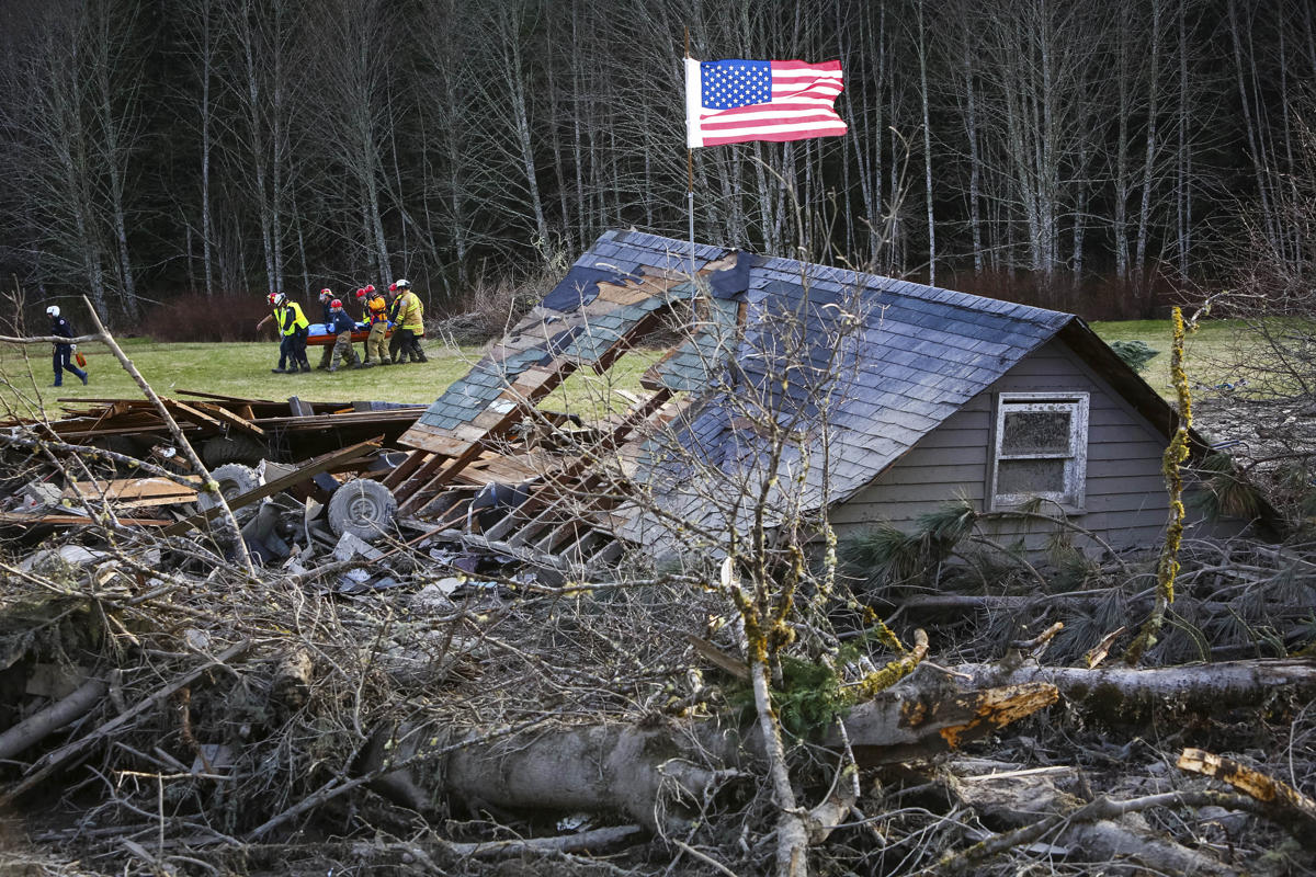
Deadly mudslide in Washington Rescue workers remove a body from the wreckage of homes destroyed by a mudslide near Oso, Wash, Monday, March 24, 2014. The search for survivors of Saturday's deadly mudslide grew Monday to include scores of people who were still unaccounted for as the death toll from the wall of trees, rocks and debris that swept through the rural community rose to at least 14. (AP Photo/seattlepi.com, Joshua Trujillo)
news.yahoo.com...

Some images...
www.google.com...:en-USfficial&client=firefox&channel=sb
Please dont let this be yesterdays news, keep giving the search engines the hits that we are watching.
www.google.com...:en-USfficial&client=firefox&channel=sb
Please dont let this be yesterdays news, keep giving the search engines the hits that we are watching.
reply to post by NiteNGale2
So sorry to hear of your personal issues and hope you are coping as best that you can. This is horrible and I too am wondering why it is not receiving more coverage.
What is wrong with these land developers building on places that are known to have previous or future problems. Why do they build in places that can collapse at a moments notice. These people built or bought homes and were probably unaware of any danger that the location of their home and families were in. This happens everywhere whether your home is on a fault or flood plane is not disclosed prior to the sale. This needs to change and someone needs to pay. Whoever approved of these building sites needs to pay. Shame on them.
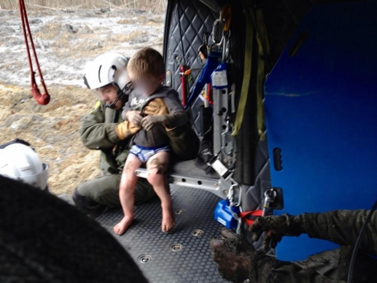
The picture of the four year old boy rescued broke my heart and if I understand correctly the little guy is now alone. Sad, truly a travesty of epic proportions. And all I hear about is looking for a plane that may or may not even be there. That is another tragedy but this one is visible and reachable.
So sorry to hear of your personal issues and hope you are coping as best that you can. This is horrible and I too am wondering why it is not receiving more coverage.
What is wrong with these land developers building on places that are known to have previous or future problems. Why do they build in places that can collapse at a moments notice. These people built or bought homes and were probably unaware of any danger that the location of their home and families were in. This happens everywhere whether your home is on a fault or flood plane is not disclosed prior to the sale. This needs to change and someone needs to pay. Whoever approved of these building sites needs to pay. Shame on them.
The picture of the four year old boy rescued broke my heart and if I understand correctly the little guy is now alone. Sad, truly a travesty of epic proportions. And all I hear about is looking for a plane that may or may not even be there. That is another tragedy but this one is visible and reachable.
reply to post by whatnext21
I cannot imagine that most young families would have lived there if they had known the risk. The reports are coming out about the very high risk of catastrophic failure of that hillside that the state *knew* about. It appears the state is trying to say that a tiny earthquake a few days prior to the slide caused it. The experts are saying that a 1.1 eq in the area would be very unlikely to trigger such an event. I'm not going to say that a tiny eq could not be the final straw but the potential was there to begin with.
The 4 yo boy was reunited with his mother but his siblings are still missing.
reply to post by TrueAmerican
SCGrits 5. USGS EQ map indicating that the community sat squarely on a known small fault line called the Devil's Mt Fault. NO, repeat NO, EQ of any size have been indicated for the area in the last 30 days per USGS. -
OK, my sincere apologies ya'll; I stand corrected; there were no EQ 2.5 & OVER in the last 30 days........BUT there was a 1.1, 3.9 km deep just north of the land slide area, just across the county line, on Monday 10 Mar 2014, 12 days prior. My bad.
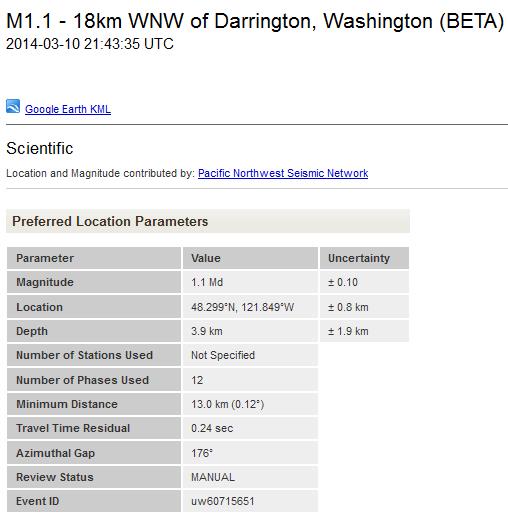
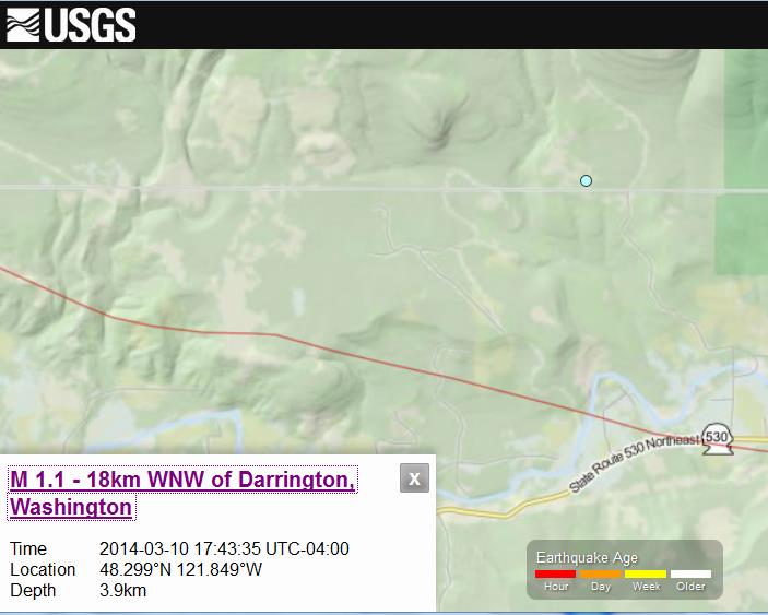
Could a tiny EQ 12 days prior set anything in motion at such a later date?? Or is it just one piece of many in a tragic perfect storm of events?
I feel so sorry for those families that lost loved ones. If government officials refused to use helicopters with no good explanation then the local
and state levels should be sued for their lack of effort. We pay our taxes for a reason! I have a number of distant relatives living up in Washington
and if that happened to them I would fight tooth and nail.
That hillside looked awfully prone to mudslide with the old Google Earth satellite photo. They should never have made that a residential area.
After looking at the Google Image of the area I couldn’t help notice a side profile of a monster’s face. It looks like the horned creature from the movie Time Bandits.
48°16'49.47" N 121°50'47.71" W
The news here seems to be covering more so than national. A local resident has four family members missing - her parents, her daughter and her
daughter's fiance. Last report I saw was 30 houses.
edit on 3/25/2014 by TXTriker because: can't type
Everyone knew. It was known as "Hazel Landslide" for the past half century. A government scientist warned and published the warning 15 yrs ago:
Source
The 1999 report by geomorphologist Daniel Miller raises questions about why residents were allowed to build homes in the area and whether officials had taken proper precautions.
"I knew it would fail catastrophically in a large-magnitude event," though not when it would happen, said Miller, who was hired by the U.S. Army Corps of Engineers to do the study. "I was not surprised."
They can only publish the study, not act on it, no authority.
It is devastating enough to lose one family member never mind a number of them all at one time. This is so tragic. There have been some miraculous
stories of people surviving things you'd never expect them to survive. I can only hope and pray that we have some survivors somewhere.
Video:
Little Jacob made it, but his siblings and family did not, so very sad.
news.yahoo.com...
Little Jacob made it, but his siblings and family did not, so very sad.
Dramatic rescue: 4-year-old boy pulled from mudslide by helicopter
news.yahoo.com...
edit on pm331pmWed, 26 Mar 2014 13:51:41 -0500 by antar
because: (no reason given)
reply to post by MOMof3
These dangerous areas are EVERYWHERE. Volcanoes, Hurricanes, Floods, Earthquakes, Tornadoes, Drought, you name it, dont point the finger at this community, people have lived in that area for generations. Landslides are not uncommon any where and warnings do not stop people from living. Not to be rude but your comment was so insensitive at this point. We are all vulnerable to disasters.
These dangerous areas are EVERYWHERE. Volcanoes, Hurricanes, Floods, Earthquakes, Tornadoes, Drought, you name it, dont point the finger at this community, people have lived in that area for generations. Landslides are not uncommon any where and warnings do not stop people from living. Not to be rude but your comment was so insensitive at this point. We are all vulnerable to disasters.
new topics
-
University of Texas Instantly Shuts Down Anti Israel Protests
Education and Media: 59 minutes ago -
Any one suspicious of fever promotions events, major investor Goldman Sachs card only.
The Gray Area: 3 hours ago -
God's Righteousness is Greater than Our Wrath
Religion, Faith, And Theology: 7 hours ago -
Electrical tricks for saving money
Education and Media: 10 hours ago
top topics
-
VP's Secret Service agent brawls with other agents at Andrews
Mainstream News: 12 hours ago, 10 flags -
Cats Used as Live Bait to Train Ferocious Pitbulls in Illegal NYC Dogfighting
Social Issues and Civil Unrest: 16 hours ago, 8 flags -
Nearly 70% Of Americans Want Talks To End War In Ukraine
Political Issues: 12 hours ago, 4 flags -
Electrical tricks for saving money
Education and Media: 10 hours ago, 4 flags -
Sunak spinning the sickness figures
Other Current Events: 12 hours ago, 3 flags -
Late Night with the Devil - a really good unusual modern horror film.
Movies: 14 hours ago, 2 flags -
Any one suspicious of fever promotions events, major investor Goldman Sachs card only.
The Gray Area: 3 hours ago, 2 flags -
The Good News According to Jesus - Episode 1
Religion, Faith, And Theology: 17 hours ago, 1 flags -
God's Righteousness is Greater than Our Wrath
Religion, Faith, And Theology: 7 hours ago, 0 flags -
University of Texas Instantly Shuts Down Anti Israel Protests
Education and Media: 59 minutes ago, 0 flags
active topics
-
Sunak spinning the sickness figures
Other Current Events • 11 • : McUrnsalso -
Nearly 70% Of Americans Want Talks To End War In Ukraine
Political Issues • 32 • : andy06shake -
Any one suspicious of fever promotions events, major investor Goldman Sachs card only.
The Gray Area • 6 • : ImagoDei -
University of Texas Instantly Shuts Down Anti Israel Protests
Education and Media • 1 • : PorkChop96 -
Reason of the Existence
The Gray Area • 20 • : belkide -
Black mirror, what happened.
Television • 20 • : seekshelter -
God's Righteousness is Greater than Our Wrath
Religion, Faith, And Theology • 25 • : andy06shake -
Russia Ukraine Update Thread - part 3
World War Three • 5730 • : Arbitrageur -
VP's Secret Service agent brawls with other agents at Andrews
Mainstream News • 43 • : Hakaiju -
Everest-sized ‘Devil comet’ Pons-Brooks Visible Now
Space Exploration • 17 • : Compendium