It looks like you're using an Ad Blocker.
Please white-list or disable AboveTopSecret.com in your ad-blocking tool.
Thank you.
Some features of ATS will be disabled while you continue to use an ad-blocker.

Satellite Search Image (Malaysia Airlines Flight MH370)
page: 13
share:
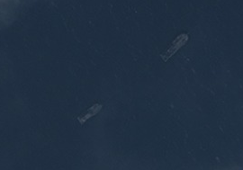
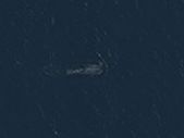
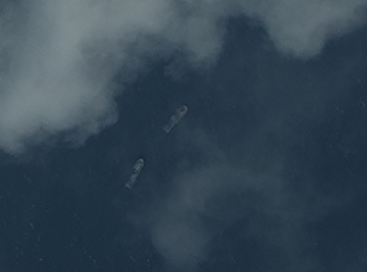
I have been searching through the satellite images provided by: DigitalGlobe
I finally got new images to review from 3/14/2014, after viewing almost 30,000 satellite images from what we now know is the wrong location, this one caught my attention on the newest download. I can't tell from the grid as to where it is coming from... they only give a map # 542598 which is w/o coordinates. Has anyone seen the remaining images yet that locates the source? Tomnod
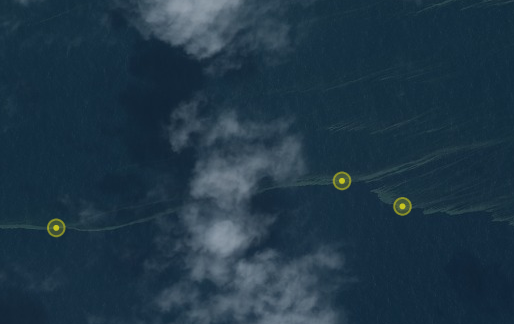
...most of the images I have seen have just been boats:
 ,
,  ,
, 
I finally got new images to review from 3/14/2014, after viewing almost 30,000 satellite images from what we now know is the wrong location, this one caught my attention on the newest download. I can't tell from the grid as to where it is coming from... they only give a map # 542598 which is w/o coordinates. Has anyone seen the remaining images yet that locates the source? Tomnod
...most of the images I have seen have just been boats:
edit on 3/17/2014 by Shdak because: grammer
reply to post by WordsAreAvenues
I hope that turns out to be good news, as far as finding the missing flight... still prayers for the families also. Hopefully this may bring some closure.
I hope that turns out to be good news, as far as finding the missing flight... still prayers for the families also. Hopefully this may bring some closure.
Shdak
I have been searching through the satellite images provided by: DigitalGlobe
I finally got new images to review from 3/14/2014, after viewing almost 30,000 satellite images from what we now know is the wrong location, this one caught my attention on the newest download. I can't tell from the grid as to where it is coming from... they only give a map # 542598 which is w/o coordinates. Has anyone seen the remaining images yet that locates the source? Tomnod
...most of the images I have seen have just been boats:
,,edit on 3/17/2014 by Shdak because: grammer
Why doesn't the US just come clean on the location? The whole area is covered by sat platforms and Diego Garcia, they know exactly where the plane is.
Cheers - Dave
You can find the coordinates fyi of the images on tomnod
1. In the link (URL) bar, change the word “challenge" to “api". You'll get an error message with the latitude and longitude of the image you were at.
2. Follow these instructions to locate the area in Google maps: support.google.com...
Just for future reference
Edit: Or you can just use www.tomnodmaplocator.com...
edit on 17-3-2014 by synnergy because: (no reason given)
reply to post by Shdak
I think what is widely overlooked to date is that when the passengers phones rang the NSA should have known precisely where the nearest transmitter was. All modern phones have tracking devices built into them. The NSA spies on phone calls, that's what they are set up to do. In times like this they could have focused as much of their resources and technology they needed, to participate in helping to locate this plane.
Why have they said and or done nothing? Not committing the required resources onto this disaster implicates the U.S. in the disappearance particularly when there were 20 or so Chinese engineers on board who the U.S may have been watching for some time. The U.S may well have wanted to talk to them before the situation in Ukraine goes hot.
reply to post by Shdak
I had a look at that tomnod last week and couldnt even see hat I was looking at... all I got was a black sat image with a few what looked like waves or clouds but it was way too dark to see anything. I couldnt even zoom in or out...
I had a look at that tomnod last week and couldnt even see hat I was looking at... all I got was a black sat image with a few what looked like waves or clouds but it was way too dark to see anything. I couldnt even zoom in or out...
reply to post by bobs_uruncle
Absolutely. We have microphones all over the sea floor. Our satellites can figure out what type of screw is on the moving wing of a commercial jet liner. Thirty years ago the SR-71 could snap a photo of a golf ball from over 45,000 feet. We can listen in on the German Chancellor and know what Merkel had for breakfast. And, we can put a man on the moon.
Somehow, we can't find a 777? Even with it's transponder off, it would still show as a blip on the radar screen. Go back through the logs and look for a blip without transponder ID info. It's really not that hard. Flocks of birds even show up on radar. Sheesh.
No, the government(s) know exactly where it is. My guess is that it was shot down either on purpose or by accident. The people responsible need time to "clean up" after themselves. Just give it a few more days, they'll miraculously find the wreckage.
MystikMushroom
reply to post by bobs_uruncle
Absolutely. We have microphones all over the sea floor. Our satellites can figure out what type of screw is on the moving wing of a commercial jet liner. Thirty years ago the SR-71 could snap a photo of a golf ball from over 45,000 feet. We can listen in on the German Chancellor and know what Merkel had for breakfast. And, we can put a man on the moon.
Somehow, we can't find a 777? Even with it's transponder off, it would still show as a blip on the radar screen. Go back through the logs and look for a blip without transponder ID info. It's really not that hard. Flocks of birds even show up on radar. Sheesh.
No, the government(s) know exactly where it is. My guess is that it was shot down either on purpose or by accident. The people responsible need time to "clean up" after themselves. Just give it a few more days, they'll miraculously find the wreckage.
If that is the case, it kind of reminds me of the Helderberg. I was running a black ops weapons program for CI (Angolan Theatre of Operations) in South Africa in the 80's, the Chief of CI (my CO) decided to get clever and impatient at the same time and had 18kg's of highly enriched p239 and ammonium perchlorate loaded onto the same commercial airliner (SA295, a 747-244b combi), duh, ya can't fix stupid. He was supposed to fly back with it but he was warned off during baggage check in Taipei and stayed the extra day. The plane went down in 15,000 feet of water about 135nm NE of Mauritius. We expect it was an accelerated fire on board created by a timed altimeter detonator, according to my former CO, but there is always the possibility it was shot down by the US carrier group in the area (that came from a UN op who was quite insistent)) since one of the engines was never found.
It took months to find the plane, but it appears the CIA gave the Sonne (SRO ship) the wrong information, so they searched the wrong area, but they did find some odd pieces a long way from the debris field on the flight path, like a toy car that was on board and a pipe that may have come from an engine. But you know, it gave the CIA and SEALS time to go in and retrieve the p239 to get the NK reactor signature and grab the FDR and CVR (I have the alleged CVR recording) so they could be "sanitized." I actually got the FOIA people in the US to send me ALL the reports, 2 cubic feet worth, a lot of it redacted according to the FOIA office, but it included eavesdropping recordings out of Diego Garcia. The box landed at my local post office and disappeared, go figure, but since CSIS up here in Canadakastan and the Canadian Consul in Pretoria knew what had happened since at least the mid 90's (because I told them), can't have that information floating around.
Something is real "fishy" with this Malaysian flight, we may never know what it is since the cleaning crews have gotten better at their jobs and the mil/industrial complex has a lot better handle on the infotainment news channels.
ATA: The Helderberg was a very sweet target for the PTB, it had people involved in false VOR beacon technology, MI Handlers, ammonium perchlorate for Somchem and PMP Detonics for the accelerated SAMS program and p239 for my EMP project at Atlas, plus the Chief of CI was supposed to flying back on the plane. How they could put that much military material for projects and that many people that knew too much on one plane, especially a commercial airline with 159 innocents, I can't figure out, it's just stupid but it's also criminal.
I wonder what was on the Malaysian flight apart from all those engineers working on DARPA related contracts?
Cheers - Dave
edit on 3/18.2014 by bobs_uruncle because: The ETA
reply to post by MystikMushroom
They have to be within radar range though to get a blip on the radar, in non controlled airspace it won't show up.
They have to be within radar range though to get a blip on the radar, in non controlled airspace it won't show up.
new topics
-
In an Historic First, In N Out Burger Permanently Closes a Location
Mainstream News: 10 minutes ago -
MH370 Again....
Disaster Conspiracies: 42 minutes ago -
Are you ready for the return of Jesus Christ? Have you been cleansed by His blood?
Religion, Faith, And Theology: 2 hours ago -
Chronological time line of open source information
History: 4 hours ago -
A man of the people
Diseases and Pandemics: 5 hours ago -
Ramblings on DNA, blood, and Spirit.
Philosophy and Metaphysics: 5 hours ago -
4 plans of US elites to defeat Russia
New World Order: 7 hours ago -
Thousands Of Young Ukrainian Men Trying To Flee The Country To Avoid Conscription And The War
Other Current Events: 10 hours ago
top topics
-
Israeli Missile Strikes in Iran, Explosions in Syria + Iraq
World War Three: 14 hours ago, 17 flags -
Thousands Of Young Ukrainian Men Trying To Flee The Country To Avoid Conscription And The War
Other Current Events: 10 hours ago, 7 flags -
Iran launches Retalliation Strike 4.18.24
World War Three: 13 hours ago, 6 flags -
12 jurors selected in Trump criminal trial
US Political Madness: 13 hours ago, 4 flags -
4 plans of US elites to defeat Russia
New World Order: 7 hours ago, 4 flags -
A man of the people
Diseases and Pandemics: 5 hours ago, 3 flags -
Chronological time line of open source information
History: 4 hours ago, 2 flags -
In an Historic First, In N Out Burger Permanently Closes a Location
Mainstream News: 10 minutes ago, 2 flags -
Are you ready for the return of Jesus Christ? Have you been cleansed by His blood?
Religion, Faith, And Theology: 2 hours ago, 1 flags -
Ramblings on DNA, blood, and Spirit.
Philosophy and Metaphysics: 5 hours ago, 1 flags
active topics
-
Not Aliens but a Nazi Occult Inspired and then Science Rendered Design.
Aliens and UFOs • 14 • : Caver78 -
Thousands Of Young Ukrainian Men Trying To Flee The Country To Avoid Conscription And The War
Other Current Events • 18 • : Xtrozero -
-@TH3WH17ERABB17- -Q- ---TIME TO SHOW THE WORLD--- -Part- --44--
Dissecting Disinformation • 540 • : IndieA -
12 jurors selected in Trump criminal trial
US Political Madness • 37 • : iaylyan -
Scarface does Tiny Desk Concert
Music • 8 • : zosimov -
In an Historic First, In N Out Burger Permanently Closes a Location
Mainstream News • 0 • : underpass61 -
4 plans of US elites to defeat Russia
New World Order • 28 • : Oldcarpy2 -
Israeli Missile Strikes in Iran, Explosions in Syria + Iraq
World War Three • 72 • : DBCowboy -
Fossils in Greece Suggest Human Ancestors Evolved in Europe, Not Africa
Origins and Creationism • 67 • : strongfp -
Are you ready for the return of Jesus Christ? Have you been cleansed by His blood?
Religion, Faith, And Theology • 10 • : TruthJava
3