It looks like you're using an Ad Blocker.
Please white-list or disable AboveTopSecret.com in your ad-blocking tool.
Thank you.
Some features of ATS will be disabled while you continue to use an ad-blocker.

Map shows 634 runways in range of missing Malaysia Airlines plane
page: 17
share:
THIS map shows the 634 runways across 26 countries that the missing Malaysia Airlines plane could have landed on.
The infographic shows where the plane could be if it had successfully touched at a secret location — one of the many theories floating round as the mystery enters a second week.
Boeing 777s need a runway to be at least 1524 metres long, limiting the number of possible sites.
The map – put together by the Data News team at WNYC – shows all the possible runways the plane could have reached if it had flown for a maximum of five hours.
Map shows 634 runways in range of missing Malaysia Airlines plane
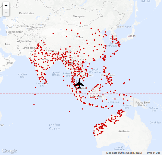
The map above shows all the possible landing strips Malaysia Airlines flight 370 could have landed on. With this said, the media has been saying that the plane was airborne for an extra seven hours upon the hour or two it would have taken to get to Vietnam and turn around again (which is probably unlikely due to fuel). If that claim is true, then the plane could have reached further beyond what is marked on the above map.
Eliminate all the ones in countries with RADAR that would of picked it up if it went far inland, so it would need to be coastal so it could fly in low
enough with out causing such a ruckus flying over populated areas below radar.
and I would add countries with "contested" air space, or ones that have a history of conflict who would be paranoid about air traffic.
and I would add countries with "contested" air space, or ones that have a history of conflict who would be paranoid about air traffic.
edit on
16-3-2014 by benrl because: (no reason given)
Id argue that this is ATS....where are the places it could land that are out of the box ideas and not on that map!!!!!!? Like some rushed landing
site in the middle of no where.
Good map though OP
Good map though OP
edit on 16-3-2014 by cosmicexplorer because: (no reason given)
Yeah, the plane could be anywhere. If there was an organised group behind the hijacking, i wouldn't be surprised if they had constructed their own
landing strip..
That being said, i thought the map above was worth putting on here, as it at least gives us a fair idea of the range of the plane, and where it could be.
Thanks for the comments!
That being said, i thought the map above was worth putting on here, as it at least gives us a fair idea of the range of the plane, and where it could be.
Thanks for the comments!
That's about a mile long. I assume it would have to be paved and kept in pretty good in condition for this aircraft to land safely? That might
narrow this list down some.
So it could have landed on that alleged chinese remote outpost, interesting. Its most likely that it would stop shorter, but would require a very
experienced specialist pilot, which I dont believe is the case.
Narrows the field if nothing else.
Narrows the field if nothing else.
reply to post by daaskapital
Successfully navigating TO one of those runways, even if predetermined, is the hard part.
I don't think people realize how hard that would be.
Flying an aircraft at designated speed to a very small point on earth and aligned properly for descent BY ITSELF (or even with help from the port/strip) would be very difficult without on board navigation assistance (which would likely mean tracking).
reply to post by daaskapital
Very interesting !
I read that it could have flown for up to seven and a half hours (according to last ping) and that it could have gone as far up as Kazakhstan...
That would put a few hundred more dots on that map !!
S&F.
Very interesting !
I read that it could have flown for up to seven and a half hours (according to last ping) and that it could have gone as far up as Kazakhstan...
That would put a few hundred more dots on that map !!
S&F.
reply to post by daaskapital
But does that map include abandoned runways on islands that were used as bases by either the Allies or Axis during WWII?
With all the obvious preparations such a hijacking required, it wouldn't be much of a stretch to extend the length of one to accommodate 4500 feet, which I hear is the minimum length for a 777.
reply to post by masqua
most of those wouldn't be long enough to take a 777, hell some modern airports can't.
That would narrow the search some.
most of those wouldn't be long enough to take a 777, hell some modern airports can't.
That would narrow the search some.
reply to post by daaskapital
I think all but a few of the landing strips shown in Australia need to be removed because they would not be able to handle a 777. They are all 2 kilometre strips but then again I could be wrong about a 777 not being able to land on a 2 k strip
I think all but a few of the landing strips shown in Australia need to be removed because they would not be able to handle a 777. They are all 2 kilometre strips but then again I could be wrong about a 777 not being able to land on a 2 k strip
learnatic
reply to post by daaskapital
I think all but a few of the landing strips shown in Australia need to be removed because they would not be able to handle a 777. They are all 2 kilometre strips but then again I could be wrong about a 777 not being able to land on a 2 k strip
they were on the news saying 1km would be enough to land a plane.
Hey does anyone know the software the pilot was using on his simulator?
masqua
But does that map include abandoned runways on islands that were used as bases by either the Allies or Axis during WWII?
It includes the ocean, which would be a hell of a lot safer to crash into than a 70yo airstrip.
reply to post by amraks
1 Interesting to know.
2 Who knows what software but I think this is a furphy anyway. For me the question is why are the 'experts' interviewed on TV are always American, do asian counteries not have aviation experts? What does this tell us? When the US government blames the pilots, I smell a rat. I think they have put a lot of thought into this.
learnatic
I think all but a few of the landing strips shown in Australia need to be removed because they would not be able to handle a 777. They are all 2 kilometre strips but then again I could be wrong about a 777 not being able to land on a 2 k strip
There is a lot of airstrips for farming interests which handle 2-10 seaters. There are quite a few for commercial flights for workers but they're not commercial jet size.
Either way, any airstrip cpable of handling a jet has radar and people with communications more high tech than mail. If it landed you would know about it minutes later.
The North of Australia has some serious radar monitoring, right down to sea level, so I would doubt this is a likely scenario.
ressiv
reply to post by daaskapital
the map shows NOT Diego Garcia base....
Yeah it does, it's the furthest south west dot.
The one that's far further away than all the other options and unlike those has air defence.
The big blue area surrounding the red dots being a far bigger target. Has no air traffic controllers and maint staff with cell phones.
new topics
-
Former Labour minister Frank Field dies aged 81
People: 21 minutes ago -
SETI chief says US has no evidence for alien technology. 'And we never have'
Aliens and UFOs: 2 hours ago -
This is our Story
General Entertainment: 4 hours ago -
President BIDEN Vows to Make Americans Pay More Federal Taxes in 2025 - Political Suicide.
2024 Elections: 6 hours ago -
Ode to Artemis
General Chit Chat: 7 hours ago -
Ditching physical money
History: 11 hours ago -
One Flame Throwing Robot Dog for Christmas Please!
Weaponry: 11 hours ago -
Don't take advantage of people just because it seems easy it will backfire
Rant: 11 hours ago
top topics
-
University student disciplined after saying veganism is wrong and gender fluidity is stupid
Education and Media: 15 hours ago, 14 flags -
President BIDEN Vows to Make Americans Pay More Federal Taxes in 2025 - Political Suicide.
2024 Elections: 6 hours ago, 10 flags -
One Flame Throwing Robot Dog for Christmas Please!
Weaponry: 11 hours ago, 6 flags -
Should Biden Replace Harris With AOC On the 2024 Democrat Ticket?
2024 Elections: 13 hours ago, 6 flags -
Don't take advantage of people just because it seems easy it will backfire
Rant: 11 hours ago, 4 flags -
Ditching physical money
History: 11 hours ago, 4 flags -
SETI chief says US has no evidence for alien technology. 'And we never have'
Aliens and UFOs: 2 hours ago, 3 flags -
God lived as a Devil Dog.
Short Stories: 16 hours ago, 3 flags -
Ode to Artemis
General Chit Chat: 7 hours ago, 2 flags -
VirginOfGrand says hello
Introductions: 12 hours ago, 2 flags
active topics
-
Former Labour minister Frank Field dies aged 81
People • 2 • : Freeborn -
Terrifying Encounters With The Black Eyed Kids
Paranormal Studies • 72 • : Consvoli -
The Superstition of Full Moons Filling Hospitals Turns Out To Be True!
Medical Issues & Conspiracies • 24 • : angelchemuel -
SETI chief says US has no evidence for alien technology. 'And we never have'
Aliens and UFOs • 13 • : andy06shake -
"We're All Hamas" Heard at Columbia University Protests
Social Issues and Civil Unrest • 266 • : KrustyKrab -
Russia Ukraine Update Thread - part 3
World War Three • 5720 • : Freeborn -
University student disciplined after saying veganism is wrong and gender fluidity is stupid
Education and Media • 32 • : BedevereTheWise -
So this is what Hamas considers 'freedom fighting' ...
War On Terrorism • 227 • : HopeForTheFuture -
Remember These Attacks When President Trump 2.0 Retribution-Justice Commences.
2024 Elections • 51 • : Justoneman -
British TV Presenter Refuses To Use Guest's Preferred Pronouns
Education and Media • 131 • : FlyersFan
7