It looks like you're using an Ad Blocker.
Please white-list or disable AboveTopSecret.com in your ad-blocking tool.
Thank you.
Some features of ATS will be disabled while you continue to use an ad-blocker.

Missing Plane 'Flown Towards Andaman Islands'
page: 9share:
cheekybobo
Could the plane have made it south to Australia? There is plenty of room here to land a plane and no one would know.
Yes, it could have made it to Australia:
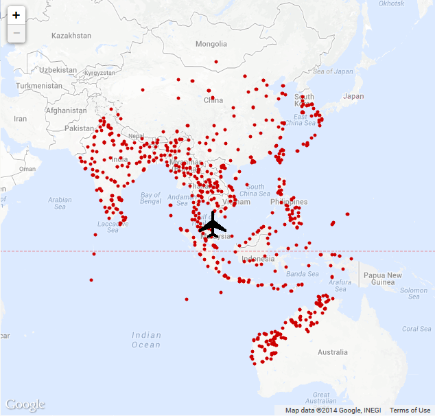
The above map shows all landing strips of which the plane could have landed on in the event of the plane being airborne for a maximum of 5 hours.
I think we would have noticed if it came to Australia though. I'm sure we would have a lot of tech pointing north, which would also likely be able to capture any misguided plane. That being said though, you are correct that no one would know if the plane had actually landed here without raising suspicion.
With this story, i've mostly maintained that the plane could have landed in Indonesia, as we all know how great their defensive procedures are, and their abilities to pick up objects on radar...not to mention that Indonesia is full of terrorists and is also able to hide a 777. But, i'm not sure what to think of that anymore, considering we know the plane was heading North-West before completely and indefinitely disappearing.
edit on 16-3-2014 by daaskapital because: (no reason given)
daaskapital
I think we would have noticed if it came to Australia though. I'm sure we would have a lot of tech pointing north, which would also likely be able to capture any misguided plane.
Depends if they are in on it or not!..
Australia wouldn't be able to pull it off on its own, I don't think we could trick ol Harold Holt!
A government took this plane..
All i hear about in the news is the flight crew, maybe a stow away, a rogue passenger... the media wants you to believe the only way it could have done this is if it was done by someone on-board!
Which government?..If you commit a crime like this you make sure the story comes out your way!.. one of the top 4 governments involved in this search,must have taken it!
twenty or so technical specialists who may have been contracted to the US government research and development groups
Granted, I just started getting into this case after the deliberate vanishing became apparent, but this point certainly fits the effort pretty well. The biggest piece of info here is that they obviously wanted the plane intact, so either something or someone on the plane.
A team who work for a company specializing in advanced electronics? Sounds like something out of a Bond film, but so do these facts so far.
andy1972
How many times are these bufoons going to change the story.
Here's the deal.
Malaysia Airlines flight MH370 was demolecularized into dust as were 9/11 flights AA11, AA77, UA93, and UA175.
The difference between the two cases is that the 9/11 demolecularizations were preplanned, and so the powers-that-be had their stories prepared although less than perfectly.
The MH370 demolecularization was inadvertent, possibly because some other target was intended or because of Lord-knows-what reasons.
Because the circumstances and theater of the MH370 were far outside the control of the U.S., it took the U.S. days to start coming out with stories that made little sense while presenting much conflicting information that was challenged by others, particularly experts on CNN.
Don't believe any of the tracking data pertaining to flight MH370.
The United States is presenting a search area so huge that it presents an impossible search. Then the U.S. can say that they made their best efforts, but the area to be searched created too much of a challenge to find anything when they know full well that there is nothing to be found.
me
edit on 17-3-2014 by theworldisnotenough because: (no reason given)
edit on 17-3-2014 by theworldisnotenough because: typos
fixed
Although there is no solid facts about how many seats were "intentionally" empty it seems fact that there was some need for some extra cargo which im
guessing could be fuel. The choice being a 777-200 is interesting given its slimmer body, very fuel efficient, uses a fly by wire system (lighter).
Therefore it seems that if it was hijacked the aim is to fly as far as possible with as little weight as possible without flagging interest. Looking
at this site ( project.wnyc.org... ), they provide the possible landing site within the perimeter (determined by its furthest normal ability to fly).
However it could be strange that right on the edge of the perimeter of the max flight distance is the british indian ocean territory base with a
landing site. Also for the terror links there is north korea, Afghanistan and iran.
I just see a link to this choice of fuel efficient plane and need for extra flight distance and need to reach somewhere on the periphery of the usual max flying time.
Update.
Furthermore looking at the last known route of the plane you see it taking off from malaysia flying in direction of thialand and then abruptly trun towards the area where the british indian territory base is situated and then lose radar signal .
This would maybe make sense why the tracking on radar isnt showing much. With this base location also the location of the radar so thus withhold this information. British the american lapdogs creates a huge distraction once again to create fear and in turn chip away at our freedoms
edit on
17-3-2014 by liteonit6969 because: (no reason given)
Vasa Croe
Looking more and more like the pilot had something to do with this. Zaharie Ahmad Shah....family moved out the day before the flight....Shah just happens to mean "former monarch of Iran".
Following that logic, Martin Luther King Jr would correlate with the "former monarch of England." OMG, maybe we're on to something...
I'm still trying to decipher what you're trying to imply.
WatchingFromtheShadows
Vasa Croe
Looking more and more like the pilot had something to do with this. Zaharie Ahmad Shah....family moved out the day before the flight....Shah just happens to mean "former monarch of Iran".
Following that logic, Martin Luther King Jr would correlate with the "former monarch of England." OMG, maybe we're on to something...
I'm still trying to decipher what you're trying to imply.
Nothing to decipher....this is an operation that will tie to Iran.
reply to post by daaskapital
If todays' efforts in the Indian Ocean don't come to fruition, I highly suggest
'someone' needs to take a good look at the bottom portion of Little Andaman Island.
Off the west coast side....right near said coast. I've been trying to draw attention to some sort of possible plane tragedy that I may've picked up on through satellite imagery, along that forested area. It could be from an older crash...or not. Needs a look, though.
linda1mom
reply to post by daaskapital
If todays' efforts in the Indian Ocean don't come to fruition, I highly suggest
'someone' needs to take a good look at the bottom portion of Little Andaman Island.
Off the west coast side....right near said coast. I've been trying to draw attention to some sort of possible plane tragedy that I may've picked up on through satellite imagery, along that forested area. It could be from an older crash...or not. Needs a look, though.
Apparently your pictures in your other thread were taken a while ago, 2012 and before. At least that is what another member has found. Member posted a link in that thread.
reply to post by Vasa Croe
There is no way to tell when the images were taken as that individual realizes...but the fact remains that in my photos, there is a downed aircraft. Trees don't look like the image and certainly don't fall like that. Again, whether it is Malaysia or a past crash, it needs to be looked at.
There is no way to tell when the images were taken as that individual realizes...but the fact remains that in my photos, there is a downed aircraft. Trees don't look like the image and certainly don't fall like that. Again, whether it is Malaysia or a past crash, it needs to be looked at.
reply to post by linda1mom
I guess you didn't look at my link?
It showes when the images were taken.
I guess you didn't look at my link?
It showes when the images were taken.
reply to post by linda1mom
let me repost it incase you missed it
let me repost it incase you missed it
EvilBat
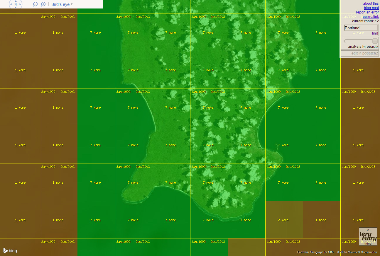
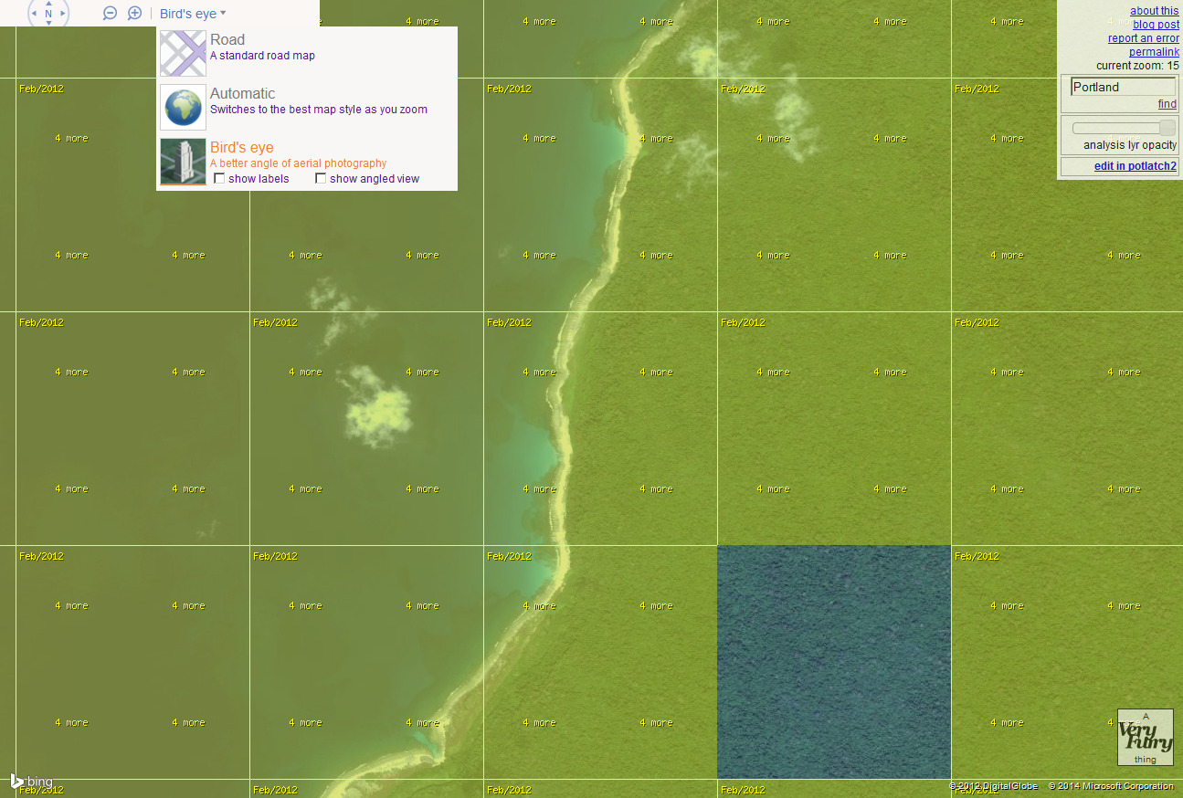
The images on BIng / Yahoo For flash earth for this area that is in interest were taken Feb 2012
The Higher alt picts of the island were taken ruffly Jan 1999 to Dec 2003 in those dates
even higher alt is july 2004
Info gotten from Bing Imagery Analyzer "is a site showing bing satellite and aerial photos overlaid with their capture date."
whech can be found here Link
reply to post by EvilBat
Your link was NOT on Little Andaman Island. I guarantee it. That is where my images DO come from. There are nowhere near that much housing or even farmland.
Your link was NOT on Little Andaman Island. I guarantee it. That is where my images DO come from. There are nowhere near that much housing or even farmland.
reply to post by linda1mom
just go to the island and look.
in the post above I posted screenshots for you too
just go to the island and look.
in the post above I posted screenshots for you too
reply to post by EvilBat
Certainly not what that link shows. The images you sent just before are.
and like I've said for the 20th time...there is a plane in that forest. It needs to be looked at regardless.
RAe we all trying to help or just jumping on the bandwagon to taunt those who are?..Unreal.
Certainly not what that link shows. The images you sent just before are.
and like I've said for the 20th time...there is a plane in that forest. It needs to be looked at regardless.
RAe we all trying to help or just jumping on the bandwagon to taunt those who are?..Unreal.
I'm not faulting you for trying to help
I'm just pointing out that the Images are from years ago.
There is no band wagon to jump on either.
yes there could be something in the forest but it would be years old
and defenatly not what people are looking for right now.
Yes you are right my link does not directly link to the map of the island
but really you can't just click and drag over to it?
new topics
-
University of Texas Instantly Shuts Down Anti Israel Protests
Education and Media: 2 hours ago -
Any one suspicious of fever promotions events, major investor Goldman Sachs card only.
The Gray Area: 4 hours ago -
God's Righteousness is Greater than Our Wrath
Religion, Faith, And Theology: 8 hours ago -
Electrical tricks for saving money
Education and Media: 11 hours ago
top topics
-
VP's Secret Service agent brawls with other agents at Andrews
Mainstream News: 13 hours ago, 10 flags -
Cats Used as Live Bait to Train Ferocious Pitbulls in Illegal NYC Dogfighting
Social Issues and Civil Unrest: 17 hours ago, 8 flags -
Nearly 70% Of Americans Want Talks To End War In Ukraine
Political Issues: 13 hours ago, 4 flags -
Sunak spinning the sickness figures
Other Current Events: 13 hours ago, 4 flags -
Electrical tricks for saving money
Education and Media: 11 hours ago, 4 flags -
Late Night with the Devil - a really good unusual modern horror film.
Movies: 15 hours ago, 2 flags -
Any one suspicious of fever promotions events, major investor Goldman Sachs card only.
The Gray Area: 4 hours ago, 2 flags -
University of Texas Instantly Shuts Down Anti Israel Protests
Education and Media: 2 hours ago, 1 flags -
God's Righteousness is Greater than Our Wrath
Religion, Faith, And Theology: 8 hours ago, 0 flags
active topics
-
Sunak spinning the sickness figures
Other Current Events • 16 • : Freeborn -
President BIDEN Vows to Make Americans Pay More Federal Taxes in 2025 - Political Suicide.
2024 Elections • 139 • : xuenchen -
Nearly 70% Of Americans Want Talks To End War In Ukraine
Political Issues • 47 • : andy06shake -
University of Texas Instantly Shuts Down Anti Israel Protests
Education and Media • 9 • : Vermilion -
Should Biden Replace Harris With AOC On the 2024 Democrat Ticket?
2024 Elections • 50 • : YourFaceAgain -
New whistleblower Jason Sands speaks on Twitter Spaces last night.
Aliens and UFOs • 57 • : baablacksheep1 -
HORRIBLE !! Russian Soldier Drinking Own Urine To Survive In Battle
World War Three • 39 • : crayzeed -
British TV Presenter Refuses To Use Guest's Preferred Pronouns
Education and Media • 147 • : Annee -
So this is what Hamas considers 'freedom fighting' ...
War On Terrorism • 260 • : network dude -
Hate makes for strange bedfellows
US Political Madness • 43 • : network dude