It looks like you're using an Ad Blocker.
Please white-list or disable AboveTopSecret.com in your ad-blocking tool.
Thank you.
Some features of ATS will be disabled while you continue to use an ad-blocker.

Underwater Harbors in America...7000 years old, history rewritten, atlantis everywhere?
page: 5share:

hey harte
how come this stuff is not a featureless plane
shouldn't those river channels be all mushy by now..its been a while?
www.theguardian.com...
so what do you think of the archeologist who put people in that part of florida at the time mentioned
i thought that was way to early for you
Ancient CAUCASIAN Bog Mummies Found in Windover Florida -
now i wonder whats going on here...ooh an anthropologist..an expert on bog mummies...
dramatic wear on the teeth...not a modern burial...thousands of years ago....
hmmm....
tested over 7000 years old....
la dada dee doobie da da
caucasion ? still waiting on that...
its a cemetary...no ceramics, so its older then ceramics...just bone and antler....
you couldn't ask for a better preservation medium
mysterious sunstance covering the bodies...7000 year old hand woven fabric
a textile the oldest fabric found in north america
brain dna modern methods not avaliable at the original time
no native haplogroups!
he says it looks european
he said earlier from the time of mr cocain and tobacco himself ...king tut
maybe thor hyrdahl was waay ahead of his time....after all
how come this stuff is not a featureless plane
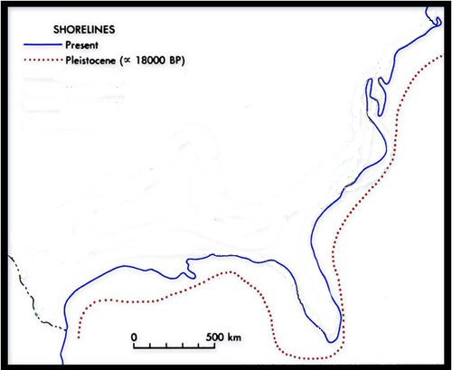
A lost landscape where early humans roamed more than 12,000 years ago has been uncovered beneath the North Sea. A map of the underwater world reveals criss-crossing rivers, giant lakes and gentle hills around which hunter-gatherers made their homes and found their meals toward the end of the last ice age.
The region was inundated between 18000 and 6000BC, when the warming climate melted the thick glaciers that pressed down from the north.
shouldn't those river channels be all mushy by now..its been a while?
www.theguardian.com...
so what do you think of the archeologist who put people in that part of florida at the time mentioned
i thought that was way to early for you
Ancient CAUCASIAN Bog Mummies Found in Windover Florida -
now i wonder whats going on here...ooh an anthropologist..an expert on bog mummies...
dramatic wear on the teeth...not a modern burial...thousands of years ago....
hmmm....
tested over 7000 years old....
la dada dee doobie da da
caucasion ? still waiting on that...
its a cemetary...no ceramics, so its older then ceramics...just bone and antler....
you couldn't ask for a better preservation medium
mysterious sunstance covering the bodies...7000 year old hand woven fabric
a textile the oldest fabric found in north america
edit on 9-3-2014 by Danbones because: (no reason given)
edit on 9-3-2014 by Danbones because: (no reason given)
brain dna modern methods not avaliable at the original time
no native haplogroups!
he says it looks european
he said earlier from the time of mr cocain and tobacco himself ...king tut
edit on 9-3-2014 by Danbones because: (no reason given)
maybe thor hyrdahl was waay ahead of his time....after all
edit on 9-3-2014 by Danbones because: (no reason given)
wow this site is LOADED
canals fish ponds circular ringed irrigation canals on hills reminiscent of plato's description of atlantis
photos, satellite measurements...phds...
seems to show lots of ancient undredged remains of canals and works of all kinds
must all be army core of engineers
www.atlantisbolivia.org...
i left some descriptions in because they seem to be allowing for what is modern and what is not
contrary to some opinions
canals fish ponds circular ringed irrigation canals on hills reminiscent of plato's description of atlantis
photos, satellite measurements...phds...
seems to show lots of ancient undredged remains of canals and works of all kinds
must all be army core of engineers
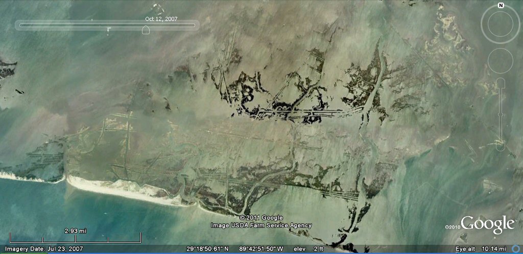
Earlier studies using high resolution Google earth satellite imagery shows extensive remains of ancient canals, ponds, artificial islands and harbours all along the banks of the rivers Parana, Paraguay, Amazon, the Pantanal, Tabasco in Mexico and the Louisiana seaboard. The Louisiana canals are gradually being submerged by the waters of the Gulf of Mexico as a result of the numerous canals created by oil exploration companies which also makes it difficult to distinguish between ancient canals and those of modern times in the Louisiana zone.
Some views from Google Earth...
double lane ancient canal underwater Louisiana
Above, sunken canal complex on the Louisiana seaboard. These seem to be mostly former oil comany canals, some used for oil pipelines and other for access to drilling and exploration rigs. see Louisiana canals page
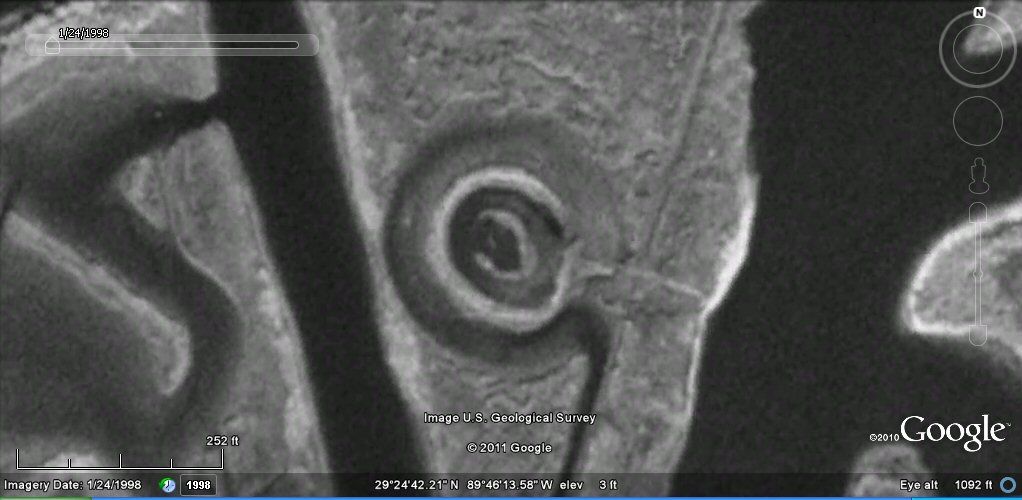
circular harbour Louisiana
Above, amongst the oil company canal complexes, there are intriguing sites such as this one which looks like circular harbour complex from ancient times.
www.atlantisbolivia.org...
i left some descriptions in because they seem to be allowing for what is modern and what is not
contrary to some opinions
edit on 9-3-2014 by Danbones because: (no reason given)
edit on 9-3-2014 by Danbones because: (no reason given)
reply to post by stormcell
ok so where are these other species coming from? where are their progenitors? I don't understand why more people aren't interested in things like actual skulls or submerged man made structures that can tell us so much about our origins. I just can't help but think embracing this is too uncomfortable for a lot of people.
ok so where are these other species coming from? where are their progenitors? I don't understand why more people aren't interested in things like actual skulls or submerged man made structures that can tell us so much about our origins. I just can't help but think embracing this is too uncomfortable for a lot of people.
Harte
bottleslingguy
reply to post by Danbones
Harte has no idea what he's talking about concerning these things. The size of the area containing these structures is so large any attempt at that scale would be the biggest undertaking ever imagined. They are found in areas where the Army Corps hasn't bothered to even think about going and for no good reason anyway. Some people act like authorities on this subject, but they've not spent one minute studying them and deep down inside they know they've waisted their lives studying the wrong things. I think there are going to be a lot of bitter archaeologists just around the corner, so we have to prepare for the angry responses.
Oh, yes, magically self-dredging permanent canals.
Harte
which ones are you talking about? Louisiana? Texas? Florida? the entire East Coast of the US? which ones do the Army Corps dredge? How about the Little Egg Harbor Inlet in NJ? do they dredge that all the time? I'll betcha million dollars they don't so can you explain how they show up there? it's almost as if they dredged themselves!
Seriously, instead of just pretending to be smart on this subject please be a little more specific as to what you are talking about. This is your moment to shine and win some points around here. Show us proof of the Army Corps of Engineers dredging this entire system of obviously man made submerged formations. Take your pick where to start but make sure you include the full scope or else you are just playing games.
i agree
a lot of people have investments in their education, religion, nationality, and culture...
if all that gets proved wrong where will they be...
we should be nice and not rock the boat...just be complacent...maybe go to heaven when we die
or maybe not...
awe heck no..
i say give am hell and damn the torpedoes...if they go into shock a little...
thats what man invented well aged archaeological whiskey for
reply to post by Danbones
The support provided for this stupid idea is a series of Google Earth pics.
The "researcher" is a guy that posts shots from Google Earth and makes inane claims about them without even trying to find out if what he is seeing is modern or not.
So, no I don't "have to" do this, since the guy making the claims is not.
As you might expect, this particular subject has been discussed many times here at ATS (among other websites.) Unless you are completely uninterested, I suggest you read some of those threads.
Harte
bottleslingguy
which ones are you talking about? Louisiana? Texas? Florida? the entire East Coast of the US? which ones do the Army Corps dredge? How about the Little Egg Harbor Inlet in NJ? do they dredge that all the time?
No. Just enough to keep it open.
Link to Corp dredging operations - Little Neck Harbor Inlet
bottleslingguySeriously, instead of just pretending to be smart on this subject please be a little more specific as to what you are talking about. This is your moment to shine and win some points around here. Show us proof of the Army Corps of Engineers dredging this entire system of obviously man made submerged formations. Take your pick where to start but make sure you include the full scope or else you are just playing games.
The search function here is difficult. Try this:
Link to a site-specific Google search of ATS on this subject.
That's more that the owner of the linked "ancient canal system" website has done to support his claim. Why is more required of me?.
Harte
Raised just a meter or two above the water line, all of the islands are fixed in place, Chmura said. They are all oriented in the same direction. And they all have a high point in the same place. Based on those patterns, scientists have long suspected that people somehow influenced their formation.
Evidence for that theory first came in 2005, when archaeologist Margo Schwadron began excavating on some of the islands and found 42 archaeological sites that were full of human garbage. These trash mounds, or middens, contained ceramics, seeds and lots of animal bones, among other types of domestic debris.
The oldest scraps dated back more than 5,000 years, which blew away previous estimates that people first settled the Everglades just 500 to 1,000 years ago. Except for a period of yet-to-be explained abandonment between 4,400 and 2,700 years ago, the area remained populated for millennia.
news.discovery.com...
funny magical self shoring little berm islands i foot out of the water
you'd think they would have collapsed into nothing thousands of years ago
reply to post by tallcool1
I have long believed that history, as is taught to us, is filled with holes
That's because your spirit tells you the truth. (LONG BELIEVED)is your clue...and as we can all see the ones ruling now have holes in just about everything they do... They cant even do false flag operations correctly..lmao. The rulers Definitely are not the brightest bulbs on the pagan xmas tree.
reply to post by Harte
they're doing that as a result of Sandy, these things have been there much longer than that AND much more extensively along the entire east coast. there are actually modern developments on top of parts of existing structures that go out into the water at depths. Look into the marshes in that area. You can easily distinguish the natural creeks caused by the ebb and flow of the tides but there are also grid patterns all over the place and straight lines at straight angles to one another. Not from dredging, animals or people draining fields. If they were man made at one time how have they not grown in after an obviously long amount of time. No one maintains them and you'd have to in order to keep them clear of weeds. They are all over the area but have no purpose nor does anyone dredge them so they must dredge themselves. That's another interesting aspect to this: what keeps them from being covered with sediment and growth? The patterns are all over the place yet no one is dredging marsh areas. You can find long straight canals that go for miles yet no one can claim responsibility. You are not even coming close to the scale involved.
they're doing that as a result of Sandy, these things have been there much longer than that AND much more extensively along the entire east coast. there are actually modern developments on top of parts of existing structures that go out into the water at depths. Look into the marshes in that area. You can easily distinguish the natural creeks caused by the ebb and flow of the tides but there are also grid patterns all over the place and straight lines at straight angles to one another. Not from dredging, animals or people draining fields. If they were man made at one time how have they not grown in after an obviously long amount of time. No one maintains them and you'd have to in order to keep them clear of weeds. They are all over the area but have no purpose nor does anyone dredge them so they must dredge themselves. That's another interesting aspect to this: what keeps them from being covered with sediment and growth? The patterns are all over the place yet no one is dredging marsh areas. You can find long straight canals that go for miles yet no one can claim responsibility. You are not even coming close to the scale involved.
edit on 9-3-2014 by
bottleslingguy because: (no reason given)
reply to post by Harte
a couple of those links are similar subjects to this one both for and against
i don't see how that reflects on this thread to day
considering i linked to photos and comments where they distinguish between older and more modern harbor and canal sites
you missed those?
umm, most of those links were not even relevant to the subject at hand?
but i suppose its all you have now the working celtic cross has demolished your ancient theories about ancient theories
like the white man in florida in the time frame in the op
right there again you are sunk on that one
am i to understand you thought man was only in florida recently like a 1000 years ago
and he wasn't white
oh waitheres more
heres some ancient canals for you
www.viewzone.com...
in boliva which is in an america and they are ancient and there was a harbour there...
from the above link
betcha that keeps the old guard historians awake at night...fretting
The search function here is difficult. Try this:
Link to a site-specific Google search of ATS on this subject.
That's more that the owner of the linked "ancient canal system" website has done to support his claim. Why is more required of me?.
a couple of those links are similar subjects to this one both for and against
i don't see how that reflects on this thread to day
considering i linked to photos and comments where they distinguish between older and more modern harbor and canal sites
you missed those?
umm, most of those links were not even relevant to the subject at hand?
but i suppose its all you have now the working celtic cross has demolished your ancient theories about ancient theories
like the white man in florida in the time frame in the op
right there again you are sunk on that one
am i to understand you thought man was only in florida recently like a 1000 years ago
and he wasn't white
oh waitheres more
heres some ancient canals for you
It is interesting to note that the canals were constructed in a well planned and artistic pattern. This further indicated the intellect and aesthetic appreciation of this culture.
How old is this site?
The age of Tiahuanaco is difficult to assess and very controversial. Polish-born Bolivian archaeologist Arturo Posnansky has concluded that the Tiahuanaco culture began in the region at about 1600 B.C. and flourished until at least 1200 A.D. His disciple, Professor Hans Schindler-Bellamy, believed Tiahuanaco to have reached back 12,000 years before the present era, although a more conservative Peruvian archaeologist. More recently, other archaeologists have pushed back the date to an amazing 14,000 years ago.
The controversy arises because most of the datable artifacts are from the more recent past, while the stone megaliths and other structures do not lend themselves to dating techniques like Carbon 14. Many stone pieces have been uncovered from more than six feet of earth. The mountain ranges which surround the area are not high enough to permit sufficient runoff of water or wind erosion to have covered the ruins to such a depth. This suggests a very old date as the accumulation of sediment is slow in this arid land.
There is also evidence that architectural structures exist at the bottom of Lake Titicaca, suggesting that the civilization existed before the lake was formed. Many scientists believe that the lake formed during some great flood and find similar legends around the world of a flood dating back thousands of years. The local legend contains reference to this flood in their creation myth.
www.viewzone.com...
edit on 9-3-2014 by Danbones because: (no reason given)
in boliva which is in an america and they are ancient and there was a harbour there...
One of the construction blocks from the pier was fashioned from a stone block that weighs an estimated 440 tons
from the above link
betcha that keeps the old guard historians awake at night...fretting
edit on 9-3-2014 by Danbones because: (no reason given)
reply to post by Danbones
We used to have a cottage up there "Oliphant" anyways we had to go to Wiarton to get groceries and such and that area is amazing for being so raw and untouched.
I vividly recall scaling or hiking up the cliffs just north of Wiarton and just shocked at the ancient feel the place had, all the while knowing that the water level was higher than where I was standing at one time.
Beautiful area full of secrets just like you found.
Beauty of a thread and thanks for posting it.
Regards, Iwinder
Where i am on georgian bay, off lake huron on the great lakes, the water has been dropping...since the last glaciation I found a self sharpening stone skin scraper that was buried in silt heavy end down and vertical maybe 200 feet up the side of the shore line...where the edge of the glacier was once a spirit possesion or ancestor memory event the elders said..it was confirmed by an expert. but the expert couldn't deal with the location....messed him up a little... a self sharpening stone tool...
We used to have a cottage up there "Oliphant" anyways we had to go to Wiarton to get groceries and such and that area is amazing for being so raw and untouched.
I vividly recall scaling or hiking up the cliffs just north of Wiarton and just shocked at the ancient feel the place had, all the while knowing that the water level was higher than where I was standing at one time.
Beautiful area full of secrets just like you found.
Beauty of a thread and thanks for posting it.
Regards, Iwinder
edit on 9-3-2014 by Iwinder because: (no reason given)
edit on 9-3-2014 by Iwinder because: (no reason given)
reply to post by Iwinder
its so good to see you on the thread Iwinder
yeah, a dr jury the head archaeologist for ontario verified the skinscraper
the were working on St Marie at the time
but the location made him go purple
i made sure all the witnesses were with me
its so good to see you on the thread Iwinder
yeah, a dr jury the head archaeologist for ontario verified the skinscraper
the were working on St Marie at the time
but the location made him go purple
i made sure all the witnesses were with me
Danbones
reply to post by Iwinder
its so good to see you on the thread Iwinder
yeah, a dr jury the head archaeologist for ontario verified the skinscraper
the were working on St Marie at the time
but the location made him go purple
i made sure all the witnesses were with me
Glad to be here thanks very much, Purple is good and denial is bad.....LOL
You know the cliffs I was up on then, as a youngster (10 years old) at the time I had a experience up there that rocked my parents and my brother.
This would be about 1970 but it is still fresh in my mind to this day.
Why is it that these so called experts cannot change their ways or findings, no pun intended but they seem to have rules set in stone.
Regards, Iwinder
edit on 9-3-2014 by Iwinder because: (no reason given)
Harte
The support provided for this stupid idea is a series of Google Earth pics.
The "researcher" is a guy that posts shots from Google Earth and makes inane claims about them without even trying to find out if what he is seeing is modern or not.
So, no I don't "have to" do this, since the guy making the claims is not.
Well you sure embraced the idea about them dredging themselves so it would help your credibility if you backed up your inane claim that the Army Corps of Engineers are responsible. You opened your big mouth and put your entire education in it along with your foot. You took a stab at some unsubstantiated fantasy probably just to make yourself sound smart and now you are having a little fit because you have no explanation. We've proven your idea of the ACE dredging them wrong so what do you have now that can explain them? Anything? I love to watch you flip the board into the air when things don't go your way. Explain where this extensive system of submerged and partially submerged structures comes from. How did it get there? Who did it? Why are they still visible?
reply to post by Iwinder
i guess when the ptb wiped out the whole department over the 100,000 year claim on Manitoulin island
it kinda scared them for their pay checks...
but that's how they keep a lot of folks toeing the line...teachers doctors the law
im lucky i spend most of my time on georgian bay...or looking out over it...
we travel over the ice and we sail and canoe and we get to live like les savages.
the old indian/metis traditions are so close here
*sigh*
so is the beer store...lol
bottleslingguy
reply to post by Harte
they're doing that as a result of Sandy, these things have been there much longer than that AND much more extensively along the entire east coast.
The Water Resources Development Act of 2000 (PDF) says different, on the first page after the contents.
That was a reappropriation for the Corp on the East Coast. What do you want to bet that, if I try, I can find similar appropriations made for the Corp at earlier and earlier dates, all along the Jersey Coast?
bottleslingguy
there are actually modern developments on top of parts of existing structures that go out into the water at depths. Look into the marshes in that area. You can easily distinguish the natural creeks caused by the ebb and flow of the tides but there are also grid patterns all over the place and straight lines at straight angles to one another. Not from dredging, animals or people draining fields. If they were man made at one time how have they not grown in after an obviously long amount of time. No one maintains them and you'd have to in order to keep them clear of weeds. They are all over the area but have no purpose nor does anyone dredge them so they must dredge themselves. That's another interesting aspect to this: what keeps them from being covered with sediment and growth? The patterns are all over the place yet no one is dredging marsh areas. You can find long straight canals that go for miles yet no one can claim responsibility. You are not even coming close to the scale involved
There are any number of wastewater discharge areas all along populated coastlines. Such discharges are piped out and kept clear by running water. If not, they (and the discharge path) have to be maintained. That's an answer to several of these "canals" I saw on the ancient canals website. It says nothing much about the sort of shapes you mention in marshes, though.
You above admit that weeds would choke them, and that they would fill in. How much more so would this be true if these "canals" were thousands of years old?
My question to you is, you have a lot of questions - have you tried finding the answers to them?
Harte
discharge paths are fan shaped not straight walled
www.olemiss.edu...
scroll down there are pictures
www.olemiss.edu...
scroll down there are pictures
edit on 9-3-2014 by Danbones because: (no reason given)
new topics
-
Krystalnacht on today's most elite Universities?
Social Issues and Civil Unrest: 3 minutes ago -
Chris Christie Wishes Death Upon Trump and Ramaswamy
Politicians & People: 30 minutes ago -
University of Texas Instantly Shuts Down Anti Israel Protests
Education and Media: 2 hours ago -
Any one suspicious of fever promotions events, major investor Goldman Sachs card only.
The Gray Area: 4 hours ago -
God's Righteousness is Greater than Our Wrath
Religion, Faith, And Theology: 9 hours ago
top topics
-
VP's Secret Service agent brawls with other agents at Andrews
Mainstream News: 13 hours ago, 10 flags -
Cats Used as Live Bait to Train Ferocious Pitbulls in Illegal NYC Dogfighting
Social Issues and Civil Unrest: 17 hours ago, 8 flags -
Nearly 70% Of Americans Want Talks To End War In Ukraine
Political Issues: 14 hours ago, 5 flags -
Sunak spinning the sickness figures
Other Current Events: 14 hours ago, 5 flags -
Electrical tricks for saving money
Education and Media: 12 hours ago, 4 flags -
Late Night with the Devil - a really good unusual modern horror film.
Movies: 16 hours ago, 2 flags -
Any one suspicious of fever promotions events, major investor Goldman Sachs card only.
The Gray Area: 4 hours ago, 2 flags -
Krystalnacht on today's most elite Universities?
Social Issues and Civil Unrest: 3 minutes ago, 2 flags -
University of Texas Instantly Shuts Down Anti Israel Protests
Education and Media: 2 hours ago, 1 flags -
God's Righteousness is Greater than Our Wrath
Religion, Faith, And Theology: 9 hours ago, 0 flags
active topics
-
Krystalnacht on today's most elite Universities?
Social Issues and Civil Unrest • 1 • : FlyersFan -
New whistleblower Jason Sands speaks on Twitter Spaces last night.
Aliens and UFOs • 58 • : Ophiuchus1 -
University of Texas Instantly Shuts Down Anti Israel Protests
Education and Media • 25 • : DBCowboy -
SETI chief says US has no evidence for alien technology. 'And we never have'
Aliens and UFOs • 63 • : andy06shake -
Nearly 70% Of Americans Want Talks To End War In Ukraine
Political Issues • 61 • : YourFaceAgain -
Chris Christie Wishes Death Upon Trump and Ramaswamy
Politicians & People • 3 • : ImagoDei -
Hate makes for strange bedfellows
US Political Madness • 45 • : YourFaceAgain -
Post A Funny (T&C Friendly) Pic Part IV: The LOL awakens!
General Chit Chat • 7134 • : baddmove -
President BIDEN Vows to Make Americans Pay More Federal Taxes in 2025 - Political Suicide.
2024 Elections • 140 • : ImagoDei -
Sunak spinning the sickness figures
Other Current Events • 17 • : Ohanka