It looks like you're using an Ad Blocker.
Please white-list or disable AboveTopSecret.com in your ad-blocking tool.
Thank you.
Some features of ATS will be disabled while you continue to use an ad-blocker.

Underwater Harbors in America...7000 years old, history rewritten, atlantis everywhere?
page: 4share:
reply to post by simsumre
its possible we didn't do ourselves last time...this time though maybe
it looks like there may have been meteorite impacts and there are climate, volcanic, and techtonic cycles..
we have had several glaciations here in the great lakes region of north america.
aliens may have figured in the more distant past hundreds of thousands of years ago, and they just might be around today,
but somehow i think we are supposed to stand on our own to be considered a viable species in the real universe, as if there never was any aliens...
reply to post by Danbones
we have to keep in mind the time frame involves limits due to the dna record. We've only been "modern humans" for no more than 200,000 years so we're limited to how fast we became smart- got wiped out- got smart-got etc. I think there have been several or many different types of hominoids throughout history but not genetically related to us. Take the Paracas coneheads for example: humanlike so much that people argue over it but the dna says they are not even part of our evolutionary history. They were smart, goal oriented, had culture etc and then just disappeared. I'd wager they didn't get physically wiped out as much as they went back to where they came from. Or maybe to a better, more stable planet where they didn't have to worry about things like tsunamis destroying everything they built. So my explanation leans toward people from other planets coming and going, not evolving out of nowhere, related to nothing on the planet and then being wiped out by a natural disaster.
we have to keep in mind the time frame involves limits due to the dna record. We've only been "modern humans" for no more than 200,000 years so we're limited to how fast we became smart- got wiped out- got smart-got etc. I think there have been several or many different types of hominoids throughout history but not genetically related to us. Take the Paracas coneheads for example: humanlike so much that people argue over it but the dna says they are not even part of our evolutionary history. They were smart, goal oriented, had culture etc and then just disappeared. I'd wager they didn't get physically wiped out as much as they went back to where they came from. Or maybe to a better, more stable planet where they didn't have to worry about things like tsunamis destroying everything they built. So my explanation leans toward people from other planets coming and going, not evolving out of nowhere, related to nothing on the planet and then being wiped out by a natural disaster.
who was that skunkworks guy who said
"if you can imagine it we have already done it"
maybe we are aliens
like the first guy on the moon was
"if you can imagine it we have already done it"
maybe we are aliens
like the first guy on the moon was
This is always been a fascinating topic to me. Early Mankind would have gravitated to the shorelines of the pre-historical world. It's just a given
of that. There was a good show on cable showing how the area of the North sea was land and there is evidence of settlements there. Here is an article
on it Article .
Eventually the water came and people moved, forcing migration.
Shockingly the time frame is .....you guessed it, around 12,000 BC.
Based on how many Flood Myths there are, it seems pretty certain, that mankind collectively has remembered that event/diaspora in our storytelling. Too many monuments world wided seem to point to a date between 11,000 and 13,500 BC as a marker date
I think we have to see how the coastlines would have looked back around that timeframe and pick an area that would have been a crossroads for trade in those days.......That's where we will find the most evidence of that Pre-Historical Civilization.
How did the Mediterranean Sea look at that time frame? There might have been a different route to link the Egypt/Sumer Regions with Europe that would have been more direct.
reply to post by Varhaard
worlds in collision by E Velicovski was what started me on this road..and his theory of catastrophism
im pretty sure he indicated a layer of iridium was found at about the same level world wide which is very similar to what i found at your link.
Velicovski thought venus was the culprit
certainly in the flood myths there are indications that "god" wanted certain people to watch the stars for a warning
and comets are said to be omens of ill portent
cosmictusk.com...
An event like this might also explain the glyps that the narrator thought referred to aliens in the glyphs in the Oz video posted earlier
www.answersingenesis.org...
worlds in collision by E Velicovski was what started me on this road..and his theory of catastrophism
im pretty sure he indicated a layer of iridium was found at about the same level world wide which is very similar to what i found at your link.
Velicovski thought venus was the culprit
certainly in the flood myths there are indications that "god" wanted certain people to watch the stars for a warning
and comets are said to be omens of ill portent
Could a comet have been responsible for the extinction of North America’s megafauna — woolly mammoths, giant ground sloths and saber-tooth tigers? UC Santa Barbara’s James Kennett, professor emeritus in the Department of Earth Science, posited that such an extraterrestrial event occurred 12,900 years ago.
Originally published in 2007, Kennett’s controversial Younger Dryas Boundary (YDB) hypothesis suggests that a comet collision precipitated the Younger Dryas period of global cooling, which, in turn, contributed to the extinction of many animals and altered human adaptations. The nanodiamond is one type of material that could result from an extraterrestrial collision, and the presence of nanodiamonds along Bull Creek in the Oklahoma Panhandle lends credence to the YDB hypothesis.
More recently, another group of earth scientists, including UCSB’s Alexander Simms and alumna Hanna Alexander, re-examined the distribution of nanodiamonds in Bull Creek’s sedimentological record to see if they could reproduce the original study’s evidence supporting the YDB hypothesis. Their findings appear in the Proceedings of the National Academy of Science.
“We were able to replicate some of their results and we did find nanodiamonds right at the Younger Dryas Boundary,” said Simms, an associate professor in UCSB’s Department of Earth Science. “However, we also found a second spike of nanodiamonds more recently in the sedimentary record, sometime within the past 3,000 years.”
The researchers analyzed 49 sediment samples representing different time periods and environmental and climactic settings, and identified high levels of nanodiamonds immediately below and just above YDB deposits and in late-Holocene near-surface deposits.
The late Holocene began at the end of the Pleistocene 11,700 years ago and continues to the present. The researchers found that the presence of nanodiamonds is not caused by environmental setting, soil formation, cultural activities, other climate changes or the amount of time in which the landscape is stable.
cosmictusk.com...
An event like this might also explain the glyps that the narrator thought referred to aliens in the glyphs in the Oz video posted earlier
Over time, various clues about the environment at the time of their death have been discovered and studied. Scientists found partially preserved stomach vegetation in some of the carcasses and so could identify the woolly mammoth’s last meal. Solving one mystery just leads to another. They wondered how the stomach contents remained half decayed while the animals froze? This is a problem since it takes a long time to freeze an animal as large as an elephant. A quick freeze came to mind. Birds Eye Frozen Foods Company ran the calculations and came up with a staggering -150°F (-100°C). Once again, the scientists were puzzled. How could such temperatures be reached on earth, especially when apparently they were in a fairly temperate environment before the quick freeze?
www.answersingenesis.org...
heh heh here we go:
well aint this a butt kicker
from my op:
www.ancientcanalbuilders.com...
news.discovery.com...
just guessing here:
seems to me that taken together with the op, these island and the canals kinda go together
i guess these islands were raised bed gardens safe out in the swamp so the enemies and the predators couldn't get at them...maybe a place to put some of the canal diggings
indian life here in my home town was related to the swamps...its where a lot of the food is
also the islands were alined the same way like they used the cross or similar to do that
the canals look like army core of engineer work they are so straight
as was pointed out earlier...before this collaborating evidence was posted ...
and they were maybe ship harbours...like why else?
well aint this a butt kicker
from my op:
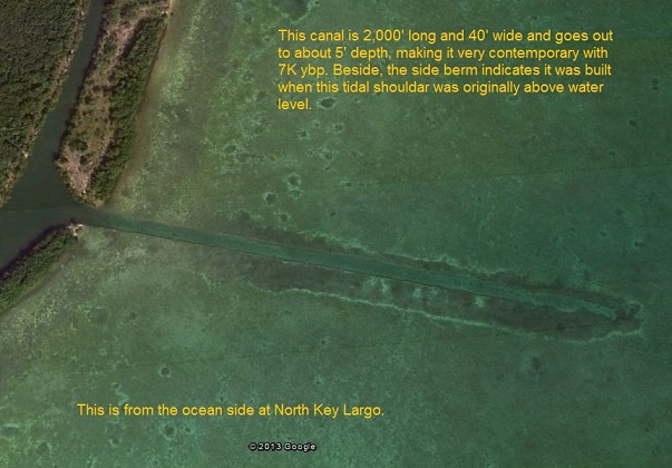
I will agree this complex does not appear to support a 5' rise in ocean level, but it certainly could and would support a 1" plus raise, putting the date of this complex somewhere between 4,500 and 5,800 years ago. In any case it is not modern, meaning it was not built in the last 100 or so years of Florida expansion. There are many other shore based complexes in the keys that show at least a three tiered tidal shoulder that is about 2' deep.
www.ancientcanalbuilders.com...
Everglades Islands Made of Prehistoric Trash Heaps
Raised just a meter or two above the water line, all of the islands are fixed in place, Chmura said. They are all oriented in the same direction. And they all have a high point in the same place. Based on those patterns, scientists have long suspected that people somehow influenced their formation.
Evidence for that theory first came in 2005, when archaeologist Margo Schwadron began excavating on some of the islands and found 42 archaeological sites that were full of human garbage. These trash mounds, or middens, contained ceramics, seeds and lots of animal bones, among other types of domestic debris.
The oldest scraps dated back more than 5,000 years, which blew away previous estimates that people first settled the Everglades just 500 to 1,000 years ago. Except for a period of yet-to-be explained abandonment between 4,400 and 2,700 years ago, the area remained populated for millennia.
"That is the new discovery, and it changes everything," Schwadron said. "All the models thought this was an uninhabitable swamp, and who would ever live there? This demonstrates that people were there from day one, and they lived there continuously for thousands of years."
It now also seems likely that the islands benefitted from their inhabitants. Fires, food waste and other refuse would have built up, forming raised areas of land for occupation by plants, animals and people. As the waste dissolved and broke down, discarded bones in particular would have helped create productive, phosphorous-rich soil.
No one can say for sure whether this process of landscape development was intentional or accidental.
news.discovery.com...
just guessing here:
seems to me that taken together with the op, these island and the canals kinda go together
i guess these islands were raised bed gardens safe out in the swamp so the enemies and the predators couldn't get at them...maybe a place to put some of the canal diggings
indian life here in my home town was related to the swamps...its where a lot of the food is
also the islands were alined the same way like they used the cross or similar to do that
the canals look like army core of engineer work they are so straight
as was pointed out earlier...before this collaborating evidence was posted ...
and they were maybe ship harbours...like why else?
edit on 9-3-2014 by Danbones because: (no reason given)
edit on 9-3-2014 by Danbones because: (no reason
given)
edit on 9-3-2014 by Danbones because: (no reason given)
bottleslingguy
reply to post by Danbones
we have to keep in mind the time frame involves limits due to the dna record. We've only been "modern humans" for no more than 200,000 years so we're limited to how fast we became smart- got wiped out- got smart-got etc. I think there have been several or many different types of hominoids throughout history but not genetically related to us. Take the Paracas coneheads for example: humanlike so much that people argue over it but the dna says they are not even part of our evolutionary history. They were smart, goal oriented, had culture etc and then just disappeared. I'd wager they didn't get physically wiped out as much as they went back to where they came from. Or maybe to a better, more stable planet where they didn't have to worry about things like tsunamis destroying everything they built. So my explanation leans toward people from other planets coming and going, not evolving out of nowhere, related to nothing on the planet and then being wiped out by a natural disaster.
There was some research done on how the diversity in genes (total number of different genes in existance on Earth) and the rate of mutation could be traced backwards to a theoretical starting points in time.
journalofcosmology.com...
The time line varies depending whether the lifeform is plant, snail (copper based lifeform) or mammal (oxygen based lifeform).
reply to post by pavil
thanks Pavil iiixillent link...
www.theguardian.com...
yep now why isn't that linked to plato's Atlantis
if i am not mistaken there are whole submerged settlements that were catching the fishermens' nets all the time in the north sea
in one of the links i posted earlier the mayan turks quote i believe the author claimed there was a link from the med to the indian ocean...prolly around the suez i guess
well this caught my eye:
journalofcosmology.com...
very interesting Stormcell
that moves the ball back a couple of [ billion ] yards
thanks Pavil iiixillent link...
A lost landscape where early humans roamed more than 12,000 years ago has been uncovered beneath the North Sea. A map of the underwater world reveals criss-crossing rivers, giant lakes and gentle hills around which hunter-gatherers made their homes and found their meals toward the end of the last ice age.
The region was inundated between 18000 and 6000BC, when the warming climate melted the thick glaciers that pressed down from the north.
www.theguardian.com...
yep now why isn't that linked to plato's Atlantis
if i am not mistaken there are whole submerged settlements that were catching the fishermens' nets all the time in the north sea
in one of the links i posted earlier the mayan turks quote i believe the author claimed there was a link from the med to the indian ocean...prolly around the suez i guess
well this caught my eye:
Genomic analysis, based on increases in genome size and the evolutionary record, indicate that genes began to evolve and to undergo duplicative events billions of years before the formation of this planet, at least 10 billion years ago. This does not mean that life began 10 billion years ago, but rather that the first gene was fashioned approximately 6 billion years before the creation of Earth. The genetic evidence supports extra-terrestrial abiognesis.
journalofcosmology.com...
very interesting Stormcell
that moves the ball back a couple of [ billion ] yards
edit on 9-3-2014 by Danbones because: (no reason given)
edit on 9-3-2014
by Danbones because: (no reason given)
reply to post by Danbones
Slayer has a great thread on the Arabian/Indian Ocean Migration of people that shows some of the landmasses that were above ocean at the time. We aren't looking for things in the right spots. We need to look at WHERE the coastlines were back in those times and then dig there.
Slayer has a great thread on the Arabian/Indian Ocean Migration of people that shows some of the landmasses that were above ocean at the time. We aren't looking for things in the right spots. We need to look at WHERE the coastlines were back in those times and then dig there.
reply to post by pavil
i agree Pavil
thats part of the premise of the ancient canal website in the op
why do you rob banks?...because thats where the money is thats why...lol
feel free to cross link if you would like
Where i am on georgian bay, off lake huron on the great lakes, the water has been dropping...since the last glaciation
I found a self sharpening stone skin scraper that was buried in silt heavy end down and vertical
maybe 200 feet up the side of the shore line...where the edge of the glacier was once
a spirit possesion or ancestor memory event the elders said..it was confirmed by an expert.
but the expert couldn't deal with the location....messed him up a little...
a self sharpening stone tool...
edit on 9-3-2014 by Danbones because: (no reason given)
Danbones
Harte
TXRabbit
Very interesting theory about ancient canals. While I explore it as certainly being possible, I still won't donate $$ to the website you linked to which shows the 2 (and only 2) pictures you've shared and expects us to believe.
Have any artifacts been recovered lending credence to these ports and canals existing?edit on 8-3-2014 by TXRabbit because: removed verbage that unintentionally sounded harsh
Canals courtesy of Army Corp of Engineers. They are dredged regularly because they fill in naturally.
"Harbors" also the result of modern dredging.
Good idea, not donating money to a fraud.
Harte
so you got any proof Harte?
remember the "other poster" you referenced on bts's thread re the hyogeum?
that was a lol, didn't work out so good for you there eh?
hope you can do better then that referencing this time
lol
never heard of the harbour at alexandria Harte?
In fact, I proved my point completely in that thread. Not surprising, though, that you couldn't understand it.
So, first, give us the "proof" that canals, which fill in naturally in a decade or so, can somehow last undredged for thousands of years.
My advice to you, ask your own self the elementary questions like that one before you swallow a cock-and-bull story from a fringe source.
Danbones
Could the undeniably geometric ruins in India’s Gulf of Cambay be the lost city of Lord Krishna? Many Indians believe so, designating Dwarka as an important site for Hindu pilgrimage. The ruins are located just off the coast of modern-day Dwarka, one of the seven oldest cities in India. The ancient Dwarka was a planned city built on the banks of the Gomati river but was eventually deserted and submerged into the sea, as documented in texts like the Mahabharata and Purana, though some experts maintain that it was mythological.
As the story goes, Lord Krishna had a beautiful and prosperous city built, with 70,000 palaces made of gold, silver and other precious metals. It was his death that supposedly sent Dwarka sinking into the sea.
The ruins, discovered in 2000 and investigated with acoustic techniques, are known as the Gulf of Khambat Cultural Complex. They’re 131 feet beneath the surface. One of the artifacts dredged up by scientists was dated around 7500 BCE, which could support the theories that it is, in fact, the ancient Dwarka.
from the above link
Unfortunately for you, you simply have eaten another sheet sandwich some idiot handed you.
See, the archaeological site off the coast of modern Dawarka (at the mouth of the Gulf of Kutch) is not even in the Gulf of Cambay (Khambat.)
Info on the bogus Gulf of Cambay site (note map on page one):
link
Info on the legitimate Dawarka site (PDF download) note map on page 2:
Link2
Your source is confusing a legitimate archaeological site that sank a couple of centuries ago due to tectonic movements and erosion with a bogus site where Graham Hancock dredged the ocean floor and found some hardened tubeworm tubes and an old piece of wood.
Harte
bottleslingguy
reply to post by Danbones
Harte has no idea what he's talking about concerning these things. The size of the area containing these structures is so large any attempt at that scale would be the biggest undertaking ever imagined. They are found in areas where the Army Corps hasn't bothered to even think about going and for no good reason anyway. Some people act like authorities on this subject, but they've not spent one minute studying them and deep down inside they know they've waisted their lives studying the wrong things. I think there are going to be a lot of bitter archaeologists just around the corner, so we have to prepare for the angry responses.
Oh, yes, magically self-dredging permanent canals.
Harte
reply to post by Danbones
thats a photo of one the dredged ww2 wharfs in the area. most of the nearby hardware is gone eg us army test radar stations, amphibious vehicle training sites mostly all now rotted away and later on the sites nike-ajax rockets and supporting installations.
thats a photo of one the dredged ww2 wharfs in the area. most of the nearby hardware is gone eg us army test radar stations, amphibious vehicle training sites mostly all now rotted away and later on the sites nike-ajax rockets and supporting installations.
Danbones
here is a chinese map not so early maybe...but early enough to make one wonder
i don't know enough about projection to verify this map or if it came from an older one,
but there is much to be said for early Chinese in north america
funny though that columbus was right after marko polo

Nah.
Thankfully, as Shanghaist points out, there are actual historians on the case, namely Geoff Wade.
It is a dual-hemisphere map, a cartographic tradition exclusively European. California is represented as an island, copied straight from European maps of the 17th century. China is placed at the centre of the map as it was in early Jesuit maps of the world produced in China. It is based on a rough copy of a Jesuit map of the world.
The eunuch Zheng He is referred to as Ma San-bao. No one would have dared to use his original name given that the emperor had assigned him the surname Zheng.
The amount of non-coastal detail (including riverine systems extending thousands of miles from the coast) indicate that these maps could not have been produced by maritime voyagers. The information in the maps was obviously amassed over time by cultures who had travelled widely. It fits perfectly within the history of European cartography, but is a complete anomaly in Chinese cartography.
The Himalayas are marked as the highest mountains in the world. This fact was only discovered in the 19th century.
Source
Harte
reply to post by Harte
right off the top my av proves you wrong Harte just by existing
the pyramid shaft robot film does that
and no, as a pro sound tech...no you didn't prove me wrong sadly the charts and graphs did you in there
and
finally...note the florida island post up the page
right off the top my av proves you wrong Harte just by existing
the pyramid shaft robot film does that
and no, as a pro sound tech...no you didn't prove me wrong sadly the charts and graphs did you in there
and
finally...note the florida island post up the page
here is a chinese map not so early maybe...but early enough to make one wonder
i don't know enough about projection to verify this map or if it came from an older one,
but there is much to be said for early Chinese in north america
funny though that columbus was right after marko polo
well Harte thank you for that
i said it was questionable in my comment
you may have just proved me correct on that one
thanks pal
oh,
are you trying to say i was incorrect: columbus discovered america before marco polo went to china?
edit on 9-3-2014 by Danbones because: (no
reason given)
suicideeddie
reply to post by Danbones
thats a photo of one the dredged ww2 wharfs in the area. most of the nearby hardware is gone eg us army test radar stations, amphibious vehicle training sites mostly all now rotted away and later on the sites nike-ajax rockets and supporting installations.
while we are on the subject of proof...
link please
Danbones
reply to post by Harte
right off the top my av proves you wrong Harte just by existing
the pyramid shaft robot film does that
and no, as a pro sound tech...no you didn't prove me wrong sadly the charts and graphs did you in there
and
finally...note the florida island post up the page
Dredged out canals. Used to live in the Keys myself.
Sorry. You claimed limestone had some "unique" property regarding reflection of sound. I proved it did not.
Again, not surprised that you can't understand it, or accept it.
Harte
even if thier age is 75 years they still look well preserved how long do think it will take them to fall apart?
Harte
bottleslingguy
reply to post by Danbones
Harte has no idea what he's talking about concerning these things. The size of the area containing these structures is so large any attempt at that scale would be the biggest undertaking ever imagined. They are found in areas where the Army Corps hasn't bothered to even think about going and for no good reason anyway. Some people act like authorities on this subject, but they've not spent one minute studying them and deep down inside they know they've waisted their lives studying the wrong things. I think there are going to be a lot of bitter archaeologists just around the corner, so we have to prepare for the angry responses.
Oh, yes, magically self-dredging permanent canals.
Harte
you have to back your self up Harte just like you expect everyone else to do
new topics
-
Sunak spinning the sickness figures
Other Current Events: 19 minutes ago -
Nearly 70% Of Americans Want Talks To End War In Ukraine
Political Issues: 30 minutes ago -
Late Night with the Devil - a really good unusual modern horror film.
Movies: 2 hours ago -
Cats Used as Live Bait to Train Ferocious Pitbulls in Illegal NYC Dogfighting
Social Issues and Civil Unrest: 3 hours ago -
The Good News According to Jesus - Episode 1
Religion, Faith, And Theology: 5 hours ago -
HORRIBLE !! Russian Soldier Drinking Own Urine To Survive In Battle
World War Three: 7 hours ago -
Bobiverse
Fantasy & Science Fiction: 10 hours ago -
Florida man's trip overseas ends in shock over $143,000 T-Mobile phone bill
Social Issues and Civil Unrest: 10 hours ago
top topics
-
Florida man's trip overseas ends in shock over $143,000 T-Mobile phone bill
Social Issues and Civil Unrest: 10 hours ago, 8 flags -
SETI chief says US has no evidence for alien technology. 'And we never have'
Aliens and UFOs: 14 hours ago, 7 flags -
Cats Used as Live Bait to Train Ferocious Pitbulls in Illegal NYC Dogfighting
Social Issues and Civil Unrest: 3 hours ago, 7 flags -
This is our Story
General Entertainment: 17 hours ago, 4 flags -
Former Labour minister Frank Field dies aged 81
People: 12 hours ago, 4 flags -
Bobiverse
Fantasy & Science Fiction: 10 hours ago, 3 flags -
Late Night with the Devil - a really good unusual modern horror film.
Movies: 2 hours ago, 2 flags -
HORRIBLE !! Russian Soldier Drinking Own Urine To Survive In Battle
World War Three: 7 hours ago, 2 flags -
The Good News According to Jesus - Episode 1
Religion, Faith, And Theology: 5 hours ago, 0 flags -
Nearly 70% Of Americans Want Talks To End War In Ukraine
Political Issues: 30 minutes ago, 0 flags
active topics
-
Remember These Attacks When President Trump 2.0 Retribution-Justice Commences.
2024 Elections • 55 • : Zanti Misfit -
SETI chief says US has no evidence for alien technology. 'And we never have'
Aliens and UFOs • 36 • : anthelion -
President BIDEN Vows to Make Americans Pay More Federal Taxes in 2025 - Political Suicide.
2024 Elections • 110 • : underpass61 -
Breaking Baltimore, ship brings down bridge, mass casualties
Other Current Events • 481 • : firerescue -
Truth Social goes public, be careful not to lose your money
Mainstream News • 124 • : lilzazz -
British TV Presenter Refuses To Use Guest's Preferred Pronouns
Education and Media • 145 • : Annee -
Nearly 70% Of Americans Want Talks To End War In Ukraine
Political Issues • 2 • : Consvoli -
Sunak spinning the sickness figures
Other Current Events • 0 • : annonentity -
Cats Used as Live Bait to Train Ferocious Pitbulls in Illegal NYC Dogfighting
Social Issues and Civil Unrest • 9 • : ImagoDei -
Late Night with the Devil - a really good unusual modern horror film.
Movies • 3 • : Hecate666