It looks like you're using an Ad Blocker.
Please white-list or disable AboveTopSecret.com in your ad-blocking tool.
Thank you.
Some features of ATS will be disabled while you continue to use an ad-blocker.

Beijing-bound MAS plane carrying 239 people missing as of 20 mins ago.
page: 231share:
reply to post by UnBreakable
I and others after posted this same picture long ago through this thread. Funny people are actually looking at it more now because she has posted it. If you look closely though you will recognize it from before. It was written off then and now its turned into a joke.
I myself still think that picture didnt really get the credit it deserved in its original post. This is the one the Dutch freighter was suppose to go look at. People tracking the freighter said it never really went to the coordinates. Just sailed on by.
whatnext21
reply to post by civpop
I just found a feature on the Tomrad where you can download results up in the top right corner, it then takes you to google earth and plots all the findings thus far.
If you zoom in on an area, clicking on one of the markers brings up a picture of the tile of interest, its number, etc.
Thanks that's cool ill take a look
WanDash
DrHammondStoat
Not good if true;
...It would support the Westward turn and then Thailand saying it wasn't detected by it's Northern radar.
Pardon me for being dense this morning, good Dr'...but, what do you mean by 'not good if true'?
Thanks!
Morning WanDash, I mean if it went that way there is nothing but sea and it likely ran out of fuel there. Very sad but that's what I think happened tbh.
reply to post by CCKP72
I agree! Maybe they came up with the evidence, which is why it took a week to come out!
I agree! Maybe they came up with the evidence, which is why it took a week to come out!
UnBreakable
civpop
Stop press Courtney love has found it.
Sorry just wanted to lighten it a little
Wouldn't that be hilarious if that is it? Not hilarious in the fact the plane crashed but imagine the headlines if Courtney Love upstages sophisticated equipment from all the nations tech?edit on 18-3-2014 by UnBreakable because: (no reason given)
Except someone here on ATS found this a while ago......unless she's here on ATS?.. Hi Courtney!
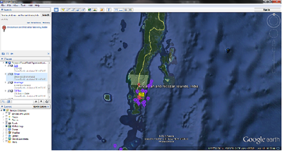
Could someone tell me what this is just on the coast of iran on google maps. doesnt look like ships i think. Maybe someone knows what they are
onehuman
reply to post by UnBreakable
I and others after posted this same picture long ago through this thread. Funny people are actually looking at it more now because she has posted it. If you look closely though you will recognize it from before. It was written off then and now its turned into a joke.
I myself still think that picture didnt really get the credit it deserved in its original post. This is the one the Dutch freighter was suppose to go look at. People tracking the freighter said it never really went to the coordinates. Just sailed on by.
I didn't read all 230 pages on here. I didn't realize that this pic was posted previously. Good find. Courtney was obviously a day late and a dollar short. I wonder why the freighter didn't take a look. Maybe it was told by someone to just ignore it. Maybe someone doesn't want it to be found............yet. Maybe it was carrying something that we shouldn't be made aware of.
reply to post by onehuman
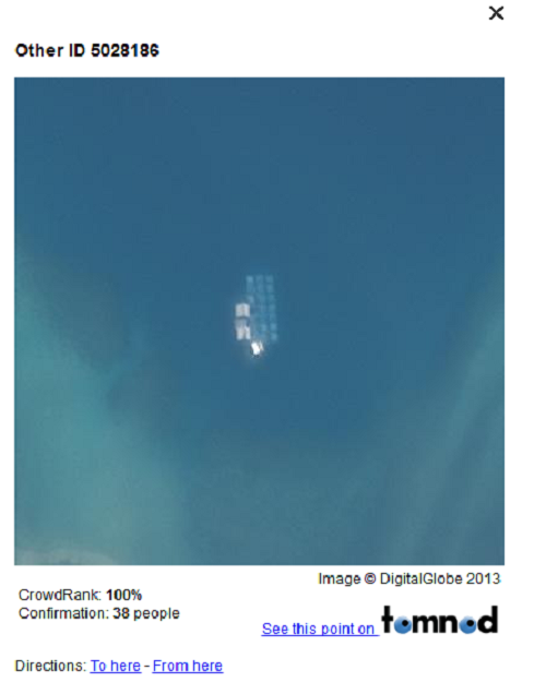
Digital Graphics did some enhancement work on the picture and they are saying its a boat, the picture is here
Twitter Digital Graphics
Digital Graphics did some enhancement work on the picture and they are saying its a boat, the picture is here
Twitter Digital Graphics
DrHammondStoat
Morning WanDash, I mean if it went that way there is nothing but sea and it likely ran out of fuel there. Very sad but that's what I think happened tbh.
Gotcha!
Well - I suppose I'm a little more (perhaps Too) optimistic...and, I was hoping that, since the plane was flying so low...it might have actually landed further to the south of the spotting (and thus, hopefully, all of the innocents might have been spared).
Also for clarification, the picture of the plane someone also posted from tomnod is apparently in flight and not MH370 according to their twitter.
Tomnod Twitter
Tomnod Twitter
reply to post by onehuman
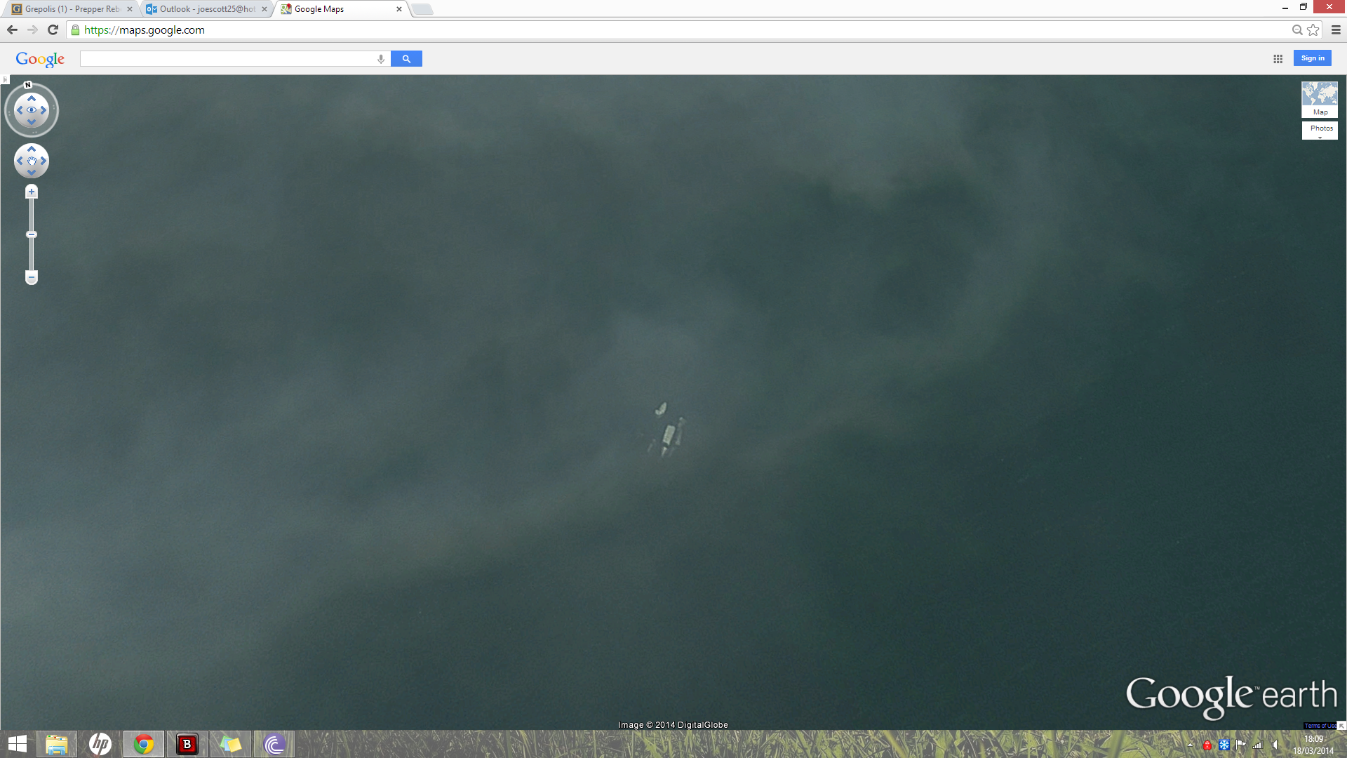
I was on here when you posted it. It really looks like a plane laying on it's side and you can make out windows too.
I was on here when you posted it. It really looks like a plane laying on it's side and you can make out windows too.
reply to post by Myrtales Instinct
Yes I think so as well. From the post above you, the picture they used to discredit it just doesnt strike me as the same picture either. Not to mention what about all the other stuff in the picture that looks like debris and a oil slick. Why didnt they show that too?
Yes I think so as well. From the post above you, the picture they used to discredit it just doesnt strike me as the same picture either. Not to mention what about all the other stuff in the picture that looks like debris and a oil slick. Why didnt they show that too?
Does anyone have a credible source for the claim that disabling ACARS after takeoff is standard operating procedure for Malaysian Airlines flights?
This I think is extremely important in judging whether it was an accident or a hijacking.
I can't find any news articles that discuss this. Maybe my Google skills are inadequate.
This I think is extremely important in judging whether it was an accident or a hijacking.
I can't find any news articles that discuss this. Maybe my Google skills are inadequate.
liteonit6969
Looking at possible landing sites in indian ocean and the simulators for landing in some areas in indian ocean i thought id have a look. I came across this in the Seychelles. It looks like a 777-200 to me. This may be a popular route for this plane but just thought id add it in. You can even see the maintenance so its just landed or ready for take off. any thoughts?
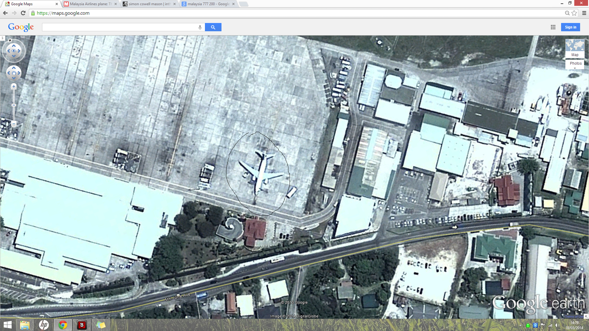
I think that's a Boeing 737. Are you using Google Maps? Use Google Earth, It has a measuring tool. A 777-200 has a 199' wingspan and a fuselage 209' long.
Am I right in think g google earth doesn't have updated satellite imagery ?
Can you get latest satellite imagery for it though ?
Can you get latest satellite imagery for it though ?

Last time I used Google Earth, there was a time slider where I could look at various images over time, but none of them were very recent. The tomnod images are recent, that's why you see people talking about and posting images from tomnod.
rabourby
Am I right in think g google earth doesn't have updated satellite imagery ?
Can you get latest satellite imagery for it though ?
edit on 18-3-2014 by Arbitrageur because: clarification
From pprune quite a good timeline I think although it's better viewed on the pp rune site
Link pprune
(*or at least have a separate "unidentified official" verification on from a reputable source) - 1:07 - ACARS last transmission (thru VHF) which apparently includes notation of a WP change having been entered into system since last scheduled report at 12:37 - 1:11 - INMARSAT ping would have been received, as apparently Boeing's AHM report attempted to automatically transmit (thru Satellite) - 1:19 - 'Alright, Good Night' at handover (supposedly by co-pilot) - 1:22 - Transmitter goes off (note: those previous two might be reversed, we have multiple sources seemingly confirming both possibilities. One happened at 1:19, one at 1:22 though. I'm putting them in this order mainly because...) - 1:22 - Plane goes out of range/black from Thailand Radar (likely from the transponder going black and not the plane going out of range) - 1:28 - Unidentified plane shows up on Thailand Radar roughly off the Kota Bharu, Malaysia coast (at Malaysia/Thailand border) and this apparently shows plane crossing the Peninsula to the Straights of Malacca (unknown endtime for this path) - somewhere between 1:15-1:30 - Vietnam sees plane turn around. From roughly 1:30-forward, Vietnam is "frantically" trying to contact the plane (note: they have not told us a specific time of turn or if they know this because of a Military or ATC radar hit, but they told Malaysia they 'watched plane turn around' sometime shortly after contact was lost) - 1:37 - ACARS misses scheduled transmission - 1:30-1:45 - at minimum 11 eye witness reports from around and past the Kota Bharu, Malaysia/Thailand border areas (including one saying 'plane descending fast' like one of the later radar hits indicates) - 2:11 - INMARSAT ping would have been received, as apparently Boeing's AHM report attempted to automatically transmit (thru Satellite) - between 1:30-2:40 - Malaysian Military and Civilian radar picks up an "unidentified" plane flying over peninsula (Daud says "this was corroborated by civilian radar" in the march 9th press conferences). Those include a couple radar hits we have specifically been told about* (and who knows how many that haven't been provided/leaked): ... VAMPI ... GIVAL ... IGREX (note: we are not sure of the timing of the radar hits, and there is very contradictory evidence here. The most recent seemingly-official time is 2:15 for the last hit. Which hit that was, we don't know for sure) post 2:15/or/2:40 apparent absolute complete blackout of plane (except...) - 3:11 - INMARSAT ping received, as apparently Boeing's AHM report attempted to automatically transmit (thru Satellite) - 4:11 - INMARSAT ping received, as apparently Boeing's AHM report attempted to automatically transmit (thru Satellite) - 5:11 - INMARSAT ping received, as apparently Boeing's AHM report attempted to automatically transmit (thru Satellite) - 6:11 - INMARSAT ping received, as apparently Boeing's AHM report attempted to automatically transmit (thru Satellite) - 7:11 - INMARSAT ping received, as apparently Boeing's AHM report attempted to automatically transmit (thru Satellite) near 40 Degree line - 7:24 - Statement released by Malaysian Officials saying contact lost at 2:40 and SAR efforts are underway - 8:11 - INMARSAT ping received, as apparently Boeing's AHM report attempted to automatically transmit (thru Satellite) (thru Satellite) on 40 Degree line
Link pprune
edit on 18-3-2014 by civpop because: (no reason given)
new topics
-
Any one suspicious of fever promotions events, major investor Goldman Sachs card only.
The Gray Area: 1 hours ago -
God's Righteousness is Greater than Our Wrath
Religion, Faith, And Theology: 5 hours ago -
Electrical tricks for saving money
Education and Media: 9 hours ago -
VP's Secret Service agent brawls with other agents at Andrews
Mainstream News: 10 hours ago -
Sunak spinning the sickness figures
Other Current Events: 11 hours ago -
Nearly 70% Of Americans Want Talks To End War In Ukraine
Political Issues: 11 hours ago
top topics
-
VP's Secret Service agent brawls with other agents at Andrews
Mainstream News: 10 hours ago, 9 flags -
Cats Used as Live Bait to Train Ferocious Pitbulls in Illegal NYC Dogfighting
Social Issues and Civil Unrest: 14 hours ago, 8 flags -
Electrical tricks for saving money
Education and Media: 9 hours ago, 4 flags -
Nearly 70% Of Americans Want Talks To End War In Ukraine
Political Issues: 11 hours ago, 3 flags -
Sunak spinning the sickness figures
Other Current Events: 11 hours ago, 3 flags -
Late Night with the Devil - a really good unusual modern horror film.
Movies: 13 hours ago, 2 flags -
Any one suspicious of fever promotions events, major investor Goldman Sachs card only.
The Gray Area: 1 hours ago, 2 flags -
The Good News According to Jesus - Episode 1
Religion, Faith, And Theology: 16 hours ago, 1 flags -
God's Righteousness is Greater than Our Wrath
Religion, Faith, And Theology: 5 hours ago, 0 flags
active topics
-
God's Righteousness is Greater than Our Wrath
Religion, Faith, And Theology • 11 • : andy06shake -
SETI chief says US has no evidence for alien technology. 'And we never have'
Aliens and UFOs • 60 • : Scratchpost -
Election Year 2024 - Interesting Election-Related Tidbits as They Happen.
2024 Elections • 73 • : Threadbarer -
Sunak spinning the sickness figures
Other Current Events • 8 • : McUrnsalso -
-@TH3WH17ERABB17- -Q- ---TIME TO SHOW THE WORLD--- -Part- --44--
Dissecting Disinformation • 661 • : Justoneman -
HORRIBLE !! Russian Soldier Drinking Own Urine To Survive In Battle
World War Three • 36 • : TheMisguidedAngel -
British TV Presenter Refuses To Use Guest's Preferred Pronouns
Education and Media • 146 • : Consvoli -
Nearly 70% Of Americans Want Talks To End War In Ukraine
Political Issues • 19 • : Consvoli -
Terrifying Encounters With The Black Eyed Kids
Paranormal Studies • 76 • : Consvoli -
Samuel Aun Woer
Religion, Faith, And Theology • 27 • : helebi20