It looks like you're using an Ad Blocker.
Please white-list or disable AboveTopSecret.com in your ad-blocking tool.
Thank you.
Some features of ATS will be disabled while you continue to use an ad-blocker.

North Atlantic Hurricane Watch 2014-2016
page: 2share:
a reply to: jadedANDcynical
By region? No not at present but I can. When I next look at that I will see.
Yes the gist was that what is reported as10 days of Cat Force 2 may only have one or two days in that time which is actually at Force 2.
By region? No not at present but I can. When I next look at that I will see.
Yes the gist was that what is reported as10 days of Cat Force 2 may only have one or two days in that time which is actually at Force 2.
Just one of the several hurricanes in the Atlantic that we catch the edge of that never get reported as hurricanes
Click the image to enlarge
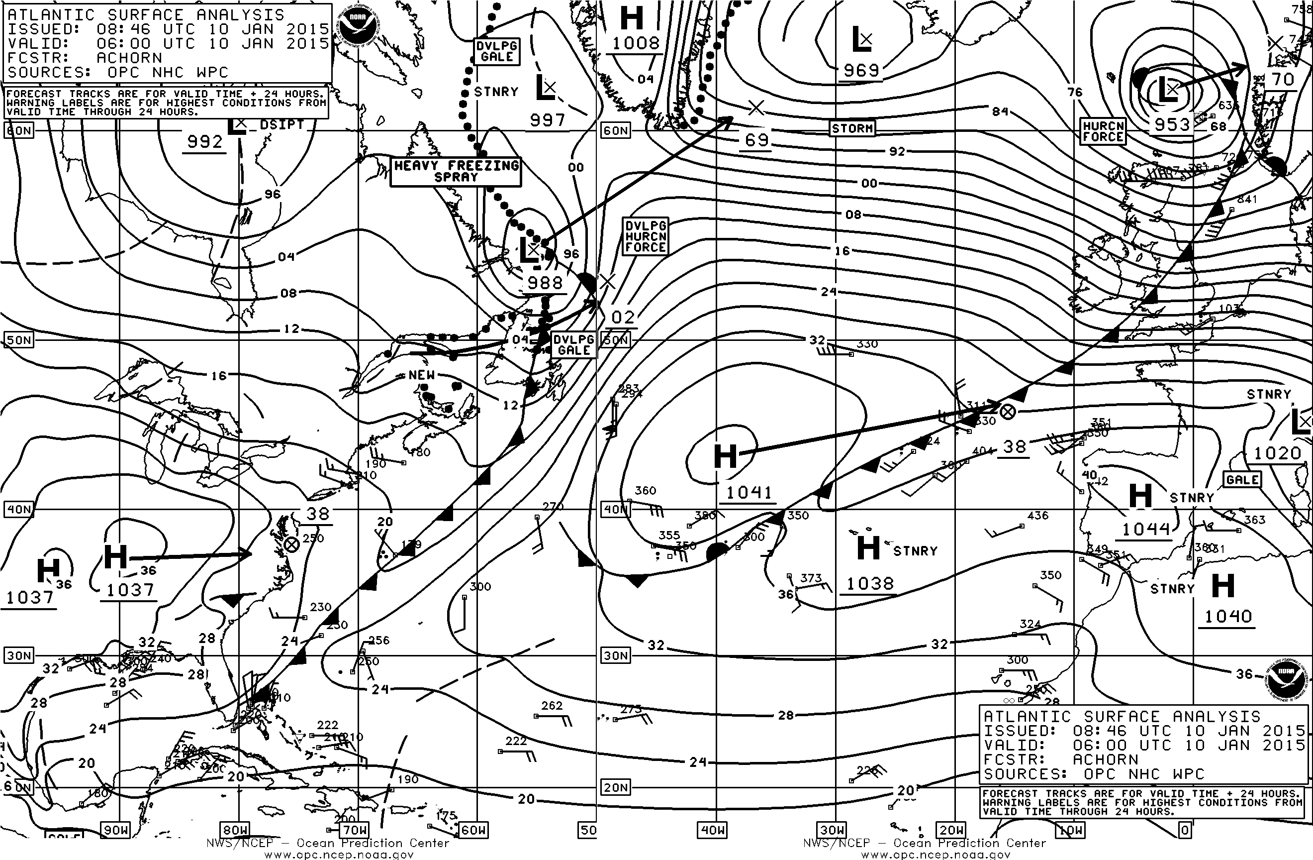
Major wind last night, trees down, power out for several hours until around 11 am this morning. Bit of a stiff breeze really with gusts in excess of 120km/hr in the north of Ireland.

Click the image to enlarge
Major wind last night, trees down, power out for several hours until around 11 am this morning. Bit of a stiff breeze really with gusts in excess of 120km/hr in the north of Ireland.
edit on 10/1/2015 by PuterMan because: (no reason given)
It's not called a hurricane because it's not a hurricane. Hurricanes by their very nature are tropical in origin and in order to be called a
hurricane they need to develope in the tropics. Water temps need to be above 80° for developement. By the time these storms reach Europe they are
extratropical which means they no longer have potential for increased developement and are no longer considered a tropical system. I don't have a way
of knowing what the origin of the storm you experienced was but the Atlantic tropical season ends in November. We had a minor storm develope in early
Dec a year or two ago but in my time of keeping track which goes back a few decades I only know of that one. Pressure gradients with a large
difference in air pressure readings in converging fronts can cause very strong winds. The jet stream dipped very low over the state's this past week
bringing extremely high air pressure to the Midwest. Lower pressure over the western Atlantic stalled out in front of this high pressure and brought
high winds to the eastern seaboard the last few days. A similar situation may have set up over the north Atlantic bringing high winds to the British
isles as well. Do you know how to read a weather chart? If so you know that the tighter those circle areas are(called isobars) the stronger the wind.
I think you probably know this because of your interest in this subject. By the image you included it looks like an isolated low over your area. The
Atlantic behind that system looks calm and further west and south there's a high pressure system which at this time of year brings cold cold temps to
the mid Atlantic. So I don't think this was a wayward hurricane I think it was a very low pressure system crashing into a high pressure system.
A reply to: PuterMan
A reply to: PuterMan
edit on 1102015 by AutumnWitch657 because: (no reason given)
a reply to: AutumnWitch657
Whilst the term 'hurricane' may be what is applied to only to tropical storms nowadays, and yes the bulk of the Northern Atlantic storms that affect us in Ireland and the UK are indeed extratropical and a cold core system, temperature is of course involved.
In terms of the Beaufort wind force scale they are hurricanes by definition of being in excess of 64 knots sustained wind speed. I am not even sure if the definition tropical cyclone was around when Beaufort devised his scale. They were hurricanes when I was at school 60 years ago, if they were out in the Atlantic, and they still are as described by the World Meteorological Organization in conjunction with the Beaufort scale.
Semantics of course but even NOAA still uses the same terminology in connection with the Beaufort scale. A storm achieving sustained wind speeds in excess of 64 knots IS a hurricane as Michael Fish is probably aware!
Actually I can see no logic in not naming them but for the fact that they are relatively short lived, but then so are the tropical storms in many cases. I do of course realise that the modern terminology has changed the original in common usage but that does not make the original wrong. Modern does not mean better since if that were the case all ambiguity would be removed by calling all storms cyclones and having a graduation to suit.
Whether the origin of the storm is tropical or baroclinical these are still hurricane force storms where hurricane refers to the force of the winds and not necessarily the type of system. In modern parlance hurricane force would be more correct or actually as I prefer a category force storm regardless of its nomenclature. This is described by the Saffir-Simpson Hurricane force scale (there is that hurricane word again) which whilst officially only applicable to tropical origin storms adequately covers a division of the 'hurricane' force of the Beaufort scale.
I don't know about the eastern seaboard but stalled they were not, and in fact it was the high pressure that was stalled. The lows have been developing over Canada and south of Greenland, and off the coast of Newfoundland and skating across the Atlantic bouncing off the stalled high (complex system of high pressure actually) to the south.
www.youtube.com...
Yes.
It's not called a hurricane because it's not a hurricane. Hurricanes by their very nature are tropical in origin and in order to be called a hurricane they need to develope in the tropics.
Whilst the term 'hurricane' may be what is applied to only to tropical storms nowadays, and yes the bulk of the Northern Atlantic storms that affect us in Ireland and the UK are indeed extratropical and a cold core system, temperature is of course involved.
In terms of the Beaufort wind force scale they are hurricanes by definition of being in excess of 64 knots sustained wind speed. I am not even sure if the definition tropical cyclone was around when Beaufort devised his scale. They were hurricanes when I was at school 60 years ago, if they were out in the Atlantic, and they still are as described by the World Meteorological Organization in conjunction with the Beaufort scale.
Semantics of course but even NOAA still uses the same terminology in connection with the Beaufort scale. A storm achieving sustained wind speeds in excess of 64 knots IS a hurricane as Michael Fish is probably aware!
Actually I can see no logic in not naming them but for the fact that they are relatively short lived, but then so are the tropical storms in many cases. I do of course realise that the modern terminology has changed the original in common usage but that does not make the original wrong. Modern does not mean better since if that were the case all ambiguity would be removed by calling all storms cyclones and having a graduation to suit.
Whether the origin of the storm is tropical or baroclinical these are still hurricane force storms where hurricane refers to the force of the winds and not necessarily the type of system. In modern parlance hurricane force would be more correct or actually as I prefer a category force storm regardless of its nomenclature. This is described by the Saffir-Simpson Hurricane force scale (there is that hurricane word again) which whilst officially only applicable to tropical origin storms adequately covers a division of the 'hurricane' force of the Beaufort scale.
Lower pressure over the western Atlantic stalled out in front of this high pressure and brought high winds to the eastern seaboard the last few days.
I don't know about the eastern seaboard but stalled they were not, and in fact it was the high pressure that was stalled. The lows have been developing over Canada and south of Greenland, and off the coast of Newfoundland and skating across the Atlantic bouncing off the stalled high (complex system of high pressure actually) to the south.
www.youtube.com...
Do you know how to read a weather chart?
Yes.
edit on 12/1/2015 by PuterMan because: Thought I had a tag problem but my browser had gone wonky
Thank you. Yes we can get hurricane force winds at any time during the year. We had a noreaster last winter or perhaps the winter before, that caused
a lot of damage due to high winds.
You are right it was the super high that stalled. Brought very cold temps even into the south where winter is usually milder. I live in coastal Virginia . Hurricanes I know. Winter storms not so much. I left them behind when I moved here from up north on Long Island.
So you live in Ireland?
I always thought you were here in the states for some reason. California or at least west coast perhaps Washington state. I don't know why.
a reply to: PuterMan
edit on 1122015 by AutumnWitch657 because: (no reason given)
a reply to: AutumnWitch657
A bit of a stiff breeze today. It has picked up a pile of 16' four by fours in the garden and scattered them!
Source: ESB Updates
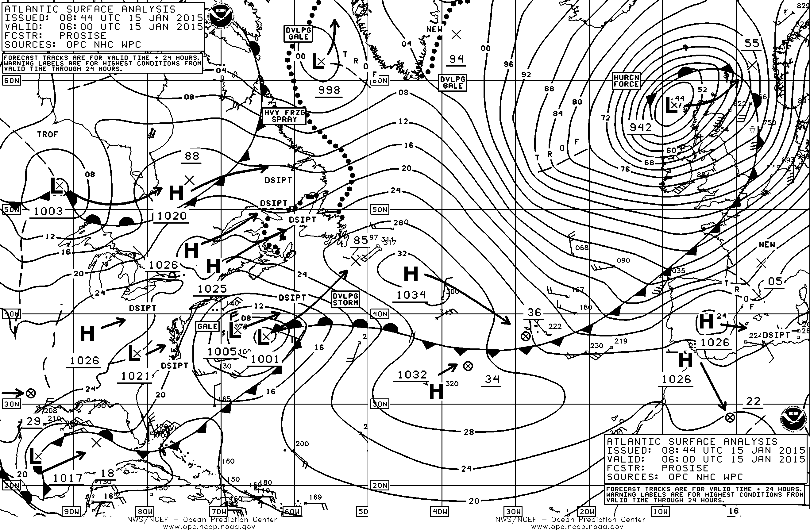
Click the image to enlarge
Gusting to 150 km/hr (just 4 km/hr under force 2)
I live right under the line of the 68 isobar about 20 miles in as the crow files. We have a Red warning for wind today. Gives the school children an automatic day at home!!
PS West Of Ireland may include the US but it actually is the West of Ireland
A bit of a stiff breeze today. It has picked up a pile of 16' four by fours in the garden and scattered them!
Overnight strong and gale force winds with gusts of up to 150km/h have caused damage to electricity infrastructure in the North West, West and South of the country. At present, ESB Networks estimate that 15,000 customers are without power in the following areas – Donegal, Cork, Killarney, Galway/Athlone, Tullow and Wexford. We are continuously monitoring the situation and updates will be issued during the day.
Source: ESB Updates

Click the image to enlarge
Gusting to 150 km/hr (just 4 km/hr under force 2)
I live right under the line of the 68 isobar about 20 miles in as the crow files. We have a Red warning for wind today. Gives the school children an automatic day at home!!
PS West Of Ireland may include the US but it actually is the West of Ireland
edit on 15/1/2015 by PuterMan because: To add PS
edit on 15/1/2015 by PuterMan because: (no reason given)
a reply to: PuterMan
My father in law once had a metal garden shed picked up and set down on the other side of a fence in his neighbors yard! That was Hurrican Gloria back in the eighties. There were many wonders to see all around long island from that one. I saw two hundred year old oak trees snapped off at street level.
Mother nature shows no favorites. We're all going to feel her wrath at some point or another.
Except maybe in Shangri la.
a reply to: PuterMan
Your map is a little too small for my old eyes sorry. I can see the tight isobars though. LOL
Is there a rotation? Is it squally?. 942 on the barometer is it steady or falling? And what are the temps? Your in for a bluster in any event.
I'm no expert like you. I'm just an outdoor kind of girl that learned a thing or two by watching the sky. I actually do better with water vapor imagery.
East of the United states may include Great Britian but I'm in the east of the United states lol.
edit on 1162015 by AutumnWitch657 because:
(no reason given)
a reply to: AutumnWitch657
Better late than never to reply. Yes my old eyes have problems as well but if you click on the map it will open in a larger version, which if you click will get even larger. Large enough for our old eyes!!
Squally yes, rotating yes but not fast. At that point in time it was beginning to fill and by 2100 analysis was at 953 on the barometer.
This was the Surface winds analysis at the time
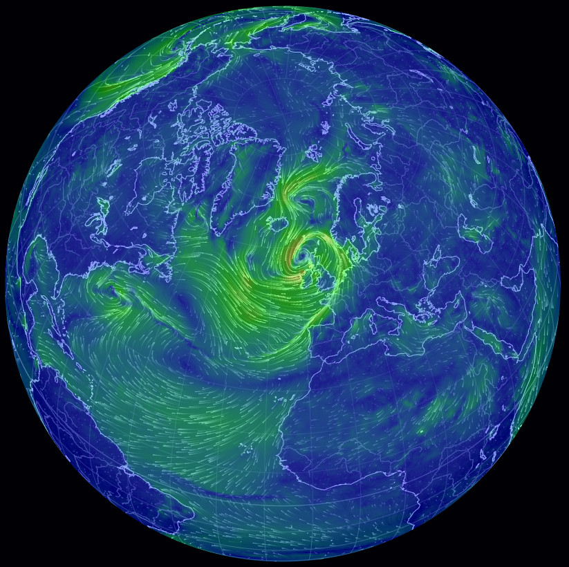
Click the image to enlarge
You may find the site from which that came of interest. Spin the globe with your mouse to get the view you want. Click on 'Earth' to get the settings menu.
edit on 12/4/2015 by PuterMan because: speeling eras
a reply to: PuterMan
Lol yes better late than never. Now we're planting seedlings to fill in this summer's garden. It was 84° two days ago. That's Fahrenheit. Your map may come in handy if there's a tropical headed this way this summer. We usually don't even need to start looking until Aug here in the mid Atlantic. Then the cape verde storms start kicking up their heels. There seems to be cycles where there is more activity and cycles where there is less.
The 90s were an active period but since Isabel things have quoted down for the east coast. I think we won't enter another active cycle until the 2020s. Every thirty years or so. .
a reply to: AutumnWitch657
Mid Atlantic or Sahara. Here today we have snow on Nephin, our local mountain. It is not very high (2600 ft) and this is the first time in the 13 years I have lived here that I have seen it snowcapped at this time of year.
No seedlings for us. Our current temperature (mid afternoon) is the reverse of yours at 48°F
Now we're planting seedlings to fill in this summer's garden. It was 84° two days ago. That's Fahrenheit
Mid Atlantic or Sahara. Here today we have snow on Nephin, our local mountain. It is not very high (2600 ft) and this is the first time in the 13 years I have lived here that I have seen it snowcapped at this time of year.
No seedlings for us. Our current temperature (mid afternoon) is the reverse of yours at 48°F
a reply to: PuterMan
No wonder you English are so passionate about your gardens. You get so little time to actually grow them.
I have flowers all year long. In the fall we plant panders for winter and early spring color.
Camelias are in full bloom now. I have three specimens of japoonica. Red pink and white.
Azaleas wi start in another week or so. But I can't grow some plants because they can't take the heat and humidity of summer. Lilacs and delpheniums are two I would love to grow. Crepe mertel are prized here and won't grow further north of us.
A new tropical depression is in the Gulf of Mexico and it's aimed right at the Texas coast:
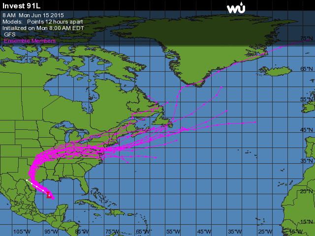
Invest 91L
For anyone who doesn't know, we've already had torrential rains here in the state, and all of this tropical moisture won't have much place to go insofar as being soaked into the ground.
Expect a lot more flooding in the next few days.
Invest 91L
For anyone who doesn't know, we've already had torrential rains here in the state, and all of this tropical moisture won't have much place to go insofar as being soaked into the ground.
Expect a lot more flooding in the next few days.
a reply to: jadedANDcynical
Hoping there are no strong winds along with the rain.
Hurricane Isabel hit the mid Atlantic after a very very wet spring and early summer. Though only a cat 2 at landfall the saturated ground could not hold the trees in place. Hundreds of thousands of trees went down on houses and powerlines from North Carolina to Deleware. The power was out in three states. Virginia, my home was hardest hit.
I saw the swirl of the milky way the night the storm ended and I live in the city where light pollution cancels out all but the brightest stars at night.
It took months to get the roads cleared and all the power lines repaired.
If you hike into any forest in Virginia today you can still see the damage from that storm.
So keeping my fingers crossed for you guys. No floods no wind damage.
a reply to: AutumnWitch657
It's looking like a rain producer, which could do more damage than winds. I saw on a forum I'm on that a rare Scenario could occur where the storm takes a lot longer to dissipate or even become stronger over land ( It would no longer be tropical when it moves far enough inland but can still hold tropical storm force winds) due to the amounts of moisture in the soil.
It's looking like a rain producer, which could do more damage than winds. I saw on a forum I'm on that a rare Scenario could occur where the storm takes a lot longer to dissipate or even become stronger over land ( It would no longer be tropical when it moves far enough inland but can still hold tropical storm force winds) due to the amounts of moisture in the soil.
a reply to: PuterMan
Thank you PuterMan for posting this link. I know you wrote this a while back, but I lost this thread, and I just found it.
I just wanted to show anyone interested, what looks like a hurricane in the Midwest of the US.
For some reason, I can't link it.
I am sorry if this link doesn't work. I will delete post if it doesn't.
edit on 11-11-2015 by crappiekat because: (no reason given)
a reply to: crappiekat
Crappie, it's a low-pressure system. IF it were hurricane strength, it would be called a derecho on land.
www.spc.noaa.gov...
The system isn't yet hitting on derecho qualifications. And probably won't. At best, the midwest has the land version of a tropical storm going on. Or more accurately, a system with gale force winds.
I'm just going to kickback and watch it pass. Not much different at all in terms of wind than a TS to me, to be honest. Cakewalk winds, lol.
Crappie, it's a low-pressure system. IF it were hurricane strength, it would be called a derecho on land.
Although a derecho can produce destruction similar to that of a tornado, the damage typically occurs in one direction along a relatively straight path. As a result, the term "straight-line wind damage" sometimes is used to describe derecho damage. By definition, if the swath of wind damage extends for more than 240 miles (about 400 kilometers), includes wind gusts of at least 58 mph (93 km/h) along most of its length, and several, well-separated 75 mph (121 km/h) or greater gusts, then the event may be classified as a derecho.
www.spc.noaa.gov...
The system isn't yet hitting on derecho qualifications. And probably won't. At best, the midwest has the land version of a tropical storm going on. Or more accurately, a system with gale force winds.
I'm just going to kickback and watch it pass. Not much different at all in terms of wind than a TS to me, to be honest. Cakewalk winds, lol.
a reply to: Nyiah
Thank you for replying.
I actually deleted the post because I couldn't get the link to work.
Now that I hear you use the term derecho, I remember hearing that on the weather channel. And they were saying the same thing. I forgot about watching that.
The storm has subsided for now. But it's looping around so we will be seeing more rain in a couple hours.
I get really nervous in storms. I keep telling myself to chill out. Not a darn thing I can do about it. LOL!!!
Have a good night.
edit on 11-11-2015 by crappiekat because: (no reason given)
a reply to: crappiekat So, we can consider. in a couple of weeks, the 2015 Hurricane Season being over. However, since the El
Nino/La Nina events in the Pacific are somewhat predictive of the next year's hurricanes. The possibility that a record El Nino maybe developing,
could forecast a record Hurricane Season 2016.
new topics
-
Hurt my hip; should I go see a Doctor
General Chit Chat: 3 minutes ago -
Israel attacking Iran again.
Middle East Issues: 1 hours ago -
Michigan school district cancels lesson on gender identity and pronouns after backlash
Education and Media: 1 hours ago -
When an Angel gets his or her wings
Religion, Faith, And Theology: 2 hours ago -
Comparing the theology of Paul and Hebrews
Religion, Faith, And Theology: 2 hours ago -
Pentagon acknowledges secret UFO project, the Kona Blue program | Vargas Reports
Aliens and UFOs: 3 hours ago -
Boston Dynamics say Farewell to Atlas
Science & Technology: 4 hours ago -
I hate dreaming
Rant: 4 hours ago -
Man sets himself on fire outside Donald Trump trial
Mainstream News: 6 hours ago -
Biden says little kids flip him the bird all the time.
Politicians & People: 6 hours ago
top topics
-
The Democrats Take Control the House - Look what happened while you were sleeping
US Political Madness: 7 hours ago, 17 flags -
In an Historic First, In N Out Burger Permanently Closes a Location
Mainstream News: 9 hours ago, 15 flags -
A man of the people
Medical Issues & Conspiracies: 14 hours ago, 10 flags -
Biden says little kids flip him the bird all the time.
Politicians & People: 6 hours ago, 8 flags -
Man sets himself on fire outside Donald Trump trial
Mainstream News: 6 hours ago, 7 flags -
Pentagon acknowledges secret UFO project, the Kona Blue program | Vargas Reports
Aliens and UFOs: 3 hours ago, 6 flags -
Michigan school district cancels lesson on gender identity and pronouns after backlash
Education and Media: 1 hours ago, 4 flags -
4 plans of US elites to defeat Russia
New World Order: 16 hours ago, 4 flags -
Sheetz facing racial discrimination lawsuit for considering criminal history in hiring
Social Issues and Civil Unrest: 7 hours ago, 3 flags -
Israel attacking Iran again.
Middle East Issues: 1 hours ago, 3 flags
active topics
-
A man of the people
Medical Issues & Conspiracies • 13 • : chr0naut -
Israel attacking Iran again.
Middle East Issues • 15 • : Boogerpicker -
Hurt my hip; should I go see a Doctor
General Chit Chat • 0 • : Dandandat3 -
Are you ready for the return of Jesus Christ? Have you been cleansed by His blood?
Religion, Faith, And Theology • 21 • : visitedbythem -
The Acronym Game .. Pt.3
General Chit Chat • 7733 • : CCoburn -
Post A Funny (T&C Friendly) Pic Part IV: The LOL awakens!
General Chit Chat • 7128 • : baddmove -
Michigan school district cancels lesson on gender identity and pronouns after backlash
Education and Media • 5 • : MetalThunder -
Thousands Of Young Ukrainian Men Trying To Flee The Country To Avoid Conscription And The War
Other Current Events • 52 • : TheMisguidedAngel -
-@TH3WH17ERABB17- -Q- ---TIME TO SHOW THE WORLD--- -Part- --44--
Dissecting Disinformation • 547 • : 777Vader -
The Democrats Take Control the House - Look what happened while you were sleeping
US Political Madness • 64 • : KrustyKrab